Scattered severe thunderstorms capable of damaging wind gusts and some hail are expected this afternoon and evening from the Upper Ohio River Valley into the Northeast, and from the Appalachians into the Mid-Atlantic States. Excessive rainfall from heavy thunderstorms may produce areas of flash flooding from southern New Mexico into the western and northern Gulf Coast into Wednesday. Read More >
Overview
|
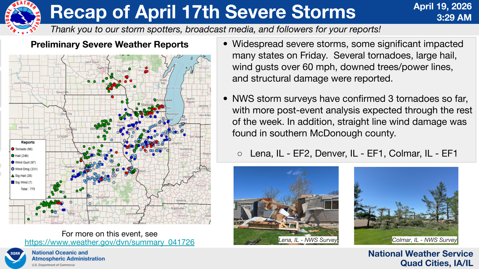
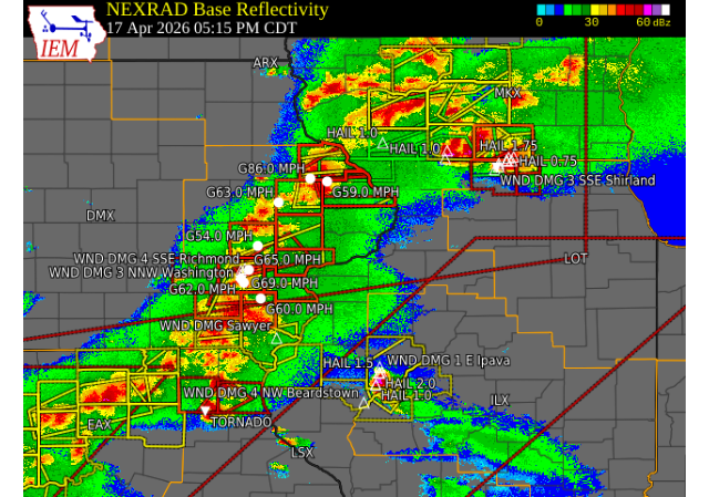
Numerous severe storms tracked across eastern IA, northwest IL, and northeast MO during the afternoon and evening of April 17. Widespread wind gusts between 60-80 mph (isolated 80-100 mph), large hail up to teacup size, and several tornadoes were reported. The most significant damage occurred in Lena, IL where many homes and outbuildings were damaged, trees uprooted, and power lines downed by an EF2 tornado. Very strong straight-line winds also were documented in parts of the area. The NWS is close to finalizing their takeaways in collaboration with county emergency management and neighboring NWS offices. We appreciate your patience as we work through our post-event analysis. |
|
Other NWS Office Event Recaps: Northeast Illinois (NWS Chicago) | Central Illinois (NWS Lincoln)
Tornadoes
Final Public Information Statement on April 17th Event Damage Surveys
NOTE: Tornadoes that crossed NWS Service Areas will NOT appear in the tornado dashboard (table) below, but will on the map.
Select a tornado from the table to zoom into the track and view more information. The default table view is limited to 8 tracks, but can be scrolled by a mouse wheel or dynamically expanded. Additionally, the table can fill the entire window by clicking the small circular expanding arrow icon at the very top right of the table and returned to its original size by clicking the button again. The side information panel that opens over the map can be closed using the "X" on the upper right corner of the pop-up. Zoom into the map and click damage points to see detailed information and pictures from the surveys.
|
NOTE: Times shown below are local to your device's time zone. |

The Enhanced Fujita (EF) Scale classifies tornadoes into the following categories:
| EF0 Weak 65-85 mph |
EF1 Moderate 86-110 mph |
EF2 Significant 111-135 mph |
EF3 Severe 136-165 mph |
EF4 Extreme 166-200 mph |
EF5 Catastrophic 200+ mph |
 |
|||||
| Tornadoes that fail to impact any ratable damage indicators on the EF-Scale are rated EF-Unknown (EF-U) | |||||
 |
 |
||||
| Jo Daviess County, IL Tornado | Stephenson County, IL Tornado | ||||
 |
 |
||||
| Hancock and McDonough Counties, IL Tornado | Mercer County, IL Tornado | ||||
 |
 |
||||
| Hancock County, IL Tornado | Northern Henry County, IL Tornado | ||||
 |
 |
||||
| Hancock and McDonough Counties, IL Tornado | Bureau and LaSalle Counties, IL Tornado | ||||
|
|
|||||
| McDonough and Fulton Counties, IL Tornado | |||||
Storm Reports
 |
Preliminary Local Storm Report...Summary
National Weather Service Quad Cities IA IL

..TIME...   ...EVENT...      ...CITY LOCATION...     ...LAT.LON...
..DATE...   ....MAG....      ..COUNTY LOCATION..ST.. ...SOURCE....
            ..REMARKS..

1249 PM     Hail             2 E Prairieburg         42.25N 91.38W
04/17/2026  E1.00 Inch       Linn               IA   Public

            Report from mPING: Quarter (1.00 in.).

0102 PM     Hail             3 ENE Cedar Rapids      41.99N 91.61W
04/17/2026  E1.00 Inch       Linn               IA   Public

            Photo of quarter size hail relayed via
            social media. Time estimated by radar.

0125 PM     Hail             1 S Cascade             42.28N 91.01W
04/17/2026  E1.00 Inch       Jones              IA   Public

            Report from mPING: Quarter (1.00 in.).
0215 PM Tornado 2 SSW Ironhills 42.13N 90.78W
04/17/2026 Jackson IA Trained Spotter
Spotters and chasers reported a tornado that
lasted for 4 minutes. With no known damage
the rating is an EFU with an estimated path
of 1 mile.
0217 PM Tstm Wnd Dmg 3 S Ironhills 42.11N 90.76W
04/17/2026 Jackson IA Trained Spotter
Powerline snapped and sheet metal roof
ripped off. Likely associated with RFD.
0238 PM Flash Flood 1 SE Menominee 42.46N 90.53W
04/17/2026 Jo Daviess IL Public
Report from mPING: Street/road flooding;
Street/road closed; Vehicles stranded.
0247 PM Tornado 2 ESE Galena Territory 42.39N 90.30W
04/17/2026 Jo Daviess IL NWS Storm Survey
EF1 tornado with max winds speed of 90-95
mph begun just east of the Galena
Territories causing damage to the awning of
house and sporadic tree damage along its 3.7
mile long path.
0251 PM Hail 1 SE Galena 42.41N 90.41W
04/17/2026 E1.25 Inch Jo Daviess IL Public
Report from mPING: Half Dollar (1.25 in.).
0252 PM Hail 2 E Galena 42.41N 90.39W
04/17/2026 E1.50 Inch Jo Daviess IL Public
Report from mPING: Ping Pong Ball (1.50
in.).
0254 PM Hail 2 W Galena Territory 42.39N 90.38W
04/17/2026 E1.50 Inch Jo Daviess IL Public
Report from mPING: Ping Pong Ball (1.50
in.).
0255 PM Hail 1 S Rice 42.32N 90.40W
04/17/2026 M1.75 Inch Jo Daviess IL Trained Spotter
0257 PM Hail 2 S Galena Territory 42.37N 90.33W
04/17/2026 E1.75 Inch Jo Daviess IL Public
Report from mPING: Golf Ball (1.75 in.).
0259 PM Hail 2 N Rodden 42.36N 90.32W
04/17/2026 E1.75 Inch Jo Daviess IL Public
Report from mPING: Golf Ball (1.75 in.).
0300 PM Tstm Wnd Dmg Galena 42.43N 90.43W
04/17/2026 Jo Daviess IL Public
Several branches down ranging from 2-4
inches in diameter. Many yard items also
displaced.
0300 PM Hail 1 E Galena Territory 42.40N 90.31W
04/17/2026 E1.00 Inch Jo Daviess IL Public
Report from mPING: Quarter (1.00 in.).
0301 PM Hail 1 E Rodden 42.34N 90.29W
04/17/2026 E1.75 Inch Jo Daviess IL Public
Report from mPING: Golf Ball (1.75 in.).
0305 PM Hail Hanover 42.25N 90.27W
04/17/2026 M1.50 Inch Jo Daviess IL Trained Spotter
0326 PM Tstm Wnd Gst 1 SSE Warren 42.48N 89.99W
04/17/2026 E70 MPH Jo Daviess IL Trained Spotter
Wind out of the west.
0330 PM Hail Elizabeth 42.32N 90.22W
04/17/2026 M1.25 Inch Jo Daviess IL Trained Spotter
0336 PM Tornado 3 NNE Kent 42.35N 89.87W
04/17/2026 Stephenson IL NWS Storm Survey
A high-end EF2, possible multi-vortex,
tornado with estimated peak winds around 130
mph started along Highway 20, SW of Lena IL,
and tracked through Lena. Extensive damage
was noted to trees, with a lot of damage to
roofs and siding throughout Lena Illinois.
Three houses saw extensive damage, with some
walls that collapsed as well.
0336 PM Hail 2 E Hiawatha 42.05N 91.65W
04/17/2026 M1.00 Inch Linn IA Public
Report from mPING: Quarter (1.00 in.).
0345 PM Flash Flood 1 S Galena 42.41N 90.43W
04/17/2026 Jo Daviess IL Public
Davis Creek on the southeast side of Galena
is out of its banks near 4th and Blackjack
Road. 6 feet higher than normal. water
running across the road.
0349 PM Tstm Wnd Dmg 4 NNE Stockton 42.40N 89.99W
04/17/2026 Jo Daviess IL Trained Spotter
3Ft tree down at the base.
0350 PM Hail 1 S Nora 42.44N 89.94W
04/17/2026 M1.00 Inch Jo Daviess IL Trained Spotter
Time estimated by radar.
0353 PM Hail Toddville 42.10N 91.72W
04/17/2026 M1.00 Inch Linn IA Fire Dept/Rescue
Delayed report. Relayed via county EM.
0353 PM Hail Robins 42.08N 91.67W
04/17/2026 E1.00 Inch Linn IA Fire Dept/Rescue
Relayed via county EM.
0353 PM Hail Hiawatha 42.05N 91.68W
04/17/2026 M1.00 Inch Linn IA Fire Dept/Rescue
Relayed by county EM.
0402 PM Hail 3 ESE Alburnett 42.14N 91.57W
04/17/2026 E1.00 Inch Linn IA Trained Spotter
0403 PM Tstm Wnd Gst Walker 42.29N 91.78W
04/17/2026 E60 MPH Linn IA Fire Dept/Rescue
Relayed via county EM. Also pea sized hail.
0418 PM Hail 2 E Rock Grove 42.46N 89.48W
04/17/2026 E1.75 Inch Stephenson IL Public
Report from mPING: Golf Ball (1.75 in.).
0420 PM Tstm Wnd Gst 4 NE Greeley 42.63N 91.29W
04/17/2026 E60 MPH Delaware IA Emergency Mngr
Report relayed by Emergency Manager. Time
estimated by radar.
0421 PM Flash Flood 1 S Galena 42.41N 90.43W
04/17/2026 Jo Daviess IL Public
Davis Creek overflowing its banks and
flowing across a driveway, with debris.
0424 PM Hail 1 N Dakota 42.39N 89.53W
04/17/2026 M1.75 Inch Stephenson IL Trained Spotter
0424 PM Hail 2 W Dakota 42.38N 89.57W
04/17/2026 E3.00 Inch Stephenson IL Public
Report from mPING: Tea Cup (3.00 in.).
0425 PM Hail 3 SW Winneshiek 42.32N 89.57W
04/17/2026 E1.00 Inch Stephenson IL Public
Report from mPING: Quarter (1.00 in.).
0429 PM Hail Winneshiek 42.34N 89.53W
04/17/2026 E1.75 Inch Stephenson IL Public
Report from mPING: Golf Ball (1.75 in.).
0432 PM Hail 3 NNE Stockton 42.40N 89.99W
04/17/2026 M1.00 Inch Jo Daviess IL Public
Photos relayed via social media.
0440 PM Hail 2 NNE Davis 42.45N 89.40W
04/17/2026 M2.00 Inch Stephenson IL NWS Employee
0444 PM Rain 1 NW Galena 42.43N 90.44W
04/17/2026 M1.60 Inch Jo Daviess IL Trained Spotter
0445 PM Hail Dakota 42.39N 89.53W
04/17/2026 M2.75 Inch Stephenson IL Public
report from LOT on Dakota storm.. they
received a photo of baseball size hail..
0450 PM Hail 4 NNE Hopkinton 42.40N 91.22W
04/17/2026 M1.25 Inch Delaware IA Emergency Mngr
0452 PM Tstm Wnd Dmg Rubio 41.22N 91.93W
04/17/2026 Washington IA Trained Spotter
Tree limbs several inches in diameter down.
0452 PM Tstm Wnd Gst 3 WNW Cascade 42.31N 91.07W
04/17/2026 E67 MPH Dubuque IA Emergency Mngr
Report relayed by Emergency Manager. Time
estimated by radar.
0500 PM Tstm Wnd Gst 2 W Washington 41.30N 91.72W
04/17/2026 M62 MPH Washington IA Amateur Radio
0500 PM Tstm Wnd Gst 1 NW Cascade 42.31N 91.02W
04/17/2026 M86 MPH Dubuque IA Emergency Mngr
0501 PM Tstm Wnd Gst 2 SSW Washington Airpor 41.26N 91.69W
04/17/2026 M69 MPH Washington IA Mesonet
0502 PM Tornado 4 E West Chester 41.35N 91.75W
04/17/2026 Washington IA NWS Storm Survey
An EF1 tornado with estimated max winds of
100-105 mph begun roughly 4 miles
east-northeast of West Chester, IA. Along
its 5.3 mile path, it snapped several power
poles and tree trunks, along with ripping
sheet metal roofs off of farm outbuildings.
A semi truck was also tipped over near the
intersection of State Highway 1 and 92 due
to a localized wind surge.
0502 PM Funnel Cloud 1 NNE Mt Hamill 40.76N 91.61W
04/17/2026 Lee IA Trained Spotter
Cone funnel cloud.
0512 PM Tstm Wnd Gst 5 SE Richmond 41.39N 91.64W
04/17/2026 M65 MPH Washington IA Mesonet
0512 PM Tstm Wnd Gst 1 W Garry Owen 42.28N 90.85W
04/17/2026 M59 MPH Jackson IA Mesonet
0520 PM Tstm Wnd Gst 1 SSW Fairview 42.07N 91.34W
04/17/2026 M63 MPH Jones IA Dept of Highways
RWIS.
0523 PM Tstm Wnd Gst Iowa City Municipality 41.63N 91.55W
04/17/2026 M54 MPH Johnson IA Public
ASOS.
0524 PM Tstm Wnd Gst Lone Tree 41.48N 91.43W
04/17/2026 M71 MPH Johnson IA Emergency Mngr
Corrects previous tstm wnd gst report of 61
MPH from Lone Tree. Measured wind gust of 71
MPH at School in town. Tree blown over onto
powerlines. The time of the event was
estimated using radar.
0529 PM Tstm Wnd Gst 1 ENE Swedesburg 41.10N 91.52W
04/17/2026 M60 MPH Henry IA Mesonet
0541 PM Tstm Wnd Dmg Sawyer 40.70N 91.36W
04/17/2026 Lee IA Public
Large tree fallen down and multiple thick
limbs snapped. Time estimated from radar.
0547 PM Tstm Wnd Gst 3 NNE Wapello 41.21N 91.16W
04/17/2026 M60 MPH Louisa IA Mesonet
0549 PM Tstm Wnd Gst 3 N Wilton 41.63N 91.02W
04/17/2026 E60 MPH Cedar IA Trained Spotter
0556 PM Tstm Wnd Gst 2 NNW Durant 41.63N 90.92W
04/17/2026 E91 MPH Cedar IA Trained Spotter
Measured using a car anemometer.
0557 PM Tstm Wnd Gst Fort Madison Municipali 40.67N 91.33W
04/17/2026 M54 MPH Lee IA AWOS
AWOS.
0603 PM Tstm Wnd Gst Burlington Regional Air 40.78N 91.13W
04/17/2026 M47 MPH Des Moines IA ASOS
ASOS.
0613 PM Tstm Wnd Dmg New Boston 41.17N 91.00W
04/17/2026 Mercer IL Trained Spotter
Multiple downed tree branches, including
some up to 3 inches thick. Portapotty blown
over. Time estimated from radar.
0615 PM Tstm Wnd Gst 2 SSW Donahue 41.67N 90.69W
04/17/2026 M63 MPH Scott IA Mesonet
0615 PM Tstm Wnd Gst 2 W Donahue 41.69N 90.71W
04/17/2026 M58 MPH Scott IA Mesonet
0618 PM Tstm Wnd Gst 2 SSE Dallas City 40.61N 91.16W
04/17/2026 M63 MPH Hancock IL Mesonet
0618 PM Tstm Wnd Gst 1 NW Park View 41.70N 90.55W
04/17/2026 M62 MPH Scott IA Trained Spotter
0619 PM Tstm Wnd Gst Davenport Municipality 41.61N 90.59W
04/17/2026 M66 MPH Scott IA ASOS
ASOS.
0628 PM Tstm Wnd Gst 5 SE Loran 42.18N 89.85W
04/17/2026 M58 MPH Carroll IL Mesonet
0634 PM Tstm Wnd Gst Clinton Municipality 41.83N 90.33W
04/17/2026 M58 MPH Clinton IA AWOS
AWOS.
0635 PM Tstm Wnd Gst 1 S Low Moor 41.80N 90.35W
04/17/2026 M65 MPH Clinton IA Trained Spotter
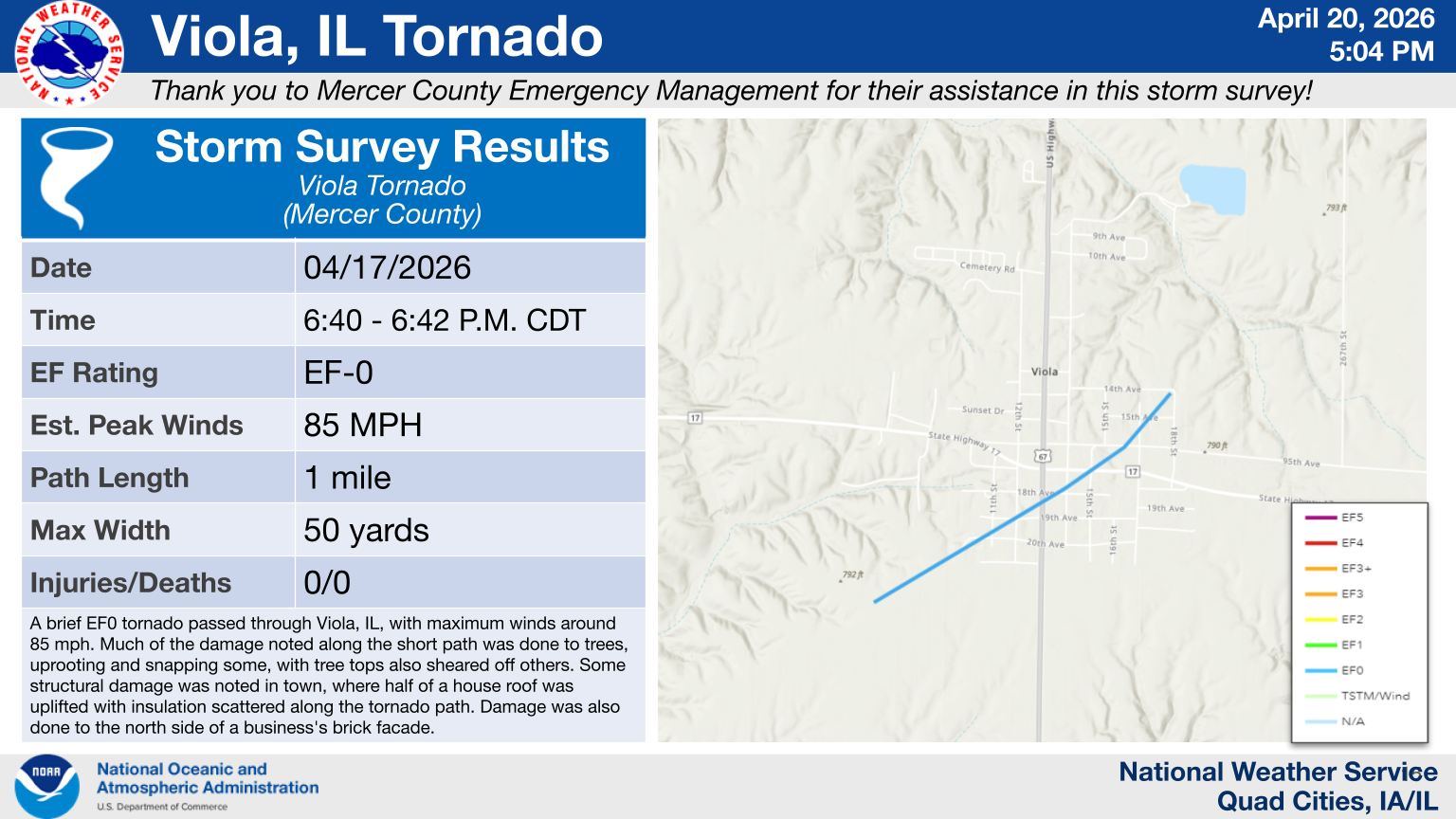
0640 PM Tornado 1 SW Viola 41.20N 90.60W
04/17/2026 Mercer IL NWS Storm Survey
A brief EF0 tornado passed through Viola,
IL, with maximum winds around 85 mph. Damage
along the short path was done to trees, both
uprooting and snapping, with tree tops also
sheared off others. Structural damage in
town included half of a house roof uplifted,
insulation scattered along the path, and
damage to the north side of a brick facade.
0640 PM Tstm Wnd Dmg 2 S Eleanor 40.96N 90.70W
04/17/2026 Warren IL Trained Spotter
Reported 60 mph winds for 20 minutes along
with tree limb damage. Time estimated by
radar.
0645 PM Hail Buda 41.33N 89.68W
04/17/2026 E1.75 Inch Bureau IL Public
Hail up to the size of golf balls. Time
estimated by radar.
0647 PM Tstm Wnd Dmg 1 E Sheffield 41.36N 89.71W
04/17/2026 Bureau IL Emergency Mngr
Powerpole broken.
0654 PM Tstm Wnd Gst 1 NNW Union Grove 41.84N 90.04W
04/17/2026 M61 MPH Whiteside IL Mesonet
0654 PM Tstm Wnd Dmg Basco 40.33N 91.20W
04/17/2026 Hancock IL Emergency Mngr
Home damaged.
0655 PM Tornado 2 NE West Point 40.27N 91.16W
04/17/2026 Hancock IL NWS Storm Survey
A high-end EF1 tornado developed southwest
of Denver IL and tracked through town.
Through the path of the tornado, there were
dozens of utility poles damaged. When
factoring in the rear flank downdraft (RFD),
over 50 poles were broken or bent. Many
trees were snapped, some in Denver with high
concentration. Some structural damage was
also seen, largely to facades, windows, and
roofs in Denver.
0659 PM Tstm Wnd Gst 4 SSE Osborn 41.46N 90.24W
04/17/2026 M66 MPH Henry IL Mesonet
0659 PM Tstm Wnd Gst 3 ESE Hamilton 40.37N 91.31W
04/17/2026 M58 MPH Hancock IL Mesonet
0704 PM     Tornado          3 S Spring Hill         41.57N 90.05W
04/17/2026                   Henry              IL   NWS Storm Survey

            A short lived EF1 tornado with max winds
            around 100 mph impacted a farmstead in far
            northern Henry County Illinois, with max
            width around 50 yards. Damage was largely
            noted to a couple of farm outbuildings and
            some minor tree damage.
0712 PM     Tstm Wnd Dmg     1 E Plymouth            40.29N 90.91W
04/17/2026                   McDonough          IL   Trained Spotter

            Tree blown down.

0713 PM     Tornado          4 WNW Colmar            40.37N 90.96W
04/17/2026                   Hancock            IL   NWS Storm Survey

            An EF-1 tornado starting in Hancock County
            tracked east-southeast before turning east
            through western McDonough County. It tracked
            just north of Colmar. Along the path was
            concentrated tree snapping, many at the
            base, and some uprooted. Structural damage
            was noted at several outbuildings, including
            one destroyed. Several power poles were
            snapped or heavily leaning on the nearby
            railroad track.

0720 PM     Tstm Wnd Dmg     1 ENE Tennessee         40.42N 90.82W
04/17/2026                   McDonough          IL   Emergency Mngr

            structure damaged.
0729 PM     Tornado          4 NE Industry           40.37N 90.56W
04/17/2026                   McDonough          IL   NWS Storm Survey

            The tornado began about 3.5 miles northeast
            of Industry where it did some tree damage
            followed by snapping of 7 power poles along
            N 600th Rd. It progressed east between N
            600th Rd and N 500th Rd as it produced tree
            and significant outbuilding damage. The
            tornado then turned northeast where it did
            significant tree damage, producing wind
            speeds around 115 mph. It then crossed into
            the NWS Central Illinois CWA.

0730 PM     Tstm Wnd Dmg     4 W Industry            40.34N 90.68W
04/17/2026                   McDonough          IL   Trained Spotter

            Tree limbs down, Aluminum flag pole snapped
            off approximately 8 feet above ground.

0731 PM     Tstm Wnd Gst     4 E Fandon              40.37N 90.70W
04/17/2026  M73 MPH          McDonough          IL   Mesonet

            Corrects previous tstm wnd gst report
            timing.

0731 PM     Tstm Wnd Dmg     1 NW Industry           40.34N 90.62W
04/17/2026                   McDonough          IL   Emergency Mngr

            Power poles down.

0752 PM     Tstm Wnd Dmg     Tiskilwa                41.29N 89.51W
04/17/2026                   Bureau             IL   Emergency Mngr

            Tree blown down.

0801 PM     Tstm Wnd Gst     Hennepin                41.26N 89.32W
04/17/2026  M58 MPH          Putnam             IL   Trained Spotter

            A trained spotter measured a 58 MPH.

0810 PM     Tstm Wnd Dmg     Spring Valley           41.33N 89.20W
04/17/2026                   Bureau             IL   Emergency Mngr

            Multiple trees blown down.

0812 PM     Tornado          2 ESE Arlington         41.46N 89.21W
04/17/2026                   Bureau             IL   NWS Storm Survey

            An EF-1 tornado developed in far eastern
            Bureau County, with estimated max winds of
            90 mph. A barn sustained roofing damage. The
            tornado then moved NE into LaSalle County,
            resulting in damage to trees, power poles,
            and outbuildings.
Photos
 |
 |
 |
 |
|
Gregg Alliss |
Landon Moeller Galena, IL |
Jason Leverton Orangeville, IL |
Galva ESDA Bishop Hill, IL |
 |
 |
 |
 |
|
Alicia Ottman |
Alicia Ottman |
NWS Storm Survey |
NWS Storm Survey |
 |
 |
 |
 |
|
NWS Storm Survey |
NWS Storm Survey |
NWS Storm Survey Lena, IL |
NWS Storm Survey Lena, IL |
|
|||
| NWS Storm Survey Lena, IL |
Rain Reports
 |
 |
|
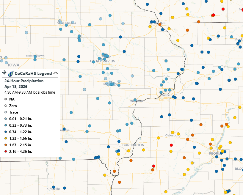
24-hr Rainfall Ending April 18th 7 AM |
24-hr CoCoRaHS Reports Ending April 18th |
Public Information Statement
National Weather Service Quad Cities IA IL
120 PM CDT Sat Apr 18 2026

...Highest 24-hour Rain Reports...

Location                     Amount    Time/Date       Lat/Lon
1 W Macomb                   2.80 in   0900 AM 04/18   40.47N/90.70W
Macomb 3.8 NW                2.25 in   0740 AM 04/18   40.52N/90.72W
1 ESE Carthage               2.25 in   0858 AM 04/18   40.41N/91.13W
Colchester 3.5 NE            1.95 in   0700 AM 04/18   40.46N/90.75W
La Harpe                     1.95 in   0700 AM 04/18   40.58N/90.97W
East Dubuque 1.7 SE          1.90 in   0700 AM 04/18   42.48N/90.61W
Macomb                       1.89 in   0700 AM 04/18   40.48N/90.67W
Warsaw 5.8 SE                1.87 in   0700 AM 04/18   40.29N/91.36W
2 NNE Colusa                 1.87 in   0700 AM 04/18   40.59N/91.15W
Stockton 5.9 WNW             1.85 in   0700 AM 04/18   42.40N/90.10W
Dallas City 3.0 SSE          1.84 in   0700 AM 04/18   40.59N/91.15W
Middleburg                   1.82 in   1230 PM 04/18   42.41N/90.35W
Freeport                     1.74 in   1240 PM 04/18   42.33N/89.63W
Macomb Arpt                  1.73 in   1235 PM 04/18   40.52N/90.65W
Bentley                      1.73 in   0800 AM 04/18   40.34N/91.11W
Keokuk 3.4 NW                1.72 in   0600 AM 04/18   40.44N/91.45W
McNabb 1.4 NW                1.65 in   0700 AM 04/18   41.19N/89.23W
Kahoka                       1.63 in   1235 PM 04/18   40.38N/91.63W
2 W Wayland                  1.61 in   0800 AM 04/18   40.39N/91.63W
Montrose 4.5 NNW             1.61 in   1000 AM 04/18   40.59N/91.44W
Bushnell                     1.60 in   0806 AM 04/18   40.55N/90.50W
1 NW Galena                  1.60 in   0444 PM 04/17   42.43N/90.44W
Burlington 6.5 SSW           1.60 in   0700 AM 04/18   40.73N/91.19W
Galena 0.8 WSW               1.58 in   0700 AM 04/18   42.42N/90.44W
Monmouth, IL                 1.53 in   0730 AM 04/18   40.91N/90.64W
Monmouth                     1.50 in   1235 PM 04/18   40.93N/90.63W
Keosauqua                    1.50 in   0846 AM 04/18   40.73N/91.96W
Dubuque 7 SSW                1.50 in   0600 AM 04/18   42.41N/90.73W
Burlington 0.8 SSE           1.50 in   1006 AM 04/18   40.80N/91.11W
Stronghurst 0.4 SSW          1.49 in   0700 AM 04/18   40.74N/90.91W
Fort Madison 4.5 NNW         1.47 in   0800 AM 04/18   40.68N/91.38W
Hanover 0.2 NW               1.45 in   0700 AM 04/18   42.26N/90.28W
Elizabeth                    1.36 in   0630 AM 04/18   42.32N/90.23W
Mount Carroll                1.34 in   1230 PM 04/18   42.22N/89.95W
Burlington Arpt              1.33 in   1153 AM 04/18   40.77N/91.13W
Anamosa 3 SSW                1.31 in   0700 AM 04/18   42.08N/91.30W
Davis 0.5 N                  1.30 in   0700 AM 04/18   42.43N/89.42W
Peosta 2.9 E                 1.29 in   0700 AM 04/18   42.44N/90.79W
Dubuque Arpt                 1.28 in   1153 AM 04/18   42.40N/90.70W
Freeport 4.3 W               1.23 in   0500 AM 04/18   42.29N/89.72W
CENTRAL CITY                 1.23 in   1240 PM 04/18   42.20N/91.53W
Prophetstown 0.2 SW          1.22 in   0700 AM 04/18   41.67N/89.94W
1.0 NW Niota                 1.19 in   1230 PM 04/18   40.63N/91.30W
Lanark 0.3 SSW               1.17 in   0500 AM 04/18   42.10N/89.83W
Wapsipinicon River           1.17 in   1215 PM 04/18   42.08N/91.27W
Ridott 3.2 WNW               1.16 in   0500 AM 04/18   42.32N/89.53W
Lanark 6.0 E                 1.14 in   0700 AM 04/18   42.10N/89.72W
Mount Carroll                1.13 in   0856 AM 04/18   42.10N/89.98W
2 W Bolton                   1.10 in   1200 AM 04/18   42.26N/89.77W
Stockton                     1.10 in   1230 PM 04/18   42.40N/89.99W
Atkinson 2.6 NNE             1.10 in   0800 AM 04/18   41.45N/89.99W
Lanark 5.3 N                 1.10 in   1006 AM 04/18   42.18N/89.85W
Danville 2.9 W               1.09 in   0700 AM 04/18   40.86N/91.37W
Freeport 2.9 WSW             1.08 in   0835 AM 04/18   42.27N/89.68W
Stockton 3 Nne               1.08 in   0700 AM 04/18   42.40N/90.00W
Galva                        1.08 in   0800 AM 04/18   41.16N/90.03W
Hopkinton 5.4 WSW            1.07 in   0700 AM 04/18   42.30N/91.34W
Walnut 5.3 ENE               1.05 in   0700 AM 04/18   41.58N/89.50W
0.9 W Wayland                1.04 in   1230 PM 04/18   40.39N/91.60W
Anamosa 0.6 ESE              1.03 in   0900 AM 04/18   42.11N/91.27W
Prophetstown 0.6 ESE         1.01 in   0600 AM 04/18   41.67N/89.92W
Fort Madison Arpt            1.00 in   1235 PM 04/18   40.67N/91.32W
Van Horne 2.1 NNW            1.00 in   0700 AM 04/18   42.04N/92.11W
Mount Carroll 6.8 NNW        0.99 in   0700 AM 04/18   42.19N/90.02W
Spring Valley Airport        0.98 in   1245 PM 04/18   41.33N/89.21W
Geneseo 2.0 NW               0.94 in   0700 AM 04/18   41.47N/90.18W
Augusta                      0.92 in   0803 AM 04/18   40.23N/90.95W
Colona 0.5 ESE               0.91 in   0700 AM 04/18   41.47N/90.33W
Coleta 1.4 SSW               0.90 in   0700 AM 04/18   41.89N/89.81W
SHELLSBURG                   0.88 in   1235 PM 04/18   42.09N/91.87W
2 N Muscatine                0.85 in   0700 AM 04/18   41.47N/91.05W
New Windsor 2.0 N            0.80 in   0700 AM 04/18   41.23N/90.44W
Cedar Rapids Arpt            0.80 in   1152 AM 04/18   41.88N/91.72W
No.2-River                   0.79 in   1230 PM 04/18   42.50N/90.65W
Farmington 3.5 W             0.78 in   0700 AM 04/18   40.63N/91.81W
Sterling                     0.77 in   1235 PM 04/18   41.82N/89.67W
Washington                   0.77 in   1245 PM 04/18   41.29N/91.69W
Farmington 2.4 W             0.77 in   0700 AM 04/18   40.63N/91.78W
Farmington 0.3 NW            0.76 in   0700 AM 04/18   40.64N/91.74W
Farmington 0.4 NNW           0.75 in   0700 AM 04/18   40.64N/91.74W
...COCORAHS PRECIPITATION REPORTS...

THESE REPORTS ARE CONSIDERED SUPPLEMENTAL AND UNOFFICIAL
VALUES ARE FOR THE PREVIOUS 24 HOURS ENDING AROUND 7 AM LOCAL TIME

FOR MORE INFORMATION ON THE COCORAHS PROGRAM, PLEASE VISIT
WWW.COCORAHS.ORG

.B DVN 0418 C DH07/PP/SF/SD/SW
:
:
:COCORAHS PRECIPITATION REPORTS IN ILLINOIS
:
:                                          SNOW   SNOW    WATER
:                                   PCPN   FALL   DEPTH   EQUIV
:
IL-MCD-06 : MACOMB 3.8 NW         : 2.25 /   MM /    MM /    MM
IL-MCD-07 : COLCHESTER 3.5 NE     : 1.95 /   MM /    MM /    MM
IL-JD-11  : EAST DUBUQUE 1.7 SE   : 1.90 /   MM /    MM /    MM
IL-JD-15  : STOCKTON 5.9 WNW      : 1.85 /   MM /    MM /    MM
IL-HN-01  : DALLAS CITY 3.0 SSE   : 1.84 /  0.0 /   0.0 /  0.00
IL-PM-06  : MCNABB 1.4 NW         : 1.65 /   MM /    MM /    MM
IL-WR-07  : MONMOUTH 0.4 SE       : 1.53 /   MM /    MM /    MM
IL-JD-06  : HANOVER 0.2 NW        : 1.45 /   MM /    MM /    MM
IL-SP-07  : DAVIS 0.5 N           : 1.30 /   MM /    MM /    MM
IL-SP-28  : FREEPORT 4.3 W        : 1.23 /   MM /    MM /    MM
IL-WD-18  : PROPHETSTOWN 0.2 SW   : 1.22 /   MM /    MM /    MM
IL-MR-10  : VIOLA 0.4 E           : 1.20 /   MM /    MM /    MM
IL-CR-25  : LANARK 0.3 SSW        : 1.17 /   MM /    MM /    MM
IL-SP-35  : RIDOTT 3.2 WNW        : 1.16 /   MM /    MM /    MM
IL-CR-18  : LANARK 6.0 E          : 1.14 /   MM /    MM /    MM
IL-CR-20  : LANARK 5.3 N          : 1.10 /   MM /    MM /    MM
IL-HY-04  : ATKINSON 2.6 NNE      : 1.10 /   MM /    MM /    MM
IL-HY-25  : GALVA 0.9 SE          : 1.08 /   MM /    MM /    MM
IL-SP-26  : FREEPORT 2.9 WSW      : 1.08 /   MM /    MM /    MM
IL-BU-11  : WALNUT 5.3 ENE        : 1.05 /   MM /    MM /    MM
IL-CR-12  : MOUNT CARROLL 6.8 NNW : 0.99 /  0.0 /   0.0 /    MM
IL-HY-08  : GENESEO 2.0 NW        : 0.94 /   MM /    MM /    MM
IL-HY-30  : COLONA 0.5 ESE        : 0.91 /   MM /    MM /    MM
IL-WD-08  : COLETA 1.4 SSW        : 0.90 /   MM /    MM /    MM
IL-HY-06  : NEW WINDSOR 2.0 N     : 0.80 /   MM /    MM /    MM
IL-HY-27  : COLONA 1.3 WNW        : 0.74 /   MM /    MM /    MM
IL-WD-05  : MORRISON 3.2 E        : 0.70 /   MM /    MM /    MM
IL-WD-22  : ROCK FALLS 3.1 S      : 0.66 /   MM /    MM /    MM
:
:
:COCORAHS PRECIPITATION REPORTS IN EASTERN IOWA
:
:                                          SNOW   SNOW    WATER
:                                   PCPN   FALL   DEPTH   EQUIV
:
IA-LE-16  : KEOKUK 3.4 NW         : 1.72 /   MM /    MM /    MM
IA-LE-03  : MONTROSE 4.5 NNW      : 1.61 /   MM /    MM /    MM
IA-DM-07  : BURLINGTON 6.5 SSW    : 1.60 /   MM /    MM /    MM
IA-LE-20  : FORT MADISON 4.5 NNW  : 1.47 /   MM /    MM /    MM
IA-DB-16  : PEOSTA 2.9 E          : 1.29 /   MM /    MM /    MM
IA-DM-18  : DANVILLE 2.9 W        : 1.09 /   MM /    MM /    MM
IA-DW-06  : HOPKINTON 5.4 WSW     : 1.07 /   MM /    MM /    MM
IA-JN-16  : ANAMOSA 0.6 ESE       : 1.03 /   MM /    MM /    MM
IA-BT-23  : VAN HORNE 2.1 NNW     : 1.00 /   MM /    MM /    MM
IA-DB-31  : BELLEVUE 12.2 NW      : 0.99 /   MM /    MM /    MM
IA-LE-21  : FORT MADISON 7.7 N    : 0.90 /   MM /    MM /    MM
IA-BT-26  : VAN HORNE 3.4 SSW     : 0.85 /   MM /    MM /    MM
IA-VB-03  : FARMINGTON 3.5 W      : 0.78 /  0.0 /   0.0 /  0.00
IA-VB-08  : FARMINGTON 2.4 W      : 0.77 /  0.0 /   0.0 /  0.00
IA-DB-20  : ASBURY 0.4 SW         : 0.76 /   MM /    MM /    MM
IA-VB-07  : FARMINGTON 0.3 NW     : 0.76 /  0.0 /   0.0 /  0.00
IA-VB-09  : FARMINGTON 0.4 NNW    : 0.75 /  0.0 /   0.0 /  0.00
IA-CN-05  : CAMANCHE 1.2 W        : 0.74 /   MM /    MM /    MM
IA-CN-22  : CLINTON 1.7 NNW       : 0.74 /   MM /    MM /    MM
IA-LN-07  : CENTRAL CITY 6.7 W    : 0.72 /   MM /    MM /    MM
IA-CN-25  : CLINTON 1.3 NNE       : 0.58 /   MM /    MM /    MM
IA-ST-70  : BETTENDORF 2.4 ENE    : 0.58 /  0.0 /   0.0 /  0.00
IA-WS-02  : AINSWORTH 7.4 N       : 0.58 /   MM /    MM /    MM
IA-LN-53  : ROBINS 0.8 SE         : 0.56 /  0.0 /   0.0 /  0.00
IA-JF-14  : FAIRFIELD 0.7 SE      : 0.55 /   MM /    MM /    MM
IA-LS-05  : WAPELLO 5.4 SE        : 0.55 /   MM /    MM /    MM
IA-DM-15  : YARMOUTH 1.9 SW       : 0.51 /   MM /    MM /    MM
IA-ST-65  : DAVENPORT 4.3 NE      : 0.51 /  0.0 /   0.0 /    MM
IA-LS-02  : MORNING SUN 1.7 E     : 0.49 /   MM /    MM /    MM
IA-LN-03  : ELY 0.5 SE            : 0.46 /   MM /    MM /    MM
IA-ST-30  : ELDRIDGE 0.7 SSW      : 0.45 /  0.0 /    MM /    MM
IA-BT-24  : MOUNT AUBURN 0.1 SSW  : 0.44 /  0.0 /   0.0 /  0.00
IA-IA-02  : MARENGO 2.6 SSW       : 0.44 /   MM /    MM /    MM
IA-ST-03  : PARK VIEW 0.2 WSW     : 0.44 /   MM /    MM /    MM
IA-JF-12  : FAIRFIELD 5.7 NNE     : 0.43 /   MM /    MM /    MM
IA-BC-08  : INDEPENDENCE 0.9 WNW  : 0.41 /   MM /    MM /    MM
IA-HY-09  : MOUNT UNION 3.6 S     : 0.40 /   MM /    MM /    MM
IA-LN-54  : CEDAR RAPIDS 4.1 NW   : 0.39 /   MM /    MM /    MM
IA-ST-37  : DAVENPORT 0.9 WNW     : 0.39 /   MM /    MM /    MM
IA-WS-07  : WELLMAN 4.0 E         : 0.39 /   MM /    MM /    MM
IA-CN-17  : CHARLOTTE 1.9 WNW     : 0.38 /   MM /    MM /    MM
IA-JH-49  : SWISHER 2.6 SE        : 0.38 /   MM /    MM /    MM
IA-ST-55  : LONG GROVE 5.0 ENE    : 0.38 /   MM /    MM /    MM
IA-LN-31  : CEDAR RAPIDS 2.7 NE   : 0.36 /   MM /    MM /    MM
IA-BT-11  : MOUNT AUBURN 2.2 NNW  : 0.33 /   MM /    MM /    MM
IA-JH-38  : WEST BRANCH 2.3 SSW   : 0.33 /   MM /    MM /    MM
IA-BT-12  : FAIRFAX 4.0 NW        : 0.31 /  0.0 /   0.0 /  0.00
IA-LN-63  : MARION 0.9 NE         : 0.29 /   MM /    MM /    MM
IA-JH-54  : IOWA CITY 2.3 E       : 0.28 /   MM /    MM /    MM
IA-CN-02  : CALAMUS 2.0 NE        : 0.27 /   MM /    MM /    MM
IA-JH-37  : SOLON 0.4 WNW         : 0.27 /   MM /    MM /    MM
IA-KK-07  : HAYESVILLE 0.2 SW     : 0.27 /   MM /    MM /    MM
IA-DW-10  : DUNDEE 1.4 NNE        : 0.25 /   MM /    MM /    MM
IA-LN-59  : MARION 0.4 NNW        : 0.25 /   MM /    MM /    MM
IA-LN-27  : MARION 1.7 NNW        : 0.24 /   MM /    MM /    MM
IA-JH-55  : IOWA CITY 1.3 ESE     : 0.22 /   MM /    MM /    MM
IA-BC-09  : WINTHROP 5.6 NNE      : 0.19 /   MM /    MM /    MM
IA-JH-50  : IOWA CITY 3.7 E       : 0.19 /   MM /    MM /    MM
IA-JH-63  : IOWA CITY 3.5 E       : 0.19 /   MM /    MM /    MM
IA-LN-49  : CEDAR RAPIDS 2.1 NW   : 0.17 /   MM /    MM /    MM
IA-CD-07  : WEST BRANCH 2.0 NNW   : 0.13 /   MM /    MM /    MM
IA-JH-41  : IOWA CITY 2.7 E       : 0.11 /   MM /    MM /    MM
IA-CD-08  : TIPTON 0.3 ESE        : 0.10 /   MM /    MM /    MM
IA-IA-13  : PARNELL 0.1 SSW       : 0.10 /   MM /    MM /    MM
IA-JH-57  : IOWA CITY 1.2 WSW     : 0.10 /   MM /    MM /    MM
IA-JH-27  : NORTH LIBERTY 0.7 SSW : 0.08 /   MM /    MM /    MM
IA-JH-48  : CORALVILLE 1.7 SSE    : 0.08 /   MM /    MM /    MM
IA-JH-61  : IOWA CITY 2.0 WSW     : 0.08 /   MM /    MM /    MM
IA-JH-58  : IOWA CITY 1.4 NNE     : 0.07 /   MM /    MM /    MM
IA-JH-64  : IOWA CITY 1.5 NNE     : 0.06 /  0.0 /    MM /    MM
:
:
:COCORAHS PRECIPITATION REPORTS IN NORTHEAST MISSOURI
:
:                                          SNOW   SNOW    WATER
:                                   PCPN   FALL   DEPTH   EQUIV
:
MO-CK-04  : KAHOKA 5.2 ESE        : 1.61 /   MM /    MM /    MM
.END
Environment
 |
 |
 |
 |
| 20z - 500 mb Analysis | 20z - 700 mb Analysis | 20z - 850 mb Analysis | 20z - 925 mb Analysis |
Near-storm environment
 |
 |
 |
| 4/17 - 18Z DVN Sounding | 4/17 - 21Z DVN Sounding | 4/18 - 00Z DVN Sounding |
Additional environmental data.
 |
 |
 |
 |
|
CAPE - Atmospheric Instability Favorable For Developing Storms |
0-6 km Shear Favorable For Storm Organization |
Downdraft CAPE Favorable for Strong Downdrafts |
Low-Level Lapse Rates Favorable for Atmospheric Instability |
 |
 |
 |
 |
|
Supercell Composite Favorable for Supercells |
0-3 km Shear/CAPE Favorable for Mesovortex Development |
0-1 km Shear Favorable for Tornadoes |
Precipitable Water Favorable for Heavy Rain |
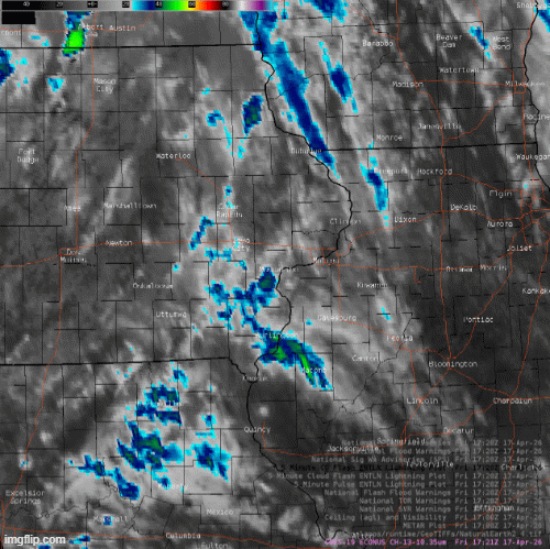 |
| IR Satellite Loop - April 17th |
Service
SPC Outlooks
 |
 |
 |
 |
|
Convective Outlook |
Tornado Threat |
Hail Threat |
Wind Threat |
NWS Quad Cities Weather Stories
 |
 |
 |
|
Weather Story Issued April 16 P.M. |
Weather Story Issued April 17 A.M. |
Weather Story Issued April 17 A.M. |
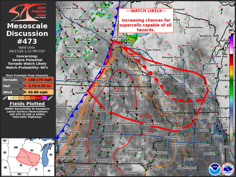
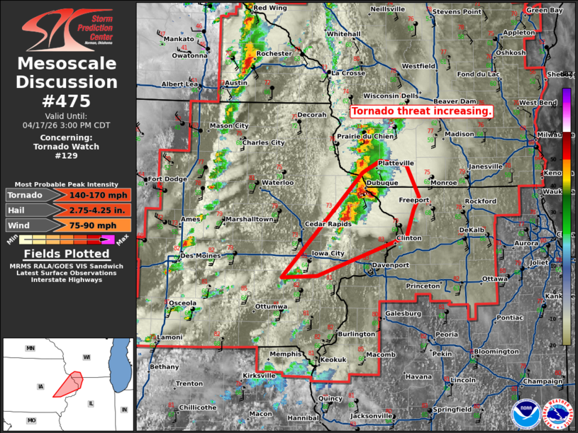
Severe/Tornado Watches & MCDs
 |
 |
 |
 |
|
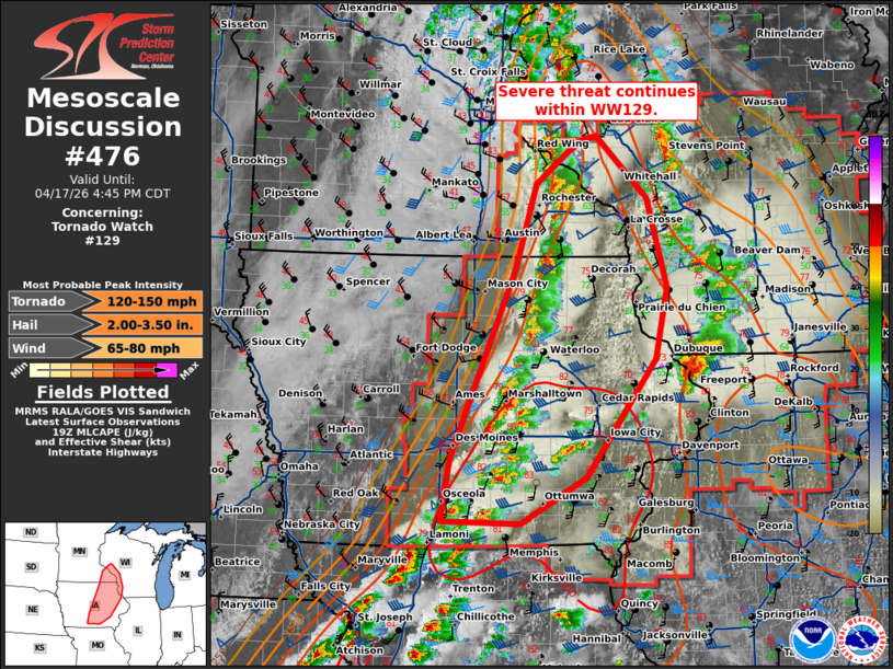
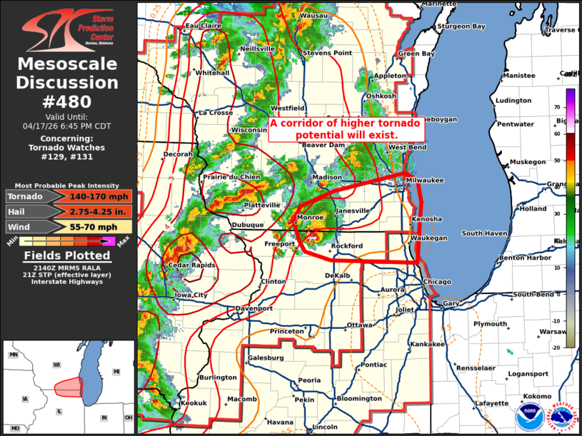
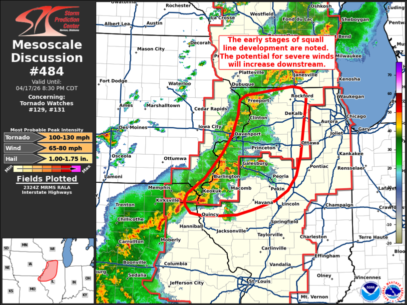
Tornado Watch 129 |
 |
 |
NWS Quad Cities Graphicasts
 |
 |
 |
|
Graphicast issued at 11:53 A.M. CDT |
Graphicast issued at 1:26 P.M. CDT |
Graphicast issued at 4:26 P.M. CDT |
NWS Quad Cities Warnings (two of the 50 warnings issued by the office -- second most in the office's existence after 3/31/2023 [56])
 |
 |
 |
|
Tornado Warning including Lena, IL issued at 2:48 PM CDT. |
Tornado Warning including Washington County issued at 4:36 PM CDT. |
Tornado Warning for Hancock County including Denver, IL at 6:25 PM CDT |
 |
Media use of NWS Web News Stories is encouraged! Please acknowledge the NWS as the source of any news information accessed from this site. |
|