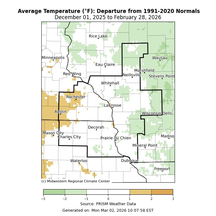
Temperatures: Highly Variable
- During the meteorological winter (December 1 through February 28) of 2025-26, average temperatures ranged from 15.2°F at Medford Taylor County Airport, WI (AWOS) to 22.5°F at Guttenberg Lock & Dam 10, IA (COOP)
- These temperatures ranged from 2°F colder than normal to 2°F warmer than normal. While temperature for the season averaged near normal, they were highly variable.
- There was a 98°F temperature difference between the warmest and coldest temperature.
- The warmest temperature was 66°F at Prairie du Chien, WI on February 17. The coldest temperature was -32°F at near Owen, WI (COOP) on January 25.
|
 |
Precipitation: Below Normal
- Precipitation ranged from 1.31" near Osage, IA (CoCoRaHS) to 3.73" near Westby, WI (CoCoRaHS).
- These precipitation values ranged from 2" below normal to 3" above normal.
- The greatest 1-day precipitation total was 2.38" near Wilton, WI (CoCoRaHS) from 7 am on January 8 through 7 am on January 9.
|
 |
Snowfall: Near to Well-Below Normal
- Snowfall ranged from 11.3" near Wykoff, MN (CoCoRaHS) to 35.5" near Mather, WI (COOP).
- These snowfall values ranged from 24" below normal to 6" above normal.
- The greatest 1-day snowfall total was 13.5" near New Hampton, IA (CoCoRaHS) from 7 am on February 19 to 7 am on February 20.
|
 |
Below are climate summaries for La Crosse, WI, and Rochester, MN.
La Crosse, WI
Meteorological Winter 2025-26 was Drier and Colder than Normal in La Crosse, WI
Temperatures - Colder than Normal
- From December 1 through February 28, the average temperature at La Crosse Regional Airport was 20.7°F. This was 1.8°F colder than the 1991-2020 winter normal of 22.5°F.
- The average maximum temperature was 29.1°F. This was 1.8°F colder than the 1991-2020 normal of 30.9°F.
- The average minimum temperature was 12.3°F. This was 1.8°F colder than the 1991-2020 normal of 14.1°F.
The table below contains the monthly temperatures and their departures from normal for the winter of 2025-26.
Winter 2025-26 Temperatures
in La Crosse WI
Average Departure
Month Temperature from Normal
----- ----------- -----------
December 20.1°F - 5.0°F
January 13.5°F - 5.4°F
February 27.3°F + 4.0°F
Winter 20.7°F - 1.8°F
- The warmest high temperature was 58°F on February 16.
- The coldest high temperature was -9°F on January 23.
- The warmest low temperature was 36°F on January 13.
- The coldest low temperature was -20°F on January 23.
- The daily average temperatures were below normal on 50 days (55.6 percent), above normal on 38 days (42.2 percent), and normal on 2 days (2.2%).
- The temperature fell to zero or below zero on 15 days. Normally, there are 22 sub-zero temperatures in a winter.
Precipitation - Drier than Normal
- La Crosse Regional Airport received 3.12" of precipitation.
- This was 0.81" drier than the 1991-2020 winter normal of 3.93".
The table below contains the monthly precipitation totals and their departures from normal for the winter of 2025-26.
Winter 2025-26 Precipitation
in La Crosse WI
Precipitation Departure
Month Total from Normal
----- ------------- -----------
December 0.92 inches -0.57 inches
January 1.64 inches +0.39 inches
February 0.56 inches -0.63 inches
Winter 3.12 inches -0.81 inches
The wettest day was on January 8 when 0.96" of precipitation fell.
Precipitation was greater than or equal to...
- 0.01 inches - 30 days
- 0.10 inches - 7 days
- 0.50 inches - 1 days
- 1.00 inch - 0 days
Precipitation fell on 48 days (53.3%). Measurable precipitation fell on 30 days (33.3%) and trace amounts of precipitation fell on 18 days (20%).
Snowfall - Below Normal
- The snow observer near La Crosse Regional Airport received 19.7" of snow.
- This was 12.7" below the 1991-2020 normal of 32.4".
The table below contains the monthly snowfall totals and their departures from normal for the winter of 2025-26.
Winter 2025-26 Snowfall
in La Crosse WI
Snowfall Departure
Month Total from Normal
----- ------------ -----------
December 7.1 inches -3.8 inches
January 4.7 inches -7.1 inches
February 7.9 inches -1.8 inches
Winter 19.7 inches -12.7 inches
- The snowiest day was 7" on February 20.
- Snow fell on 40 days (44.4%). Measurable snow fell on 18 days (20%) and a trace of snow fell on another 22 days (24.4%).
Snow Depth - Below Average
- The official snow observer near La Crosse Regional Airport had an average snow depth of 3.3".
- This was 1.1" lower than the long-term average (1893-2026) of 4.4".
- The greatest snow depth was 8" on December 1, December 10, and December 11.
- There was snow on the ground on 76 days (84.4%) this winter. Measurable snow was on the ground on 67 days (74.4%) and trace amounts of snow on the ground on 9 days (10%).
Sky Cover
- Clear - 32 days
- Partly Cloudy - 40 days
- Cloudy - 18 days
Winds
- Highest sustained winds - 35 mph from the northwest on January 27.
- Highest wind gust - 47 mph from the north on January 14.
Barometric Pressure
- Highest - 30.94 inches on January 23
- Lowest - 29.22 inches on February 18
Mississippi River at La Crosse, WI - Near Normal
- The average 7 am stage during meteorological winter was 5.16 feet.
- This was 0.03 feet baloe the 1937-2026 average of 5.19 feet.
- The minimum stage was 4.81 feet on December 9.
- The maximu stage stage was 5.82 feet on February 23.
Rochester, MN
Meteorological Winter 2025-26 was Drier & Slightly Warmer than Normal in Rochester, MN
Temperatures - Warmer than Normal
- From December 1 through February 28, the average temperature at Rochester International Airport was 19.3°F.
- This was 1.2°F warmer than the 1991-2020 winter normal of 18.1°F.
- The average maximum temperature was 27.4°F. This was 1.6°F warmer than the 1991-2020 normal of 25.8°F.
- The average minimum temperature was 11.2°F. This was 0.8°F warmer than the 1991-2020 normal of 10.4°F.
The table below contains the monthly temperatures and their departures from normal for the winter of 2025-26.
Winter 2025-26 Temperatures
in Rochester MN
Average Departure
Month Temperature from Normal
----- ----------- -----------
December 18.0°F - 2.8°F
January 13.0°F - 1.7°F
February 26.9°F + 8.2°F - 10th Warmest
Winter 19.3°F + 1.2°F
- The warmest high temperature was 55°F on February 16.
- The coldest high temperature was -11°F on January 23.
- The warmest low temperature was 36°F on February 16 and February 17.
- The coldest low temperature was -22°F on January 23.
- The daily average temperatures were above normal on 49 days (54.4%), below normal on 40 days (44.4%), and normal on 1 day (1.1%).
- The temperature fell to zero or below on 21 days. Normally, there are 29 days with sub-zero temperatures in a winter.
Precipitation - Drier than Normal
- Rochester International Airport received 2.26" of precipitation.
- This was 1.03" drier than the 1991-2020 winter normal of 3.29".
The table below contains the monthly precipitation totals and their departures from normal for the winter of 2025-26.
Winter 2025-26 Precipitation
in Rochester MN
Precipitation Departure
Month Total from Normal
----- ------------- -----------
December 0.94 inches -0.34 inches
January 0.81 inches -0.18 inches
February 0.51 inches -0.51 inches
Winter 2.26 inches -1.03 inches
- The wettest day was on January 8 when 0.53" of precipitation fell.
Precipitation was greater than or equal to...
- 0.01 inches - 24 days
- 0.10 inches - 7 days
- 0.50 inches - 1 days
- 1.00 inch - 0 days
- Precipitation fell on 44 days (48.9%). Measurable precipitation fell on 24 days (26.7%) and trace amounts of precipitation fell on 20 days (22.2%).
Snowfall - Below Normal
- The snow observer near Rochester International Airport received 17.2" of snow.
- This was 18.1" below the 1991-2020 normal of 35.3".
The table below contains the monthly snowfall totals and their departures from normal for the winter of 2025-26.
Winter 2025-26 Snowfall
in Rochester MN
Snowfall Departure
Month Total from Normal
----- ------------ -----------
December 9.0 inches -3.4 inches
January 2.1 inches -10.1 inches
February 6.1 inches -4.6 inches
Winter 17.2 inches -18.1 inches
- The snowiest day was 5.2" on December 28.
- Snow fell on 38 days (42.2%). Measurable snow fell on 21 days (23.3%) and a trace of snow fell on another 17 days (18.9%).
Snow Depth - Below Average
- The official snow observer near Rochester International Airport had an average snow depth of 2.6".
- This was 2.4" lower than the long-term average (1893-2026) of 5".
- The greatest snow depth was 7" on December 1-3 and December 7-12.
- There was snow on the ground on 73 days (81.1%) this winter.
- Measurable snow was on the ground on 62 days (68.9%) and trace amounts of snow on the ground on 11 days (12.2%).
Winds
- Highest sustained winds - 39 mph from the west northwest on December 18
- Highest wind gust - 57 mph from the west on December 18
Sky Cover
- Clear - 36 day
- Partly Cloudy - 32 days
- Cloudy - 22 days
Barometric Pressure
- Highest - 30.74 inches on December 14
- Lowest - 29.18 inches on February 18


 Weather Story
 Weather Map
 Local Radar