Overview
|
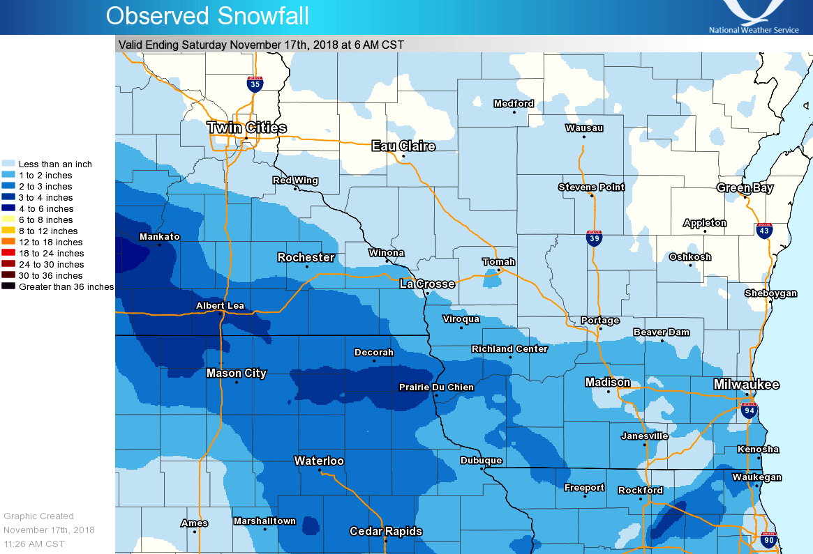
The first widespread snowfall of the winter season resulted in several inches of accumulation across much of the area during the evening hours of November 16th and early morning of the 17th. The highest totals occurred across northeast Iowa int parts of southeast Minnesota, where totals of 3 to 4 inches were reported. The highest report received came from Postville, IA near the Allamakee-Clayton County border, where 4.4" of new snow occurred. |
 Summary of snowfall totals |
Snow/Ice
Below is a list of snowfall reports from around the area. Our thanks to weather spotters and observers for sending in the reports.
A graphical version of all snow reports is also available.
Location                     Amount    Time/Date       Lat/Lon

...Iowa...

...Allamakee County...
5 NE Postville               4.4 in    0700 AM 11/17   43.14N/91.49W
Waukon                       2.0 in    0417 AM 11/17   43.27N/91.47W
4 WNW Lansing                1.8 in    0700 AM 11/17   43.40N/91.29W

...Chickasaw County...
Ionia 2W                     3.0 in    0700 AM 11/17   43.03N/92.50W
New Hampton                  2.5 in    0404 AM 11/17   43.06N/92.31W

...Clayton County...
Monona WWTP                  4.2 in    0700 AM 11/17   43.04N/91.40W
1 SSW Mcgregor               3.5 in    1000 AM 11/17   43.01N/91.19W
Edgewood                     2.8 in    0700 AM 11/17   42.65N/91.40W
Marquette                    2.6 in    0800 AM 11/17   43.05N/91.18W
Elkader                      2.0 in    0419 AM 11/17   42.85N/91.40W
Volga 1NE                    1.9 in    0645 AM 11/17   42.81N/91.52W
Elkader 6SSW                 1.7 in    0700 AM 11/17   42.78N/91.45W
Guttenberg Dam 10            1.3 in    0600 AM 11/17   42.78N/91.10W

...Fayette County...
1 ENE Alpha                  3.0 in    0900 AM 11/17   43.01N/92.03W
West Union                   2.5 in    0414 AM 11/17   42.96N/91.81W
Fayette                      2.0 in    0648 AM 11/17   42.85N/91.82W

...Floyd County...
Charles City                 3.0 in    0400 AM 11/17   43.07N/92.68W
Nora Springs 2.4 SSE         2.0 in    0700 AM 11/17   43.11N/92.99W

...Howard County...
1 SW Lourdes                 3.0 in    0855 AM 11/17   43.25N/92.32W
Elma                         2.7 in    0700 AM 11/17   43.24N/92.44W
Cresco                       2.5 in    0407 AM 11/17   43.37N/92.12W
Cresco 1NE                   2.5 in    0600 AM 11/17   43.39N/92.09W

...Mitchell County...
2 N Carpenter                4.0 in    0858 AM 11/17   43.44N/93.02W
St Ansgar                    3.8 in    0630 AM 11/17   43.38N/92.92W
Riceville                    3.8 in    0752 AM 11/17   43.36N/92.56W
Osage                        2.5 in    0402 AM 11/17   43.28N/92.81W

...Winneshiek County...
5 ESE Decorah                2.6 in    0700 AM 11/17   43.26N/91.70W
7 ENE Decorah                2.5 in    0800 AM 11/17   43.34N/91.64W
Decorah                      2.0 in    0411 AM 11/17   43.31N/91.79W

...Minnesota...

...Dodge County...
Hayfield                     2.1 in    0800 AM 11/17   43.89N/92.85W
Mantorville                  2.0 in    0452 AM 11/17   44.07N/92.75W
2 NE Kasson                  1.4 in    0700 AM 11/17   44.05N/92.72W

...Fillmore County...
1 W Fillmore                 2.8 in    0700 AM 11/17   43.74N/92.31W
Spring Valley 3E             2.4 in    0700 AM 11/17   43.68N/92.33W
1 SSE Pilot Mound            2.2 in    0700 AM 11/17   43.79N/92.03W
Lanesboro 2NE                2.1 in    0700 AM 11/17   43.73N/91.94W
Mabel                        2.0 in    0700 AM 11/17   43.52N/91.76W
Spring Valley                2.0 in    0700 AM 11/17   43.69N/92.39W
1 ESE Peterson               2.0 in    0732 AM 11/17   43.78N/91.82W
Preston                      1.5 in    0447 AM 11/17   43.68N/92.08W

...Houston County...
4 NW Eitzen                  1.8 in    0800 AM 11/17   43.56N/91.51W
Caledonia                    1.5 in    0444 AM 11/17   43.63N/91.50W
2 NE Mound Prairie           1.5 in    0706 AM 11/17   43.80N/91.43W
3 ENE Mound Prairie          1.0 in    0936 AM 11/17   43.80N/91.40W
3 W Stoddard                 0.7 in    0700 AM 11/17   43.65N/91.28W

...Mower County...
4 WSW Austin                 4.0 in    0655 AM 11/17   43.64N/93.05W
1 ENE Austin                 3.3 in    0800 AM 11/17   43.68N/92.94W
Austin                       3.0 in    0449 AM 11/17   43.67N/92.97W

...Olmsted County...
2 W Rochester                2.1 in    0723 AM 11/17   44.02N/92.51W
Rochester International Airp 2.0 in    0554 AM 11/17   43.91N/92.50W
3 SSW Predmore               2.0 in    0715 AM 11/17   43.90N/92.34W
1 ENE Rochester              1.5 in    0453 AM 11/17   44.02N/92.46W
2 NE Rochester               1.4 in    0622 AM 11/17   44.03N/92.44W
4 ESE Douglas                1.4 in    0700 AM 11/17   44.08N/92.48W
Elgin 2SSW                   1.1 in    0700 AM 11/17   44.10N/92.27W
4 ESE Douglas                1.1 in    1000 AM 11/17   44.08N/92.51W

...Wabasha County...
Theilman 1SSW                1.4 in    0730 AM 11/17   44.28N/92.19W
3 SW Zumbro Falls            1.3 in    0730 AM 11/17   44.24N/92.46W
Wabasha                      0.4 in    0730 AM 11/17   44.38N/92.03W
Wabasha                      0.3 in    0700 AM 11/17   44.38N/92.05W

...Winona County...
3 ESE Stockton               1.5 in    0830 AM 11/17   44.01N/91.71W
1 WSW Winona                 1.4 in    0715 AM 11/17   44.03N/91.68W
Winona Dam 5A                0.8 in    0600 AM 11/17   44.09N/91.67W
1 ENE Winona                 0.5 in    0458 AM 11/17   44.05N/91.64W
Minnesota City Dam 5         0.2 in    0700 AM 11/17   44.16N/91.81W
La Crescent Dam 7             T in     0600 AM 11/17   43.87N/91.31W

...Wisconsin...

...Adams County...
Friendship                   0.1 in    0700 AM 11/17   43.98N/89.83W
2 S Brooks                    T in     0700 AM 11/17   43.79N/89.64W

...Buffalo County...
Alma                         0.3 in    0410 AM 11/17   44.32N/91.91W

...Crawford County...
1 NNE Prairie Du Chien       3.2 in    0528 AM 11/17   43.05N/91.13W
Eastman                      3.0 in    0158 PM 11/17   43.16N/91.02W
Lynxville Dam 9              2.5 in    0600 AM 11/17   43.21N/91.10W
Steuben 4SE                  2.4 in    0700 AM 11/17   43.13N/90.84W
1 WNW Mount Zion             2.0 in    0700 AM 11/17   43.26N/90.76W
De Soto 1SE                  2.0 in    0700 AM 11/17   43.42N/91.19W
Gays Mills                   2.0 in    0800 AM 11/17   43.32N/90.85W
1 NNW Prairie Du Chien       1.0 in    0425 AM 11/17   43.05N/91.15W

...Grant County...
Muscoda                      2.5 in    0700 AM 11/17   43.18N/90.44W
Lancaster                    2.0 in    0423 AM 11/17   42.85N/90.71W
1 W Platteville              2.0 in    0816 AM 11/17   42.74N/90.49W
Cuba City                    1.8 in    0600 AM 11/17   42.61N/90.43W
Cuba City                    1.5 in    0930 AM 11/17   42.60N/90.43W

...Jackson County...
Black River Falls 1.7 NNE    0.4 in    0700 AM 11/17   44.32N/90.83W
Black River Falls Sewage     0.2 in    0730 AM 11/17   44.29N/90.85W
Mather 3NW                    T in     0700 AM 11/17   44.17N/90.35W

...Juneau County...
Union Center                 0.7 in    1100 AM 11/17   43.68N/90.26W

...La Crosse County...
1 SW Barre Mills             1.3 in    0700 AM 11/17   43.82N/91.13W
3 W Saint Joseph             1.1 in    0700 AM 11/17   43.78N/91.10W
NWS La Crosse                1.1 in 0430 AM 11/17 43.82N/91.19W
La Crosse Regional Airport   0.7 in    0553 AM 11/17   43.88N/91.26W

...Monroe County...
3 WNW Kendall                0.5 in    0700 AM 11/17   43.81N/90.44W
Warrens 4WSW                 0.4 in    0700 AM 11/17   44.10N/90.59W
Sparta                       0.4 in    0800 AM 11/17   43.94N/90.82W

...Richland County...
Ithaca                       2.2 in    0718 AM 11/17   43.34N/90.28W
Richland Center              2.0 in    0426 AM 11/17   43.33N/90.39W
Richland Center 4N           1.0 in    0700 AM 11/17   43.40N/90.39W

...Trempealeau County...
Trempealeau Dam 6            1.0 in    0600 AM 11/17   44.00N/91.44W

...Vernon County...
La Farge                     1.5 in    0700 AM 11/17   43.57N/90.64W
Stoddard                     1.3 in    0700 AM 11/17   43.66N/91.22W
Viroqua                      1.0 in    0429 AM 11/17   43.56N/90.88W
Genoa Dam 8                  1.0 in    0600 AM 11/17   43.57N/91.23W
Stoddard 5NNE                1.0 in    0700 AM 11/17   43.72N/91.17W
3 WNW Viola                  1.0 in    0800 AM 11/17   43.53N/90.74W
Hillsboro WSW                0.8 in    0700 AM 11/17   43.65N/90.35W
Hillsboro 2SW                0.8 in    0700 AM 11/17   43.63N/90.38W
Westby 3ENE                  0.7 in    0700 AM 11/17   43.67N/90.81W
.
 |
Media use of NWS Web News Stories is encouraged! Please acknowledge the NWS as the source of any news information accessed from this site. |
|


 Weather Story
 Weather Map
 Local Radar