Overview
|
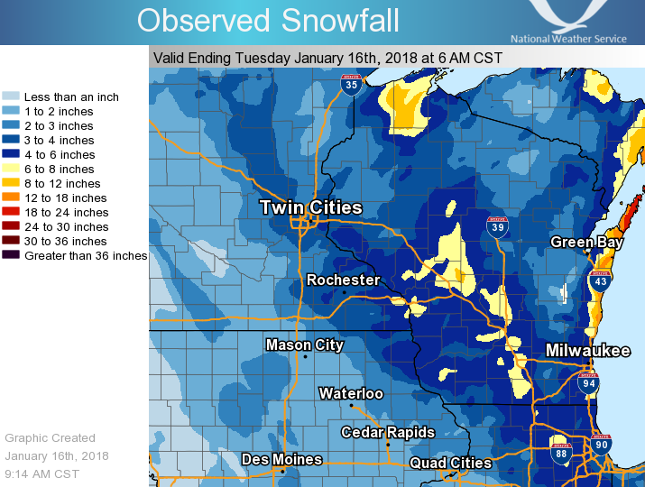
For some locations, including La Crosse, Wisconsin, this snowfall more than doubled the total snow for the winter season so far. Some minor blowing and drifting snow was noted across the open areas of southeast Minnesota and northeast Iowa, with several accidents attributed to the wintry weather. A list of snowfall reports and a snowfall map are available below, with a comprehensive regional listing of snow reports also available. |
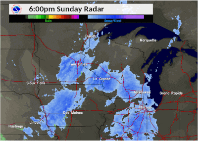 Radar loop of snow crossing the area January 14-15, 2018. |
Snow Reports
Below is a look at snowfall reports in each county as received by the National Weather Service. A graphical view of reports is available under the "Snowfall Map" tab.
Location                     Amount

Iowa Reports:

...Chickasaw County...
New Hampton                  3.3 in

...Clayton County...
Volga 1NE                    3.8 in
Monona WWTP                  3.8 in
Guttenberg Dam 10            3.1 in
Guttenberg                   3.0 in
Edgewood                     2.8 in
Strawberry Point             2.2 in

...Fayette County...
Fayette                      1.3 in

...Floyd County...
Charles City                 1.4 in

...Howard County...
Cresco 1NE                   3.6 in
Elma                         1.7 in

...Mitchell County...
Riceville                    3.3 in
St Ansgar                    2.8 in
Osage                        1.7 in

...Winneshiek County...
Decorah 7ENE                 4.3 in
Calmar NE                    4.0 in
Decorah 5ESE                 3.6 in

Minnesota Reports:

...Dodge County...
Hayfield                     3.9 in
Kasson 2NE                   3.2 in

...Fillmore County...
Mabel                        5.2 in
Peterson 1S                  4.5 in
Fillmore 1W                  3.6 in
Preston                      3.1 in
Spring Valley                3.0 in

...Houston County...
Mound Prairie 3ENE           5.3 in
Caledonia                    4.9 in
La Crescent                  4.3 in

...Mower County...
Austin                       2.0 in
Grand Meadow                 3.0 in

...Olmsted County...
Predmore 2SSW                4.3 in
Byron 4N                     4.1 in
Rochester 2SSE               4.0 in
Douglas 3ESE                 4.0 in
Rochester Intl Airport       4.0 in
Elgin 2SSW                   3.2 in

...Wabasha County...
Zumbro Falls 5NNE            5.0 in
Wabasha 1NNE                 4.5 in
Wabasha 1N                   4.5 in
Lake City                    4.0 in
Wabasha                      3.8 in
Zumbro Falls 3SW             3.7 in
Theilman 1SSW                3.4 in

...Winona County...
Wilson 2NW                   7.0 in
Winona 4SW                   7.0 in
La Crescent Dam 7            5.0 in
Winona Dam 5A                4.6 in
Minnesota City Dam 5         3.7 in
1 WSW Winona                 3.7 in

Wisconsin Reports:

...Adams County...
Friendship                   2.2 in

...Buffalo County...
Alma Dam 4                   4.5 in

...Clark County...
Owen 6SSE                    6.0 in

...Crawford County...
Prairie Du Chien             7.2 in
De Soto 1SE                  7.0 in
Lynxville Dam 9              6.0 in
Steuben 4SE                  4.4 in

...Grant County...
Platteville                  5.0 in
Cuba City                    3.0 in

...Jackson County...
Black River Falls            4.2 in

...Juneau County...
Mauston 1SE                  4.0 in

...La Crosse County...
La Crosse Weather Office     6.9 in
La Crosse Regional Airport   6.8 in
La Crosse 4NNW               6.5 in
West Salem                   6.0 in
Holmen 2S                    5.9 in

...Monroe County...
Warrens 4WSW                 5.5 in
Four Corners                 5.3 in
Cashton 3NNW                 4.4 in
Kendall 3WNW                 3.1 in
Sparta                       2.5 in

...Richland County...
Ithaca 1WSW                  4.5 in
Ithaca 1W                    4.5 in

...Trempealeau County...
Ettrick 4WNW                 5.3 in
Trempealeau Dam 6            5.0 in
Galesville                   4.0 in
Independence                 3.0 in

...Vernon County...
Coon Valley 2W               6.0 in
Stoddard 5NNE                5.4 in
Stoddard 3NE                 4.7 in
Viroqua                      4.6 in
Viroqua 1ESE                 4.5 in
Stoddard                     4.4 in
La Farge                     3.8 in
Westby 3ENE                  3.7 in
Hillsboro                    3.5 in
Snowfall Map:
Total snowfall of 2 to 7 inches was observed across the area, with much higher amounts over 1 foot across portions of the Door Peninsula near Lake Michigan.
 |
|||
| Map of 2-day total snowfall |
 |
Media use of NWS Web News Stories is encouraged! Please acknowledge the NWS as the source of any news information accessed from this site. |
|


 Weather Story
 Weather Map
 Local Radar