Overview
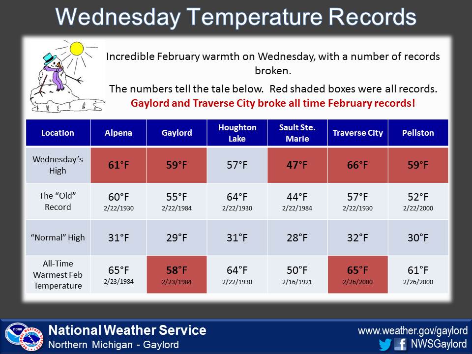
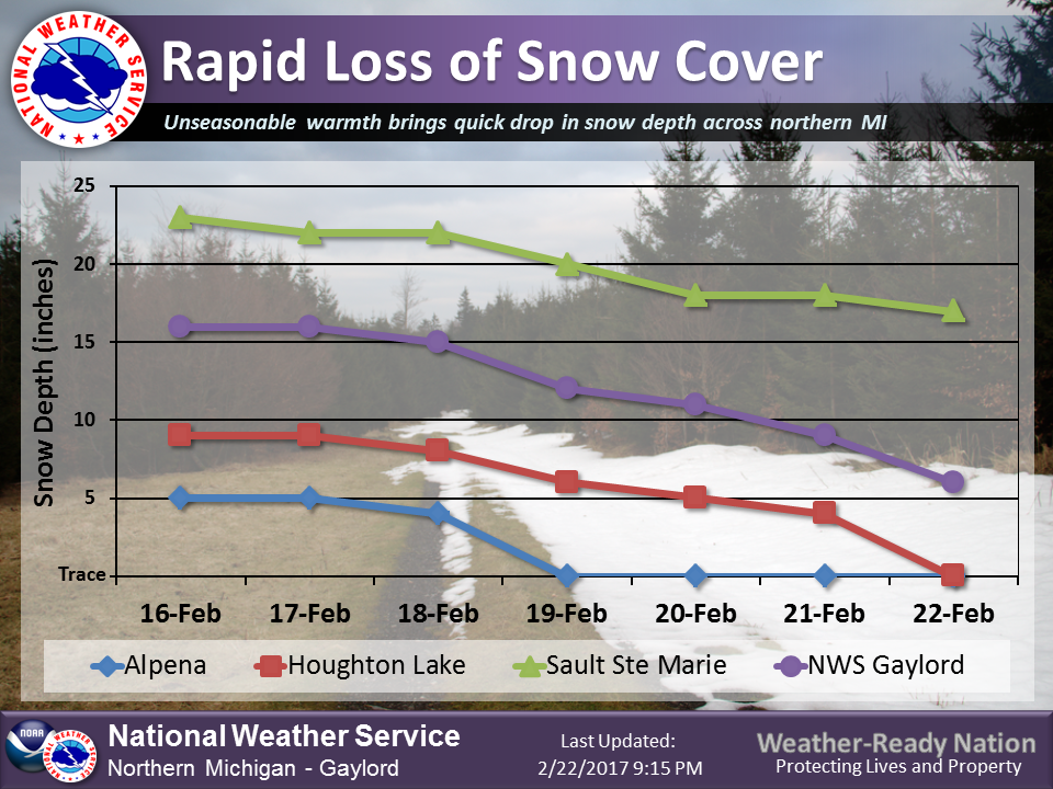
February 22nd, 2017 will be remembered for being one of the warmest February days in the recorded climate history of northern Michigan. A number of daily records were broken, with Traverse City and Gaylord setting all time February temperature records. The snow pack was melted away in most areas, with outdoor winter activities such as cross country skiing and snowmobiling coming to an abrupt stop.
Eastern Upper/Northern Lower Michigan Temperature and Precip Summary
National Weather Service Gaylord MI
1157 AM EST THU FEB 23 2017

Yesterday`s High Temperature...12 hour Low ending 7 am EST
24 hour Precipitation/Snowfall ending 7 am EST
Snow Depth observed at 7 am EST

.BR APX 0223 ES DH00/TAIRZX/DH07/TAIRZP/PPDRZZ/SFDRZZ/SDIRZZ
:..................................................................
:                         MAX   MIN   24 HR   24 HR  SNOW
:ID    LOCATION           TEMP  TEMP  PRECIP  SNOW   DEPTH
:..................................................................
ANJ : Sault Ste Marie   :  47 /  36  / 0.55 /  0.0 / 15.0
APN : Alpena            :  61 /  42  / 0.01 /  0.0 /  0.0
HTL : Houghton Lake     :  58 /  43  / 0.00 /  0.0 /  0.0
PLN : Pellston          :  59 /  36  / 0.08 /      /
TVC : Traverse City     :  66 /  38  / 0.00 /      /
GLR : Gaylord           :  59 /  38  / 0.01 /      /
.END

Cooperative Observations
Temperature/Precipitation/Snowfall values are for 24 hour period
ending at observation time. Snow Depth at obs time.

...................................................................
                              OBS    MAX   MIN          SNOW  SNOW
ID      LOCATION              TIME   TEMP  TEMP  PCPN   FALL  DEPTH
...................................................................
ATLM4: Atlanta 1SW          :DH0700/  58 /  34 /    T / 0.0 /   T
BEUM4: Beulah 7SSW          :DH0800/  63 /  36 /    T /   M /   T
CADM4: Cadillac             :DH0800/  58 /  38 / 0.00 /   M /   M
CHRM4: Charlevoix           :DH0800/  59 /  35 / 0.22 / 0.0 /   M
DTVM4: Detour Village       :DH0800/  46 /  32 / 0.01 / 0.0 / 2.0
EJNM4: East Jordan 2NW      :DH0900/  61 /  36 / 0.37 / 0.0 / 4.0
ETWM4: East Tawas           :DH0830/  57 /  38 / 0.00 / 0.0 / 0.0
ENGM4: Engadine MDOT        :DH0700/  47 /  33 / 0.24 / 0.0 /   T
FLAM4: Fife Lake 2WSW       :DH0700/  60 /  35 / 0.00 / 0.0 / 0.0
GAYM4: Gaylord              :DH0800/  60 /  34 / 0.02 / 0.0 / 5.0
APXM4: Gaylord 9SSW (NWS)   :DH0700/   M /   M / 0.02 / 0.0 / 2.0
GLAM4: Gladwin              :DH0700/  62 /  34 / 0.00 / 0.0 / 0.0
GLNM4: Glennie 2SE          :DH0730/  54 /  38 / 0.00 / 0.0 / 0.0
HALM4: Hale Loud Dam        :DH0900/  56 /  38 / 0.00 / 0.0 / 0.0
HRSM4: Harrisville 2NNE     :DH0800/  57 /  36 / 0.00 / 0.0 / 0.0
LKCM4: Lake City 2SE        :DH0800/  59 /  36 / 0.00 / 0.0 / 0.0
LEWM4: Lewiston 3W          :DH0800/  54 /  36 /    T / 0.0 / 4.0
LUPM4: Lupton 1S            :DH0800/  54 /  31 /    T / 0.0 /   T
MYOM4: Mio                  :DH0830/  57 /  40 / 0.00 / 0.0 / 1.0
MRAM4: Moran                :DH0800/  51 /  34 / 0.11 / 0.0 / 2.0
OMSM4: Old Mission 3SSW     :DH0800/  63 /  36 /    T /   M /   M
PTYM4: Petoskey NCMC        :DH0800/  63 /  33 / 0.16 / 0.0 / 0.0
RGCM4: Rogers City          :DH0800/  60 /  38 / 0.49 / 0.0 / 0.0
SSMM4: Sault Ste Marie      :DH0800/  48 /  34 / 0.70 /   M /15.0
STIM4: St Ignace            :DH0700/  47 /  33 / 0.19 / 0.0 /   T
STAM4: Standish             :DH0800/  59 /  34 / 0.00 / 0.0 / 0.0
NWFM4: Traverse City 8NNW   :DH0800/  62 /  37 /    T / 0.0 / 0.0
TCMM4: Traverse City MUNSON :DH0730/  65 /  37 / 0.00 / 0.0 / 0.0
 |
 |
| February 22, 2017 Records (NWS Gaylord) |
Caption (source) |
 |
Media use of NWS Web News Stories is encouraged! Please acknowledge the NWS as the source of any news information accessed from this site. |
 |