Gaylord, MI
Weather Forecast Office
For a more in-depth view of the meteorology and damage behind the historic EF-3 Gaylord, MI tornado, visit this page.
Overview
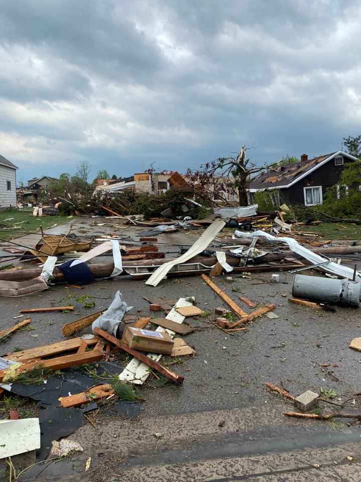
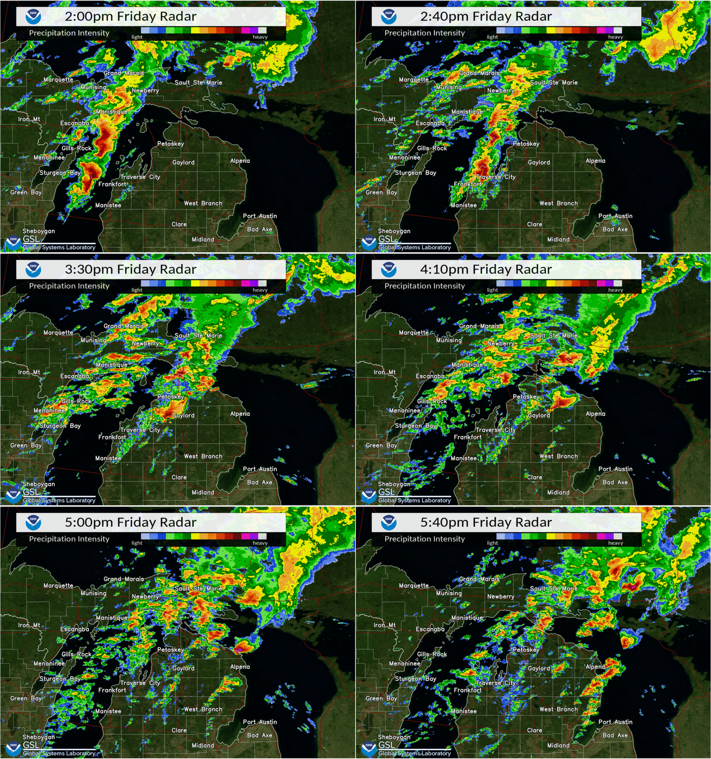
Multiple thunderstorms tracked across northern Michigan during the afternoon, including a supercell thunderstorm that produced the tornado that hit the town of Gaylord along with very large hail in other parts of the area.
Setting the stage for severe weather was a trough that rotated across the upper Midwest that developed and strengthened surface low pressure west of Lake Michigan. This system helped draw a warm, moist airmass northward across the state that helped provide the instability necessary to support severe thunderstorms later in the day. Storms initially formed along the cold front across Wisconsin during the morning hours and moved northeast across Lake Michigan, making it into the forecast area by early afternoon. The strongest line segment generated a measured wind gust of 76 mph at Frankfort Light and continued to produce damaging wind gusts across Leelanau and Antrim counties as it quickly moved northeast.
As this segment moved further away from the cold front, it began to transition into a supercell thunderstorm. This storm moved east-northeast across a very favorable environment in place across northern lower Michigan, eventually producing a tornado that caused considerable damage in the city of Gaylord. This supercell continued to trek across the area, producing baseball-sized hail in Posen.
A special weather balloon launch was conducted at 3 PM EDT to get a better look at the environment in place ahead of the approaching storm. The data from this balloon launch displayed a rare environment in place that was supportive of storms producing damaging wind gusts, very large hail, and tornadoes. Specifically, the data showed ample instability in place. This is measured by a variable called Convective Available Potential Energy (CAPE), where values were near 2,000 Joules/kilogram. Very strong wind shear was also in place, which is a measure of the change in wind speed and direction with height in the atmosphere. Almost 60 knots of shear was measured from the surface to 6 km above ground level. Storm-relative helicity (SRH), a variable that shows the tendency of the air being drawn into the storm to spin, had values of almost 300 meters^2/second^2. The magnitude of all of these variables are very high, supportive for supercell thunderstorm development and severe weather. Additionally, it is very rare for this magnitude of all of these variables to come together at once across northern Michigan.
|
Tornado: Gaylord
|
||||||||||||||||
 |
 |
 |
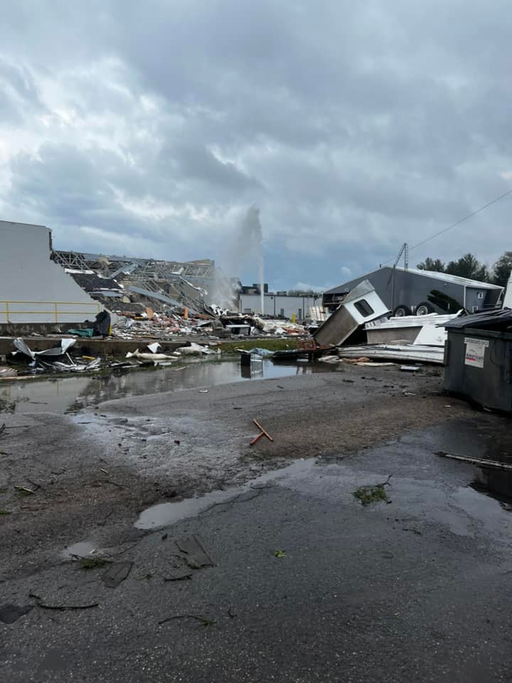 |
| Tornado damage in Gaylord- Photo credit Marcy Maciag Bancroft | Tornado damage in Gaylord at Hobby Lobby and Jimmy John's- Photo credit Arica Alread | Tornado damage in Gaylord at Goodwill- Photo credit Kyle Piers | Extensive damage at the Hobby Lobby in Gaylord- Photo credit Melissa Davison |
The Enhanced Fujita (EF) Scale classifies tornadoes into the following categories:
| EF0 Weak 65-85 mph |
EF1 Moderate 86-110 mph |
EF2 Significant 111-135 mph |
EF3 Severe 136-165 mph |
EF4 Extreme 166-200 mph |
EF5 Catastrophic 200+ mph |
 |
|||||
Hail:
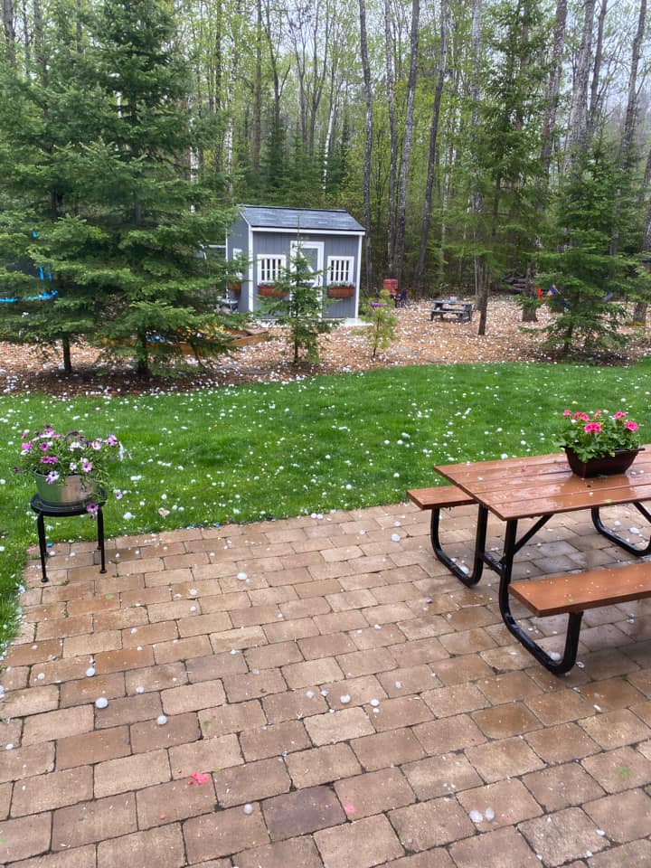
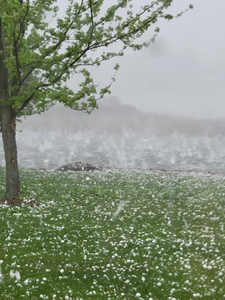
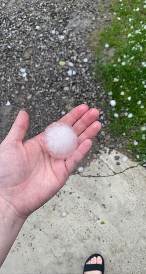
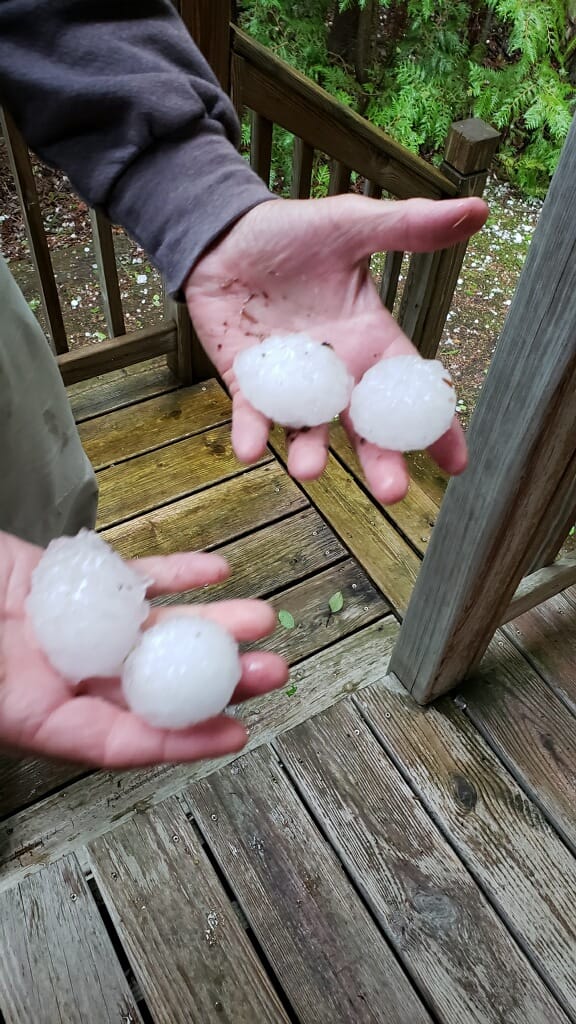
Large hail accompanied these storms with the largest hail stones ranging from the size of quarters (1.00") to slightly larger than baseballs (3.00").
 |
 |
 |
 |
| Large hail in Elmira, Otsego County. Photo courtesy of Christopher Weber | Large Hail in Presque Isle County. Photo courtesy of Stephanie Adamski | Large Hail in Presque Isle County. Photo courtesy of Courtney Dege | Large hail in Hawks, Presque Isle County. Photo courtesy of Cheryl Blade |
 |
 |
 |
 |
| Large hail on Grand Lake, Presque Isle County. Photo courtesy of Mary Brunette Taglarini | Large hail in Presque Isle. Photo courtesy of Cassie Helms. | Large hail on Grand Lake, Presque Isle County. Photo courtesy of Mary Brunette Taglarini | Large hail in Grand Lake, Presque Isle County. Photo courtesy of Becky Meyer |
Radar:
KAPX Doppler Radar loop from 2:00 PM through 5:40 PM EDT on May 20th.
 |
Storm Reports
.png)
..TIME...   ...EVENT...      ...CITY LOCATION...     ...LAT.LON...
..DATE...   ....MAG....      ..COUNTY LOCATION..ST.. ...SOURCE....
            ..REMARKS..

0314 PM     TSTM WND DMG     CENTRAL LAKE            45.07N 85.26W
05/20/2022                   ANTRIM             MI   PUBLIC

            SCANNER REPORTS CREWS ARE ON THE SCENE OF A
            TREE BLOCKING A ROADWAY NEAR CENTRAL LAKE.
            TIME ESTIMATED BY RADAR.

0316 PM     TSTM WND DMG     BELLAIRE                44.98N 85.21W
05/20/2022                   ANTRIM             MI   PUBLIC

            REPORTS OF TREES AND WIRES DOWN IN BELLAIRE.
            TIME ESTIMATED FROM RADAR.

0337 PM     HAIL             2 W ELMIRA              45.06N 84.89W
05/20/2022  E1.75 INCH       ANTRIM             MI   PUBLIC

            FACEBOOK PHOTO OF GOLF BALL SIZED HAIL AT
            THE INTERSECTION OF M-32 AND US 131. TIME
            ESTIMATED BY RADAR.

0339 PM     TSTM WND DMG     4 SSW ELMIRA            45.01N 84.87W
05/20/2022                   ANTRIM             MI   PUBLIC

            SCANNER REPORTS TREES DOWN ON PATERSON ROAD
            NEAR ALBA HWY. POSSIBLE TORNADO. TIME
            ESTIMATED BY RADAR.

0339 PM     HAIL             ELMIRA                  45.06N 84.85W
05/20/2022  E2.00 INCH       OTSEGO             MI   PUBLIC

            FACEBOOK PHOTO OF A LARGE HAILSTONE IN
            ELMIRA. TIME ESTIMATED BY RADAR.

0348 PM     TORNADO          2 W GAYLORD             45.03N 84.70W
05/20/2022                   OTSEGO             MI   NWS EMPLOYEE

            TORNADO SPOTTED BY NWS EMPLOYEE NEAR THE
            INTERSECTION OF M-32 AND MURNER ROAD.

0353 PM     TORNADO          2 W SPARR               45.04N 84.62W
05/20/2022                   OTSEGO             MI   NWS EMPLOYEE

            TORNADO SPOTTED BY NWS EMPLOYEE 1 MILE E OF
            GAYLORD AT APPROXIMATELY 3:53PM.

0415 PM     HAIL             4 N CLEAR LAKE STATE PA 45.20N 84.19W
05/20/2022  E1.50 INCH       PRESQUE ISLE       MI   PUBLIC

            FACEBOOK PHOTO OF 1.50 INCH HAIL AT TOMAHAWK
            CREEK FLOODING. TIME ESTIMATED ON RADAR.

0438 PM     HAIL             HAWKS                   45.30N 83.90W
05/20/2022  E2.00 INCH       PRESQUE ISLE       MI   PUBLIC

            TIME ESTIMATED BY RADAR.

0445 PM     HAIL             POSEN                   45.26N 83.70W
05/20/2022  E2.75 INCH       PRESQUE ISLE       MI   PUBLIC

            BASEBALL SIZED HAIL REPORTED IN POSEN.

0457 PM     HAIL             3 WNW PRESQUE ISLE      45.31N 83.52W
05/20/2022  E2.00 INCH       PRESQUE ISLE       MI   PUBLIC

            REPORT OF HEN EGG SIZED HAIL IN BLACK BASS
            BAY. TIME ESTIMATED BY RADAR.

0230 PM     TSTM WND DMG     GLEN ARBOR              44.89N 85.99W
05/20/2022                   LEELANAU           MI   LAW ENFORCEMENT

            COUNTY DISPATCH REPORTED TREE DOWN BLOCKING
            S. GLEN LAKE RD. TIME ESTIMATED VIA RADAR.

0235 PM     TSTM WND DMG     3 SSE LELAND            44.98N 85.73W
05/20/2022                   LEELANAU           MI   LAW ENFORCEMENT

            TREE DOWN BLOCKING POP RD. TIME ESTIMATED
            VIA RADAR.

0325 PM     HAIL             4 W ALBA                44.98N 85.05W
05/20/2022  E1.00 INCH       ANTRIM             MI   PUBLIC

            DELAYED REPORT OF 1IN HAIL 4MI WEST OF ALBA.

0345 PM     HAIL             5 NW GAYLORD            45.09N 84.75W
05/20/2022  E1.00 INCH       OTSEGO             MI   PUBLIC

            DELAYED REPORT... QUARTER SIZED HAIL 5MI NW
            OF GAYLORD.

0349 PM     HAIL             2 E VANDERBILT          45.14N 84.63W
05/20/2022  E0.88 INCH       OTSEGO             MI   PUBLIC

            DELAYED REPORT OF NICKEL SIZED HAIL IN
            CORWITH TWP VIA FACEBOOK. TIME ESTIMATED BY
            RADAR.

0358 PM     HAIL             HESSEL                  46.01N 84.42W
05/20/2022  E1.75 INCH       MACKINAC           MI   PUBLIC

            DELAYED REPORT OF GOLF BALL SIZED HAIL IN
            HESSEL. TIME ESTIMATED BY RADAR.

0450 PM     HAIL             2 NNW PRESQUE ISLE      45.33N 83.49W
05/20/2022  E3.00 INCH       PRESQUE ISLE       MI   PUBLIC

            DELAYED REPORT OF 3IN HAIL NEAR PRESQUE
            ISLE.

0229 PM     TSTM WND GST     1 SW FRANKFORT          44.63N 86.25W
05/20/2022  M76 MPH          LMZ346             MI   MESONET

            MESONET STATION XFLT FRANKFORT LIGHT.
 |
Media use of NWS Web News Stories is encouraged! Please acknowledge the NWS as the source of any news information accessed from this site. |
 |
Local Information
Area Information
Office Webcam
Forecast
Recreational
Great Lakes/Marine
NWS DSS Table
Beach/Surf
Text Products
US Dept of Commerce
National Oceanic and Atmospheric Administration
National Weather Service
Gaylord, MI
8800 Passenheim Road
Gaylord, MI 49735-9454
989-731-3384
Comments? Questions? Please Contact Us.

