
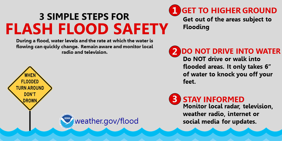
Tropical Depression Two is expected to gradually strengthen and could bring tropical storm conditions to the Florida Panhandle beginning late Monday. Areas of flash flooding will be possible through Thursday along the eastern and central Gulf Coast. Severe thunderstorms will develop and move along a cold front crossing the Upper Midwest Monday, and through the Ohio Valley/Mid-Atlantic on Tuesday. Read More >
| Southern Utah Flash Flood Potential Rating Click here for previous ratings |
Quick Look Utah RADAR |
 RADAR: Salt Lake City | Cedar City | Grand Junction move mouse over links to change image |
Arches N.P. Visitor Center
Balanced Rock
Devil's Garden
Bryce Canyon N.P. Visitor Center
Rainbow Point
Canyonlands N.P. Visitor Center
Hans Flat Ranger Station
Island in the Sky Visitor Center
Needles Visitor Center
Capitol Reef N.P. Visitor Center
Cathedral Valley Campground
Halls Creek Overlook
Antelope Point
Bullfrog Basin
Dangling Rope
Coyote Gulch
Halls Crossing
Hans Flat
Hite
Wahweap
Big Water Visitor Center
Buckskin Gulch/Wire Pass
Cannonville Visitor Center
Escalante Interagency Visitor Center
Kanab Visitor Center
Paria Contact Station
Peek-A-Boo Gulch/Spooky Gulch
Goblin Valley State Park
Little Wildhorse/Bell Canyon Trailhead
Timpanogos Cave System Entrance
Timpanogos Cave Visitor Center
Zion N.P. Visitor Center
Zion Canyon
Zion Headwaters
Zion Plateau

