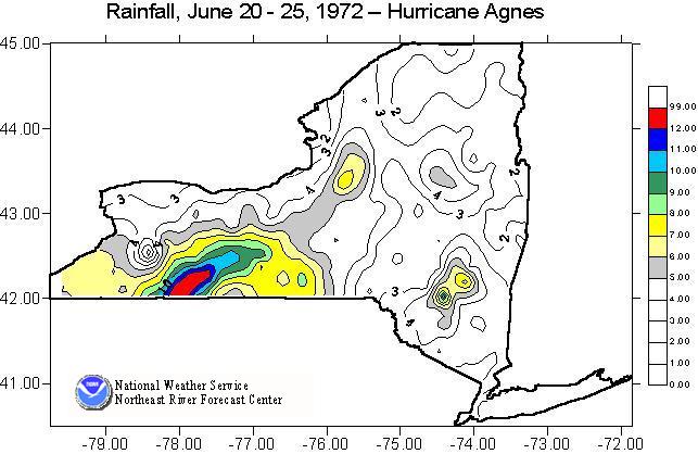
The most destructive, widespread flooding to occur in the eastern United States occurred in June 1972 as a result of Hurricane Agnes. Unlike some other flood producing hurricanes in the northeast, Agnes was not a particularly strong hurricane. In fact, most of its devastation occurred well after it had been downgraded to a tropical storm. Agnes originated in the Gulf of America and slowly moved up the east coast before moving northwest across Pennsylvania and the southern tier of New York state. At this point, the remnants of Agnes joined another large low pressure system and continued to produce heavy rains.
The most significant destruction caused by Agnes, occurred in the Susquehanna River basin in Pennsylvania. This is well documented by the NWS Middle Atlantic River Forecast Center. This description will focus instead on the impacts on the Genesee River basin in western New York.
During the week prior to Agnes, a large amount of shower activity resulted in widespread areas of over an inch of rain. Heavy rain from Agnes started on the night of June 20 and continued until the 25th of June. Over the Genesee River basin, the maximum official rainfall amount recorded was 13.7 inches at Wellsville NY. Unofficial reports of over 16 inches were also received.
On the upper Genesee, above Mt Morris Dam, flooding was devastating breaking all historical records. Both of the official river stage gages -- at Scio and Wellsville -- were destroyed by the flooding. Hundreds of roads and bridges were washed out by the flood waters. One significant factor in the damage was the large amount of debris flow that moved downstream which caused significant scour and damming along various parts of the stream channel. The Wellsville area was the hardest hit in the Genesee basin as a portion of Jones Memorial Hospital was destroyed by the flood.
The lower Genesee mainstem, from Mt Morris to Rochester, was spared the worst of the flooding primarily due to the operations of the dam. During the early part of the event, there was significant concern of overtopping the spillway or having to release such major amounts of water as to cause major downstream flooding. Overtopping would have been catastrophic in terms of flow, but also would have allowed significant debris that was caught by the dam to be released downstream. However, close monitoring and careful releases resulted in flooding downstream but not nearly to the impact that could have occurred. Maximum inflow to the reservoir was about 90,000 cfs; however, the outflow was limited to just over 15,000 cfs. While downstream damage did occur, the Corps of Engineers estimated that the dam operations during Agnes alone prevented over $200 million of additional potential damage.
Downstream flooding was also contributed to by tributaries, such as the Canaseraga Creek. Downstream of Dansville, flood levees were overtopped. The levees, which were designed to protect agricultural land, wound up causing problems since it took nearly all summer to drain the fields following the flooding.

| River | Location | Flow | cfs/sq mile | Stage |
|---|---|---|---|---|
| Genesee | Wellsville | 38,500 cfs | 134 csm | 20.7 ft * |
| Genesee | Portageville | 90,000 cfs | 91 csm | 35.2 ft * |
| Genesee | Avon | 16,500 cfs | 10 csm | 40.7 ft * |
Note: * represents flood of record