Catastrophic Super Typhoon Bavi's eyewall has reached Rota and is expected to bring dangerous winds, heavy rainfall and storm surge to Guam, Rota, Tinian and Saipan. A Typhoon Warning remains in effect. Heavy to excessive rainfall will continue to bring a flooding threat from coastal Mid-Atlantic to southern New England through Monday. Read More >
A slow-moving cold front coupled with unseasonably abundant atmospheric moisture from the Gulf of America provided the impetus for a prolonged heavy rainfall event over southern Wisconsin. Storm total rainfall amounts over the area generally ranged from 2-5 inches, with locally higher amounts reported in some spots.
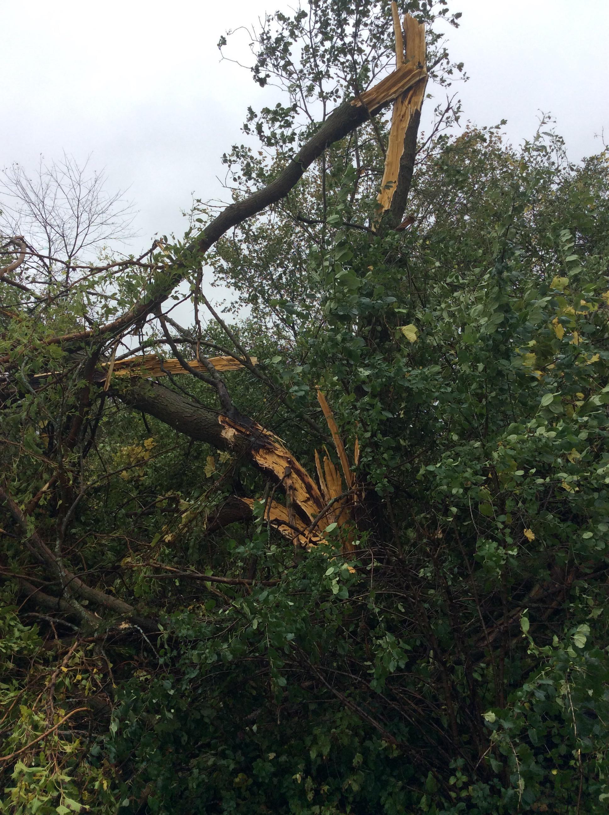
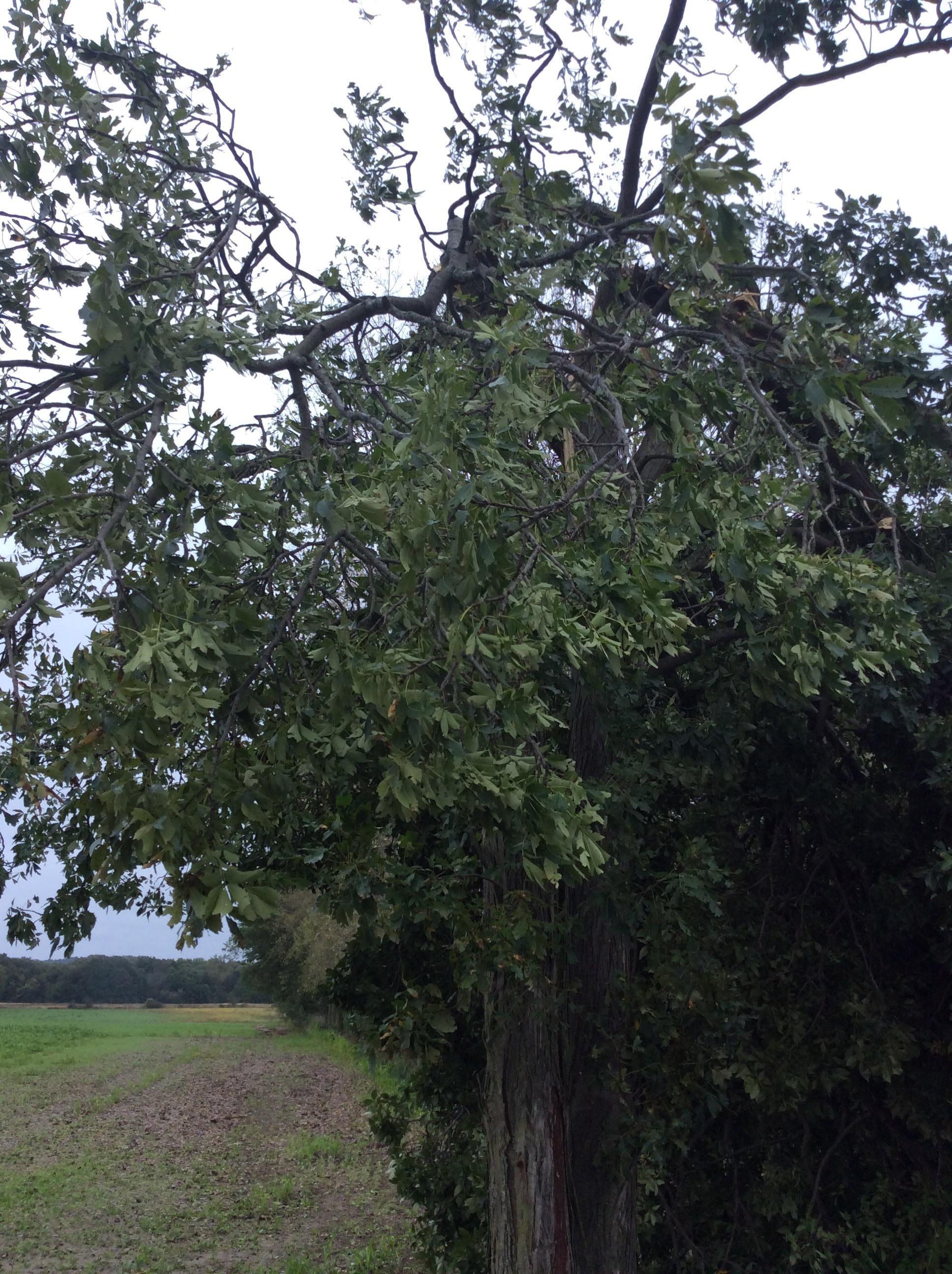
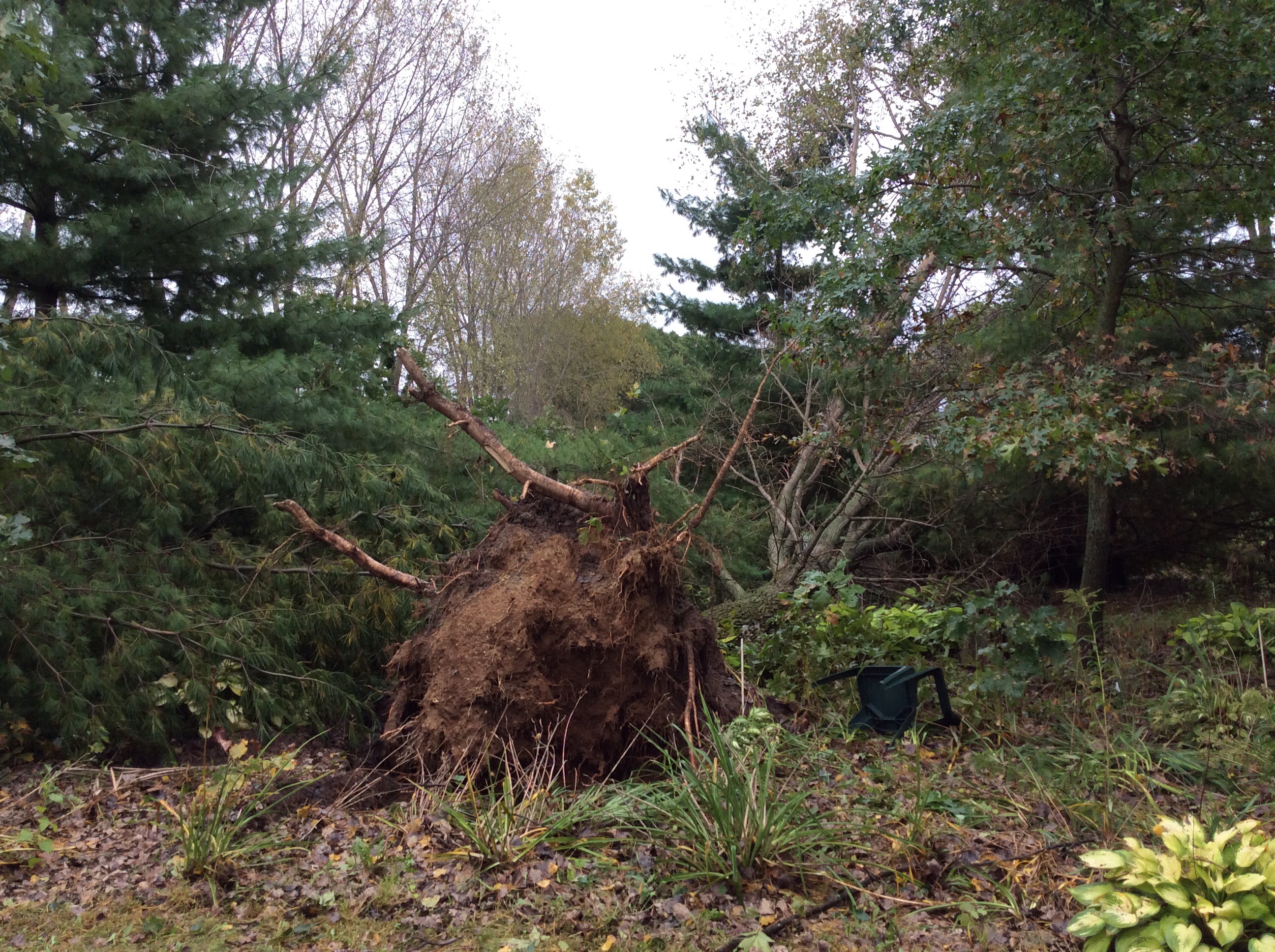
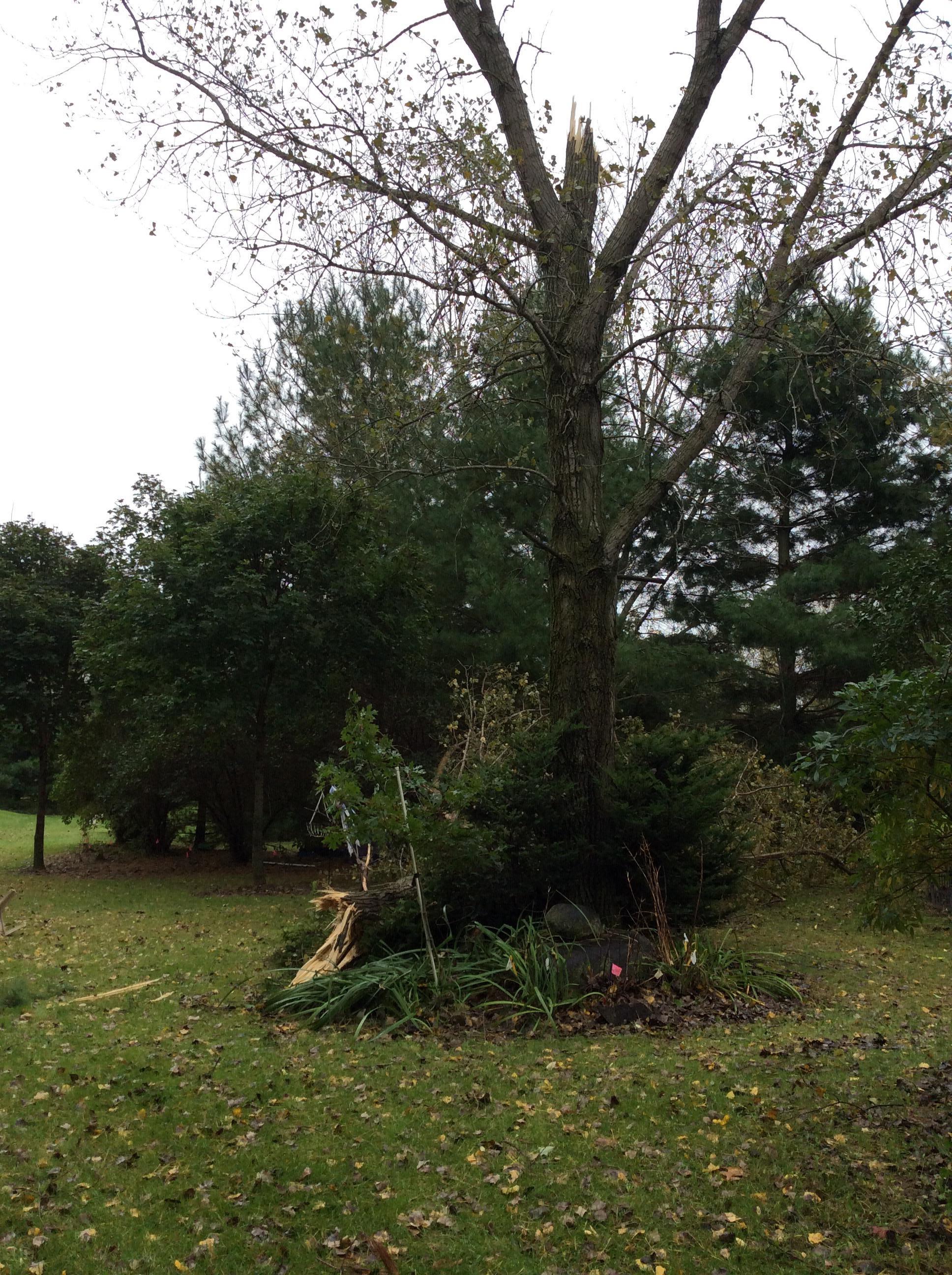
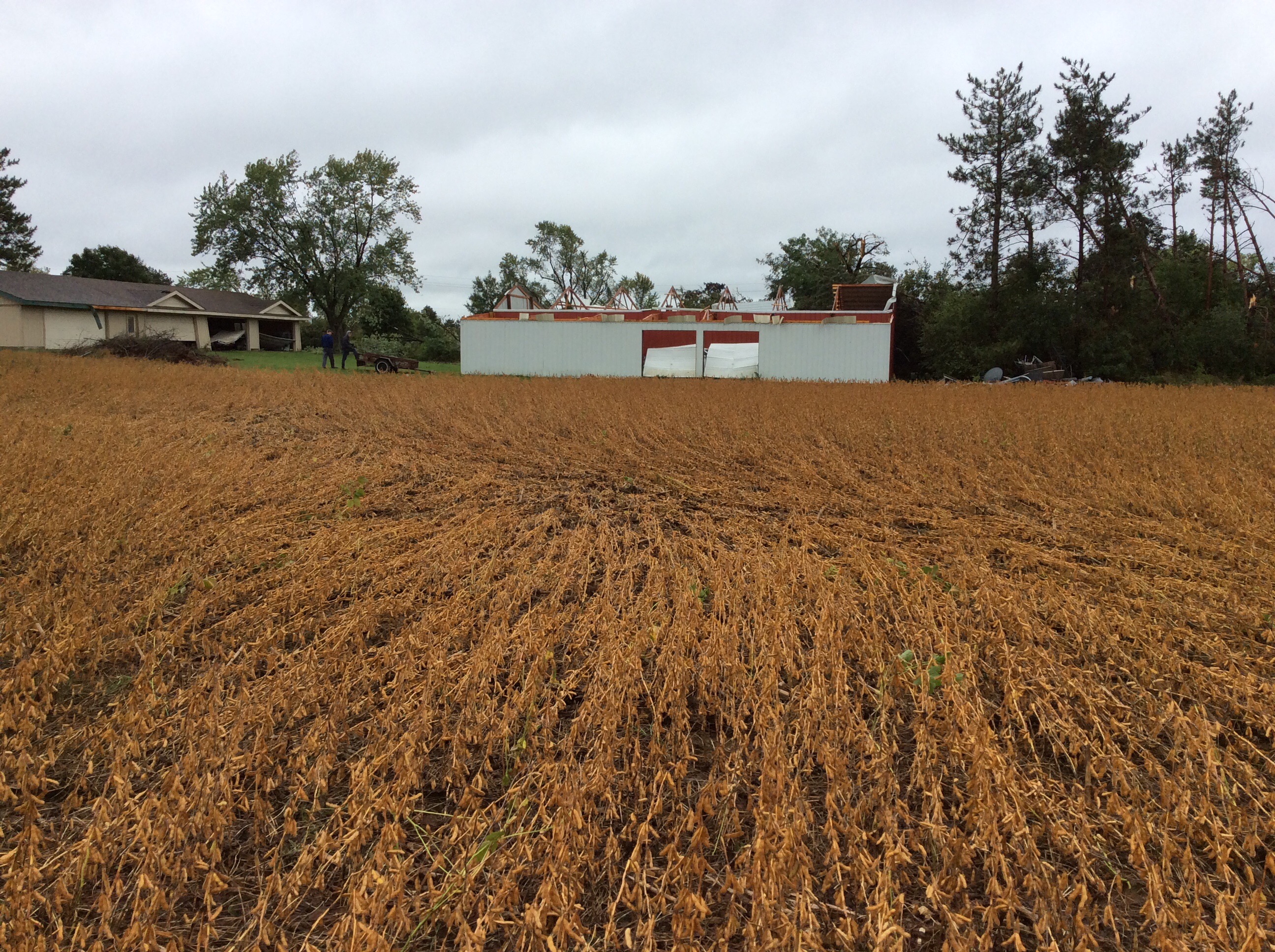
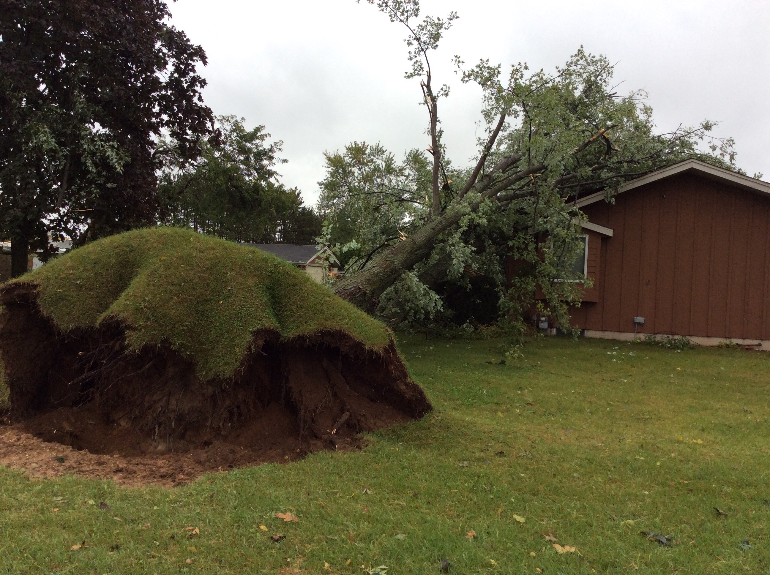
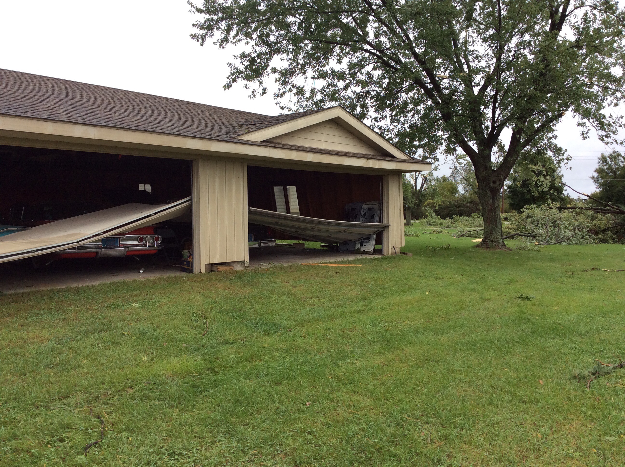
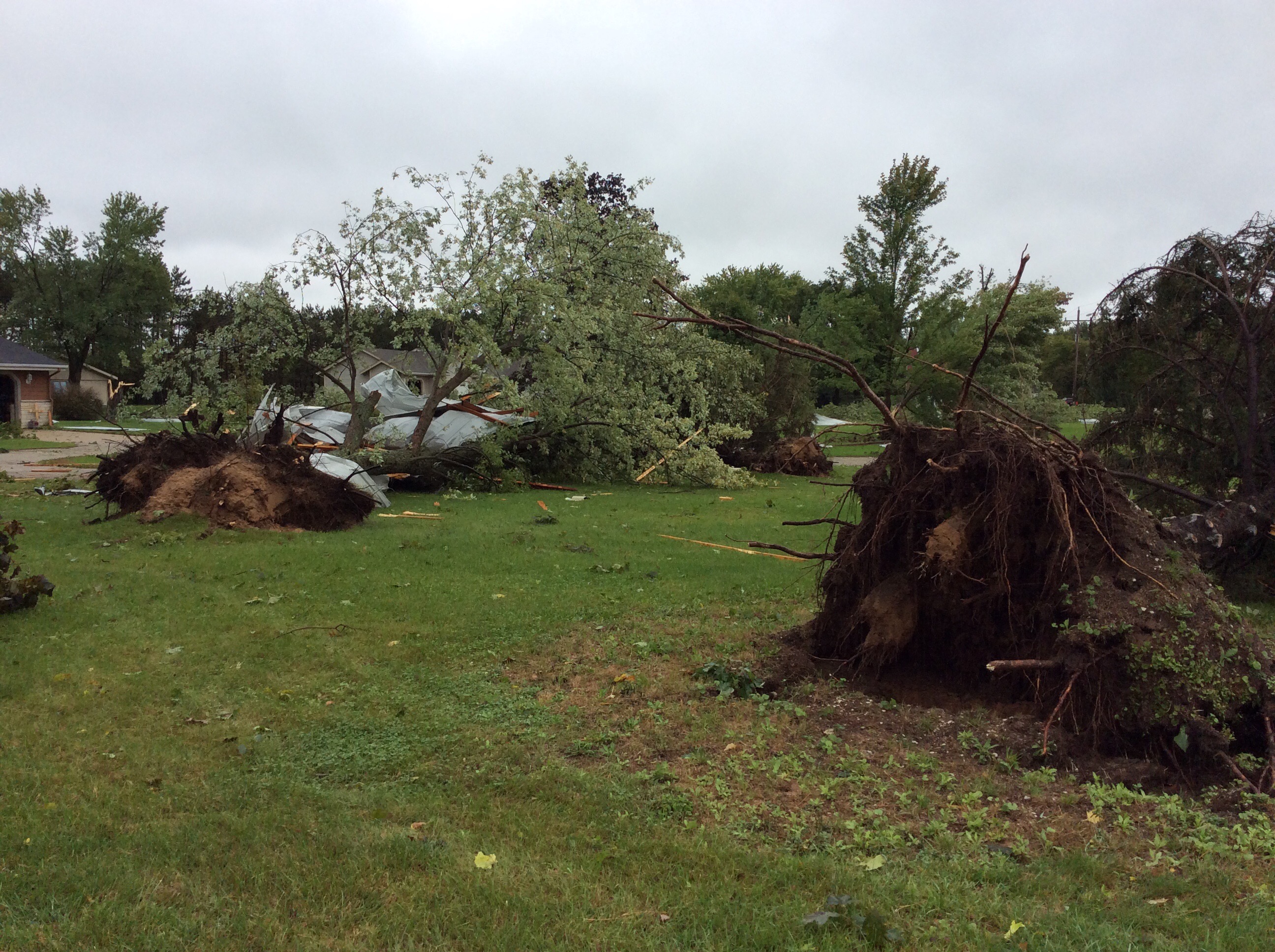
Additionally, severe weather moved across the area the evening of October 1st, causing damage in the areas of Belleville, Fort Atkinson, Blanchardville, and south of Sullivan through the Genesee Depot area. The following is an overview of these events.
__________________________________________________________________________________________________________________________
Severe Weather and Storm Damage
After the first round of storms, sufficient clearing allowed for thunderstorm redevelopment. The second round of storms initiated around the 4 to 5 pm time frame and expanded in coverage through the evening. There was enough instability and shear available for storms to become severe with the potential for damaging winds, hail, and tornadoes. As the line of storms developed and moved eastward a few periods of gusty winds and a couple areas of rotation developed. There are currently two confirmed tornadoes from the evening on October 1st. More information can be found below.
Tornadoes: Click here for a more detailed viewer of the track maps
|
Tornado - Fort Atkinson
Track Map 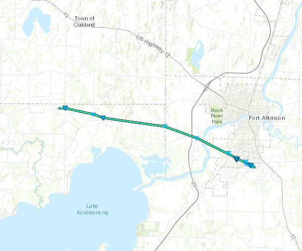 
Downloadable KMZ File |
||||||||||||||||
|
||||||||||||||||
|
Tornado - Rome to Ottawa
Track Map 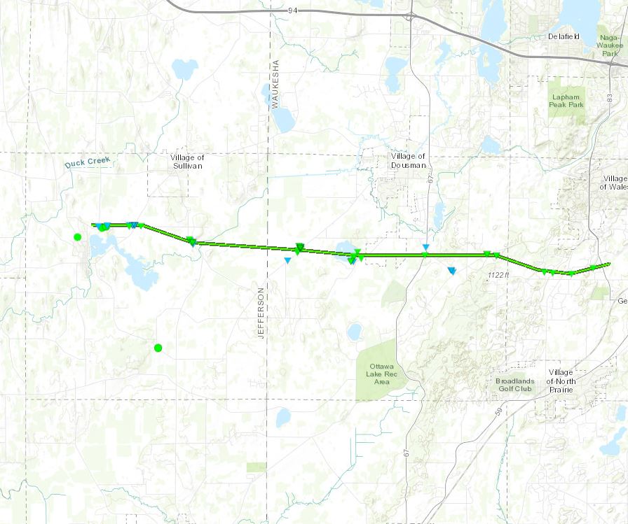
Downloadable KMZ File |
||||||||||||||||
|
||||||||||||||||
The Enhanced Fujita (EF) Scale classifies tornadoes into the following categories:
| EF0 Weak 65-85 mph |
EF1 Moderate 86-110 mph |
EF2 Significant 111-135 mph |
EF3 Severe 136-165 mph |
EF4 Extreme 166-200 mph |
EF5 Catastrophic 200+ mph |
 |
|||||
Radar:
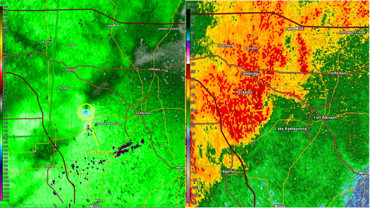 |
| Fort Atkinson Tornado, Radar Image at 9:25 pm on October 1st (Click to Enlarge) |
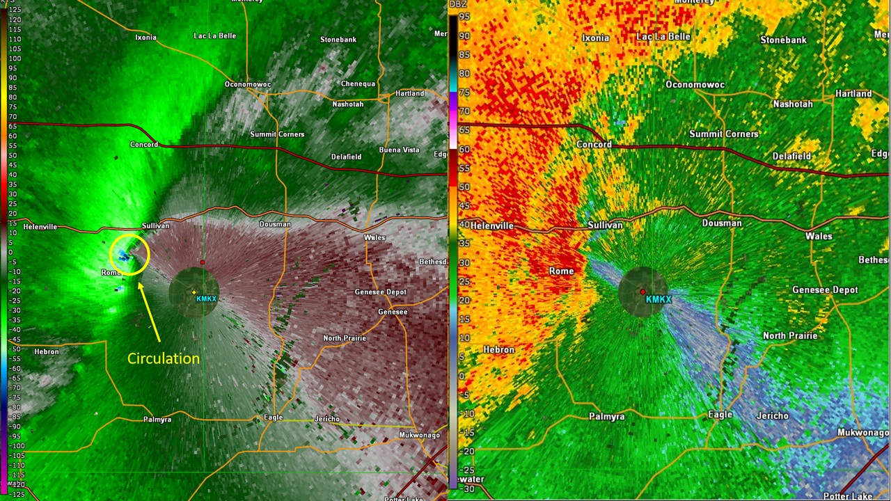 |
| Tornado in Rome, Radar Image at 9:42 pm on October 1st (Click to Enlarge) |
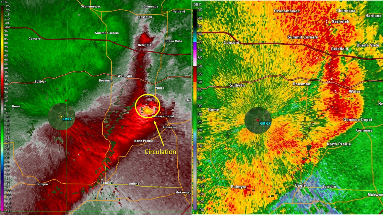 |
| Tornado near Genesee Depot, Radar Image at 9:54 pm on October 1st (Click to Enlarge) |
Storm Reports
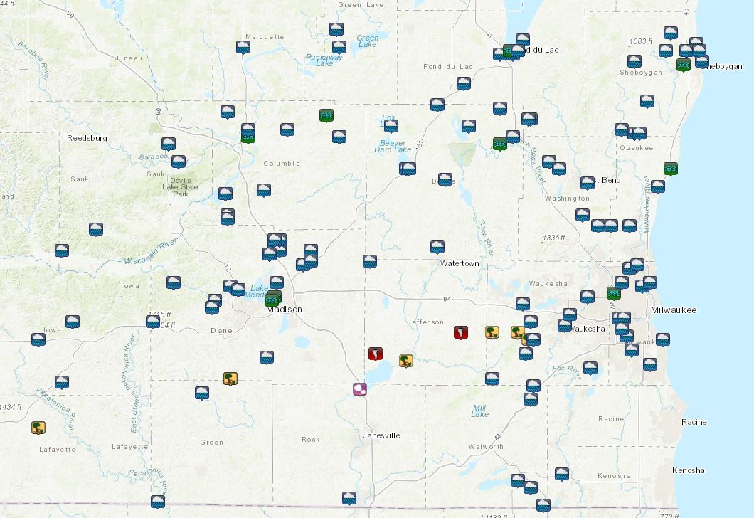
Click to Enlarge
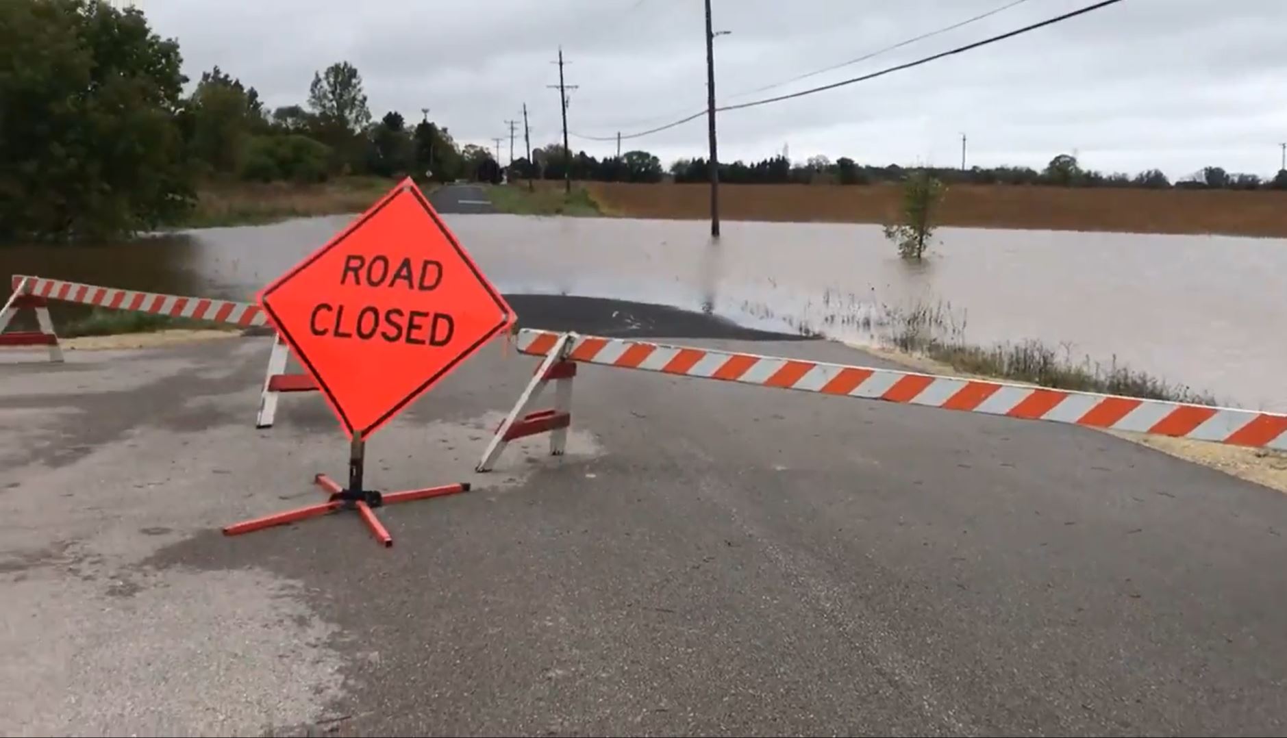
FLOODING
Rain began across southern Wisconsin during the early morning hours on Tuesday, October,1st becoming heavy at times. This led to morning rainfall totals in the 1-2 inch range with locally higher amounts, especially across Fond du Lac, Sheboygan, Columbia and Dodge counties. This initial round of storms cleared out and allowed for peaks of sun for some in the afternoon. As a result, the atmosphere destabilized throughout the afternoon and additional thunderstorms developed into the evening. This second punch of rain proved more potent and widespread than the morning round, providing an additional 2-3+ inches during the overnight hours into Wednesday, October 2nd.
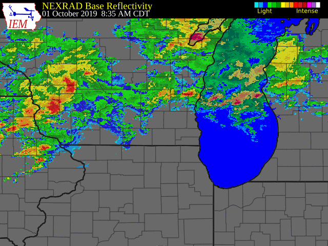
Radar reflectivity loop from early Tuesday morning through Wednesday morning.
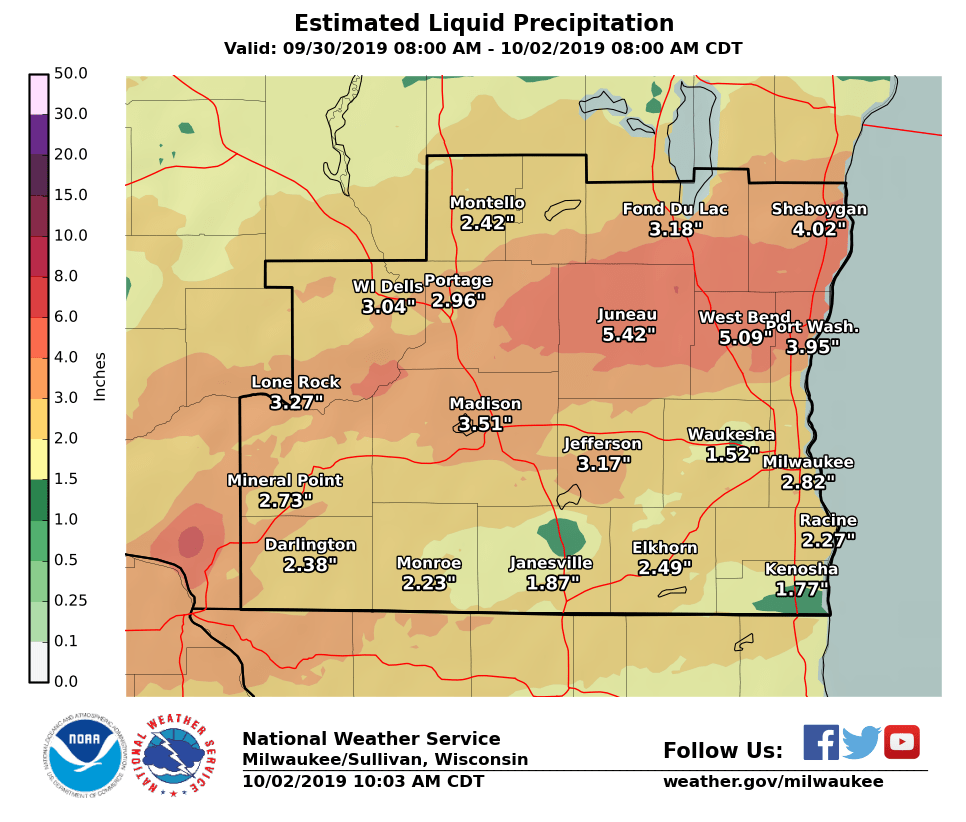
Storm total accumulations (inches) from 8 AM, Sept. 30 through 8 AM, Oct. 2
Hydrographs - See our hydrograph website for the latest information across all of southern Wisconsin.
Many rivers are already or forecast to be in minor or moderate flood stage.
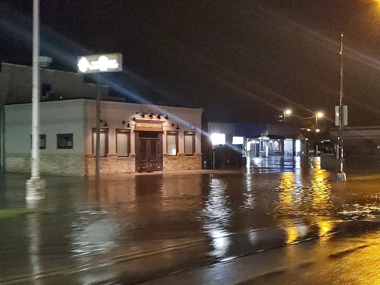
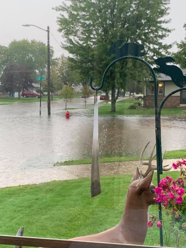
Photos
Flooding was observed in multiple areas across southern Wisconsin. Here are some of the images from the flooding rains.
 |
 |
 |
 |
|
East Mifflin & North Livingston in Madison Photo by: Sarah Jensen |
Foster Rd in Saukville Photo by: Lauren Linder |
Plymouth Photo by: Trained Spotter |
Sheboygan Photo by: Brittany Thimmesch |
Local Storm Reports - Rainfall
1152 AM CDT Wed Oct 2 2019

...PRECIPITATION REPORTS...

Location                     Amount    Time/Date       Lat/Lon

...Wisconsin...

...Columbia County...
Lodi                         4.53 in   1141 AM 10/02   43.38N/89.55W
Univ Farm                    3.91 in   0800 AM 10/02   43.30N/89.35W
Columbus 1.2 S               3.64 in   0700 AM 10/02   43.32N/89.03W
Portage 5.7 WSW              3.62 in   0600 AM 10/02   43.51N/89.57W
Lodi                         3.38 in   0700 AM 10/02   43.32N/89.53W
Portage 7.2 SW               3.35 in   0611 AM 10/02   43.48N/89.57W
Lodi                         3.31 in   1130 AM 10/02   43.32N/89.54W
Cambria                      3.13 in   1145 AM 10/02   43.54N/89.11W
Pardeeville                  2.96 in   1114 AM 10/02   43.56N/89.31W
Portage                      2.92 in   1131 AM 10/02   43.61N/89.54W
Poynette                     2.52 in   1144 AM 10/02   43.39N/89.40W
Lodi                         2.48 in   1144 AM 10/02   43.31N/89.54W

...Dane County...
DeForest                     3.94 in   1139 AM 10/02   43.25N/89.36W
Waunakee 4.9 W               3.63 in   0700 AM 10/02   43.20N/89.55W
De Forest 1.4 SSW            3.62 in   0700 AM 10/02   43.23N/89.35W
Madison 4.4 NE               3.61 in   0800 AM 10/02   43.12N/89.32W
Maple Bluff 1.7 N            3.53 in   0630 AM 10/02   43.13N/89.37W
Madison 5.5 N                3.52 in   0800 AM 10/02   43.16N/89.37W
Madison 5.0 SW               3.48 in   0700 AM 10/02   43.03N/89.48W
Sun Prairie 3.0 W            3.42 in   0700 AM 10/02   43.18N/89.29W
Madison 4.3 WSW              3.37 in   0600 AM 10/02   43.05N/89.46W
Madison 3.7 SW               3.36 in   0700 AM 10/02   43.05N/89.45W
Madison 6.4 W                3.36 in   0715 AM 10/02   43.08N/89.52W
Madison South-UW Arboretum   3.19 in   0940 AM 10/02   43.04N/89.43W
Sun Prairie                  3.19 in   1143 AM 10/02   43.22N/89.22W
Waunakee                     3.19 in   1136 AM 10/02   43.21N/89.38W
Madison 3.7 WSW              3.18 in   0700 AM 10/02   43.06N/89.46W
Madison 4.0 W                3.16 in   0700 AM 10/02   43.08N/89.47W
Cottage Grove 2.2 E          3.09 in   0700 AM 10/02   43.08N/89.16W
Black Earth                  3.07 in   1130 AM 10/02   43.13N/89.75W
Madison 6.1 W                3.04 in   0700 AM 10/02   43.07N/89.51W
McFarland 1.3 NE             3.01 in   0700 AM 10/02   43.03N/89.28W
Sun Prairie                  3.00 in   1145 AM 10/02   43.19N/89.22W
Verona 3.9 WSW               2.97 in   0700 AM 10/02   42.97N/89.61W
Madison 7.0 WSW              2.92 in   0800 AM 10/02   43.04N/89.51W
Stoughton                    2.90 in   0700 AM 10/02   42.92N/89.22W
Verona 5.5 WNW               2.90 in   0700 AM 10/02   43.03N/89.63W
Deerfield 0.6 N              2.88 in   0630 AM 10/02   43.06N/89.07W
Madison 4.0 SW               2.79 in   0700 AM 10/02   43.04N/89.44W
Middleton 0.8 SSW            2.71 in   0705 AM 10/02   43.09N/89.51W
2.0 SW Shorewood Hills       2.68 in   0700 AM 10/02   43.06N/89.48W
Madison-Dane County Airport  2.68 in   1053 AM 10/02   43.13N/89.35W
4 SE Cross Plains            2.65 in   1142 AM 10/02   43.06N/89.60W
Middleton                    2.38 in   1145 AM 10/02   43.11N/89.50W
2.0 S Mount Horeb            2.36 in   0700 AM 10/02   42.98N/89.74W
Oregon 0.4 SSW               2.19 in   0740 AM 10/02   42.92N/89.39W
Middleton                    1.81 in   1135 AM 10/02   43.12N/89.53W
Oregon                       1.71 in   1140 AM 10/02   42.92N/89.39W

...Dodge County...
Beaver Dam                   5.95 in   1015 AM 10/02   43.47N/88.84W
Horicon 2.1 ENE              5.89 in   0750 AM 10/02   43.45N/88.60W
Beaver Dam 1.4 SSW           5.72 in   0800 AM 10/02   43.45N/88.85W
Horicon-WWTP                 5.70 in   0700 AM 10/02   43.45N/88.63W
Theresa 0.5 SSW              5.61 in   0700 AM 10/02   43.51N/88.46W
Theresa 0.1 ESE              5.17 in   0700 AM 10/02   43.52N/88.45W
Horicon                      3.82 in   1128 AM 10/02   43.57N/88.61W
Columbus 4.8 ENE             3.66 in   0818 AM 10/02   43.36N/88.94W
Watertown                    2.11 in   1117 AM 10/02   43.23N/88.73W

...Fond du Lac County...
Campbellsport                5.89 in   1140 AM 10/02   43.59N/88.38W
1.8 E South Byron            3.17 in   1200 AM 10/02   43.63N/88.45W
St. Peter                    3.00 in   0655 AM 10/02   43.83N/88.35W
Fond Du Lac Airport          2.69 in   1053 AM 10/02   43.77N/88.48W
1 ESE Fond Du Lac            2.22 in   1145 AM 10/02   43.78N/88.42W

...Green County...
Winslow                      3.05 in   1145 AM 10/02   42.51N/89.81W
New Glarus                   3.02 in   1144 AM 10/02   42.82N/89.64W
1.2 W Monroe                 2.37 in   0700 AM 10/02   42.60N/89.67W
Monticello 2.2 SE            1.96 in   0700 AM 10/02   42.72N/89.56W

...Green Lake County...
0.6 SW Markesan              3.49 in   0700 AM 10/02   43.70N/89.00W
Green Lake 0.8 E             2.66 in   0700 AM 10/02   43.84N/88.94W
Princeton                    2.50 in   1135 AM 10/02   43.79N/89.11W
Markesan 4.1 NNW             2.32 in   0800 AM 10/02   43.76N/89.02W
Princeton                    2.30 in   1144 AM 10/02   43.84N/89.12W

...Iowa County...
Mineral Point 7.3 ENE        2.72 in   0700 AM 10/02   42.91N/90.06W
Mineral Point                2.65 in   1130 AM 10/02   42.85N/90.18W
Dodgeville                   2.57 in   1111 AM 10/02   43.02N/90.14W

...Jefferson County...
Fort Atkinson 0.3 SSE        3.74 in   0700 AM 10/02   42.92N/88.84W
Watertown 0.8 S              2.67 in   0700 AM 10/02   43.18N/88.72W
Waterloo                     2.58 in   1144 AM 10/02   43.19N/88.99W
0.5 SW Lake Mills            2.46 in   0600 AM 10/02   43.07N/88.91W
Johnson Creek 2.7 SSW        2.20 in   0530 AM 10/02   43.05N/88.80W

...Lafayette County...
Benton 0.3 WNW               2.75 in   0730 AM 10/02   42.57N/90.39W

...Marquette County...
Montello - I-39 @ STH 23 Eas 4.23 in   1118 AM 10/02   43.79N/89.48W
2.0 SE Montello              2.32 in   0700 AM 10/02   43.78N/89.30W

...Milwaukee County...
West Allis                   2.47 in   1143 AM 10/02   43.00N/88.02W
Milwaukee-Gen Mitchell Arpt  2.47 in   1052 AM 10/02   42.95N/87.90W
West Allis 0.7 SSE           2.45 in   0800 AM 10/02   43.00N/88.02W
Brown Deer                   2.23 in   1143 AM 10/02   43.17N/87.99W
Brown Deer                   2.22 in   1145 AM 10/02   43.18N/87.96W
4.0 SW Glendale              2.07 in   1100 AM 10/02   43.08N/87.96W
Milwaukee 3.6 NNW            1.99 in   0645 AM 10/02   43.11N/87.99W
1.0 N Glendale               1.93 in   1100 AM 10/02   43.14N/87.93W
2 NE West Allis              1.92 in   1144 AM 10/02   43.03N/88.01W
3.1 E Butler                 1.86 in   1100 AM 10/02   43.13N/88.02W
Wauwatosa 1.9 E              1.79 in   0700 AM 10/02   43.06N/88.00W
1 NNW Whitefish Bay          1.72 in   1145 AM 10/02   43.13N/87.91W
1 N West Allis               1.69 in   1145 AM 10/02   43.03N/88.03W
Glendale                     1.64 in   1141 AM 10/02   43.12N/87.94W

...Ozaukee County...
Port Washington              5.27 in   1144 AM 10/02   43.40N/87.88W
West Bend 7.3 E              4.87 in   0700 AM 10/02   43.43N/88.04W
Port Washington 4.2 NE       4.36 in   0700 AM 10/02   43.44N/87.83W
Cedarburg                    4.16 in   1141 AM 10/02   43.29N/88.06W
Port Washington-CoCoRaHS     3.95 in   0700 AM 10/02   43.39N/87.88W
Mequon 3.3 ESE               2.86 in   0641 AM 10/02   43.22N/87.93W
Cedarburg                    2.33 in   1144 AM 10/02   43.29N/87.99W

...Racine County...
Racine 2.3 WSW               1.86 in   0657 AM 10/02   42.71N/87.85W
Racine 2.4 S                 1.60 in   0700 AM 10/02   42.69N/87.81W
Racine 3.0 WNW               1.52 in   0700 AM 10/02   42.74N/87.86W

...Rock County...
0.5 NE South Beloit          1.84 in   0535 AM 10/02   42.50N/89.03W
Janesville 6.0 SW            1.71 in   0541 AM 10/02   42.62N/89.09W

...Sauk County...
0.9 SW Sauk City             4.07 in   0621 AM 10/02   43.26N/89.74W
Reedsburg 1.3 N              3.93 in   0505 AM 10/02   43.55N/90.00W
Lone Rock-Airport            3.89 in   1056 AM 10/02   43.22N/90.18W
Baraboo                      2.97 in   1130 AM 10/02   43.47N/89.73W
Rock Springs 2.8 WSW         2.81 in   0700 AM 10/02   43.46N/89.97W
Baraboo                      2.48 in   0548 AM 10/02   43.49N/89.72W
La Valle 3.5 W               2.38 in   0700 AM 10/02   43.59N/90.20W
Dells Baraboo                2.29 in   1135 AM 10/02   43.52N/89.77W

...Sheboygan County...
2.3 NW Oostburg              4.62 in   0700 AM 10/02   43.66N/87.81W
Sheboygan 3.2 NW             4.42 in   0630 AM 10/02   43.78N/87.77W
Sheboygan 0.7 SSW            4.31 in   0730 AM 10/02   43.74N/87.73W
Random Lake-CoCoRaHS         4.14 in   0700 AM 10/02   43.55N/87.95W
Random Lake                  3.34 in   1145 AM 10/02   43.55N/87.97W
Sheboygan                    3.29 in   1142 AM 10/02   43.78N/87.77W
Howards Grove                3.18 in   1132 AM 10/02   43.83N/87.83W
Random Lake                  3.03 in   1140 AM 10/02   43.55N/87.95W
1 NNW Sheboygan              2.76 in   1145 AM 10/02   43.78N/87.72W
Sheboygan-Airport            2.73 in   1117 AM 10/02   43.78N/87.85W
Plymouth                     2.57 in   1131 AM 10/02   43.75N/87.97W
Oostburg                     1.64 in   1144 AM 10/02   43.62N/87.79W

...Walworth County...
Lyons 0.4 SE                 2.68 in   0730 AM 10/02   42.65N/88.35W
Darien 1.6 NNE               2.55 in   0700 AM 10/02   42.62N/88.70W
Elkhorn 0.4 ESE              2.49 in   0530 AM 10/02   42.67N/88.53W
Lake Geneva 0.6 ENE          2.44 in   0733 AM 10/02   42.59N/88.42W
Genoa City 2.7 NW            1.94 in   0650 AM 10/02   42.53N/88.36W
1.4 E Pell Lake              1.88 in   0645 AM 10/02   42.53N/88.33W

...Washington County...
West Bend 1.3 NNW            5.65 in   0616 AM 10/02   43.44N/88.20W
Kewaskum 1.8 WNW             4.87 in   0700 AM 10/02   43.53N/88.27W
Jackson 0.5 SSE              4.58 in   0700 AM 10/02   43.31N/88.16W
Hartford 1.7 ESE             4.44 in   0700 AM 10/02   43.31N/88.36W
0.7 SW Hartford              4.26 in   0630 AM 10/02   43.32N/88.40W
Hartford 3.8 E               4.25 in   0700 AM 10/02   43.32N/88.31W
Hartford 2.9 ENE             4.19 in   0700 AM 10/02   43.34N/88.34W
Allenton 1.4 WSW             4.15 in   0549 AM 10/02   43.42N/88.37W
West Bend 3.4 WSW            4.09 in   0700 AM 10/02   43.41N/88.25W
Richfield 2.8 WNW            3.96 in   0800 AM 10/02   43.27N/88.25W
West Bend                    3.68 in   1131 AM 10/02   43.45N/88.26W
West Bend                    3.62 in   1141 AM 10/02   43.41N/88.15W
Jackson-CoCoRaHS             3.43 in   0600 AM 10/02   43.32N/88.17W
Jackson                      3.36 in   1130 AM 10/02   43.32N/88.17W
West Bend                    3.24 in   1142 AM 10/02   43.47N/88.30W
Jackson                      3.08 in   1143 AM 10/02   43.29N/88.11W
West Bend 1.4 W              3.02 in   0800 AM 10/02   43.42N/88.21W
Germantown 0.9 SW            2.48 in   0700 AM 10/02   43.23N/88.13W
1.4 S Germantown             2.47 in   0700 AM 10/02   43.22N/88.12W
Germantown 1.0 NE            2.45 in   0600 AM 10/02   43.23N/88.10W
Germantown 0.6 S             2.35 in   0700 AM 10/02   43.23N/88.12W
1.9 SE Hubertus              2.25 in   0600 AM 10/02   43.21N/88.21W

...Waukesha County...
Muskego 1.0 W                2.72 in   0620 AM 10/02   42.89N/88.14W
Mukwonago 0.5 N              2.40 in   0800 AM 10/02   42.87N/88.33W
Menomonee Falls 3.2 NNW      2.36 in   0700 AM 10/02   43.19N/88.16W
Hartland 5.0 NNE             2.31 in   0445 AM 10/02   43.16N/88.30W
Delafield                    2.24 in   1143 AM 10/02   43.02N/88.37W
Oconomowoc 0.9 W             2.23 in   0737 AM 10/02   43.10N/88.51W
Mukwonago 5.3 W              2.22 in   0700 AM 10/02   42.85N/88.44W
Dousman 4.6 SSW              2.22 in   0700 AM 10/02   42.95N/88.50W
Delafield                    2.13 in   1131 AM 10/02   43.07N/88.40W
North Prairie                2.07 in   1140 AM 10/02   42.93N/88.39W
Waukesha                     1.72 in   1142 AM 10/02   43.01N/88.24W
Waukesha 1.6 NW              1.68 in   0900 AM 10/02   43.03N/88.26W
Pewaukee                     1.67 in   1140 AM 10/02   43.04N/88.22W
Genesee Depot                1.66 in   1145 AM 10/02   42.97N/88.36W
Brookfield                   1.58 in   1143 AM 10/02   43.09N/88.15W
Waukesha 1.6 NW              1.58 in   0700 AM 10/02   43.03N/88.26W
Elm Grove                    1.54 in   1144 AM 10/02   43.05N/88.08W
2.9 W Brookfield             1.52 in   0740 AM 10/02   43.05N/88.18W
Waukesha 2.9 WNW             1.52 in   0700 AM 10/02   43.03N/88.29W
New Berlin                   1.51 in   1226 AM 10/02   42.97N/88.07W

Observations are collected from a variety of sources with varying
equipment and exposures. We thank all volunteer weather observers
for their dedication. Not all data listed are considered official.
Written by: Cameron Miller, Rebecca Rogers and J. J. Wood
__________________________________________________________________________________________________________________________
 |
Media use of NWS Web News Stories is encouraged! Please acknowledge the NWS as the source of any news information accessed from this site. |
|