
Monsoonal moisture will produce showers and thunderstorms with heavy rain over parts of the Southwest, Great Basin, and Central Rockies through Monday. Flash flooding is possible, especially in and around burn scars and in areas of steep terrain. Heat will persist across the Central U.S. early this week, spreading into the Ohio Valley and Mid-Atlantic later this week. Read More >
Lake Charles, LA
Weather Forecast Office
|
|
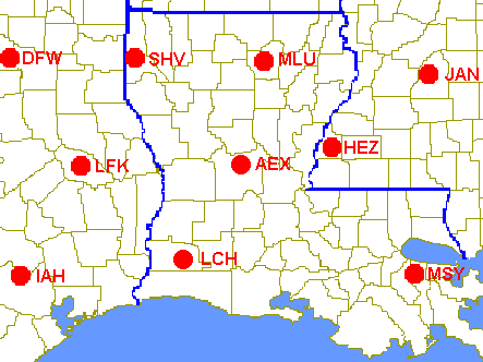
| GOES Temperature and Moisture Soundings
Click on a station to get its latest GOES-derived sounding. |
||||||||||
 |
||||||||||
|
||||||||||
NOTE: GOES satellite soundings are available only when sky conditions are clear or partly cloudy. In cloudy conditions, or when GOES sounder data is missing, a message 'Sounding Unavailable' will be displayed. |
||||||||||
For other locations around North and Central America, click here. |
Forecasts
Local Products
Model Data
Forecaster's Discussion
Fire Weather
Graphical Forecasts
Wet Bulb Globe Temps
Aviation Weather
Activity Planner
Mardi Gras Decision Support
Marine Forecasts
Other Links
National Hurricane Ctr
Storm Prediction Ctr
Weather Prediction Ctr
Other Links
Office History
LCH StoryMap
Hazards
Severe Weather
Tropical Weather
National Outlooks
Local Storm Reports
Tropical Cyclone Reports
Current
Tide Data
Satellite Data
Observations
Hydrology
Jefferson Co. DD6 Network
River/Lake Forecasts
Calcasieu Par. Network
Radar
Shreveport (SHV)
New Orleans (LIX)
Fort Polk (POE)
Houston/Galveston (HGX)
Lake Charles (LCH)
Probabilistic Pages
Probabilistic Rainfall
Probabilistic DSS
Probabilistic Snowfall

US Dept of Commerce
National Oceanic and Atmospheric Administration
National Weather Service
Lake Charles, LA
500 Airport Boulevard
Lake Charles, LA 70607
(337) 477-5285 M-F 8a to 4p only
Comments? Questions? Please Contact Us.


 Follow us on X
 Follow us on Facebook
 Follow us on YouTube
 LCH RSS Feed