Tropical Depression Two is expected to gradually strengthen and could bring tropical storm conditions to the Florida Panhandle beginning late Monday. Areas of flash flooding will be possible through Thursday along the eastern and central Gulf Coast. Severe thunderstorms will develop and move along a cold front crossing the Upper Midwest Monday, and through the Ohio Valley/Mid-Atlantic on Tuesday. Read More >
Meteorological Comparison of Hurricanes Audrey and Rita
Compiled by:
Donovan Landreneau, Forecaster
Sam Shamburger, Forecaster
Comparing Hurricane Audrey to Hurricane Rita
June 27, 1957 to September 23-24, 2005
|
Minimum Sea Level Pressure |
||||
| Location | Hurricane Audrey | Hurricane Rita | ||
| inches of mercury | millibars | inches of mercury | millibars | |
| Alexandria, LA | 29.00" | 982.1 mb | 29.28" | 991.5 mb |
| Baton Rouge, LA | 29.54" | 1000.3 mb | 29.46" | 997.6 mb |
| Cameron, LA | *28.32" | *959 mb | *<28.06" | *<950 mb |
| Galveston, TX | 29.13" | 986.5 mb | **29.37" | **994.6 mb |
| Lafayette, LA | 29.34" | 993.6 mb | 29.30" | 992.2 mb |
| Lake Charles, LA | 28.69" | 971.4 mb | 28.59" | 968.2 mb |
| Lufkin, TX | 29.34" | 993.6 mb | **29.27" | **991.2 mb |
| Monroe, LA | 29.07" | 984.4 mb | 29.47" | 998.0 mb |
| New Orleans, LA | 29.65" | 1004.2 mb | 29.60" | 1002.4 mb |
| Port Arthur, TX (SE TX Regional) |
28.67" | 970.9 mb | 28.12" | 952.3 mb |
| Shreveport, LA | 29.28" | 991.3 mb | 29.05" | 983.8 mb |
|
* estimated/unofficial |
||||
|
Maximum Sustained Winds & Wind Gusts |
|||||
| Location | Data Source | Hurricane Audrey | Hurricane Rita | ||
| Maximum Sustained Wind (1-minute avg.) |
Peak Wind Gust | Maximum Sustained Wind (2-minute avg.) |
Peak Wind Gust | ||
| Alexandria, LA | NWS | 48 mph | 64 mph | 50 mph | 62 mph |
| Baton Rouge, LA | NWS | 40 mph | 69 mph | 41 mph | 53 mph |
| Cameron, LA | NOAA | unknown | unknown | **77 mph | **112 mph |
| Galveston, TX | NWS | 58 mph | 76 mph | **45 mph | **62 mph |
| Lafayette, LA | NWS | 58 mph | 86 mph | 51 mph | 59 mph |
| Lake Charles, LA | NWS | 75 mph | 97 mph | 76 mph | 96 mph |
| Lufkin, TX | NWS | 20 mph | 32 mph | **33 mph | **50 mph |
| Monroe, LA | NWS | 35 mph | 63 mph | 31 mph | 43 mph |
| New Orleans, LA | NWS | 35 mph | 53 mph | 35 mph | 48 mph |
| Orange, TX | FCMP | unknown | *100 mph | 75 mph | 98 mph |
| Port Arthur, TX (SE TX Regional) |
NWS | 72 mph | 85 mph | 81 mph | 105 mph |
| Shreveport, LA | NWS | 30 mph | 51 mph | 40 mph | 53 mph |
|
* estimated/unofficial |
|||||
|
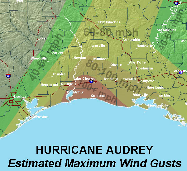
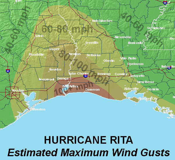
Estimated Maximum Wind Gust maps |
|
| Hurricane Audrey | Hurricane Rita |
|
|
|
|
Storm Surge |
||
| Location | Hurricane Audrey | Hurricane Rita |
| MSL | NGVD88 | |
| Calcasieu Pass, LA | 12.1 ft | *6.7 ft |
| Cameron, LA | 10.6 ft | 16.2 ft |
| Cypremort Point, LA | 10.2 ft | 12.1 ft |
| Grand Chenier, LA | 13.9 ft | 14.5 ft |
| Hackberry, LA | 6.7 ft | 8.0 ft |
| Intracoastal City, LA | 8.1 ft | 11.0 ft |
| Johnsons Bayou, LA | 10.4 ft | 12.4 ft |
| Lake Charles, LA | 7.0 ft | 8.4 ft |
| Morgan City, LA | 8.5 ft | 6.1 ft |
| Oak Grove, LA | 12.4 ft | 13.4 ft |
| Pecan Island, LA | 10.9 ft | 10.4 ft |
| Sabine Pass, TX | 9.4 ft | 9.8 ft |
|
* last data recorded before equipment failure |
||
|
Rainfall |
|||
| Location | Data Source | Hurricane Audrey | Hurricane Rita |
| Alexandria Power Plant, LA | NWS COOP | 3.70" | *7.60" |
| Baton Rouge, LA | NWS | 1.51" | 9.30" |
| Galveston, TX | NWS | 1.85" | * |
| Lafayette, LA | NWS | 3.69" | 6.24" |
| Lake Charles, LA | NWS | 7.57" | 7.68" |
| Lufkin, TX | NWS | 0.27" | 5.51" |
| Monroe, LA | NWS | 2.85" | 3.50" |
| New Orleans, LA | NWS | 0.15" | 2.07" |
| Port Arthur, TX | NWS | 6.90" | 8.89" |
| Shreveport, LA | NWS | 0.45" | 5.54" |
| Monroe, LA | NWS | 2.85" | 3.50" |
|
* official data unavailable due to equipment failure |
|||