National Weather Service United States Department of Commerce

Major Winter Storm to Impact the Mid-Atlantic and Northeast; Inclement Weather in the Pacific Northwest

A major winter storm is expected to bring heavy snow, strong winds, and coastal flooding across the Mid-Atlantic and Northeast that may cause impossible travel conditions and power outages. Blizzard conditions are possible along coastal areas from the DelMarVa Peninsula through southeastern New England. Wet weather and strong winds return to the Pacific Northwest and north-central California. Read More >

Hurricane Gustav Storm Tide Data

LOCATION

PEAK STORM TIDE
(MLLW)

PEAK STORM SURGE
(MLLW)

DATE/TIME (CDT)

Amerada Pass LA 4.77 feet 3.39 feet 9/01 at 2:30 pm
Freshwater Canal Locks LA 4.01 feet 2.69 feet 9/03 at 2:06 am
Calcasieu Pass LA 3.90 feet 1.17 feet 9/03 at 4:06 am
Cypremort Point LA 3.20 feet 2.63 feet 9/02 at 6:06 pm
Sabine Pass North TX 2.82 feet 1.90 feet 9/03 at 3:12 pm
Lake Charles LA 2.82 feet 1.91 feet 9/03 at 3:06 pm
Port Arthur TX 2.25 feet 1.32 feet 9/03 at 6:00 am
Tesoro Terminal LA 2.17 feet 1.70 feet 9/01 at 8:12 pm
Rainbow Bridge TX 1.34 feet 2.09 feet 9/03 at 3:12 am


Hurricane Gustav River Flood Data

LOCATION

RIVER CREST

RIVER CREST
(NAVD 88)

FLOOD STAGE

DATE/TIME (CDT)

Calcasieu River at Glenmora LA 14.42 feet 125.22 feet 12.00 feet 9/04 at 8:00 pm
Calcasieu River at Oakdale LA 13.10 feet 96.17 feet 12.00 feet 9/04 at 8:30 am
Calcasieu River at Oberlin LA 16.65 feet 56.14 feet 13.00 feet 9/06 at 2:00 am
Calcasieu River at Old Town Bay LA 4.75 feet 2.65 feet 4.00 feet 9/03 at 12:00 pm
Calcasieu River at Salt Water Barrier LA 4.69 feet 4.08 feet 4.00 feet 9/03 at 3:00 pm
Vermilion River at Lafayette LA 11.24 feet 8.50 feet 10.00 feet 9/04 at 2:00 am
Vermilion River at Carencro LA 19.01 feet N/A 16.00 feet 9/04 at 12:00 pm
Vermilion River at Broussard LA 8.58 feet N/A 7.00 feet 9/04 at 4:00 am
Atchafalaya River at Morgan City LA 4.40 feet N/A 4.00 feet 9/02 at 7:00 am
 

Salt Water Burn

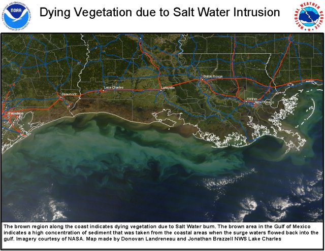
High resolution satellite image showing salt water burn to the marshes and prairie pasturelands as a result of both Gustav and Ike. Click here for a .pdf version of this image.