
Tropical Depression Two is expected to gradually strengthen and could bring tropical storm conditions to the Florida Panhandle beginning late Monday. Areas of flash flooding will be possible through Thursday along the eastern and central Gulf Coast. Severe thunderstorms will develop and move along a cold front crossing the Upper Midwest Monday, and through the Ohio Valley/Mid-Atlantic on Tuesday. Read More >
Lake Charles, LA
Weather Forecast Office
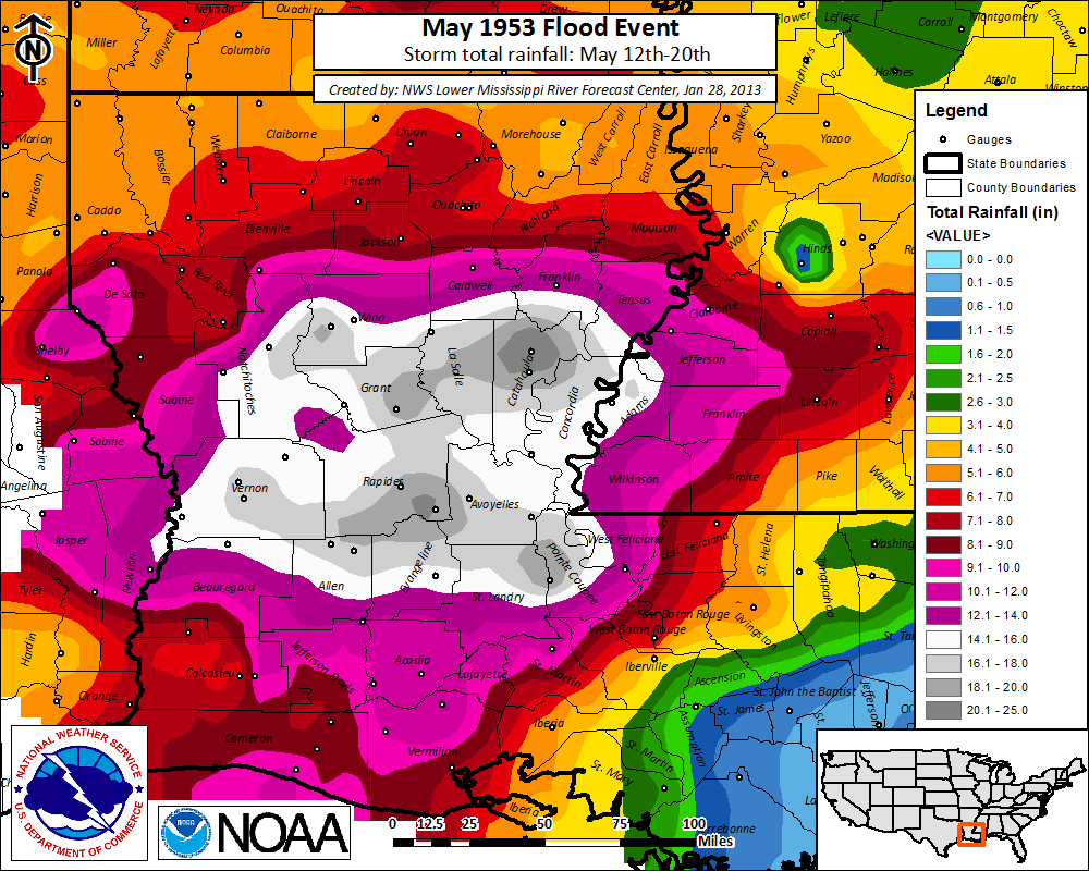
A series of rain events produced widespread heavy rainfall across the region with the highest amounts of 14 to 25 inches noted across Central Louisiana. This occurred on top of what was already a wet year. The result was the worst flooding on record at several of the gauging stations in Southwest and Central Louisiana.
Historical crests on area rivers
courtesy NWS AHPS
| Flood State (ft) | ||||||
| Body of water | Location | Crest (ft) | Date | Minor | Major | All-time |
| Calcasieu R. | Glenmora | 21.55 | 5/19/53 | 12 | 18 | record |
| Calcasieu R. | Oakdale | 22.62 | 5/19/53 | 12 | 22 | record |
| Calcasieu R. | Oberlin | 26.53 | 5/19/53 | 13 | 19 | record |
| Calcasieu R. | Kinder | 32.00 | 5/19/53 | 16 | 23 | record |
| Calcasieu R. | Old Town Bay | 16.10 | 5/21/53 | 4 | 8 | record |
| Whisky Chitto C. | Mittie | 32.80 | 5/18/53 | 15 | 23 | record |
| B. Nezpique | Basile | 34.39 | 5/20/53 | 22 | 28 | record |
| B. Des Cannes | Eunice | 22.36 | 5/20/53 | 16 | 21 | record |
| B. Cocodrie | Clearwater | 26.72 | 5/18/53 | 19 | 23 | record |
| Mermentau R. | Mermentau | 13.36 | 5/23/53 | 4 | 8 | 2nd |
| Sabine R. | Bon Weir | 38.70 | 5/19/53 | 30 | 36 | 4th |
| Sabine R. | Deweyville | 29.98 | 5/22/53 | 24 | 28 | 3rd |
| Neches R. | Town Bluff | 82.85 | 5/21/53 | 68 | 82 | 3rd |
| Neches R. | Evadale | 22.53 | 5/24/53 | 17 | 24 | 4th |
Forecasts
Marine Forecasts
Local Products
Model Data
Forecaster's Discussion
Fire Weather
Graphical Forecasts
Wet Bulb Globe Temps
Aviation Weather
Activity Planner
Mardi Gras Decision Support
Other Links
National Hurricane Ctr
Storm Prediction Ctr
Weather Prediction Ctr
Other Links
Office History
LCH StoryMap
Hazards
Severe Weather
Tropical Weather
National Outlooks
Local Storm Reports
Tropical Cyclone Reports
Current
Observations
Tide Data
Satellite Data
Hydrology
Jefferson Co. DD6 Network
River/Lake Forecasts
Calcasieu Par. Network
Radar
Shreveport (SHV)
New Orleans (LIX)
Fort Polk (POE)
Houston/Galveston (HGX)
Lake Charles (LCH)
Probabilistic Pages
Probabilistic Rainfall
Probabilistic DSS
Probabilistic Snowfall
US Dept of Commerce
National Oceanic and Atmospheric Administration
National Weather Service
Lake Charles, LA
500 Airport Boulevard
Lake Charles, LA 70607
(337) 477-5285 M-F 8a to 4p only
Comments? Questions? Please Contact Us.

