Tropical Depression Two is expected to gradually strengthen and could bring tropical storm conditions to the Florida Panhandle beginning late Monday. Areas of flash flooding will be possible through Thursday along the eastern and central Gulf Coast. Severe thunderstorms will develop and move along a cold front crossing the Upper Midwest Monday, and through the Ohio Valley/Mid-Atlantic on Tuesday. Read More >
January 2 Severe Weather and Tornadoes
| Event Overview |
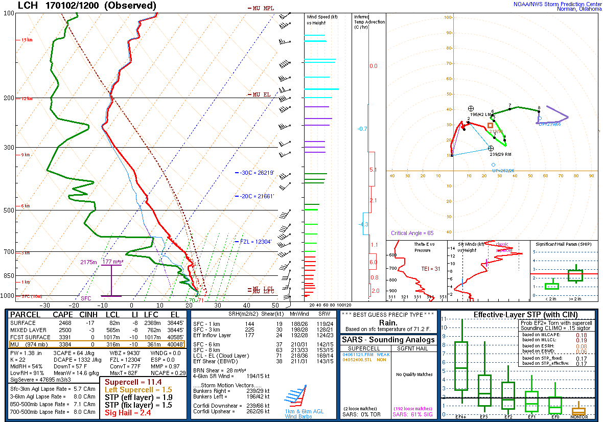
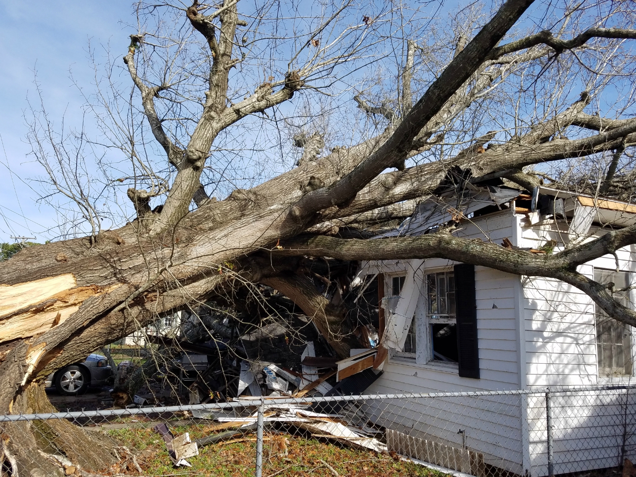
| A complex of thunderstorms developed ahead of a cold front in west Texas and moved eastward during the early morning hours of January 2nd. Southerly flow ahead of the storm system ushered in moist air from the Gulf of America with dewpoints reaching the upper 60s and low 70s across southeast Texas and southwest Louisiana by daybreak. The warm, moist air combined with colder air aloft to produce an unstable atmosphere across the region. Additionally, strong wind fields over the area were supportive of organized thunderstorms. The complex of thunderstorms strengthened as it entered this favorable environment and went on to produce damaging winds along with tornadoes across much of the Gulf Coast. |
Tornado Table
| Time | Location | Strength | Killed | Injuries | Path Length | Max Path Width |
| Jan 2 9:03 AM | Brookeland, TX | EF-1 | 0 | 0 | 2.6 Miles | 100 Yards |
| Jan 2 9:44 AM | Trout Creek, TX | EF-1 | 0 | 0 | 0.3 Miles | 20 Yards |
| Jan 2 10:06 AM | Fields, LA | EF-1 | 0 | 0 | 0.3 Miles | 20 Yards |
| Jan 2 10:17 AM | Oretta, LA | EF-1 | 0 | 0 | 1.2 Miles | 50 Yards |
| Jan 2 10:30 AM | Longville, LA | EF-1 | 0 | 0 | 4.6 Miles | 100 Yards |
| Jan 2 10:30 AM | Ragley, LA | EF-1 | 0 | 0 | 2.8 Miles | 100 Yards |
| Jan 2 11:06 AM | Boyce, LA | EF-1 | 0 | 0 | 0.5 Miles | 50 Yards |
| Jan 2 11:30 AM | Mamou, LA | EF-0 | 0 | 0 | 0.5 Miles | 25 Yards |
| Jan 2 11:31 AM | Meeker, LA | EF-1 | 0 | 0 | 1.4 Miles | 100 Yards |
| Jan 2 11:44 AM | Bunkie, LA | EF-1 | 0 | 0 | 1.6 Miles | 200 Yards |
| Jan 2 11:47 AM | Hessmer, LA | EF-1 | 0 | 0 | 2.4 Miles | 200 Yards |
| Jan 2 11:51 AM | Marksville, LA | EF-1 | 0 | 0 | 1.0 Miles | 200 Yards |
EF Scale: The Enhanced Fujita Scale classifies tornadoes into the following categories:
EF0...Weak........65 to 85 MPH
EF1...Weak.......86 to 110 MPH
EF2...Strong....111 to 135 MPH
EF3...Strong....136 to 165 MPH
EF4...Violent....166 to 200 MPH
EF5...Violent.............>200MPH
2 January Multi-Radar Loop
2 January 12Z sounding