|

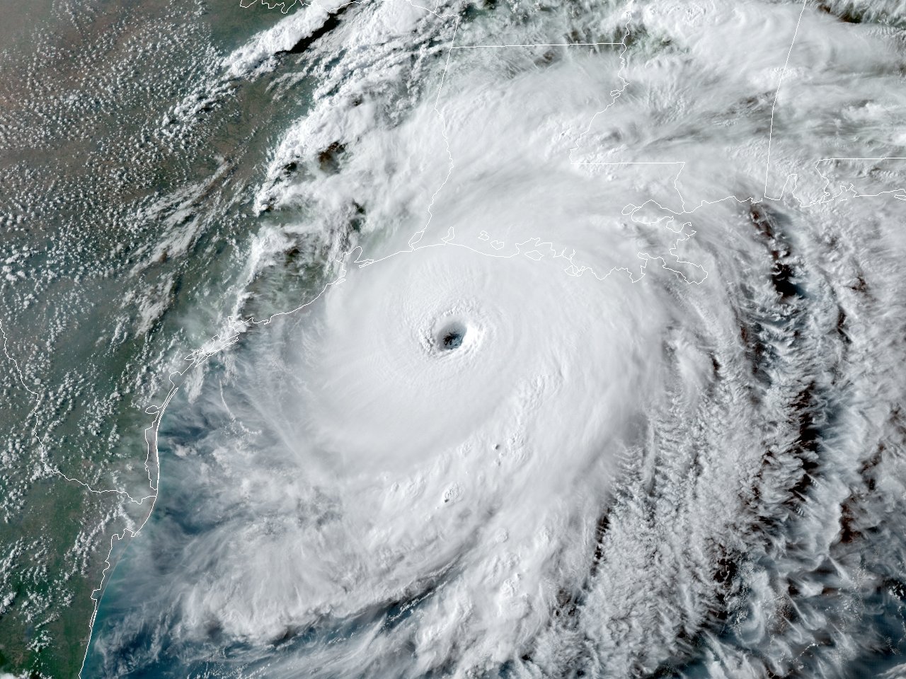
Above: GOES 16 GeoColor Satellite Image of Hurricane Laura at 6:01 PM CDT on August 26, 2020.
Laura began as a large tropical wave that emerged off the west coast of Africa on August 16th. The wave traversed the tropical Atlantic for the next several days with little additional organization. On August 19th, the system became better organized, closed off a low-level circulation, and subsequently the National Hurricane Center began issuing advisories on Tropical Depression Thirteen late that evening.
On the morning of August 21st, Tropical Depression Thirteen strengthened into Tropical Storm Laura, which was the earliest twelfth named Atlantic storm, beating the previous record of Hurricane Luis of 1995 by eight days. As Laura moved westward, little additional strengthening took place as the center moved over the northern Lesser Antilles later that evening, and south of Puerto Rico on August 22nd. Early on August 23rd, Tropical Storm Laura made landfall across Hispaniola, traversed the entire island, and made landfall across Eastern Cuba later that evening. Tropical Storm Laura continued west northwestward, traveling just south of the island with a second landfall across Western Cuba late on August 24th.
On August 25th, Laura entered the Gulf and became a Category 1 hurricane at 10 AM CDT. Laura began to explosively intensify on August 26th, reaching category 2 by 1 AM CDT, category 3 by 7 AM CDT, and category 4 by 1 PM CDT. Laura reached a peak intensity of 150 mph (130 knots) and a minimum central pressure of 937 millibars (27.67 inches) by 7 PM CDT.
With little change in strength, Laura made landfall at Cameron, Louisiana around 1 AM CDT August 27th, with sustained winds of 150 mph (130 knots) and a minimum central pressure of 939 millibars (27.73 inches). Laura was the strongest hurricane to strike Southwest Louisiana since records began in 1851. The eye and eyewall of Laura passed over the entire Lake Charles metropolitan area including Lake Charles, Sulphur, Westlake, Moss Bluff and De Quincy while Laura was still a very powerful category 4 hurricane. Laura maintained major hurricane status throughout its passage across Cameron, Calcasieu and southern Beauregard Parishes, and category 2 status across northern Beauregard and Vernon parishes. Laura finally weakened below hurricane strength by Noon as it was crossing I-20 in North Louisiana. Click here for additional track data of Hurricane Laura.
With this being the strongest hurricane to affect Southwest Louisiana, wind damage to buildings and trees and storm surge damage was major to catastrophic across Cameron and Calcasieu parishes, with considerable damage occurring where the core of the hurricane passed across Beauregard and Vernon parishes. Wind damage to trees and structures as well as damage from the storm surge occurred in Vermilion and Iberia Parishes. Numerous trees, power lines and power poles were blown down in Jefferson, Orange, Hardin, Tyler, Jasper, and Newton Counties in Texas, with some homes and businesses damaged from the trees or the winds in those counties. Homes and other structures were damaged from fallen trees or the winds in Jefferson Davis, Acadia, Lafayette, Saint Martin, Beauregard, Allen, Evangeline, Saint Landry, Vernon, Rapides, and Avoyelles Parishes, Louisiana.
WIND & PRESSURE:
Across Cameron Parish, the highest winds of 153 mph (133 knots) was measured at Holly Beach, Louisiana at 12:33 AM CDT on August 27th with a pressure of 945.0 millibars (27.91 inches of mercury). Further east at Cameron, the National Ocean Service tide gage measured a peak wind of 127 mph (110 knots) at 12:24 AM CDT and a minimum sea level pressure of 940.0 mb (27.76 inches) at 12:54 AM CDT August 27th. Other observations sites failed within the high winds and storm surge.
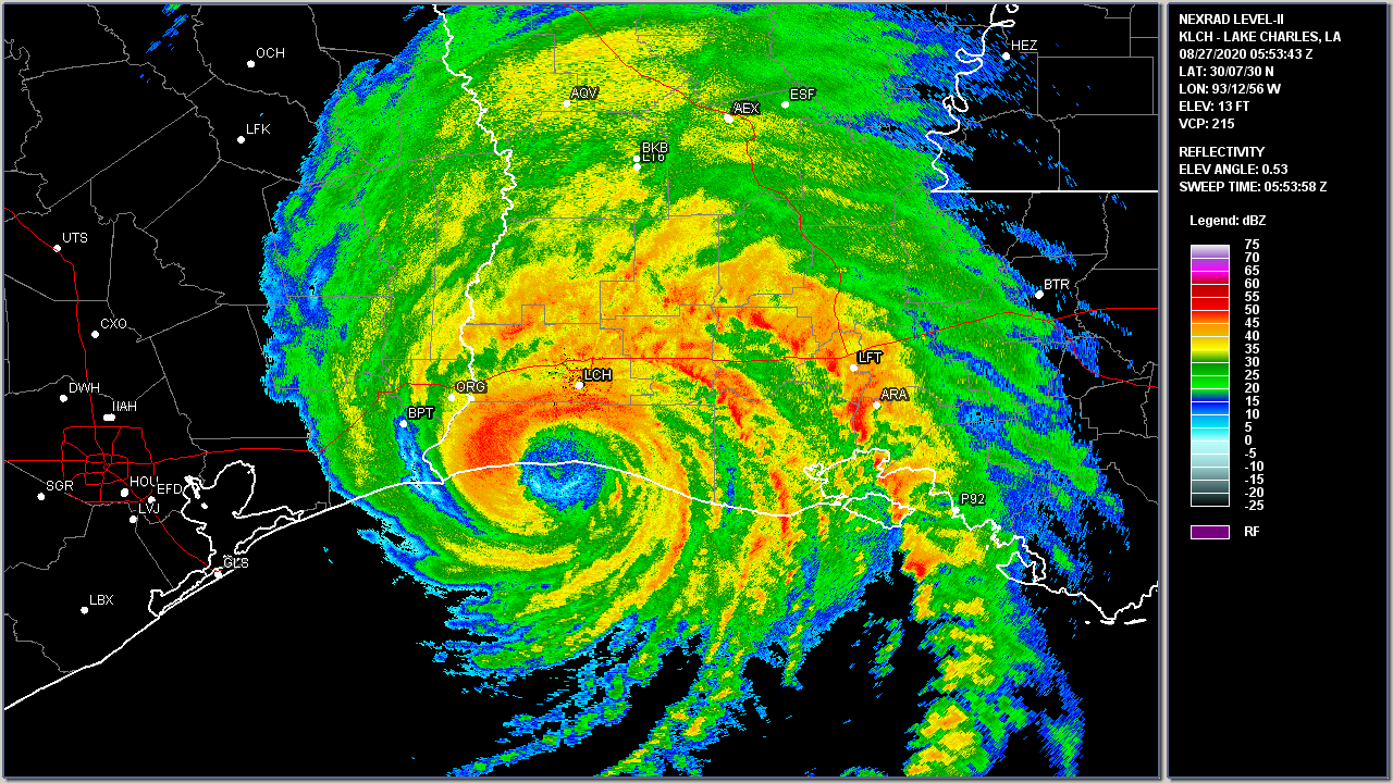
The National Weather Service Lake Charles, Louisiana (located at the Lake Charles Regional Airport) recorded a station record highest peak wind gust of 133 mph (116 knots) at 1:42 AM CDT just before the KLCH ASOS (Automated Surface Observing System) equipment was destroyed. However, the ASOS barometer sensor that was safely within the LCH NWS building (which remained intact) recorded a station record minimum sea level pressure of 956 millibars (28.23 inches) at 2:20 AM CDT when the eye of Hurricane Laura passed nearly overhead. The Lake Charles, LA WSR-88D recorded the final radar image at 12:53 AM CDT. Upon first inspection of the National Weather Service Lake Charles station discovered the WSR-88D radome failure within the high winds of the eyewall.
Across the remainder of Calcasieu Parish, downtown Lake Charles, Louisiana at the Calcasieu Parish Police Jury building, measured a maximum sustained wind of 101 mph (88 knots) with a peak gust of 137 mph (119 knots) at 1:35 AM CDT August 27th just before the instrument failed. A University of Florida portable wind tower (FCMP T1) that was placed about one mile southwest of Chennault International Airport reported a maximum sustained wind of 104 mph (90 knots) with a peak gust of 132 mph (115 knots) at 2:00 AM CDT August 27th (anemometer height of 33 feet). At the KCWF AWOS METAR observation site at Chennault International Airport, the instruments began failing between the 12:35 AM and 12:55 AM CDT observations on August 27th, only recording wind observations at 1:15 AM CDT (wind gust of 83 mph/72 knots) and 2:35 AM CDT (wind gust of 93 mph (81 knots), missing the peak wind gust between these times. Another University of Florida portable wind tower (FCMP T3) was placed between Sulphur and Carlyss reported a maximum sustained wind of 79 mph (69 knots) with a peak gust of 110 mph (96 knots) at 2:02 AM CDT August 27th (anemometer height of 33 feet). The AWOS METAR site at Carlyss (KUXL) AWOS METAR observation site recorded its final observation at 12:15 AM CDT August 27th, about 1-2 hours before the maximum winds arrived. Further north, the De Quincy (K5R8) AWOS METAR observation site recorded its final observation at 3:15 AM CDT August 27th before the maximum winds arrived as well. Most of the METAR ASOS/AWOS failures were due to power failures and destruction of the equipment.
Texas Tech University deployed about 40-50 portable weather stations extending across the I-10 corridor of Southern Louisiana and Southeast Texas, with the greatest concentration across Calcasieu & Jeff Davis parishes in Southwest Louisiana, and Orange & Jefferson Counties in Southeast Texas. The height of the wind sensors averaged between 7-8 feet above the ground (as compared to the official observations at 33 to 39 feet above the ground with the METAR, NOS, and WeatherFlow observations), and had slightly lower wind gusts. Nevertheless, peak wind gusts of 115 to to 125 mph around 7-8 feet were recorded at several locations across Calcasieu Parish.
Damaging winds associated with Laura extended well inland over Central and Northern Louisiana near and east of Laura's eye. Surface observations indicated that hurricane-force-winds in gusts occurred as far north as Natchitoches, LA. Some notable observations, such as the De Ridder AWOS METAR recorded a peak gust of 82 mph (71 knots) at 4:40 AM August 27th right before the eye moved overhead, recording a minimum sea level pressure of 965.9 mb (28.52 inches) central pressure at 5:15 AM within the still well defined eye. The Alexandria ASOS METAR recorded a peak gust of 91 mph (79 knots) at 8:45 AM August 27th.
STORM SURGE:
Storm surge was catastrophic across Cameron Parish, especially around Cameron, Creole, and Grand Chenier where the highest inundation was observed. Several structures had over 13 feet inundation above ground level with one structure showing 17.1 feet above ground level in Creole, LA. Inundation estimates show near or just over 18 feet above ground level, but unable to verify due to the structures being destroyed. Storm surge inundated just about all of Cameron Parish with the exception of a portion of Highway 384 that runs along the ridge in Northcentral Cameron Parish and a small area just west of Hackberry.
Further east across Vermilion, Iberia, and Western St. Mary Parishes, storm surge inundation was around 5 to 10 feet above the ground mainly along and south of the Intracoastal Canal. Some of the notable measurements across Vermilion Parish were 7.9 feet above ground level near Freshwater City, 5-6 feet above ground level along Highway 82 near Pecan Island, and 3 feet near Delcambre. Across Iberia and Western St. Mary Parish, estimated inundation of 6-8 feet extended as far north between Delcambre and the Port of Iberia. A measurement of 8.1 feet above ground level was found at Cypremort Point.
Elsewhere, the storm surge penetrated as far north as Highway 14 across Southeastern Calcasieu Parish near Hayes and Bell City, and approached the Lake Charles Regional Airport near Lincoln Road. Storm surge also penetrated northward along the Calcasieu River basin, flooding the lower elevations near the river and its tributaries across Lake Charles. The storm surge also penetrated northward across southern Jeff Davis Parish around Lake Arthur and across Highway 90 near Mermentau. Click here to access storm surge maps and data.
RAINFALL:
Because of the quick movement of Laura, the heaviest rainfall of 5-11 inches was confined to the eastern and western eyewall, as well as the principal rain-band across Jeff Davis, Lafayette, and St. Landry parishes. The maximum rainfall measured rainfall of 11.74 inches occurred 2 miles ENE of Starks, LA. There might have been higher amounts, but due to the extreme damage across Cameron and Calcasieu, Jeff Davis, and Beauregard parishes, many of the rain gauges were damaged or even lost. The rainfall map created incorporates MRMS rainfall estimates from surrounding radars, and the Lake Charles and Fort Polk up to the time of communications failure.
See the NWS Lake Charles Post Tropical Cyclone Report and the National Hurricane Center Tropical Cyclone Report for a complete list of all the data recorded, as well as storm effects by parish and county associated with Hurricane Laura. Click here to view the Graphical Post Storm Report (.kmz) file of Hurricane Laura's Track, Maximum Wind, Lowest Sea Level Pressure, & Maximum Tide Inundation that can be viewed in Google Earth.

Above: Lake Charles, LA WSR-88D radar of Hurricane Laura landfall and final image recorded at 12:53 AM CDT on August 27, 2020.

Above: Hurricane Laura at Cameron, LA Landfall. Left: 2km Infrared satellite image at 0556 UTC (12:56 AM CDT). Right: Lake Charles, LA WSR-88D radar image at 0553 UTC (12:53 AM CDT) on August 27, 2020.
Listed below are post-storm reports and meteorological data gathered. All data is considered preliminary, and is subject to change at any time. Additional information will continue to be added to this page in the future.
Webpage design by: Donovan Landreneau
Content by: NWS Lake Charles & Brownsville staff, other sources as noted above.
|
