|

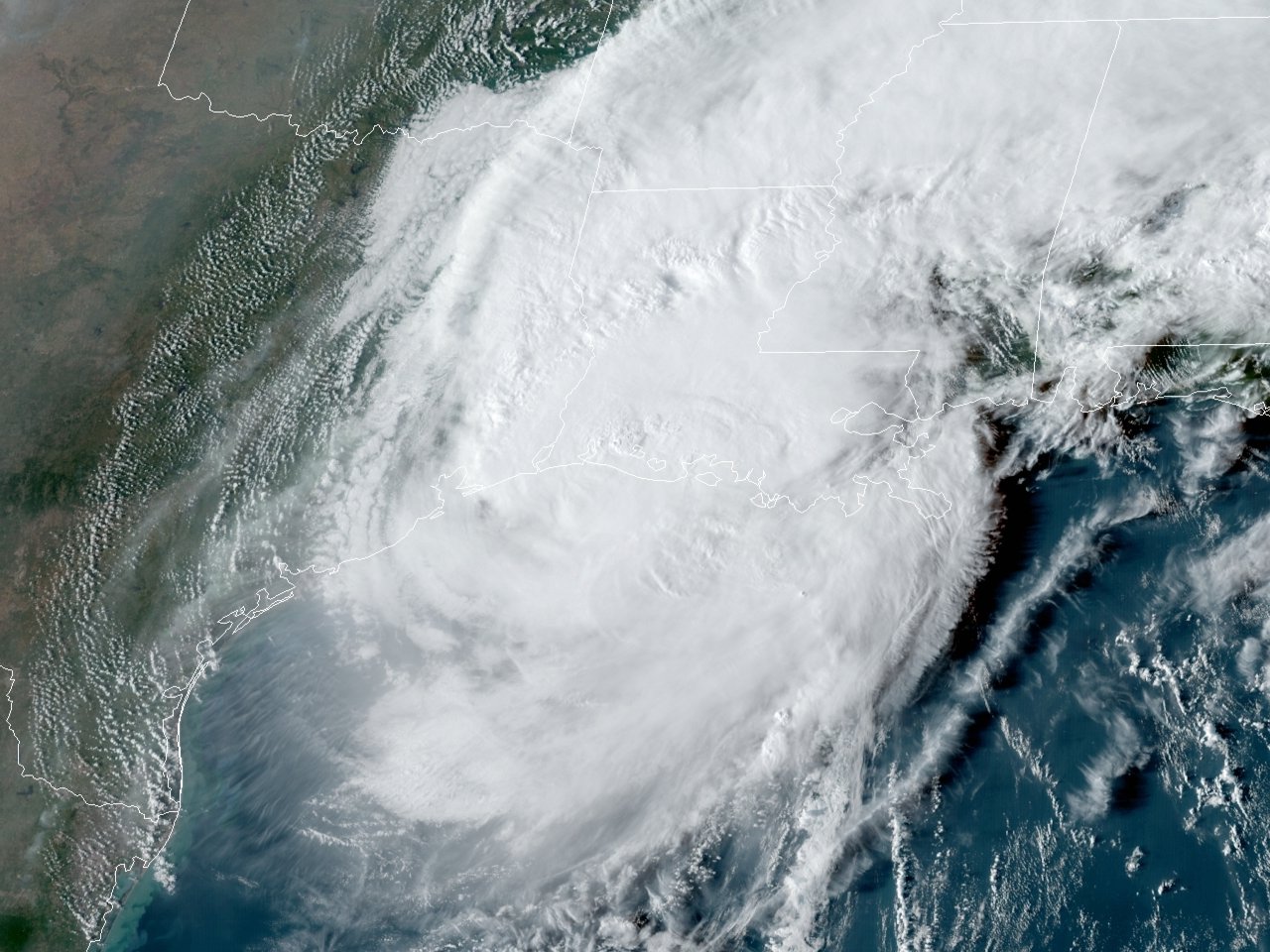
Above: GOES 16 GeoColor Satellite Image of Hurricane Delta at 5:01 PM CDT on October 9, 2020.
Delta began as a tropical wave across Eastern Caribbean Sea on October 1st. By the afternoon of October 4th, the system became better organized, closed off a low-level circulation, and subsequently the National Hurricane Center began issuing advisories on Tropical Depression Twenty-six.
Just after daybreak on October 5th, Tropical Depression Twenty-six strengthened into Tropical Storm Delta, and quickly strengthened into a hurricane by that evening. Delta, with its small circulation, continued its extremely rapid intensification, reaching category 4 intensity with sustained winds of 140 mph (120 knots) by the afternoon of October 6th across the Northwestern Caribbean Sea. Continuing to move northwestward, Delta weakened to a category 2 hurricane by the time it made landfall across the Northeast Yucatán Peninsula early on October 7th. Delta further weakened to a category 1 hurricane over land and emerged across the Southern Gulf.
Delta continued to move northwest and began to intensify over the open Gulf along with its circulation expanding. Delta turned to the north and regained category 3 intensity by the afternoon of October 8th. Delta reached a secondary peak intensity of 120 mph (105 knots) and minimum central pressure of 953 millibars (28.14 inches) the evening of October 8th through early on October 9th over the Western Gulf. As Delta continued north heading for Southwest Louisiana, drier air and increasing southwesterly wind shear caused Delta to begin a slow weakening trend. Delta was downgraded to a Category 2 hurricane by 1 PM CDT as it turned north-northeastward towards Cameron Parish Louisiana.
Delta made landfall near Creole, Louisiana with winds of 100 mph (85 knots) and a pressure of 970 millibars (28.64 inches) at 6 PM CDT October 9th, which was 12 miles east of where Hurricane Laura made landfall six weeks earlier. Just before and during landfall, increasing wind shear and baroclinic forcing had degraded the circulation on satellite and radar, weakening to a category 1 hurricane by 7 PM that evening. However, Delta’s wind field expanded somewhat, extending the period of hurricane force winds from Southeast Texas to South Central Louisiana that evening. Delta weakened to a tropical storm by 1 AM CDT on October 10th while the center of circulation was just southeast of Alexandria, Louisiana. Click here for additional track data for Hurricane Delta.
With Southwest Louisiana still in recovery after Major Hurricane Laura, the winds and rainfall from Delta further delayed the recovery efforts, and in many cases, caused significant additional damage to homes and businesses. Many buildings that had roof or structural damage caused by Hurricane Laura still had temporary tarping, which was ripped off by the hurricane force winds of Delta.
Other significant problems arose with the extent of tree and structural debris placed on the side of the roadways, and in many cases, the drainage ditches. The hurricane force winds blew some of this debris from the piles. However, the biggest problem came with Delta’s large circulation and rain shield dropping 12 to 18 inches of rainfall across portions of Southeast and Central Louisiana. This, coupled with the debris in the drainage ditches, caused significant flooding, especially in the flood pronged areas.
Delta was the ninth named storm of the year to make landfall in the continental United States, tied with 1916. However, the record was eventually broken with the tenth named storm to make landfall in the continental United States with Hurricane Zeta, and the eleventh named storm on November 8th with Tropical Storm Eta. Delta was also the third named storm to make landfall in Louisiana in a single season, and later tying the record of four (previously set in 2002) on October 28th when Hurricane Zeta made landfall near Cocodrie in Southeastern Louisiana.
WIND & PRESSURE:
Delta was a large but weakening category two hurricane at landfall that generated hurricane force wind gusts from Southeast Texas to South Central Louisiana. The highest wind gusts occurred across Cameron, Calcasieu, and Jeff Davis Parishes.
Eastern Jefferson County, the Southeast Texas Regional Airport recorded a peak gust of 90 mph (78 knots) at 6:17 PM CDT with a minimum sea level pressure of 989.8 millibars (29.23 inches) at 6:43 PM CDT October 9th.
Cameron Parish, the NOS Texas Point gauge at Sabine Pass recorded a wind gust of 100 mph (87 knots) at 6:00 PM CDT and a minimum sea level pressure of 983.7 millibars (29.05 inches) at 6:06 PM CDT October 9th. The NOS Calcasieu Pass gauge at Cameron recorded a peak wind of 90 mph (78 knots) at 6:54 PM CDT and a minimum sea level pressure of 973.5 millibars (28.75 inches) 5:24 PM CDT October 9th.
Calcasieu Parish, the National Weather Service Lake Charles, Louisiana recorded a peak gust of 96 mph (83 knots) at 6:11 PM CDT with a minimum sea level pressure of 981.7 millibars (28.99 inches) at 6:52 PM CDT October 9th.
Jeff Davis Parish, the Jennings airport recorded a peak gust of 81 mph (70 knots) at 6:35 PM CDT with a minimum sea level pressure of 976.3 millibars (28.83 inches) at 7:55 PM CDT October 9th.
Iberia Parish, the New Iberia airport recorded a peak gust of 86 mph (75 knots) at 6:53 PM CDT with a minimum sea level pressure of 988.8 millibars (29.20 inches) at 7:45 PM CDT October 9th.
Lafayette Parish, the Lafayette airport recorded a peak gust of 75 mph (65 knots) at 8:04 PM CDT with a minimum sea level pressure of 988.9 millibars (29.20 inches) at 8:42 PM CDT October 9th.
St. Landry Parish, the Opelousas airport recorded a peak gust of 75 mph (65 knots) at 8:55 PM CDT with a minimum sea level pressure of 984.7 millibars (29.08 inches) at 10:15 PM CDT October 9th.
STORM SURGE:
Storm surge inundated most of Cameron parish, Vermilion parish south of Highway 14, and Iberia & St. Mary parishes south of U.S. 90, areas that were severely inundated by Hurricane Laura just 6 weeks earlier.
The highest values of 8-10 feet above ground level were observed across the eastern half of Cameron Parish including Cameron, Creole, and Grand Cheniere. The peak storm surge was considerably less than with Laura. However, the large size of Delta caused inundation across most of the parish once again, with the exception of a portion of Highway 384 that runs along the ridge in Northcentral Cameron Parish and just west of Hackberry.
Further east across Vermilion, Iberia, and Western St. Mary Parishes, storm surge inundation was quite similar to Hurricane Laura 6 weeks earlier, averaging around 5 to 10 feet above the ground mainly along and south of the Intracoastal Canal.
RAINFALL:
Rainfall of 12-18 inches occurred across Central and Southwest Louisiana where the core of Delta passed over. The highest measured rainfall of 17.57 occurred 3 SSE of Lebleu Settlement, LA in Calcasieu Parish. However, MRMS estimates up to 20+ inches fell across Allen and Rapides Parishes in locations where no observations sites were located. This, coupled with the debris in the drainage ditches, caused significant flooding, especially in the flood pronged areas.
Elsewhere, rainfall of 5-10 inches occurred across Southeast Texas and South-Central Louisiana caused localized flooding.

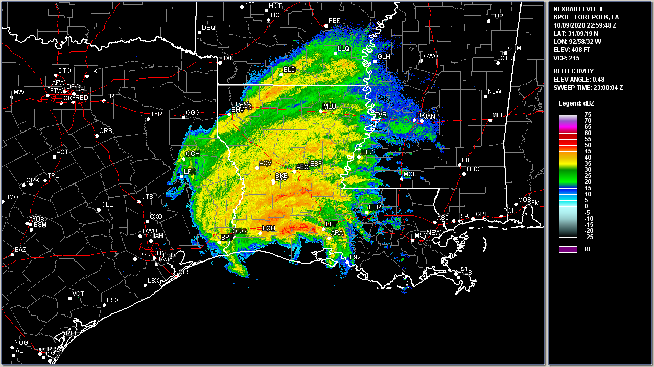
Above: Fort Polk, LA WSR-88D radar image of Hurricane Delta landfall at 5:59 PM CDT on October 9, 2020.
Listed below are post-storm reports and meteorological data gathered. All data is considered preliminary, and is subject to change at any time. Additional information will continue to be added to this page in the future.
DOW = CSWR's Doppler on Wheels (DOW) network
Webpage design by: Donovan Landreneau
Content by: NWS Lake Charles staff, other sources as noted above.
|