Wichita, Kansas
Weather Forecast Office
|
Our Mission Statement: Serve the Public By:
|
NWS data and products form a national information database and infrastructure which can be used by other government agencies, the private sector, the public, and the global community.
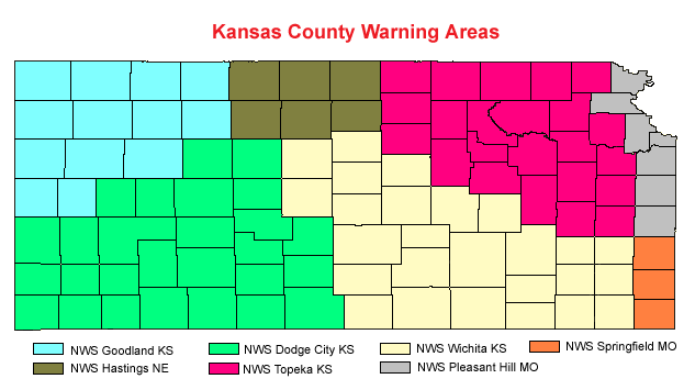
This image map below portrays the state of Kansas and the County Warning and Forecast Areas assigned to the respective National Weather Service Forecast Offices, by color code. By clicking on a particular NWS County Warning Area, this will take you to the appropriate NWS Forecast Office Homepage. The NWS Wichita County Warning Area and Forecast Area of responsibility is colored in light yellow.

Some of the new advanced technologies being utilized at the modernized NWS Forecast Offices, nationwide include: AWIPS II, ASOS, WSR-88D Doppler Radar, GOES Satellite, National Center Advanced Computer Systems, and NOAA Weather Radio.
Hazards
Briefing pages
Local weather story
Submit a storm report
Storm Prediction Center
Enhanced Hazardous Weather Outlook
Current Conditions
Local Radar
National Radar
Satellite
Hourly weather(text)
Precip Analysis
Snowfall analysis
This day in weather history
7 Day Lightning Archive
Forecasts
Forecast Discussion
Weather Story
Fire Weather
Activity Planner
Aviation Weather
Soaring Forecast
Hurricane Center
Graphical Forecasts
Regional Weather Summary
Probabilistic Snow
Probabilistic QPF
Wet Bulb Globe temp
Climate
Local Climate Page
Daily/Monthly data(F6)
Daily Records
Climate Normals
Local drought page
Latest Climate Report(ICT)
Latest Climate Report(SLN)
Latest Climate Report(CNU)
CoCoRaHS
7 Day Lightning Archive
US Dept of Commerce
National Oceanic and Atmospheric Administration
National Weather Service
Wichita, Kansas
2142 S. Tyler Road
Wichita, KS 67209-3016
316-942-3102
Comments? Questions? Please Contact Us.

