Overview
|
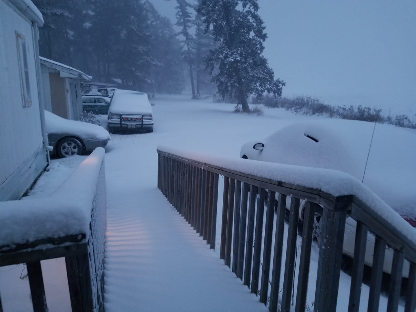
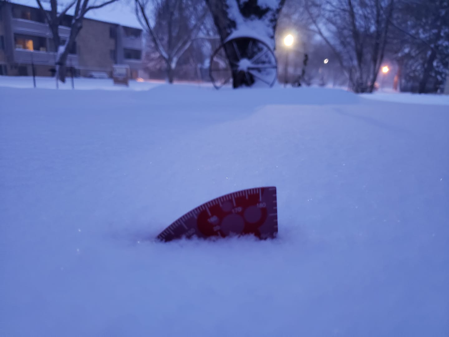
A strong winter storm moving into the central US on the weekend after the Thanksgiving holiday brought widespread snow to the Northern Plains. After a round of freezing drizzle that brought slippery roads to central and eastern North Dakota and the Red River Valley, snow began during the early morning hours of November 30th. By the afternoon of November 30th, heavy snow had spread northward across much of the region, causing widespread travel impacts across the Dakotas and Minnesota. |
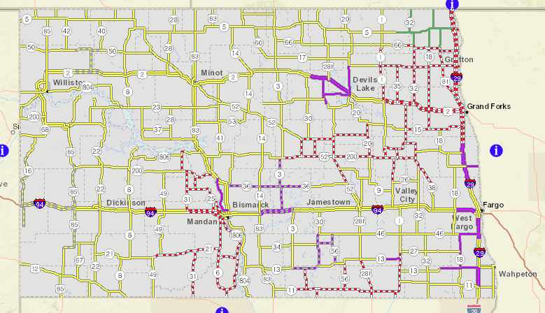 Travel impacts across North Dakota during the morning of December 1, 2019 |
Snow
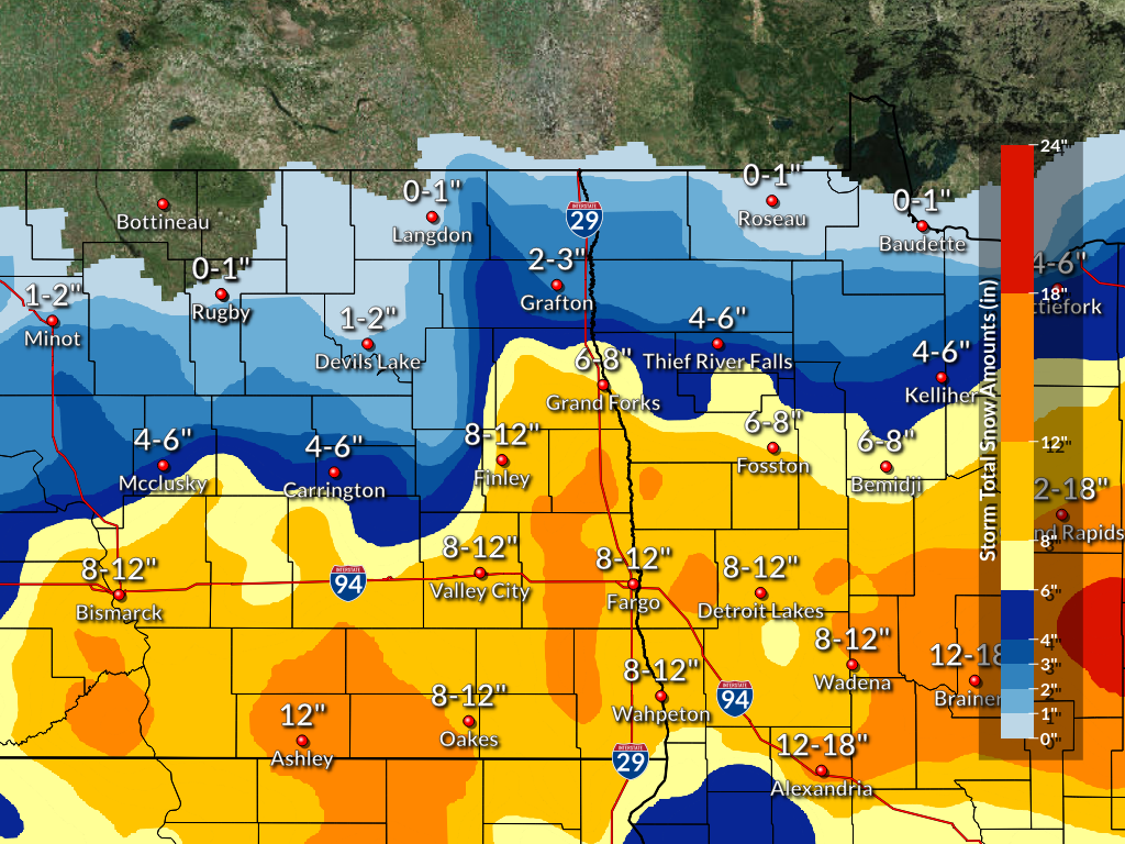
Here is a map of snowfall totals that occurred across the region from November 30, 2019 to December 1, 2019.
 |
Photos & Video
Photos of impacts across the region
 |
 |
 |
 |
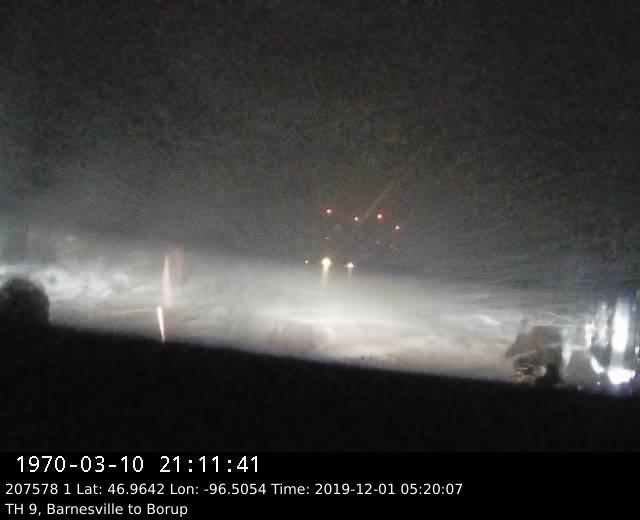
| Plow Camera on the morning of Dec 30 at around 5:30 AM northeast of Fargo (MN DOT) |
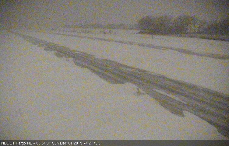
I-29 South of Fargo (ND DOT) |
A snowy evening in northwest MN (Sue Chberreq) |
Over 7" reported in the Fargo area. (Britta Lea Tollefson) |
Radar
Snowfall Reports
...SNOWFALL REPORTS...

Location                     Amount    Time/Date       Provider

...Minnesota...

...Becker County...
Lake Park MN 6.0 S           11.5 in   0700 AM 12/01   COCORAHS
Detroit Lakes                10.5 in   1100 AM 12/01   Public
3 NNW Cormorant              10.0 in   1030 AM 12/01   Public
4 S Audubon                  9.5 in    0730 AM 12/01   Public
Detroit Lakes MN 5.7 N       8.5 in    0730 AM 12/01   COCORAHS
Osage                        6.0 in    0840 PM 11/30   Public

...Beltrami County...
Bemidji MN 4.8 NNE           7.2 in    0700 AM 12/01   COCORAHS
Turtle River MN 3.6 E        5.3 in    0745 AM 12/01   COCORAHS
Tenstrike                    4.0 in    1200 AM 12/01   Public

...Clay County...
1 SE Moorhead                10.0 in   1123 AM 12/01   Broadcast Media
2 SE Moorhead                8.9 in    0800 AM 12/01   Public
Sabin MN                     6.5 in    0645 AM 12/01   UCOOP

...Clearwater County...
Bagley                       6.0 in    1216 PM 12/01   Dept of Highways
Lake Itasca                  6.0 in    0700 PM 11/30   Public

...Grant County...
Kensington MN 4.1 W          5.0 in    0700 AM 12/01   COCORAHS
Hoffman MN 4.0 WSW           3.9 in    0700 AM 12/01   COCORAHS

...Hubbard County...
Park Rapids                  12.0 in   1216 PM 12/01   Dept of Highways
Park Rapids                  9.0 in    0810 AM 12/01   Public
6 ENE Becida                 8.0 in    1050 PM 11/30   Public
3 WSW Rosby                  7.5 in    0855 PM 11/30   Public

...Kittson County...
Hallock                      2.0 in    1156 AM 12/01   Dept of Highways
Lancaster MN                 1.1 in    0700 AM 12/01   UCOOP

...Mahnomen County...
3 N Waubun                   5.0 in    0600 PM 11/30   Public

...Norman County...
Hendrum                      12.0 in   0800 AM 12/01   Public
Ada                          8.0 in    0925 PM 11/30   Public

...Otter Tail County...
Fergus Falls MN 5.6 NNE      10.0 in   0700 AM 12/01   COCORAHS
Fergus Falls MN 0.5 E        9.3 in    0700 AM 12/01   COCORAHS
Deer Creek MN 2.0 WSW        9.1 in    0700 AM 12/01   COCORAHS
Pelican Rapids MN 6.3 NNW    8.0 in    0756 AM 12/01   COCORAHS
Pelican Rapids               7.5 in    0800 AM 12/01   Public
Richville MN 5.8 SSW         6.0 in    0700 AM 12/01   COCORAHS
Parkers Prairie              6.0 in    0915 PM 11/30   Law Enforcement
Pelican Rapids               6.0 in    0915 PM 11/30   Law Enforcement
Fergus Falls                 5.9 in    0925 PM 11/30   Public
Bluffton                     4.0 in    0150 PM 11/30   Public
2 NNW Big Mcdonald Lake      3.0 in    0400 PM 11/30   Public
3 ENE Richville              3.0 in    1227 PM 11/30   Public
1 ENE Rothsay                1.3 in    0730 AM 11/30   CO-OP Observer
Ottertail MN                 0.5 in    0708 AM 11/30   COOP

...Pennington County...
Thief River Falls            6.0 in    1156 AM 12/01   Dept of Highways
Thief River Falls            6.0 in    0940 PM 11/30   Law Enforcement
Goodridge MN 7.4 SW          4.2 in    0700 AM 12/01   COCORAHS

...Polk County...
Crookston                    7.0 in    0940 PM 11/30   Law Enforcement
Fertile                      6.0 in    0940 PM 11/30   Law Enforcement
3 NNW Davidson               5.5 in    0815 PM 11/30   Public
Crookston MN 0.6 ENE         4.0 in    0630 AM 12/01   COCORAHS
Mentor MN 2.5 SSW            3.5 in    0800 AM 12/01   COCORAHS
Erksine MN 7.6 SSW           0.1 in    0800 AM 11/30   COCORAHS

...Roseau County...
Greenbush MN                 1.0 in    0700 AM 12/01   UCOOP

...Wadena County...
Sebeka MN                    13.8 in   0700 AM 12/01   UCOOP
Verndale                     12.0 in   0800 AM 12/01   Public
2 N Menahga                  11.0 in   1114 AM 12/01   Public
3 NNW Sebeka                 5.0 in    0430 PM 11/30   Public
4 N Sebeka                   3.5 in    0104 PM 11/30   Public

...Wilkin County...
Breckenridge                 4.0 in    0945 PM 11/30   Law Enforcement
Breckenridge                 4.0 in    0942 PM 11/30   Broadcast Media
Wolverton MN 1.1 ENE         0.3 in    0700 AM 11/30   COCORAHS

...North Dakota...

...Barnes County...
Valley City ND 2.0 NW        10.0 in   0700 AM 12/01   COCORAHS
Valley City                  8.0 in    0900 PM 11/30   Law Enforcement
Valley City                  6.0 in    0326 PM 11/30   Law Enforcement

...Cass County...
Durbin ND 5.4 WNW            12.5 in   0700 AM 12/01   COCORAHS
Arthur                       12.0 in   1000 AM 12/01   Public
2 ENE Arthur                 11.0 in   0100 AM 12/01   Public
Fargo ND 3.6 NNE             10.0 in   0700 AM 12/01   COCORAHS
West Fargo                   9.8 in    0345 PM 11/30   Public
Fargo                        9.3 in    0629 AM 12/01   CO-OP Observer
1 SSW Oxbow                  9.3 in    0623 AM 12/01   CO-OP Observer
Arthur                       9.0 in    0800 PM 11/30   Public
Fargo                        7.8 in    1130 PM 11/30   Public
Leonard                      5.8 in    0115 PM 11/30   Public
Harwood                      5.3 in    0400 PM 11/30   Public
Fargo                        5.0 in    0500 PM 11/30   Public
Arthur                       5.0 in    0200 PM 11/30   Public
West Fargo                   5.0 in    1200 PM 11/30   Public
1 NE Prairie Rose            2.3 in    1200 PM 11/30   CO-OP Observer
2 SSW Casselton              1.0 in    0800 AM 11/30   CO-OP Observer
West Fargo ND 3.8 SSE        0.5 in    0700 AM 11/30   COCORAHS

...Grand Forks County...
5 WNW Grand Forks            9.5 in    1200 AM 12/01   COOP
8 SSE Logan Center           9.0 in    0730 AM 12/01   Public
1 WNW Grand Forks            8.1 in    0600 AM 12/01   Official NWS Obs
Grand Forks                  8.0 in    1214 AM 12/01   Public
Grand Forks ND 3.4 SSE       7.5 in    0700 AM 12/01   COCORAHS
Northwood                    7.5 in    1000 PM 11/30   Public
1 S Grand Forks              7.3 in    0820 PM 11/30   Public
1 WNW Grand Forks            7.0 in    0930 PM 11/30   Official NWS Obs
1 WNW Grand Forks            6.5 in    0745 PM 11/30   Official NWS Obs
1 WNW Grand Forks            4.5 in    0600 PM 11/30   Official NWS Obs
2 SSE Grand Forks            4.0 in    0430 PM 11/30   CO-OP Observer
Grand Forks Afb              3.0 in    0200 PM 11/30   Public

...Griggs County...
2 E Hannaford                5.0 in    0545 PM 11/30   Public

...Pembina County...
Cavalier ND 7.9 WNW          1.3 in    1108 AM 12/01   COCORAHS
Cavalier ND 7 NW             0.2 in    0700 AM 12/01   COOP

...Ransom County...
Lisbon                       10.0 in   0910 PM 11/30   Public
Lisbon ND 0.5 ENE            6.0 in    0800 AM 12/01   COCORAHS

...Richland County...
Mcleod ND 3 E                13.7 in   0800 AM 12/01   COOP
Walcott                      10.0 in   1030 PM 11/30   Public
Lidgerwood ND                9.0 in    0700 AM 12/01   COOP
Hankinson                    8.0 in    1050 PM 11/30   Public
Wahpeton                     4.0 in    0910 PM 11/30   Law Enforcement
Mcleod ND 3 E                2.2 in    0840 AM 11/30   COOP
1 WSW Lidgerwood             1.0 in    0700 AM 11/30   CO-OP Observer
Abercrombie ND 0.2 NW        0.3 in    0600 AM 11/30   COCORAHS

...Steele County...
Sharon ND 7.9 ENE            9.0 in    0700 AM 12/01   COCORAHS

...Traill County...
Mayville                     11.0 in   0909 AM 12/01   Broadcast Media
Mayville ND                  11.0 in   0700 AM 12/01   COOP
Hillsboro                    9.0 in    0745 PM 11/30   Law Enforcement
Grandin ND 7.1 ENE           6.6 in    0700 AM 12/01   COCORAHS
1 E Portland                 1.0 in    0700 AM 11/30   CO-OP Observer

...Walsh County...
Lankin ND 6 E                5.0 in    0700 AM 12/01   UCOOP

Observations are collected from a variety of sources with varying
equipment and exposures. We thank all volunteer weather observers
for their dedication. Not all data listed are considered official.

$$
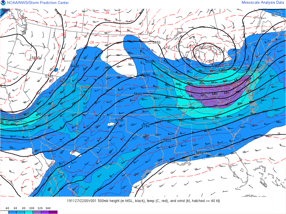
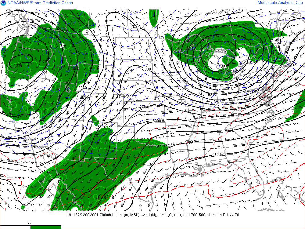
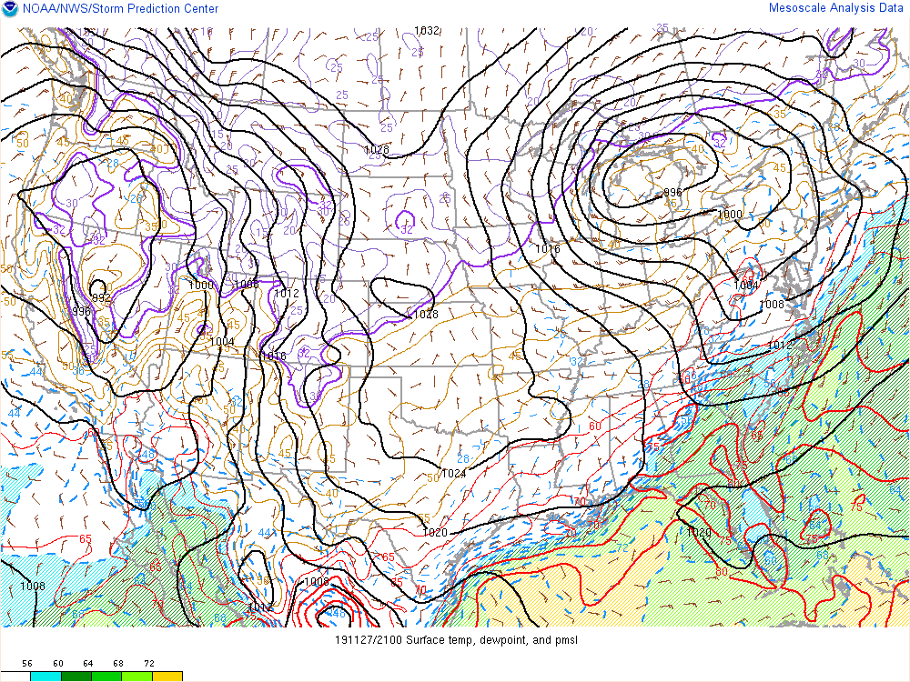
Environment
A strong low pressure system tracked east through the Central Plains, bringing heavy snow to much of the Dakotas and Minnesota
 |
 |
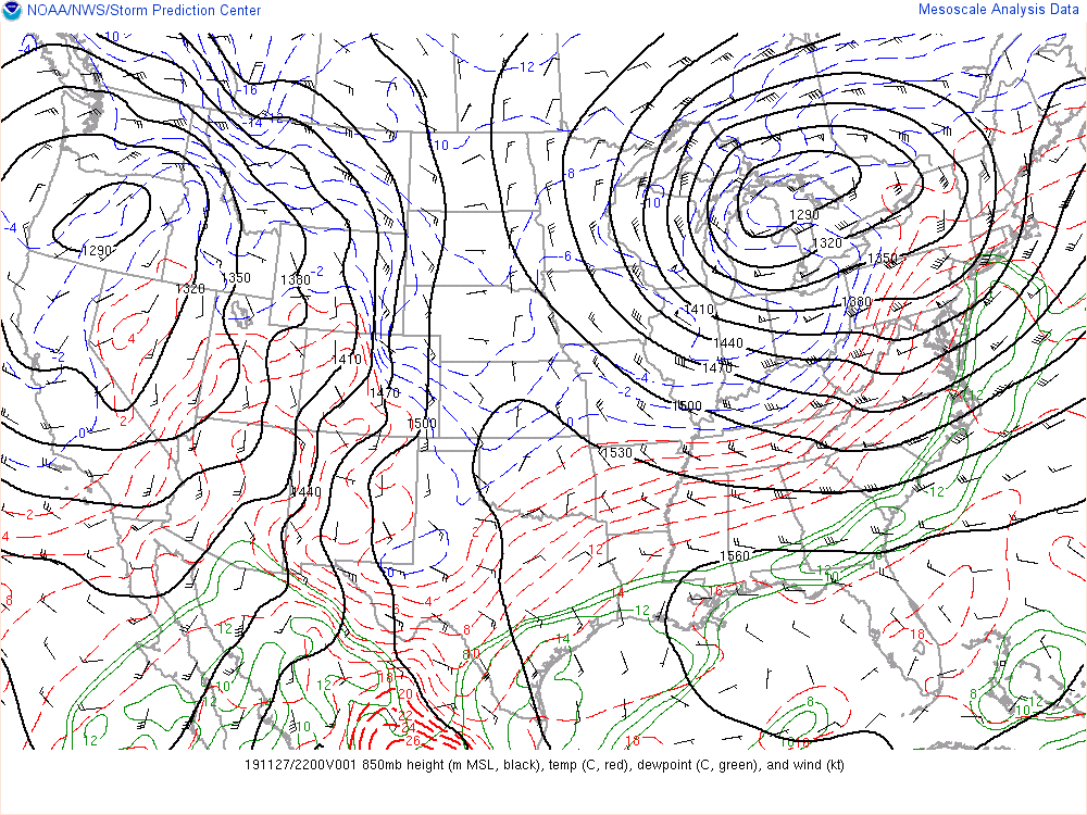 |
| Figure 1: 500 mb Analysis | Figure 2: 700 mb Analysis | Figure 3: 850 mb Analysis |
 |
 |
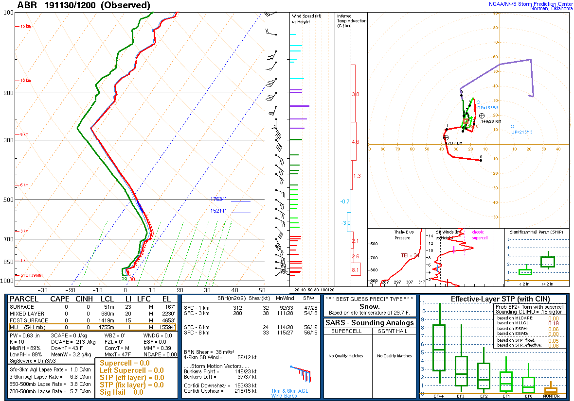 |
| Figure 4: Surface Analysis | Figure 5: Dendritic Growth Zone RH and Lift | Figure 6: 11/30/19 12 UTC sounding from Aberdeen, SD |
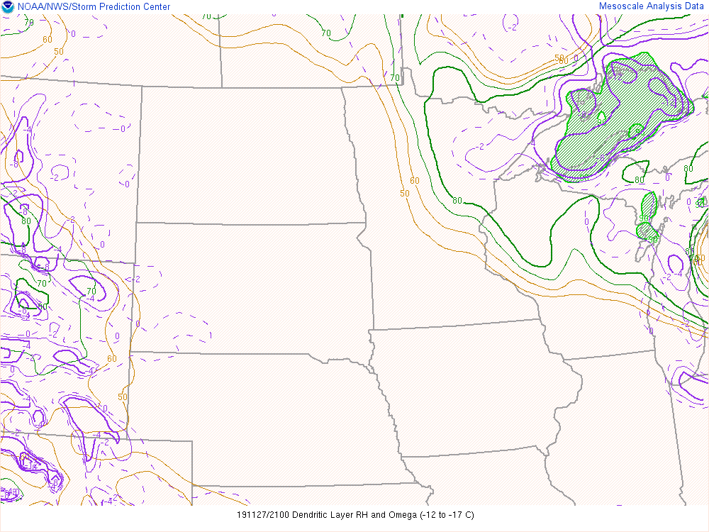
Satellite data
| Figure 7: | Figure 8: | Figure 9: |
 |
Media use of NWS Web News Stories is encouraged! Please acknowledge the NWS as the source of any news information accessed from this site. |
|

