Alabama Tornado Database |
|||||||||||
| 1965 Tornado Occurrences (9) | |||||||||||
| Tornado # of Year | Year | Month | Day | Time (CST) | County | Damage Scale | Path Length (Miles) | Maximum Path Width (Yards) | Fatalities | Injuries | Location |
| 9 | 1965 | 11 | 27 | 0300 | St. Clair | F2 | 14.5 | 10 | 0 | 0 | Moody - Pell City A tornado moved east from Moody to Pell City. At Moody, 2 barns were unroofed and many trees were damaged. Several homes were damaged in Pell City. Start: 33.60/-86.50 End: 33.60/-86.25 |
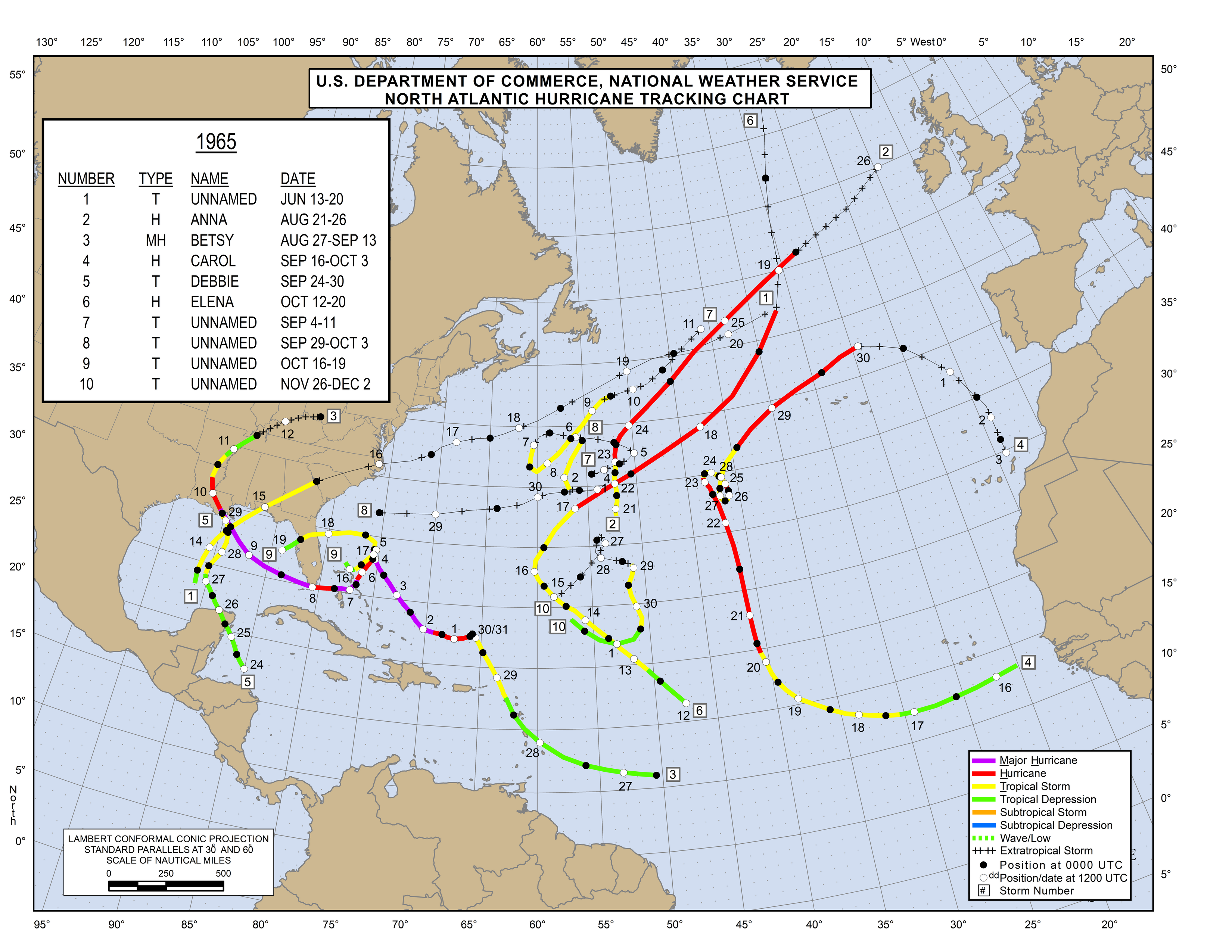
| 8 | 1965 | 9 | 29 | 2130 | Crenshaw Tropical Storm Debbie Information Tropical Storm Debbie Information Hurricane Map |
F2 | 0.1 | 10 | 0 | 2 | Centenary A tornado moved northward across Highway 10 and Black Rock Road. At least 3 homes were destroyed and 2 homes were damaged. Trees and power lines were also blown down. Start: 31.70/-86.22 End: 31.70/-86.22 |
| 7 | 1965 | 9 | 11 | 2000 | Cullman Hurricane Betsy Information Hurricane Betsy Information Hurricane Map |
F1 | 4.3 | 10 | 0 | 0 | Cullman Several buildings at St. Bernard College were damaged. Numerous trees were blown down and several acres of corn and fruit crops were destroyed. The tornado was associated with Hurricane Betsy. Start: 34.18/-86.83 End: 34.20/-86.77 |
| 6 | 1965 | 9 | 10 | 0001 | Mobile Hurricane Betsy Information Hurricane Betsy Information Hurricane Map |
F0 | 0.1 | 10 | 0 | 0 | Near Theodore A tornado touched down in a remote area with little to no damage reported. The tornado was associated with Hurricane Betsy. Start: 30.53/-88.13 End: 30.53/-88.13 |
| 5 | 1965 | 7 | 24 | 1330 | Bibb | F1 | 0.1 | 100 | 0 | 0 | Woodstock Several trees were snapped off 30 feet up and one automobile was damaged. Start: 33.22/-87.17 End: 33.22/-87.17 |
| 4 | 1965 | 4 | 15 | 1715 | Jackson-DeKalb | F3 | 9.6 | 50 | 0 | 2 | Blow Gourd-E Rosalie-S Ider-Sulphur Springs At least 20 homes and stores were destroyed and 200 additional structures were damaged. Timber damage was extensive. Start: 34.70/-85.75 End: 34.70/-85.58 |
| 3 | 1965 | 3 | 17 | 0730 | Colbert-Lauderdale-Limestone | F3 | 29.8 | 10 | 0 | 22 | Tuscumbia-Wilson Dam-SE Killen-Center Star-Anderson-Good Springs At least 60 homes were destroyed and 400 homes were damaged. Approximately 40 businesses and over 100 farm buildings were damaged or destroyed. Start: 34.75/-87.67 End: 34.95/-87.20 |
| 2 | 1965 | 2 | 11 | 1840 | Pickens Storm Report |
F3 | 1.5 | 100 | 0 | 18 | Aliceville At least 12 homes were demolished and 42 homes were damaged. A church, motel, and several commercial buildings were damaged. One farm suffered extensive damage. Start: 33.13/-86.16 End: 33.14/-86.14 |
| 1 | 1965 | 2 | 11 | 1710 | Colbert | F2 | 0.1 | 10 | 0 | 0 | Florence Several businesses suffered extensive damage and a gymnasium was heavily damaged. Minor damage to several houses occurred. Start: 34.83/-87.65 End: 34.83/-87.65 |

