.png)
SKYWARN is the National Weather Service (NWS) program of trained volunteer weather spotters. Storm spotters come from many walks of life, including firefighters, law enforcement, amateur radio operators, and the public. SKYWARN storm spotters provide important ground truth information to NWS meteorologists who make critical warning decisions during severe weather, and help the NWS perform its primary mission to save lives and property.
| Keep an Eye Out | What to Report |
|---|---|
| 🌩️ Cloud Features | Report: Rotating wall clouds, funnel clouds, and tornadoes. Important: Confirm rotation and report direction/distance. Do not get tricked by low-hanging scud or shelf clouds. |
| 💨 Damaging Winds | Report: What was damaged and the extent of damage. Indicators: Snapped/uprooted healthy trees, downed power poles/lines, structural damage. |
| 🧊 Hail | Report: Any size. Severe threshold is 1" (quarter-sized) or larger. Reference: Report the largest size. Use coins, sports balls, a ruler, or caliper for measurement. |
| 🌧️ Flooding | Report: Notable or unusual flooding only. Focus: Impassable roads, property/life threats, and rapidly rising waterways. |
| ❄️ Snow | Report: Depth of snow before any melting occurs. Essential: This one can be tricky due to factors that can result in inaccurate measurements, so it's best to be prepared before snow begins. Set up a board, such as plywood, baking sheet, cutting board, or storage bin lid, away from trees or structures. Place a marker so you can find it if snow-covered. You may be able to measure from the surface of an elevated deck or flat hand rail if the wind is light. The key is to avoid under-measuring due to melting on some types of surfaces or over-measuring by sticking a ruler into grass. Take the average of three measurements and round to the nearest tenth of an inch. ➡️ Tips |
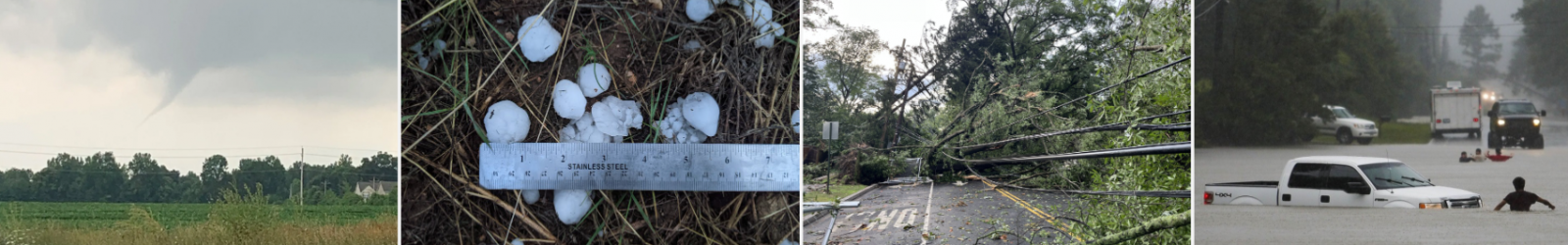
Reference imagery for real-time reporting. From left to right: Rotating Wall Cloud/Funnel Cloud/Tornado, Hail, Significant Wind/Wind Damage, and Flash Flooding.
| Date | Time (Central) | County / City | Location |
|---|---|---|---|
| Thursday, August 13, 2026 | 6:00 PM - 7:00 PM | Dallas / Selma | Wallace Community College Selma Hank Sanders Building - Room 112 |

