Heavy Rain Event...September 21-22, 2002
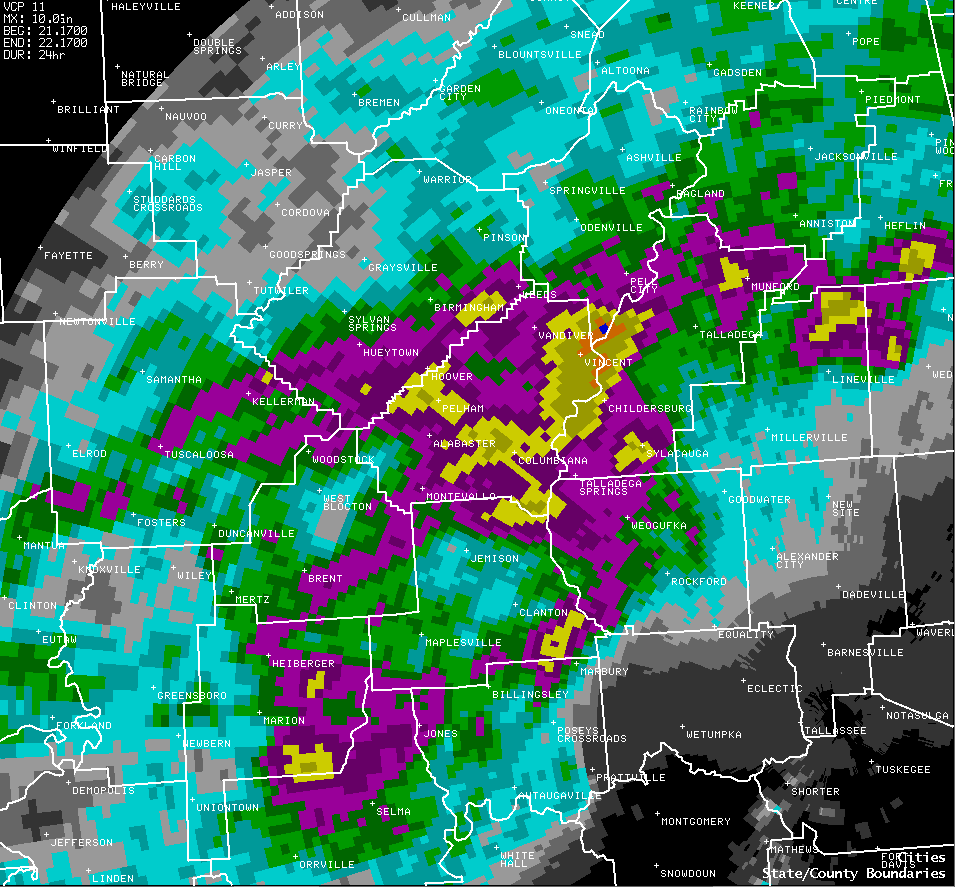
Many places across Alabama experiened drought like conditions this summer. Many phone calls came into the National Weather Service Office in Birmingham, with people asking "When is it going to rain? My yard is so dry." The combination of a slow moving cold front, abundant Gulf moisture, and upper level disturbances enhancing the effects of the cold front, caused significant rain to fall across most of North and Central Alabama on September 21st and 22nd. Most of the heavy rain fell across Central Alabama, in a band from from Tuscaloosa to Birmingham to Wedowee, along with isolated spots near Fort Payne and Selma. In these areas, rainfall amounts averaged 3 to 5 inches.
Maximum rainfall totals, as estimated by radar and verified by ground reports, occurred near Logan Martin Lake, where 10 to 12 inches of rain fell in a 24 hour period ending at noon Sunday, September 22.
Although most of North and Central Alabama received a good soaking, other places including Muscle Shoals, Huntsville, Montgomery, and Troy, received less than a half inch of rain. These areas remain well below normal on rainfall for the year.
The following table and picture show actual reported rainfall totals across North and Central Alabama, from both automated observing equipment and cooperative observers, for the 24 hour period ending at noon, Sunday, September 22, 2002 and the radar estimated precipitation from the event.
| Location | County | Rainfall (inches) |
| Logan Martin Dam | St. Clair/ Talladega | 10.96 |
| Vincent | Shelby | 8.19 |
| Mitchell Dam | Chilton/ Coosa | 7.64 |
| Wilsonville | Shelby | 7.75 |
| Childersburg | Talladega | 5.05 |
| Palmerdale | Jefferson | 5.03 |
| Varnons | Shelby | 4.71 |
| Calera | Shelby | 4.67 |
| Pinson | Jefferson | 4.50 |
| Fort Payne | DeKalb | 3.64 |
| Anniston | Calhoun | 3.60 |
| Geraldine | DeKalb | 3.56 |
| Bald Rock Mountain | St. Clair | 3.53 |
| Rockford | Coosa | 3.43 |
| Gadsden | Etowah | 3.41 |
| Birmingham Airport | Jefferson | 3.20 |
| Bridgeport | Jackson | 3.18 |
| Pell City | St. Clair | 3.12 |
| Ensley | Jefferson | 2.89 |
| Mt. Cheaha | Talladega | 2.70 |

| Radar Estimated Precipitation Map from September 22, 2002 |