La Crosse, WI
Weather Forecast Office
Fog in the river valleys is a common occurence across the region, but moreso during the late summer and fall months. Nights get longer, temperatures get cooler, and warm rivers exchange some moisture with the colder air right above it. The fog can be spectacular when viewed from above as fog "fills" the valleys while ridge-tops remain clear and sunny. These higher points will stick out like islands in this sea of white fog.
The recipe for a widespread valley fog event, or one that spreads the fog into even the most subtle river valleys, consists of:
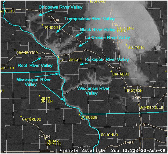
Below is a satellite picture of the region taken at 7:32 am August 23rd, 2009. Note the fog (the brighter grey) had developed into the tributaries of the Wisconsin and Mississippi River Valleys. This gives the fog a "vein"-like appearance from the satellite perspective. A large fog bank was located over central Wisconsin from Medford to Wautoma, and southeast toward Madison.
Below is a time lapse animated image from a fog event in September of 2009, showing just how quickly valley fog can dissipate. The time span is only 1 hour. Click image to make larger.

Our Office
Community Involvement
Station / Location Info
Follow Us On Social Media
Student Opportunities
Additional Information
Storm Summaries
Cooperative Observers
Educational Resources
Science / Research
Weather Phenomenon
Mayfly Tracking
Latest
Temp/Pcpn Summary
Precipitation Reports
Forecast Discussion
Hazardous Weather Outlook
Hourly Weather
Public Information Statement
Local Storm Report
Lightning Plot Archive
River Stages
Water Temp
Observations
Precipitation Plotter
Soil Temps
US Dept of Commerce
National Oceanic and Atmospheric Administration
National Weather Service
La Crosse, WI
711 County Road FA
La Crosse, WI 54601
608-784-7294
Comments? Questions? Please Contact Us.


 Weather Story
 Weather Map
 Local Radar