Overview
|
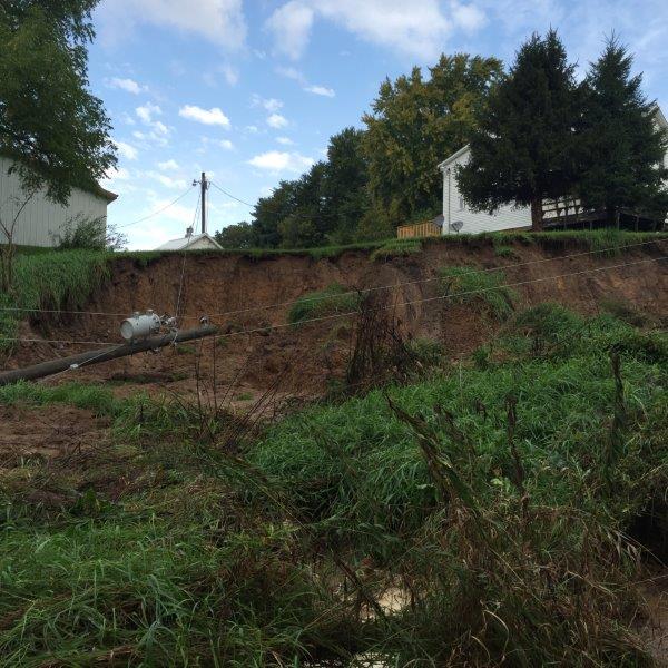
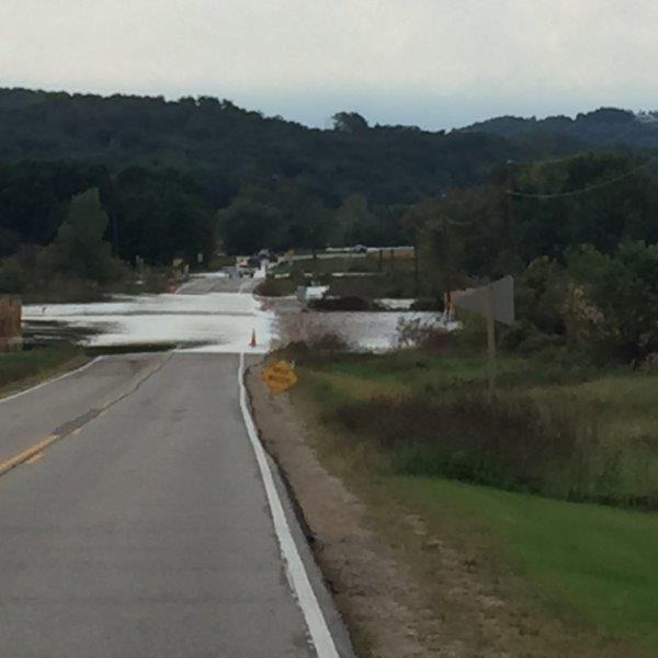
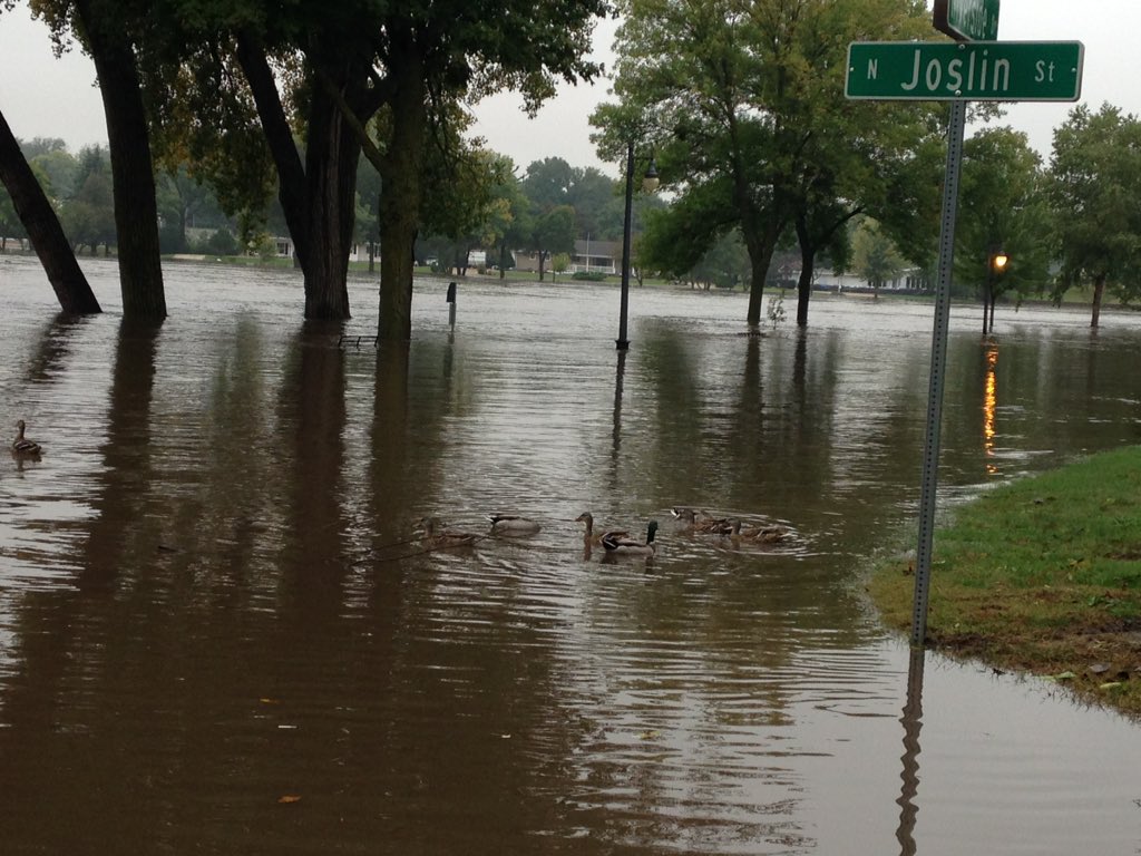
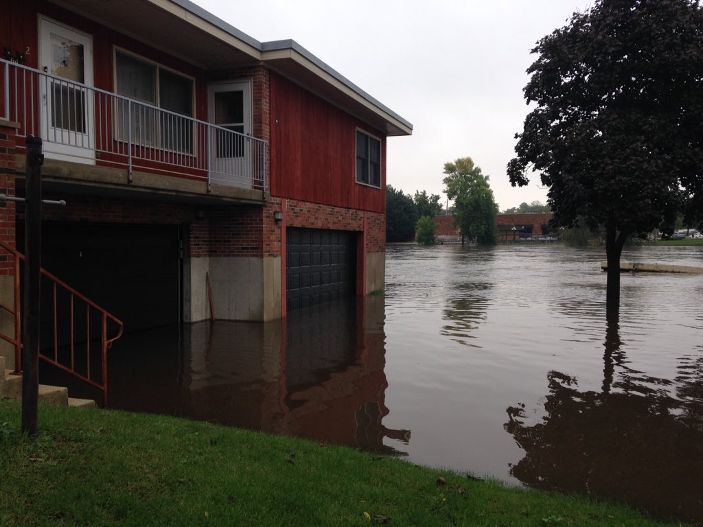
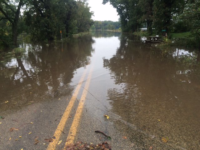
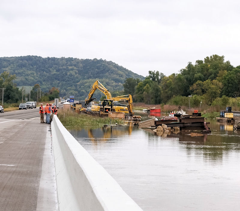
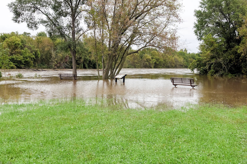
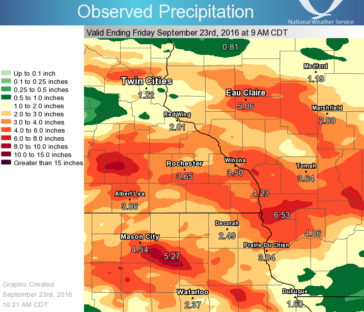
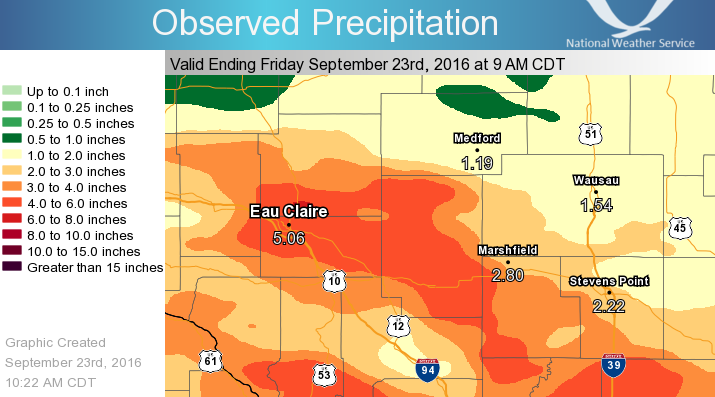
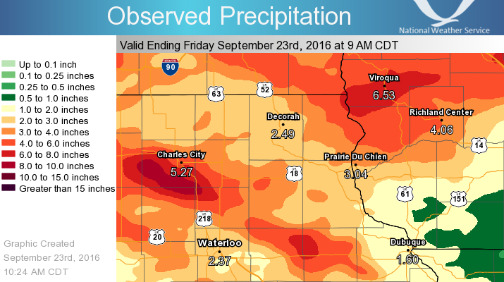
A tropical air mass shifted into the area Tuesday, September 20th and for days, interacted with a stationary front to produce numerous rounds of storms. The storms had heavy rainfall rates of 1-3 inches per hour and repeated over the same locations in some areas. Rainfall totals of 3-7 inches were reported across the entire area from Tuesday night through Friday morning. However, there were some localized much higher amounts of 9-11 inches. While 3-7 inches of rain can cause flooding, the unusual amount of rain that fell over the past month (2 to 3 times normal), created very wet soils and amplified the flooding. This water loading of the soils caused an unusually high number of mudslides. A high percentage of the rain that fell ran across the surface instead of soaking in, causing flooding on every river in the area. Damage to infrastructure (such as roads and bridges), farm crops, homes, and businesses was also widespread. |
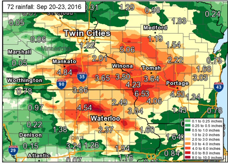 72 hour precipitation totals |
Flooding
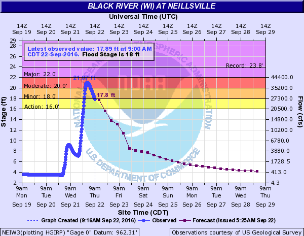
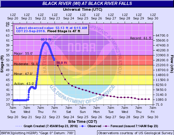
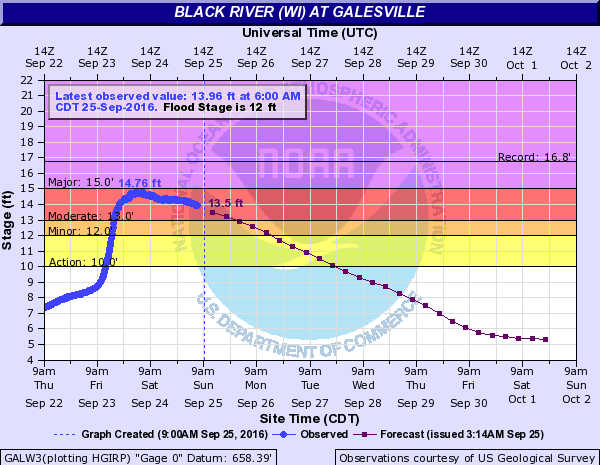
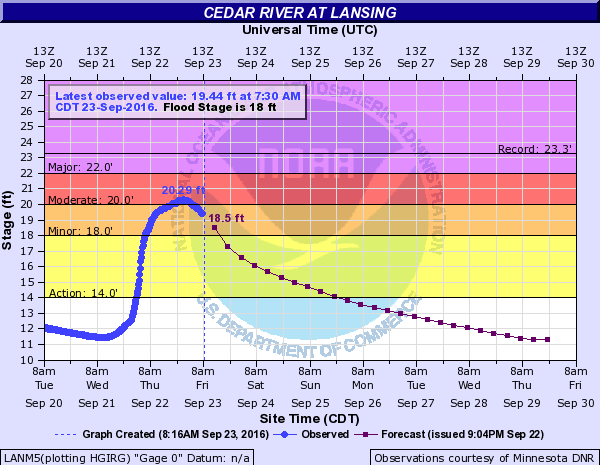
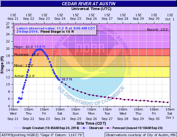
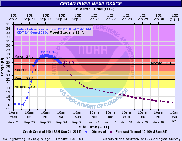
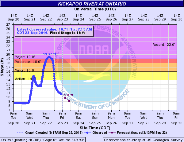
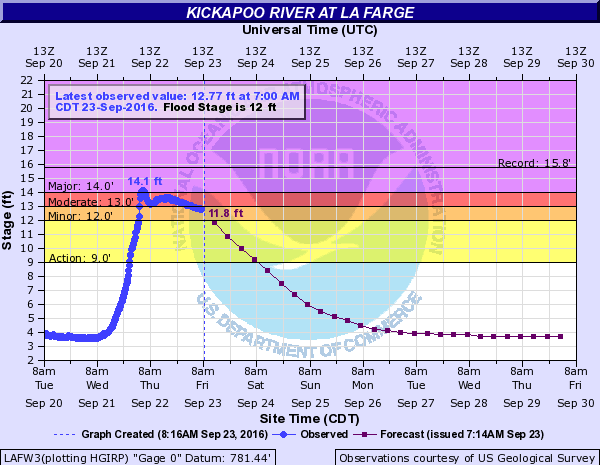
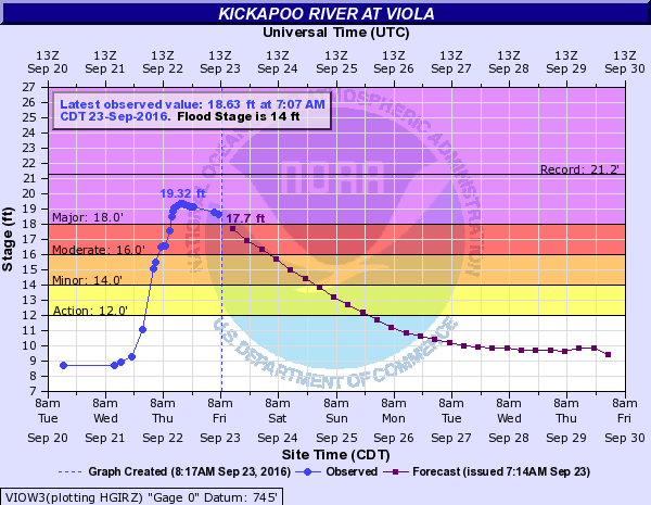
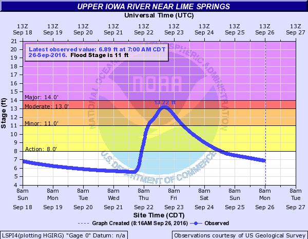
The following hydrographs below depict the peak crests at the various points along the various rivers.
Black River
 |
 |
 |
|
| Neillsville | Black River Falls | Galesville |
Cedar River
 |
 |
 |
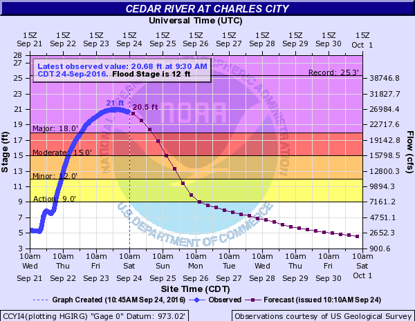 |
| Lansing | Austin | Osage | Charles City |
Kickapoo River
 |
 |
 |
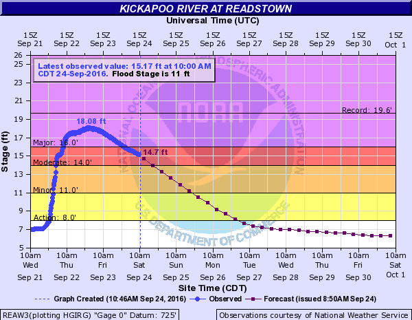 |
| Ontario | La Farge | Viola | Readstown |
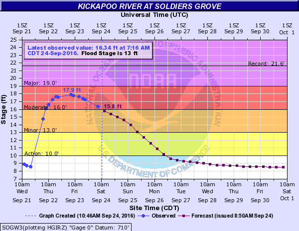 |
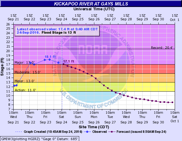 |
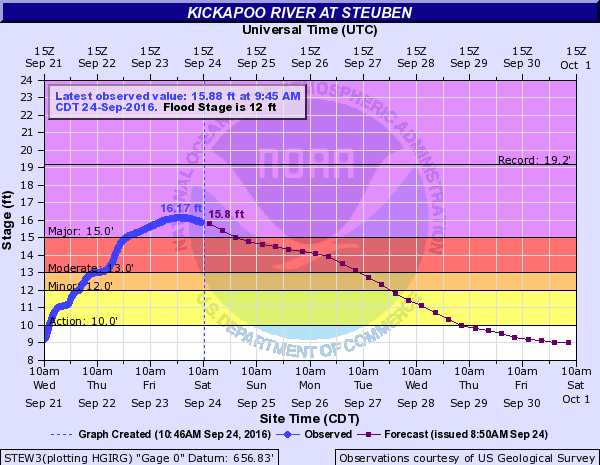 |
|
| Soldiers Grove | Gays Mills | Steuben |
Turkey River
 |
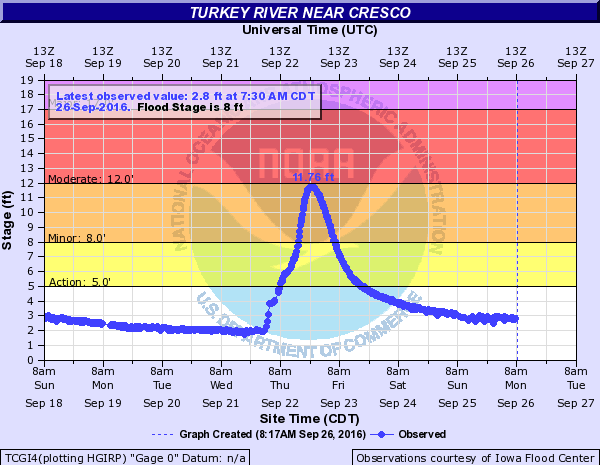 |
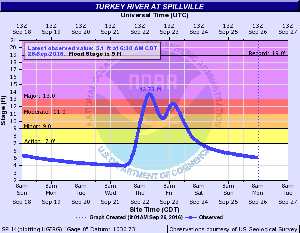 |
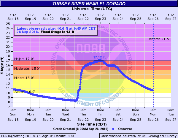 |
| Lime Springs | Cresco | Spillville | Eldorado |
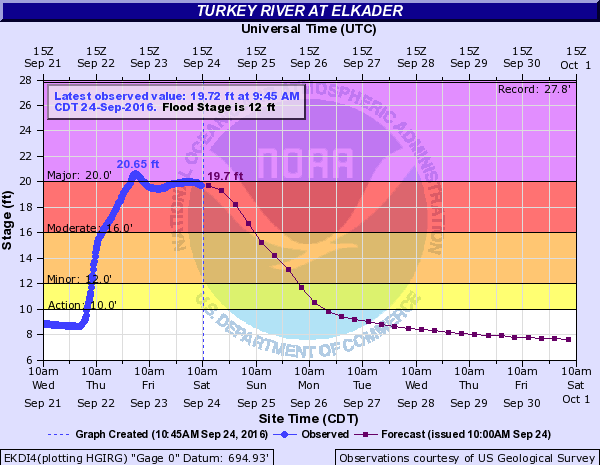 |
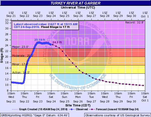 |
||
| Elkader | Garber |
Turtle Creek
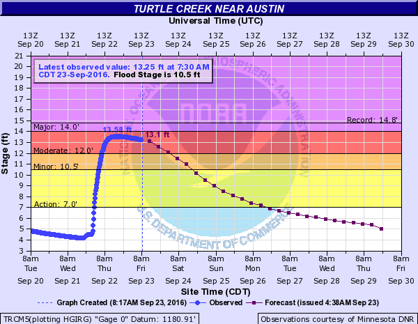 |
|||
| Near Austin |
Upper Iowa River
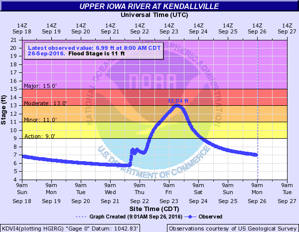 |
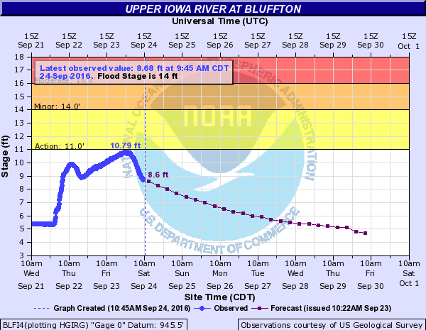 |
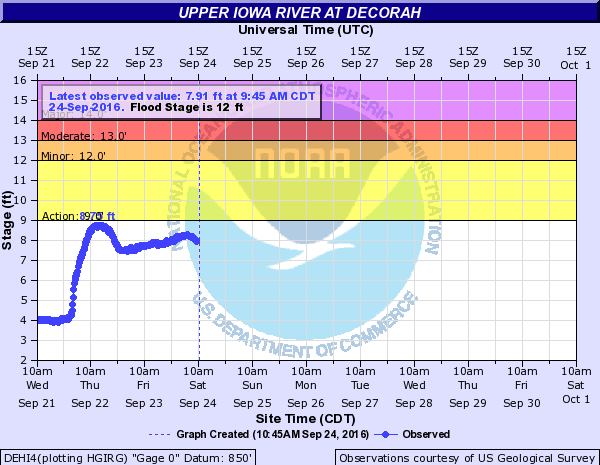 |
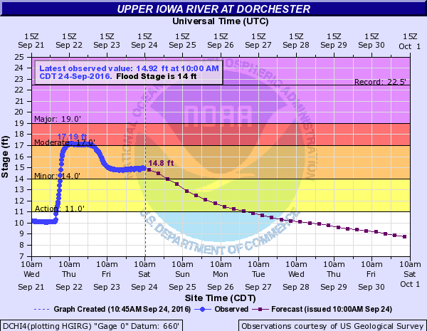 |
| Kendallville | Bluffton | Decorah | Dorchester |
Yellow River
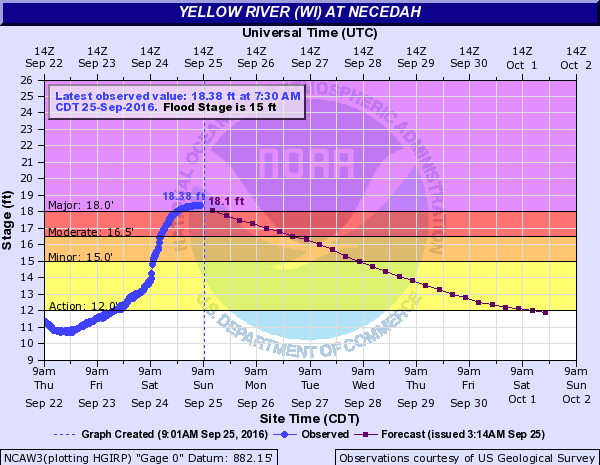 |
|||
| Necedah |
South Fork Zumbro River
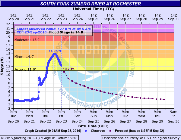 |
|||
| Rochester |
Records
Rainfall records set for September 21st.
| Location | State | Amount |
| ROCHESTER INTL AP | MN | 3.60 |
| SPARTA FT MCCOY | WI | 3.42 |
| TREMPEALEAU 1.8 NW | WI | 3.35 |
| LA CROSSE MUNI AP | WI | 3.17 |
| TOMAH RS 2 | WI | 2.85 |
| BOSCOBEL AP | WI | 2.79 |
| LA CROSSE WFO | WI | 2.68 |
| WINONA 3.8 SE | MN | 2.55 |
| GAYS MILLS | WI | 2.47 |
| WINONA MUNI AP | MN | 2.26 |
| MINNESOTA CITY DAM 5 | MN | 2.15 |
| AUSTIN MUNI AP | MN | 2.13 |
| PRESTONE FILLMORE AP | MN | 2.03 |
| SPARTA | WI | 1.87 |
| ELBA 4.7 SW | MN | 1.79 |
| STEWARTVILLE 5.1 W | MN | 1.72 |
| READSTOWN | WI | 1.72 |
| NE IOWA RGNL AP | IA | 1.71 |
| WINONA 5.1 WSW | MN | 1.71 |
| MABEL | MN | 1.69 |
| STOCKTON 0.1 SSE | MN | 1.69 |
| DORCHESTER HWY 76 | IA | 1.61 |
| CASHTON 3NNW | WI | 1.55 |
| CALEDONIA 5.4 S | MN | 1.53 |
| LAKE CITY | MN | 1.47 |
| SPRING GROVE 4N | MN | 1.35 |
| PRESTON 3.2 NNE | MN | 1.23 |
| WHALAN 3.3 SSE | MN | 1.20 |
| WILTON 4.2 E | WI | 1.20 |
| HOKAH 4NW | MN | 1.13 |
| LANESBORO 2NE | MN | 1.13 |
| TAYLOR CO AP | WI | 1.13 |
| NECEDAH 5 WNW | WI | 1.02 |
Rainfall records set for September 22nd.
| Location | State | Amount |
| NASHUA 2 SW | IA | 7.55 |
| LA FARGE | WI | 6.40 |
| CHARLES CITY | IA | 6.35 |
| IONIA 2 W | IA | 6.00 |
| READSTOWN 4NE | WI | 5.68 |
| HILLSBORO 2SW | WI | 5.61 |
| LANESBORO 2NE | MN | 5.34 |
| READSTOWN | WI | 5.09 |
| GAYS MILLS | WI | 4.38 |
| NEILLSVILLE 3 SW | WI | 4.13 |
| ROCHESTER AP 2NE | MN | 4.11 |
| WESTBY 3ENE | WI | 4.07 |
| PRESTON | MN | 3.81 |
| NEW HAMPTON | IA | 3.80 |
| SPRING GROVE 4N | MN | 3.74 |
| OWEN 3W | WI | 3.74 |
| SPRING VALLEY | MN | 3.70 |
| GRAND MEADOW | MN | 3.70 |
| CASHTON 3NNW | WI | 3.70 |
| GENOA DAM 8 | WI | 3.68 |
| NE IOWA RGNL AP | IA | 3.65 |
| CLERMONT | IA | 3.65 |
| ST ANSGAR | IA | 3.64 |
| TREMPEALEAU DAM 6 | WI | 3.62 |
| CALEDONIA | MN | 3.61 |
| FRIENDSHIP | WI | 3.45 |
| OSAGE | IA | 3.44 |
| ONTARIO | WI | 3.41 |
| STEUBEN 4 SE | WI | 3.39 |
| ELMA | IA | 3.34 |
| LYNXVILLE DAM 9 | WI | 3.34 |
| SPARTA | WI | 3.32 |
| CALMAR NE | IA | 3.23 |
| DECORAH | IA | 3.22 |
| THEILMAN | MN | 3.08 |
| OELWEIN MUNI AP | IA | 3.00 |
| WAUCOMA 1WNW | IA | 3.00 |
| DODGE CTR | MN | 2.91 |
| HOKAH WWTP | MN | 2.87 |
| NECEDAH 5 WNW | WI | 2.86 |
| HOUSTON 1 N | MN | 2.83 |
| LA CRESCENT DAM 7 | MN | 2.75 |
| HARMONY | MN | 2.68 |
| MAUSTON 1 SE | WI | 2.67 |
| BYRON | MN | 2.62 |
| ROCHESTER RIVER | MN | 2.61 |
| FAYETTE | IA | 2.56 |
| PINE ISLAND 1S | MN | 2.52 |
| MABEL | MN | 2.52 |
| PRAIRIE DU CHIEN | WI | 2.52 |
| HOKAH 4NW | MN | 2.50 |
| ALMA DAM 4 | WI | 2.45 |
| DORCHESTER HWY 76 | IA | 2.41 |
| MINNESOTA CITY DAM 5 | MN | 2.31 |
| LAKE CITY | MN | 2.14 |
| WINONA DAM 5 A | MN | 2.10 |
| ELGIN 2SSW | MN | 2.09 |
| DECORAH MUNI AP | IA | 2.07 |
| PRAIRIE DU CHIEN AP | WI | 1.89 |
| MONDOVI | WI | 1.79 |
| BOSCOBEL AP | WI | 1.71 |
| LA CROSSE WFO | WI | 1.60 |
| BLACK RIVER FALLS SWG | WI | 1.49 |
| SPARTA FT MCCOY | WI | 1.26 |
| WINONA MUNI AP | MN | 1.14 |
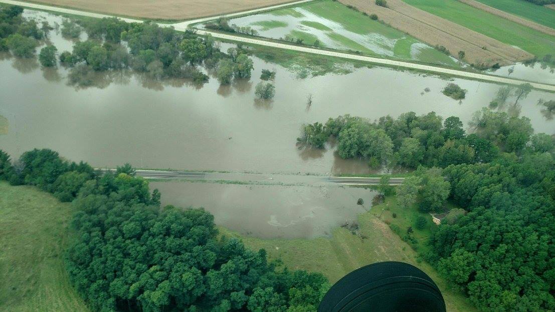
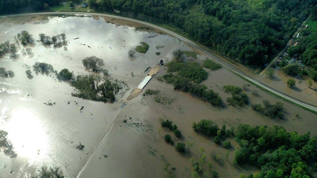
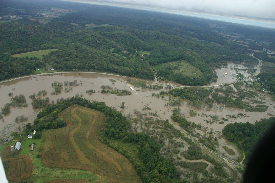
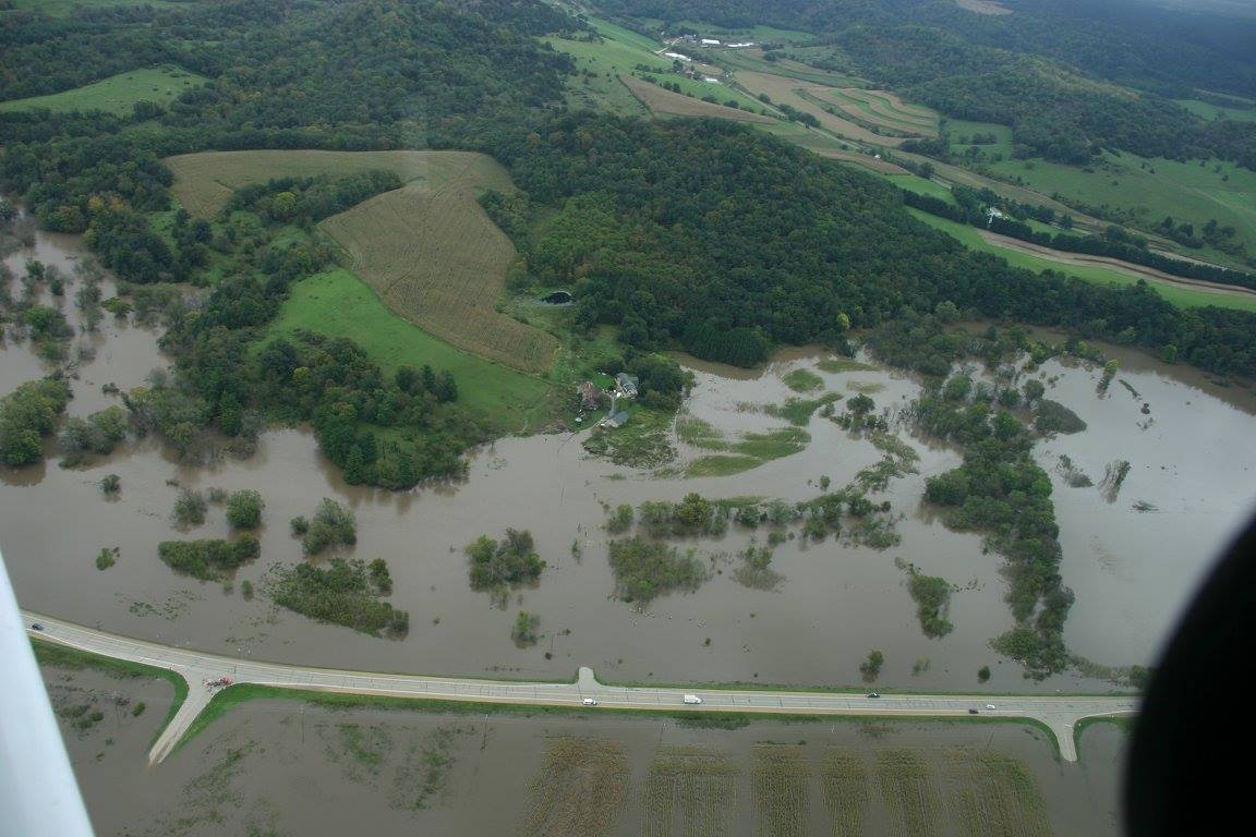
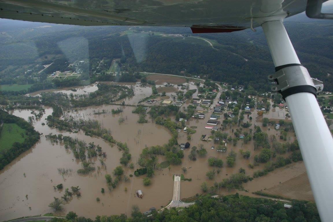
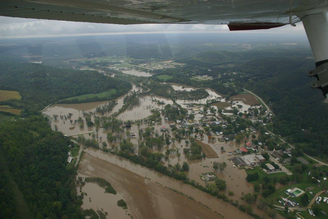
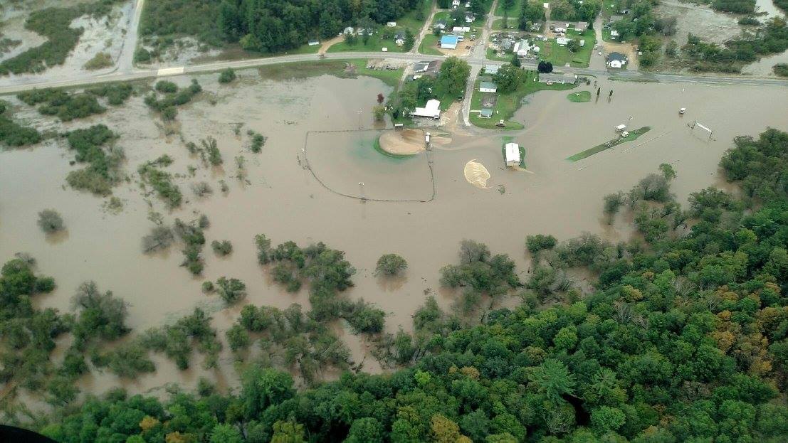
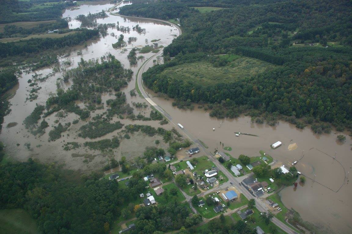
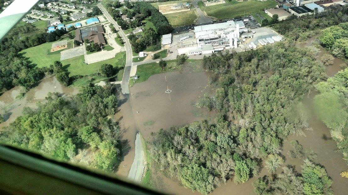
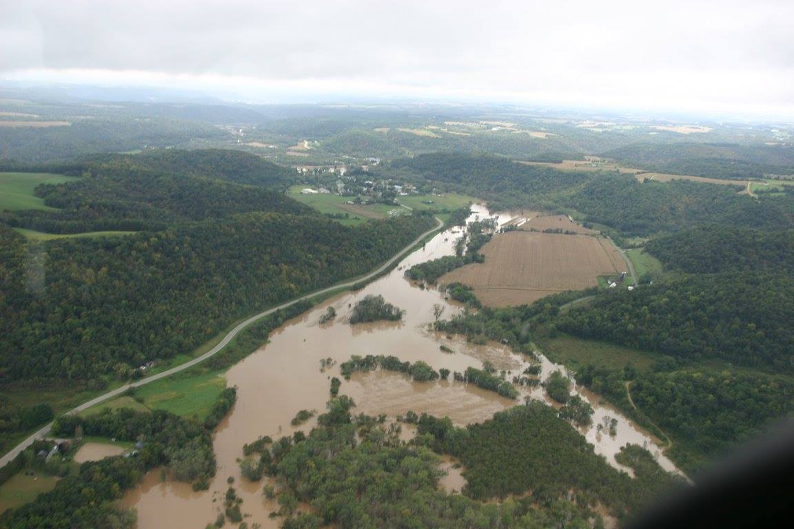
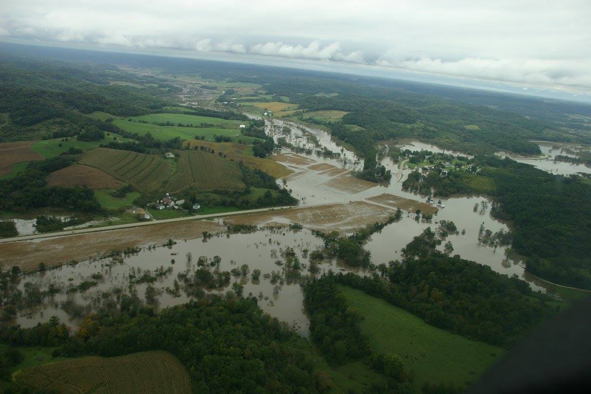
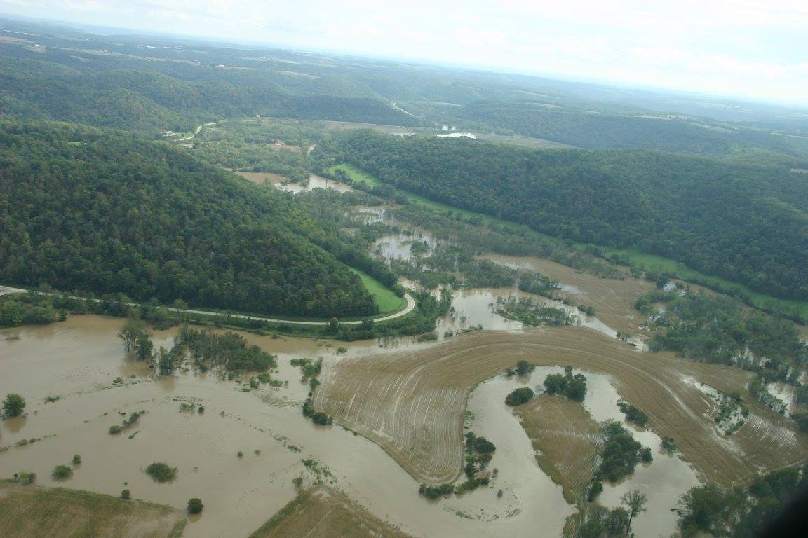
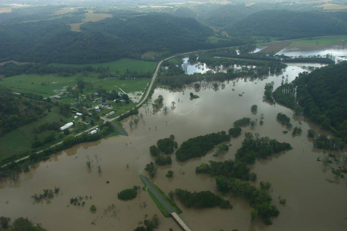
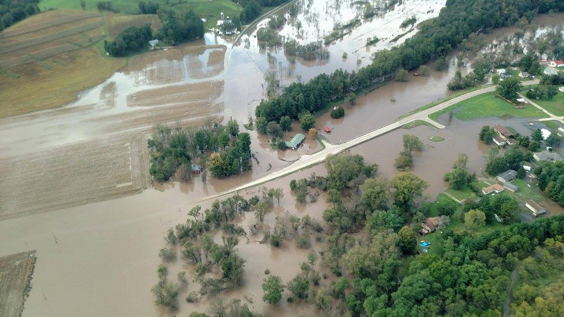
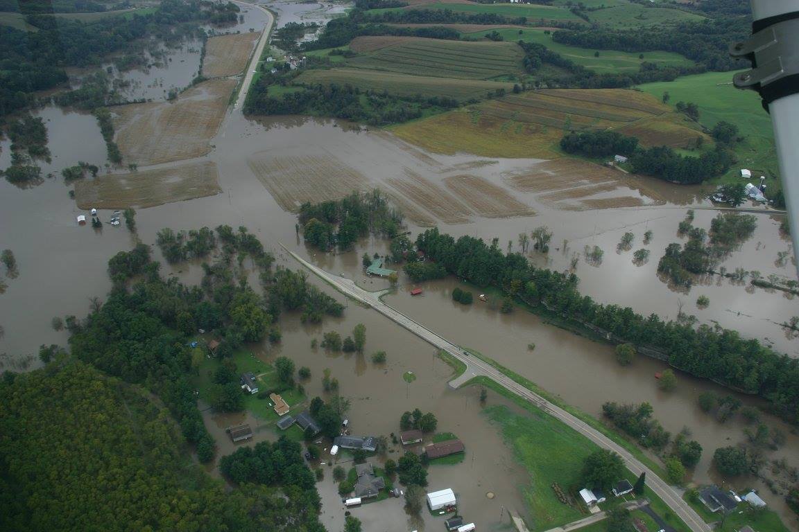
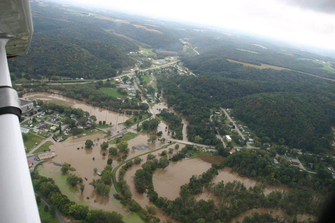
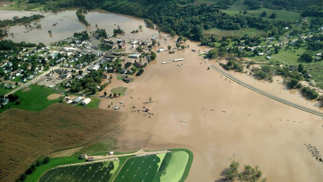
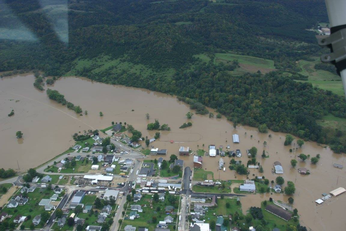
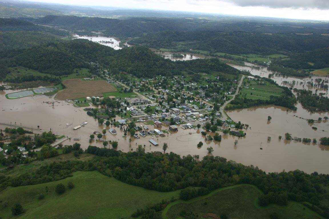
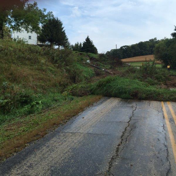
Photos:
Aerial
All images in this "Aerial" section courtesy of the Richland County, WI Emergency Management. Special thanks to Luke Clements, Mike Kauffman, and the Buena Vista Flying Club
 |
 |
 |
 |
| County Rd SR | County Rd I & HWY 80 | County Rd I & HWY 80 | HWY 80 |
 |
 |
 |
 |
| Gays Mills - Kickapoo River | Gays Mills - Kickapoo River | Hub City - Pine River | Hub City - Pine River |
 |
 |
 |
 |
| Richland Center | Richland County | Richland County | Richland County |
 |
 |
 |
 |
| Richland County | Rockbridge - Pine River | Rockbridge - Pine River | Soldiers Grove - Kickapoo River |
 |
 |
 |
|
| Viola - Kickapoo River | Viola - Kickapoo River | Viola - Kickapoo River |
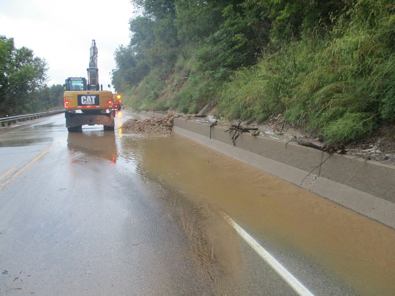
Other
 |
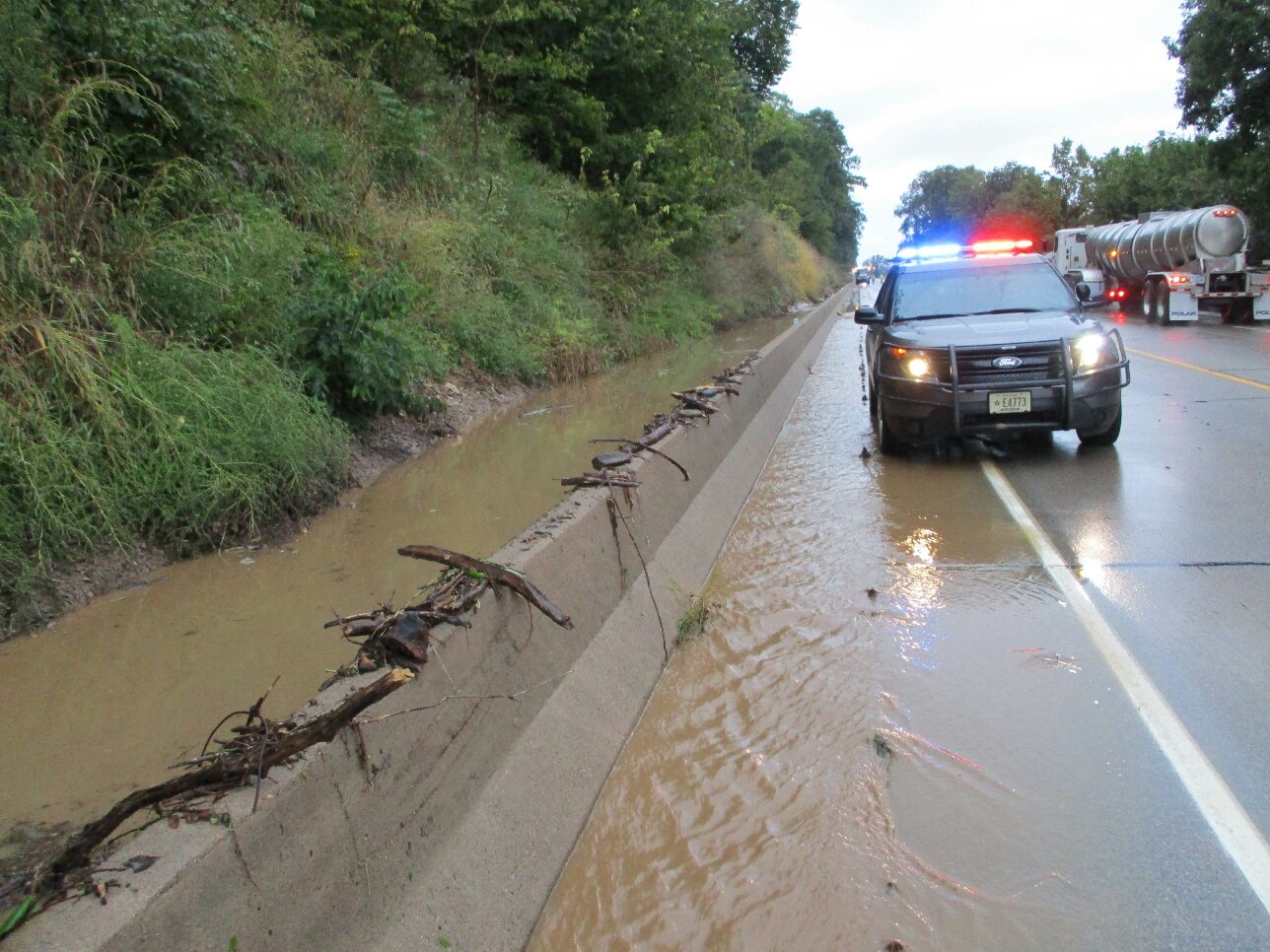 |
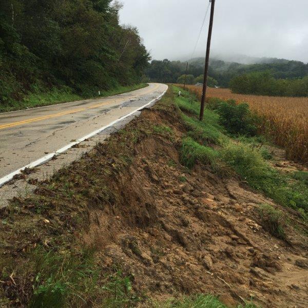 |
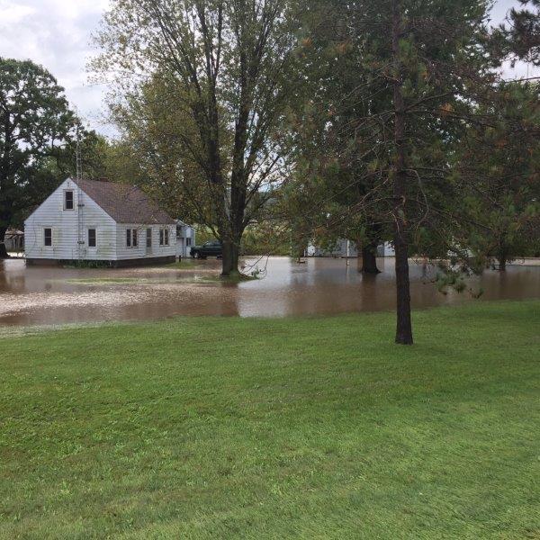 |
| Ferryville, WI HWY 35 (source: ReadyWisconsin) |
Ferryville, WI HWY 35 (source: ReadyWisconsin) |
Northeast La Crosse Co, WI (source: La Crosse Co EM) |
Northeast La Crosse Co, WI (source: La Crosse Co EM) |
 |
 |
 |
 |
| Northeast La Crosse Co, WI (source: La Crosse Co EM) |
Northeast La Crosse Co, WI (source: La Crosse Co EM) |
Northeast La Crosse Co, WI (source: La Crosse Co EM) |
Charles City, IA (source: Globalgazette.com) |
 |
 |
 |
 |
| Charles City, IA (source: Globalgazette.com) |
HWY 105 Austin, MN (source: MNDOT) |
Near La Crescent, MN - Root River (source: Dan McKenzie) |
Near La Crescent, MN - Root River (source: Dan McKenzie) |
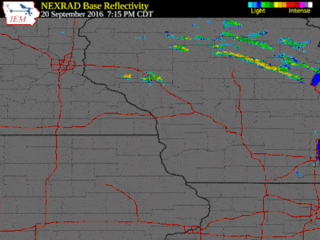
Radar:
 |
|||
| Radar loop for September 21-22, 2016 |
Rain Reports
 |
 |
 |
| 72 hour rainfall totals | 72 hour rainfall - North | 72 hour rainfall - South |
Below are the 2 day rainfall reports spanning from September 21st-22nd, when the heaviest and most widespread rain fell. A stripe of heavy rain fell across portions of northeast Iowa the night of the 22nd, but generally impacted areas that did not receive the heavy rain from the previous 48 hour period. Rainfall totals for Tuesday night-Friday morning are found at the bottom (3 Day Totals).
2 Day Rainfall Reports
Public Information Statement
National Weather Service La Crosse WI
440 PM CDT Thu Sep 22 2016

...2-day Rainfall Reports...

Location                     Amount    Time/Date       Lat/Lon

...Iowa...

...Allamakee County...
3 S Dorchester               4.23 in   0400 PM 09/22   43.42N/91.51W
4 ENE Watson                 4.01 in   0345 PM 09/22   43.11N/91.26W
3 SE Waterville              3.82 in   0407 PM 09/22   43.17N/91.24W

...Chickasaw County...
Ionia 2W                     6.24 in   0645 AM 09/22   43.03N/92.50W
New Hampton                  3.62 in   0654 AM 09/22   43.06N/92.32W

...Clayton County...
Elkader Turkey River         1.45 in   0345 PM 09/22   42.84N/91.40W
Marquette-Bloody Run Creek   0.94 in   0400 PM 09/22   43.04N/91.21W
Littleport                   0.89 in   0345 PM 09/22   42.75N/91.37W
Garber                       0.70 in   0315 PM 09/22   42.74N/91.26W
Guttenberg Dam 10            0.17 in   0600 AM 09/22   42.78N/91.10W

...Fayette County...
1 ENE Alpha                  3.32 in   0635 AM 09/22   43.01N/92.03W
Waucoma 1WNW                 3.00 in   0700 AM 09/22   43.06N/92.05W
Fayette                      2.56 in   0700 AM 09/22   42.85N/91.82W
Fayette-CWOP                 1.20 in   0602 AM 09/22   42.84N/91.80W

...Floyd County...
Powersville 1N              11.25 in   0700 AM 09/22
Nora Springs 2SSE            9.36 in   0700 AM 09/22
Nashua 2sw                   7.55 in   0630 AM 09/22   42.94N/92.57W
Charles City                 6.35 in   0700 AM 09/22   43.06N/92.67W
Charles City-Cedar River     5.64 in   0230 PM 09/22   43.06N/92.67W
Colwell                      4.10 in   0700 AM 09/22   43.16N/92.59W

...Howard County...
3 NE Riceville               4.62 in   0405 PM 09/22   43.40N/92.50W
Elma                         3.34 in   0700 AM 09/22   43.24N/92.44W
Cresco 1NE                   2.70 in   0700 AM 09/22   43.39N/92.09W

...Mitchell County...
St Ansgar                    3.64 in   0630 AM 09/22   43.38N/92.92W
Osage                        3.44 in   0700 AM 09/22   43.28N/92.81W

...Winneshiek County...
Fort Atkinson                3.40 in   0700 AM 09/22   43.14N/91.93W
Calmar NE                    3.23 in   0700 AM 09/22   43.19N/91.86W
5 ESE Decorah                2.93 in   0700 AM 09/22   43.26N/91.70W
Decorah 6ese                 2.79 in   0700 AM 09/22   43.27N/91.68W
Decorah Municipal Airport    2.31 in   0655 AM 09/22   43.28N/91.74W

...Minnesota...

...Dodge County...
2 E Claremont                4.41 in   0800 AM 09/22   44.04N/92.95W
Mantorville                  4.22 in   0700 AM 09/22   44.07N/92.77W
Claremont 2.5 SSE            3.64 in   0700 AM 09/22   44.01N/92.99W
Dodge Center                 3.47 in   0700 AM 09/22   44.03N/92.87W

...Fillmore County...
Lanesboro 2NE                6.47 in   0700 AM 09/22   43.73N/91.94W
Lanesboro-Root River         5.55 in   0330 PM 09/22   43.72N/91.98W
1 SSE Pilot Mound            5.51 in   0700 AM 09/22   43.79N/92.03W
Whalan 3.3 SSE               5.12 in   0700 AM 09/22   43.69N/91.90W
1 W Fillmore                 4.91 in   0700 AM 09/22   43.74N/92.31W
Fillmore                     4.85 in   0330 PM 09/22   43.76N/92.27W
Preston                      4.68 in   0700 AM 09/22   43.66N/92.08W
Pilot Mound-Root River       4.59 in   0400 PM 09/22   43.78N/92.03W
Spring Valley 3E             3.41 in   0700 AM 09/22   43.68N/92.33W
Preston 6s                   3.07 in   0230 PM 09/22   43.59N/92.11W
Preston Airport              2.92 in   0654 AM 09/22   43.68N/92.18W

...Houston County...
4 NW Eitzen                  5.10 in   0800 AM 09/22   43.56N/91.51W
Spring Grove 4n              5.09 in   0700 AM 09/22   43.61N/91.62W
Caledonia                    4.50 in   0700 AM 09/22   43.63N/91.50W
1 SE Mound Prairie           3.79 in   0730 AM 09/22   43.76N/91.43W
Hokah WWTP                   3.69 in   0700 AM 09/22   43.76N/91.35W
Houston                      3.45 in   0345 PM 09/22   43.77N/91.57W
Mound Prairie                2.74 in   0345 PM 09/22   43.78N/91.45W

...Mower County...
Austin 3S                    4.32 in   0400 PM 09/22   43.64N/92.97W
Austin 3 NW - Turtle Creek   3.94 in   0330 PM 09/22   43.65N/92.98W
Austin 2NE-Dobbins Creek     3.77 in   0330 PM 09/22   43.67N/92.95W
Grand Meadow                 3.72 in   0600 AM 09/22   43.71N/92.56W
Ostrander 5wnw               3.16 in   0230 PM 09/22   43.63N/92.53W

...Olmsted County...
Eyota 2NE                    6.20 in   0330 PM 09/22   44.01N/92.20W
2 N Rock Dell                5.67 in   0800 AM 09/22   43.96N/92.63W
Rochester Ap 2ne             5.02 in   0700 AM 09/22   43.93N/92.48W
2 W High Forest              4.49 in   0500 AM 09/22   43.85N/92.59W
Rochester International Airp 4.31 in   0654 AM 09/22   43.91N/92.50W
1 W Chester                  4.30 in   0630 AM 09/22   44.00N/92.38W
Rochester-Beltline           4.14 in   0330 PM 09/22   44.01N/92.47W
Rochester-Beltline Bear Cree 3.60 in   0330 PM 09/22   44.01N/92.45W
2 ENE Rochester              3.56 in   0330 PM 09/22   44.03N/92.43W
Rochester-Cascade Creek      3.54 in   0330 PM 09/22   44.03N/92.47W
Mayo Helipad                 3.52 in   0654 AM 09/22   44.02N/92.48W
Byron                        3.51 in   0403 PM 09/22   44.04N/92.64W
Rochester 3W                 3.42 in   0330 PM 09/22   44.02N/92.53W
Byron                        3.33 in   0411 PM 09/22   44.03N/92.66W
2 NE Rochester               3.33 in   0600 AM 09/22   44.04N/92.44W
2 NE Rochester               3.27 in   0406 PM 09/22   44.04N/92.44W
4 NNW Rochester              2.93 in   0700 AM 09/22   44.07N/92.49W
Oronoco 1W                   2.89 in   0330 PM 09/22   44.17N/92.55W
Byron 4 North                2.85 in   0700 AM 09/22   44.09N/92.64W
Pine Island 1S               2.83 in   0400 PM 09/22   44.19N/92.65W
3 N Rochester                2.81 in   0315 PM 09/22   44.06N/92.47W
Oxbow Park Alert Gage        2.73 in   0400 PM 09/22   44.09N/92.64W
3 NE Rochester               2.62 in   0415 PM 09/22   44.05N/92.45W
Elgin 5SE                    2.61 in   0330 PM 09/22   44.01N/92.11W
5 E Douglas                  2.53 in   1000 AM 09/22   44.10N/92.47W
Oronoco                      2.51 in   0330 PM 09/22   44.16N/92.54W
Elgin 2ssw                   2.45 in   0700 AM 09/22   44.10N/92.27W
4 ESE Douglas                2.27 in   0402 PM 09/22   44.09N/92.49W
3 SW Hammond                 2.15 in   0412 PM 09/22   44.18N/92.41W
3 ESE Douglas                2.11 in   0415 PM 09/22   44.09N/92.51W
2 SE Douglas                 2.11 in   0414 PM 09/22   44.08N/92.55W

...Wabasha County...
Plainview                    4.47 in   0412 PM 09/22   44.17N/92.17W
Theilman 1SSW                3.41 in   0800 AM 09/22   44.28N/92.19W
Lake City                    3.12 in   0403 PM 09/22   44.45N/92.27W
Wabasha                      3.03 in   0700 AM 09/22   44.38N/92.05W
Mazeppa 3ESE                 2.98 in   0330 PM 09/22   44.26N/92.49W
Kellogg-Zumbro River         2.96 in   0400 PM 09/22   44.32N/92.00W
2 NNW Zumbro Falls           2.85 in   0348 PM 09/22   44.32N/92.44W

...Winona County...
Minnesota City Dam 5         4.46 in   0700 AM 09/22   44.16N/91.81W
Whitewater State Park Group  3.86 in   0330 PM 09/22   44.06N/92.05W
Winona Dam 5A                3.78 in   0600 AM 09/22   44.09N/91.67W
La Crescent Dam 7            3.75 in   0600 AM 09/22   43.87N/91.31W
Whitewater State Park        3.73 in   0330 PM 09/22   44.05N/92.05W
1 E Winona                   3.26 in   0415 PM 09/22   44.05N/91.63W
Elba                         3.23 in   0345 PM 09/22   44.09N/92.03W
4 NNE Elba                   3.16 in   0345 PM 09/22   44.15N/92.00W

...Wisconsin...

...Adams County...
Oxford 3SE                   8.20 in   0900 AM 09/22
Castle Rock                  5.03 in   0830 AM 09/22   43.87N/89.95W
Friendship                   3.92 in   0700 AM 09/22   43.98N/89.83W

...Buffalo County...
Alma Dam 4                   3.21 in   0600 AM 09/22   44.33N/91.92W

...Clark County...
Neillsville 1W               6.77 in   0300 PM 09/22   44.56N/90.61W
Neillsville 3ese             5.64 in   0700 AM 09/22   44.54N/90.53W
Owen 2N                      4.02 in   0800 AM 09/22   44.98N/90.55W

...Crawford County...
Steuben                      6.07 in   0345 PM 09/22   43.18N/90.86W
De Soto                      5.30 in   0216 AM 09/22   43.42N/91.19W
Ferryville 1se               5.11 in   0700 AM 09/22   43.33N/91.07W
Ferryville                   5.11 in   0700 AM 09/22   43.33N/91.07W
Lynxville Dam 9              4.04 in   0600 AM 09/22   43.21N/91.10W
1 WNW Mount Zion             3.85 in   0700 AM 09/22   43.26N/90.76W
Prairie Du Chien             2.77 in   0700 AM 09/22   43.05N/91.13W
Prairie Du Chien  Airport    2.01 in   0655 AM 09/22   43.02N/91.12W

...Grant County...
Boscobel Airport             4.23 in   0653 AM 09/22   43.16N/90.67W
1 ENE Boscobel               4.16 in   0403 PM 09/22   43.15N/90.68W
Muscoda                      2.38 in   0345 PM 09/22   43.20N/90.44W
Platteville Municipal Airpor 0.61 in   0655 AM 09/22   42.69N/90.44W
Lancaster 4wsw               0.47 in   0745 AM 09/22   42.83N/90.79W
Platteville                  0.39 in   0700 AM 09/22   42.74N/90.47W

...Jackson County...
Mather 3nw                   3.11 in   0700 AM 09/22   44.17N/90.35W
Black River Falls 1.7 NNE    2.01 in   0700 AM 09/22   44.32N/90.83W
1 E Black River Falls        1.72 in   0415 PM 09/22   44.30N/90.83W
Black River Falls Sewage     1.65 in   0830 AM 09/22   44.29N/90.85W
Black River Falls-black Rive 1.37 in   0715 AM 09/22   44.28N/90.87W

...Juneau County...
Volk Field                   5.31 in   0658 AM 09/22   43.94N/90.25W
Necedah                      5.28 in   0348 PM 09/22   44.03N/90.08W
2 N Cloverdale               4.08 in   0410 PM 09/22   44.06N/90.17W
2 WNW Dellwood               3.67 in   0410 PM 09/22   44.00N/89.99W
Mauston                      2.91 in   0412 PM 09/22   43.80N/90.07W

...La Crosse County...
West Salem                   5.01 in   0700 AM 09/22   43.90N/91.09W
Bangor                       4.96 in   1000 AM 09/22
Holmen 2s                    4.78 in   0700 AM 09/22   43.93N/91.25W
La Crosse Regional Airport   4.55 in   0653 AM 09/22   43.88N/91.26W
La Crosse Weather Office     4.11 in   0600 AM 09/22   43.82N/91.19W

...Monroe County...
Cashton 3NNW                 5.25 in   0746 AM 09/22   43.79N/90.80W
Sparta                       5.19 in   0800 AM 09/22   43.94N/90.82W
Sparta/Fort McCoy Airport    4.54 in   0655 AM 09/22   43.96N/90.74W
Four Corners                 3.96 in   0700 AM 09/22   44.09N/90.91W
Fort Mccoy- Stillwell Creek  3.74 in   0715 AM 09/22   44.00N/90.68W
3 WNW Kendall                3.45 in   0700 AM 09/22   43.81N/90.44W
Tunnel City                  3.44 in   0700 AM 09/22   44.01N/90.57W
4 W Valley Junction          2.83 in   0700 AM 09/22   44.06N/90.50W

...Richland County...
Richland Center 4N           4.73 in   0700 AM 09/22   43.40N/90.39W
3 NW Avoca                   1.53 in   0407 PM 09/22   43.23N/90.37W

...Taylor County...
3 NE Lublin                  2.07 in   0414 PM 09/22   45.11N/90.69W
Medford Airport              1.27 in   0655 AM 09/22   45.10N/90.30W
Jump River 1 NW              0.99 in   0700 AM 09/22   45.36N/90.80W
Chelsea                      0.89 in   0405 PM 09/22   45.30N/90.30W

...Trempealeau County...
Trempealeau Dam 6            5.97 in   0600 AM 09/22   44.00N/91.44W
Galesville 2wsw              5.18 in   0700 AM 09/22   44.07N/91.39W
Dodge                        1.86 in   0345 PM 09/22   44.13N/91.55W
1 WSW Galesville             1.55 in   0413 PM 09/22   44.07N/91.39W

...Vernon County...
Readstown                    7.18 in   0400 PM 09/22   43.45N/90.76W
Viroqua 0.8 ESE              6.45 in   0700 AM 09/22   43.55N/90.87W
Viroqua                      6.36 in   0700 AM 09/22   43.56N/90.90W
Hillsboro 2sw                6.06 in   0700 AM 09/22   43.63N/90.38W
3 WNW Viola                  5.90 in   0803 AM 09/22   43.53N/90.74W
La Farge                     5.68 in   0715 AM 09/22   43.57N/90.64W
Hillsboro WSW                5.29 in   0700 AM 09/22   43.65N/90.35W
Viroqua Municipal Airport    5.28 in   0655 AM 09/22   43.58N/90.90W
Westby 3ENE                  5.16 in   0700 AM 09/22   43.67N/90.81W
3 SW Cashton                 5.00 in   0800 AM 09/22   43.70N/90.82W
Coon Valley                  4.75 in   0800 AM 09/22   43.70N/91.01W
Genoa Dam 8                  4.43 in   0600 AM 09/22   43.57N/91.23W
Stoddard                     4.32 in   0700 AM 09/22   43.66N/91.22W
Ontario                      4.30 in   0300 PM 09/22   43.72N/90.59W

Observations are collected from a variety of sources with varying
equipment and exposures. Not all data listed are considered official.
3 Day Rainfall Reports
Public Information Statement
National Weather Service La Crosse WI
347 PM CDT Fri Sep 23 2016

...3-day Rainfall Total...

Location                     Amount

...Iowa...

...Allamakee County...
Waukon 1SW                   6.70 in
Dorchester Hwy 76            4.26 in
3 S Dorchester               4.24 in
4 ENE Watson                 4.02 in
3 SE Waterville              3.82 in

...Chickasaw County...
Ionia 2W                     7.44 in
New Hampton                  4.50 in
New Hampton 0.4 SW           4.32 in

...Clayton County...
Marquette                    3.76 in
Strawberry Point             3.19 in
Garber                       2.95 in
Littleport                   2.52 in
Elkader 1SE                  2.31 in
Elkader                      2.08 in
Elkader Turkey River         1.94 in
Guttenberg Dam 10            1.73 in

...Fayette County...
Oelwein                      4.63 in
1 ENE Alpha                  4.42 in
Fayette                      4.36 in
Waucoma 0.2 N                3.91 in
Oelwein Municipal Airport    3.66 in
Clermont                     3.65 in
Waucoma 1WNW                 3.30 in
Oelwein 1E                   3.27 in
Fayette-CWOP                 2.49 in

...Floyd County...
Powersville 1N              11.25 in
Nora Springs 2SSE           10.56 in
Nashua 2sw                   9.44 in
Charles City                 8.65 in
Charles City-Cedar River     6.56 in
Colwell                      4.51 in

...Howard County...
3 NE Riceville               4.72 in
Elma                         3.57 in
Cresco 1NE                   2.76 in

...Mitchell County...
St Ansgar                    4.27 in
Osage                        3.44 in

...Winneshiek County...
Decorah 7.9 ENE              3.89 in
Calmar NE                    3.47 in
Fort Atkinson 0.2 SE         3.40 in
5 ESE Decorah                3.32 in
Decorah                      3.25 in
Decorah 6ese                 3.17 in
Decorah Municipal Airport    2.62 in

...Minnesota...

...Dodge County...
Claremont 2.5 ESE            4.50 in
Dodge Center                 3.47 in
Mantorville 1.9 ESE          3.04 in

...Fillmore County...
Chatfield 1SW                7.78 in
Lanesboro 2NE                6.51 in
Lanesboro-Root River         5.57 in
Chatfield 9ESE               5.56 in
1 SSE Pilot Mound            5.53 in
Preston 3.2 NNE              5.29 in
Whalan 3.3 SSE               5.15 in
Wykoff 3.1 NW                4.96 in
Fillmore                     4.87 in
Preston 0.6 SSE              4.69 in
Pilot Mound-Root River       4.59 in
Mabel                        4.29 in
Preston                      3.82 in
Spring Valley                3.73 in
Spring Valley 3E             3.44 in
Preston 6s                   3.08 in
Preston Airport              2.94 in

...Houston County...
Caledonia 5.4S               5.29 in
Spring Grove 4N              5.27 in
Caledonia                    4.74 in
Hokah WWTP                   4.13 in
Houston 6.9 E                3.79 in
Hokah 4NW                    3.63 in
Houston 1N                   3.62 in
Houston                      3.45 in
Mound Prairie                2.75 in

...Mower County...
Austin 1.9 ENE               4.56 in
Austin 3S                    4.32 in
Grand Meadow                 3.97 in
Ostrander 5wnw               3.17 in

...Olmsted County...
Eyota 2NE                    6.22 in
Byron 5.7 S                  5.69 in
Rochester AP 2NE             5.03 in
Stewartville 5.1W            4.71 in
Chester 1W                   4.35 in
Rochester 5.1E               4.35 in
Rochester Intl Airport       4.31 in
Rochester-Beltline           4.14 in
Rochester-Beltline Bear Cree 3.60 in
Rochester 2ENE               3.56 in
Rochester-Cascade Creek      3.54 in
Mayo Helipad                 3.53 in
Byron                        3.52 in
Rochester 3W                 3.42 in
Rochester 4.1 ENE            3.41 in
Rochester 2NE                3.38 in
Rochester 4NNW               2.95 in
Oronoco 1W                   2.90 in
Byron 4N                     2.90 in
Pine Island 1S               2.85 in
Rochester 3N                 2.81 in
Oxbow Park Alert Gage        2.73 in
Rochester 3NE                2.63 in
Elgin 5SE                    2.61 in
5 E Douglas                  2.54 in
Oronoco                      2.51 in
Elgin 2ssw                   2.48 in
4 ESE Douglas                2.29 in
3 SW Hammond                 2.17 in
2 SE Douglas                 2.12 in
3 ESE Douglas                2.12 in

...Wabasha County...
Plainview                    4.48 in
Lake City                    3.85 in
Theilman                     3.73 in
Wabasha                      3.16 in
Zumbro Falls 3.5 SSW         3.05 in
Mazeppa 3ESE                 2.99 in
Kellogg-Zumbro River         2.97 in
2 NNW Zumbro Falls           2.85 in

...Winona County...
Winona 3.8 SE                5.20 in
Minnesota City Dam 5         4.67 in
La Crescent Dam 7            4.02 in
Winona Dam 5A                4.01 in
Winona 5.1 WSW               3.95 in
Elba 4.7 SW                  3.95 in
Stockton 0.1 SSE             3.91 in
Whitewater State Park Group  3.86 in
Whitewater State Park        3.73 in
Winona Airport               3.40 in
Winona 1E                    3.26 in
Elba                         3.23 in
4 NNE Elba                   3.16 in

...Wisconsin...

...Adams County...
Oxford 2SW                   8.20 in
Friendship                   4.18 in

...Buffalo County...
Alma Dam 4                   3.55 in

...Clark County...
Neillsville 1W               6.77 in
Neillsville 3SW              5.64 in
Owen 3W                      4.20 in
Owen 2N                      4.04 in

...Crawford County...
Gays Mills                   7.08 in
Viola 3.5 WNW                6.28 in
Steuben                      6.07 in
Ferryville 1se               5.60 in
Ferryville                   5.60 in
Lynxville Dam 9              5.01 in
Steuben 4SE                  4.66 in
Mt.Sterling                  4.42 in
Gays Mills 6.1 SE            4.22 in
1 WNW Mount Zion             4.17 in
Prairie Du Chien             4.00 in
Prairie Du Chien  Airport    2.43 in

...Grant County...
Boscobel Airport             4.50 in
1 ENE Boscobel               4.16 in
Muscoda                      2.38 in

...Jackson County...
1 E Black River Falls        1.72 in
Black River Falls Sewage     1.66 in
Black River Falls-black Rive 1.41 in

...Juneau County...
Volk Field                   5.52 in
Necedah                      5.28 in
Necedah 5 ESE                4.75 in
2 N Cloverdale               4.08 in
Necedah 5 WNW                4.05 in
Mauston 1SE                  3.82 in
2 WNW Dellwood               3.67 in
Mather 3 NW                  3.15 in
Mauston                      2.90 in

...La Crosse County...
Holmen 2S                    5.14 in
Bangor                       4.96 in
La Crosse 4NNW               4.75 in
La Crosse Regional Airport   4.70 in
La Crosse Weather Office     4.31 in

...Monroe County...
Cashton 3NNW                 5.47 in
Sparta                       5.38 in
Sparta/Fort McCoy Airport    4.68 in
Four Corners                 4.04 in
Wilton                       3.94 in
Fort Mccoy- Stillwell Creek  3.84 in
3 WNW Kendall                3.77 in
Tomah 5N                     3.09 in
4 W Valley Junction          2.93 in

...Richland County...
Richland Center 4N           4.75 in
3 NW Avoca                   1.56 in

...Taylor County...
3 NE Lublin                  2.07 in
Medford                      1.29 in

...Trempealeau County...
Trempealeau Dam 6            6.53 in
Trempealeau 1.8NW            6.40 in
Galesville 2WSW              5.24 in
Arcadia 2S                   5.00 in

...Vernon County...
Purdy                        9.10 in
La Farge                     7.32 in
Readstown                    7.26 in
Viroqua 0.8 ESE              7.06 in
Readstown 4NE                6.89 in
Viroqua                      6.64 in
Hillsboro 2SW                6.55 in
Viola 3.5 WSW                6.28 in
Viroqua Municipal Airport    5.58 in
Hillsboro WSW                5.48 in
Westby 3ENE                  5.34 in
Genoa Dam 8                  5.27 in
Ontario                      4.93 in
Coon Valley                  4.79 in
Stoddard                     4.45 in

Observations are collected from a variety of sources with varying
equipment and exposures. Not all data listed are considered official.
Climate
 |
 |
 |
|
| 7 Day Regional Precipitation | 7 Day Percent Of Normal | 30 Day Regional Precipitation |
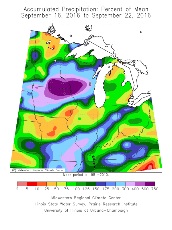
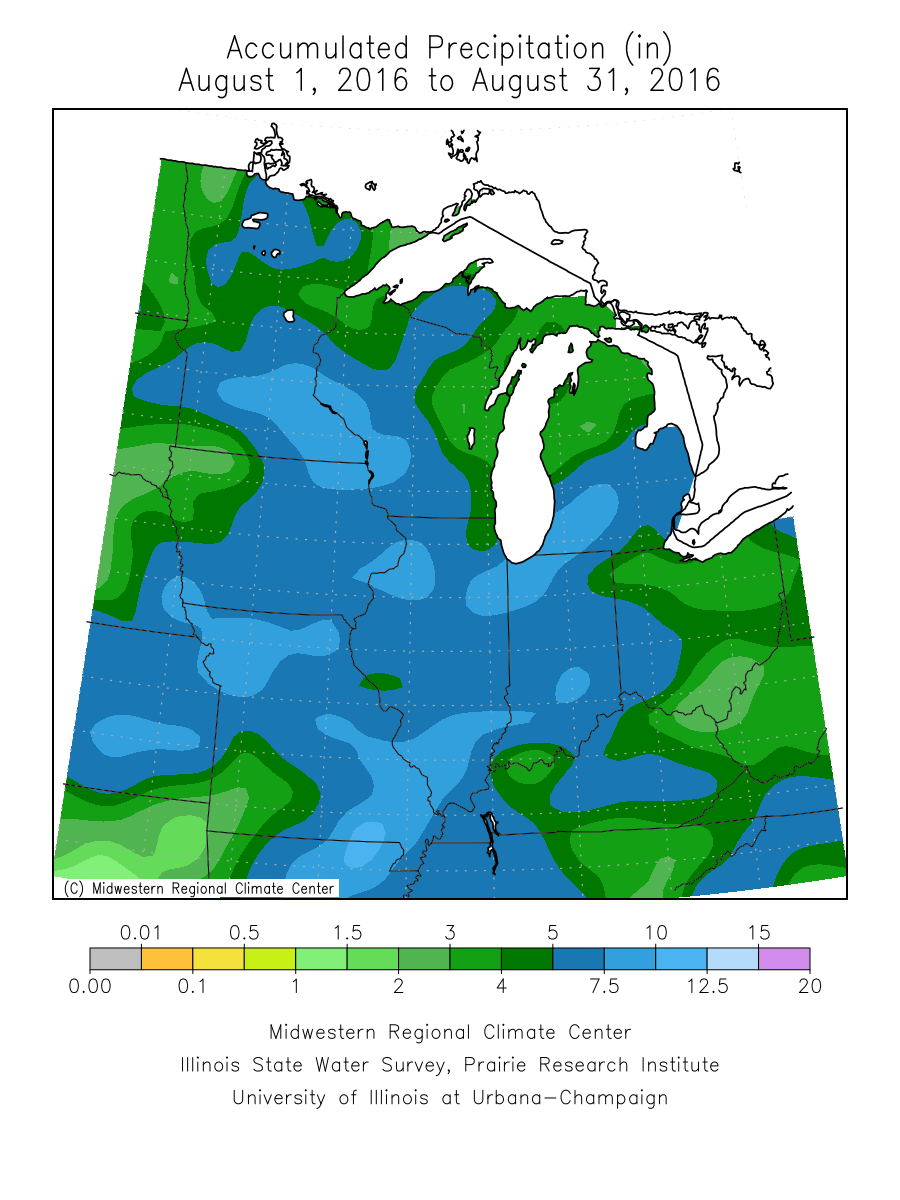
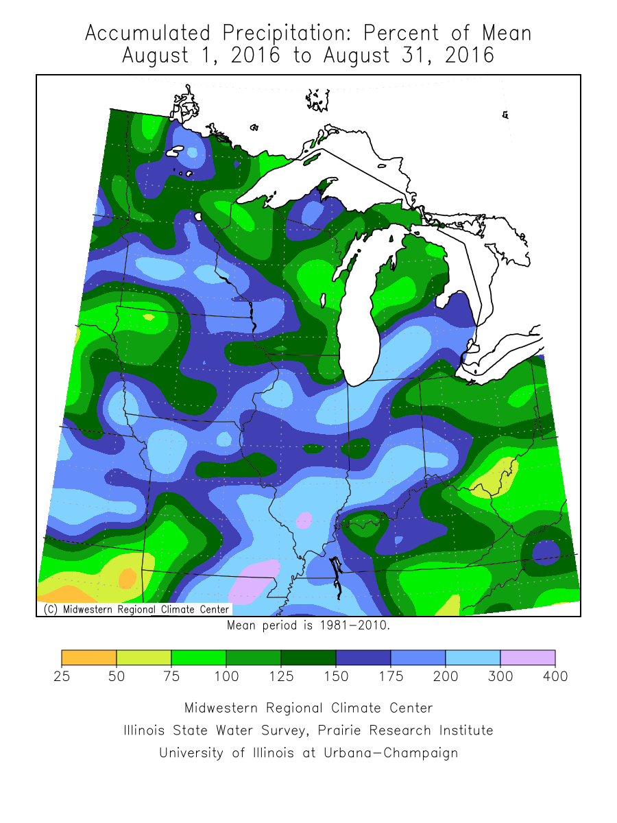
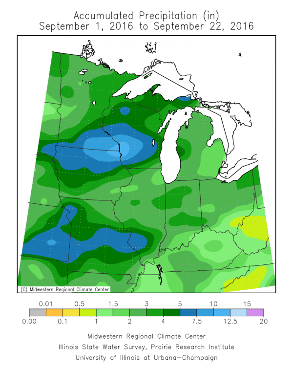
August and September (through the 22nd) precipitation totals and percent of normal. Note how wet August was, providing a good setup (wet grounds) for the flooding.
 |
 |
 |
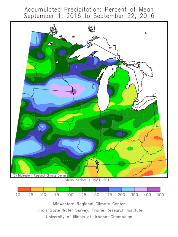 |
| August Precipitation | August Percent Of Normal | September - Through 22nd Precipitation | September - Percent of Normal Through 22nd |
Environment
Loop of the tropical air mass that moved over and stalled across the region. This air was more tropical, and held more moisture, than 97% of the air masses that affect this region normally in latter September.
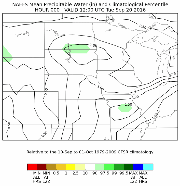 |
|||
| Precipitable Water |
 |
Media use of NWS Web News Stories is encouraged! Please acknowledge the NWS as the source of any news information accessed from this site. |
|


 Weather Story
 Weather Map
 Local Radar