Overview
|
Several rounds of showers and thunderstorms produced 2 to 4 inches of rain across mainly northeast Iowa into southwest Wisconsin on Friday, September 9th, 2016. Normally this might lead to relatively minor flooding, but combined with previous heavy rain, flooding began very quickly and area rivers went back into flood stage. In some cases rivers were still in flood from the heavy rains of September 6-7th, so this additional rain made matters worse. Numerous secondary roads in rural parts of northeast Iowa and southwest Wisconsin had water over them or were damaged. The Turkey and Upper Iowa Rivers in northeast Iowa quickly went into flood stage, while so did the Kickapoo River in southwest Wisconsin. |
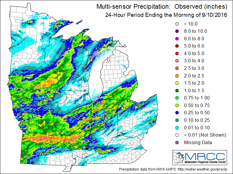 Rainfall total from September 9, 2016 |
Flooding
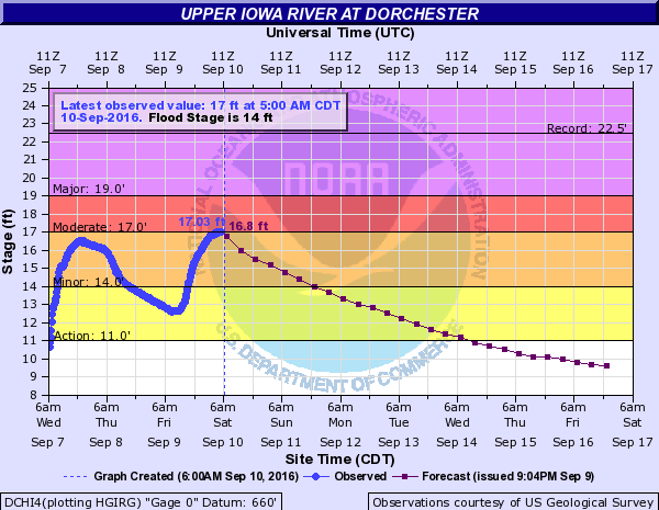
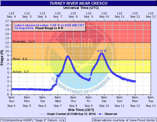
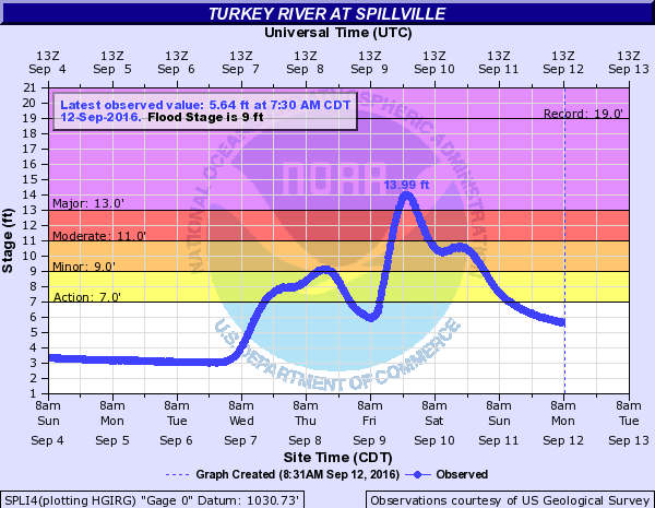
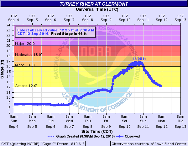
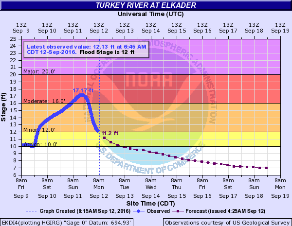
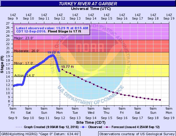
Hydrographs
 |
 |
 |
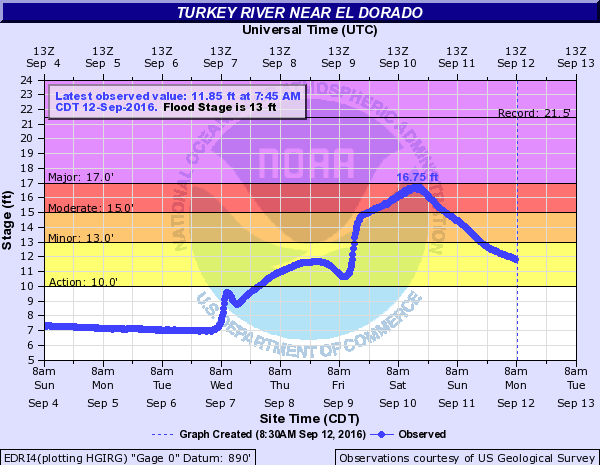 |
| Upper Iowa River at Dorchester, IA | Turkey River at Cresco, IA | Turkey River at Spillville, IA | Kickapoo River at Eldorado, IA |
 |
 |
 |
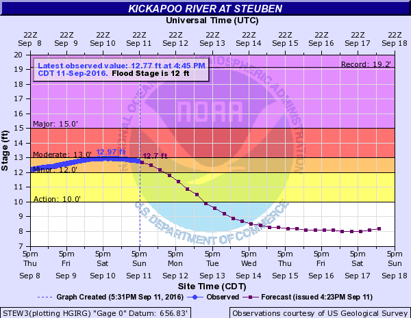 |
| Turkey River at Claremont, IA | Turkey River at Elkader, IA | Turkey River at Garber, IA | Kickapoo River at Steuben, WI |
Photos:
 |
 |
 |
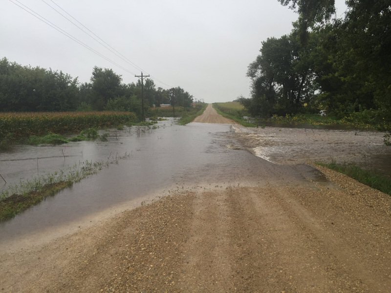 |
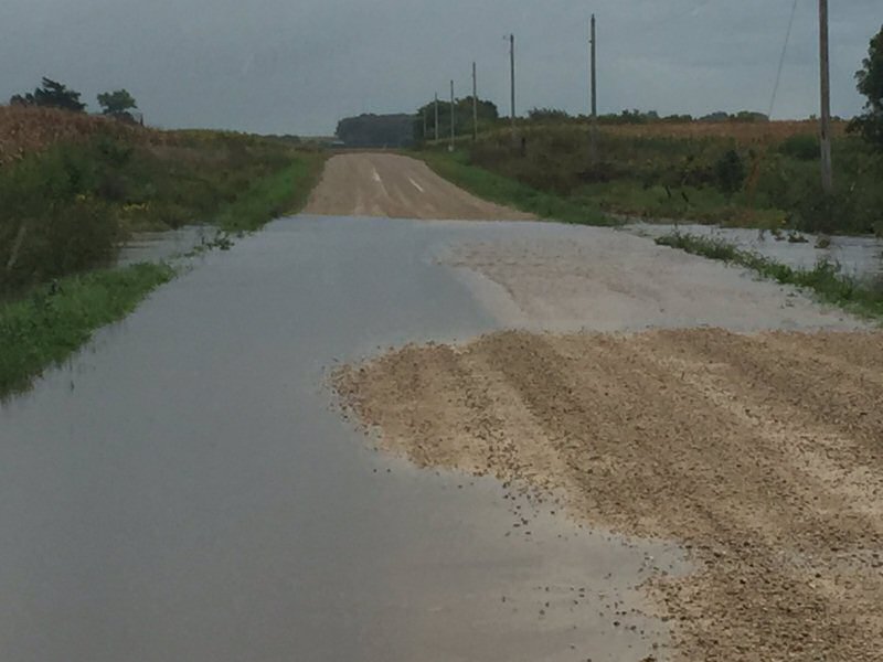
| Flooded roads in rural Chickasaw County, IA (Photo used with permission from Mike Donahue) |
Flooded roads in rural Chickasaw County, IA (Photo used with permission from Mike Donahue) |
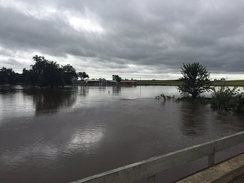
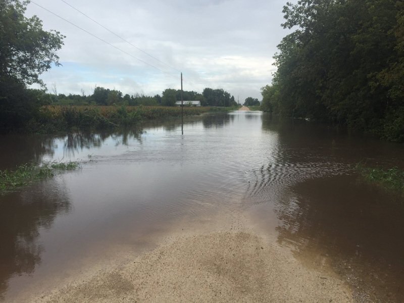
Flooding near New Hampton, IA (Photo used with permission from Mike Donahue) |
Flooding near New Hampton, IA (Photo used with permission from Mike Donahue) |
 |
 |
 |
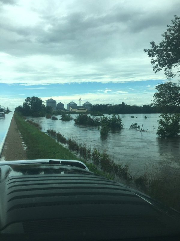 |
| Flooding near New Hampton, IA (Photo used with permission from Mike Donahue) |
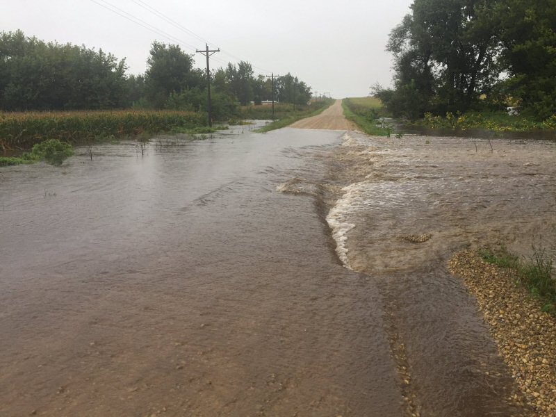
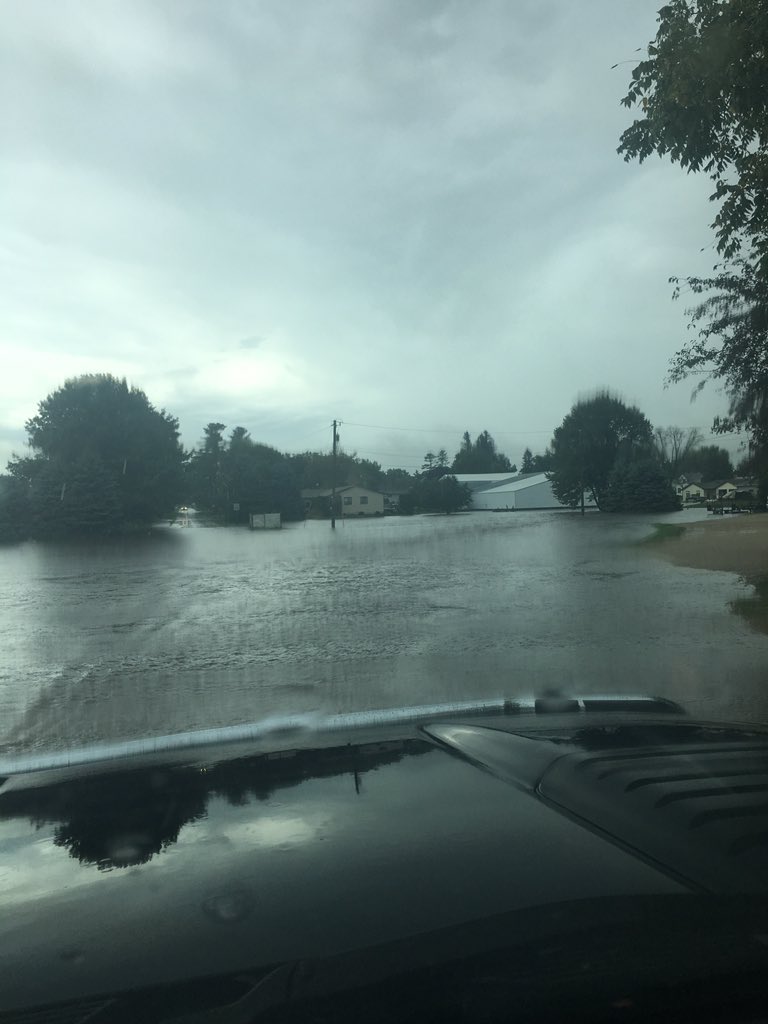
Flooded roads near Protivin, IA (Photo used by permission from Nate Acek) |
Flooded roads near Protivin, IA (Photo used by permission from Nate Acek) |
Flooded roads near Protivin, IA (Photo used by permission from Nate Acek) |
Rainfall Plot:
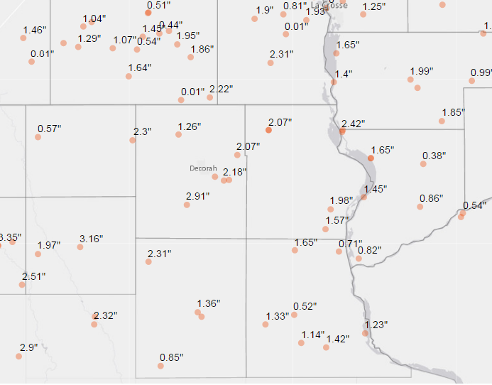 |
| Rainfall map |
Record Rainfall Report
RECORD EVENT REPORT
NATIONAL WEATHER SERVICE LA CROSSE WI
1124 AM CDT SAT SEP 10 2016

...RAINFALL RECORDS TIED OR BROKEN FOR SEPTEMBER 10TH...

THE FOLLOWING COOPERATIVE OBSERVERS EITHER BROKE OR TIED THE
RAINFALL RECORD FOR SEPTEMBER 10TH.

                        NEW         OLD              RECORDS
   LOCATION            RECORD      RECORD     YEAR    BEGAN
   --------            ------      ------     ----   -------
ALMA DAM WI         1.46 INCHES  1.33 INCHES  1986    1936
BLACK RIVER FALLS   1.03 INCHES  0.96 INCHES  1937    1948
CALMAR IA           2.91 INCHES  0.31 INCHES  2007    2006
CHARLES CITY IA     3.35 INCHES  1.98 INCHES  1918    1893
CRESCO 1NE IA       2.30 INCHES  1.60 INCHES  1896    1893
ELMA IA             2.07 INCHES  0.26 INCHES  2007    1907
GAYS MILLS WI       1.13 INCHES  0.50 INCHES  1986    1956
HARMONY MN          1.96 INCHES  0.94 INCHES  1964    1939
IONIA 2W IA         1.96 INCHES  0.35 INCHES  2007    2002
LA CRESCENT DAM 7   2.35 INCHES  2.22 INCHES  1964    1939
LA CROSSE WFO WI    2.07 INCHES  0.58 INCHES  2014    1996
LA CROSSE 4NNW WI   2.04 INCHES  0.78 INCHES  2014    1999
LA FARGE WI         1.15 INCHES  0.95 INCHES  1954    1940
LYNXVILLE DAM 9 WI  1.45 INCHES  1.40 INCHES  1970    1936
NASHUA 2SW IA       2.51 INCHES  0.19 INCHES  2014    2001
SPARTA WI           1.49 INCHES  1.42 INCHES  1938    1893
STEUBEN 4SE WI      1.00 INCHES  0.64 INCHES  1986    1971
STRAWBERRY POINT IA 1.07 INCHES  0.48 INCHES  2014    1948
WINONA DAM 5A MN    1.35 INCHES  1.09 INCHES  2014    1939
Rain Reports
Public Information Statement
National Weather Service La Crosse WI
950 AM CDT Sat Sep 10 2016

...Rainfall Reports...

Location                     Amount

...Iowa...

...Allamakee County...
Dorchester 3S                2.08 in
Waterville 3SE               1.98 in
Watson 4ENE                  1.57 in

...Chickasaw County...
New Hampton                  3.16 in
Ionia 2W                     2.13 in

...Clayton County...
Monona WWTP                  1.65 in
Volga 1NE                    1.33 in
Guttenberg Dam 10            1.23 in
Littleport                   1.14 in
Marquette-Bloody Run Creek   0.71 in
Elkader Turkey River         0.52 in

...Fayette County...
Alpha 1ENE                   2.31 in
Fayette                      1.36 in
Albany 3NW                   1.20 in
Oelwein Municipal Airport    0.85 in

...Floyd County...
Floyd 1NE                    3.85 in
Charles City                 3.35 in
Charles City Airport         2.71 in
Nashua 2sw                   2.51 in

...Howard County...
Elma 6E                      3.40 in
Cresco 1NE                   2.30 in
Elma                         2.07 in
3 NE Riceville               0.48 in

...Mitchell County...
Osage                        1.22 in
St Ansgar                    0.96 in

...Winneshiek County...
Calmar                       2.91 in
Bluffton 5ESE                2.90 in
Decorah 5NNW                 2.90 in
Decorah                      2.38 in
Decorah Municipal Airport    2.24 in
Decorah 5ESE                 2.18 in
Decorah 6ESE                 2.12 in
Decorah 7ENE                 2.07 in
Bluffton                     1.98 in

...Minnesota...

...Dodge County...
Claremont 2.5 SSE            1.57 in
Kasson 2NE                   1.06 in
Dodge Center Airport         0.49 in
Claremont 2E                 0.88 in

...Fillmore County...
Mabel                        2.22 in
Whalan 3.3 SSE               1.95 in
Highland 2SE                 1.86 in
Preston 6S                   1.77 in
Lanesboro 2NE                1.60 in
Preston 3NE                  1.45 in
Spring Valley 3E             1.29 in
Lanesboro-Root River         1.19 in
Preston                      1.19 in
Pilot Mound 1SSE             1.18 in
Spring Valley                1.13 in
Preston Airport              1.07 in
Fillmore 1W                  1.04 in
Pilot Mound-Root River       0.89 in
Fillmore                     0.86 in

...Houston County...
Caledonia                    2.31 in
La Crescent 1NNW             2.27 in
Hokah WWTP                   1.93 in
Houston                      1.79 in
Mound Prairie                1.56 in

...Mower County...
Grand Meadow                 1.46 in
Austin 3W - Turtle Creek     1.22 in
Ostrander 5WNW               1.09 in
Austin 2NE-Dobbins Creek     0.96 in
Austin                       0.92 in
Austin 3S                    0.86 in

...Olmsted County...
Rochester 3NNE               2.60 in
Eyota 2NE                    1.42 in
Rock Dell 2N                 1.41 in
Byron                        1.30 in
Rochester 2NE                1.22 in
Rochester                    1.22 in
Rochester-Cascade Creek      1.18 in
Rochester-Beltline           1.13 in
Rochester-Bear Creek         1.08 in
Chester 2NNW                 0.99 in
Elba 4.7 SW                  0.98 in
Oronoco 1W                   0.95 in
Rochester 3W                 0.87 in
Pine Island 1S               0.87 in
Rochester Intl Airport       0.86 in
Byron 4N                     0.80 in

...Wabasha County...
Wabasha                      1.52 in
Plainview                    1.48 in
Zumbro Falls 2NNW            1.23 in
Kellogg-Zumbro River         1.16 in
Zumbro Falls 3SW             1.13 in
Theilman 1SSW                0.89 in
Mazeppa 3ESE                 0.72 in
Lake City                    0.71 in

...Winona County...
La Crescent Dam 7            2.35 in
Stockton                     1.57 in
Winona Dam 5A                1.35 in
Whitewater State Park        1.15 in
Pickwick 2NNW                1.10 in
Winona 1E                    0.93 in
Minnesota City Dam 5         0.92 in
Stockton 3ESE                0.89 in
Altura 5W                    0.82 in
Lewiston                     0.74 in

...Wisconsin...

...Adams County...
Petenwell Lake               0.92 in
Friendship                   0.82 in
Castle Rock                  0.77 in
New Rome 2SE                 0.73 in

...Buffalo County...
Alma Dam 4                   1.46 in

...Clark County...
Neillsville 1W               1.11 in
Colby 6SW                    0.75 in
Owen 2N                      0.55 in

...Crawford County...
De Soto 1SE                  2.42 in
Ferryville 1SE               1.65 in
Mount Sterling               1.49 in
Lynxville Dam 9              1.45 in
Eastman                      1.21 in
Gays Mills                   1.13 in
Mount Zion 1WNW              1.05 in
Steuben                      0.86 in
Prairie Du Chien Airport     0.82 in

...Grant County...
Boscobel 1ENE                0.59 in
Boscobel Airport             0.54 in
Muscoda                      0.52 in
Platteville Municipal Airpor 0.08 in

...Jackson County...
Black River Falls-black Rive 1.41 in
Hatfield Dam                 1.25 in
Black River Falls Area Airpo 1.15 in
Black River Falls Sewage     1.03 in
Black River Falls 1E         0.99 in

...Juneau County...
Volk Field                   1.99 in
Mauston                      1.08 in
Cloverdale 2N                0.99 in
Necedah                      0.92 in
Dellwood 2WNW                0.71 in
Wisconsin Dells 2WNW         0.69 in

...La Crosse County...
La Crosse Weather Office     2.07 in
La Crosse 4NNW               2.04 in
West Salem                   2.00 in
West Salem 0.7 W             2.00 in
La Crosse Regional Airport   1.91 in
Holmen 2S                    1.82 in
Saint Joseph 3W              1.10 in

...Monroe County...
Melvina                      1.80 in
Sparta                       1.49 in
Cataract                     1.41 in
Sparta/Fort McCoy Airport    1.34 in
Fort Mccoy- Stillwell Creek  1.25 in
4 W Valley Junction          1.18 in
Warrens 4WSW                 1.15 in
Four Corners                 1.08 in
Kendall 1N                   0.98 in
Kendall                      0.90 in

...Richland County...
Richland Center 4N           1.57 in
3 NW Avoca                   0.93 in

...Taylor County...
Medford Airport              1.18 in
Gad                          0.93 in
Medford                      0.81 in
Chelsea                      0.78 in
Lublin 3NE                   0.62 in
Jump River 1NW               0.31 in

...Trempealeau County...
Trempealeau Dam 6            1.47 in
Ettrick 4WNW                 0.62 in
Dodge                        0.06 in

...Vernon County...
Viroqua Municipal Airport    1.99 in
Readstown                    1.85 in
Viroqua                      1.75 in
Stoddard                     1.65 in
Ontario                      1.60 in
Viroqua 0.8 ESE              1.57 in
Genoa Dam 8                  1.40 in
Hillsboro 2sw                1.20 in
La Farge                     0.99 in

Observations are collected from a variety of sources with varying
equipment and exposures. Not all data listed are considered official.
 |
Media use of NWS Web News Stories is encouraged! Please acknowledge the NWS as the source of any news information accessed from this site. |
|


 Weather Story
 Weather Map
 Local Radar