Overview
|
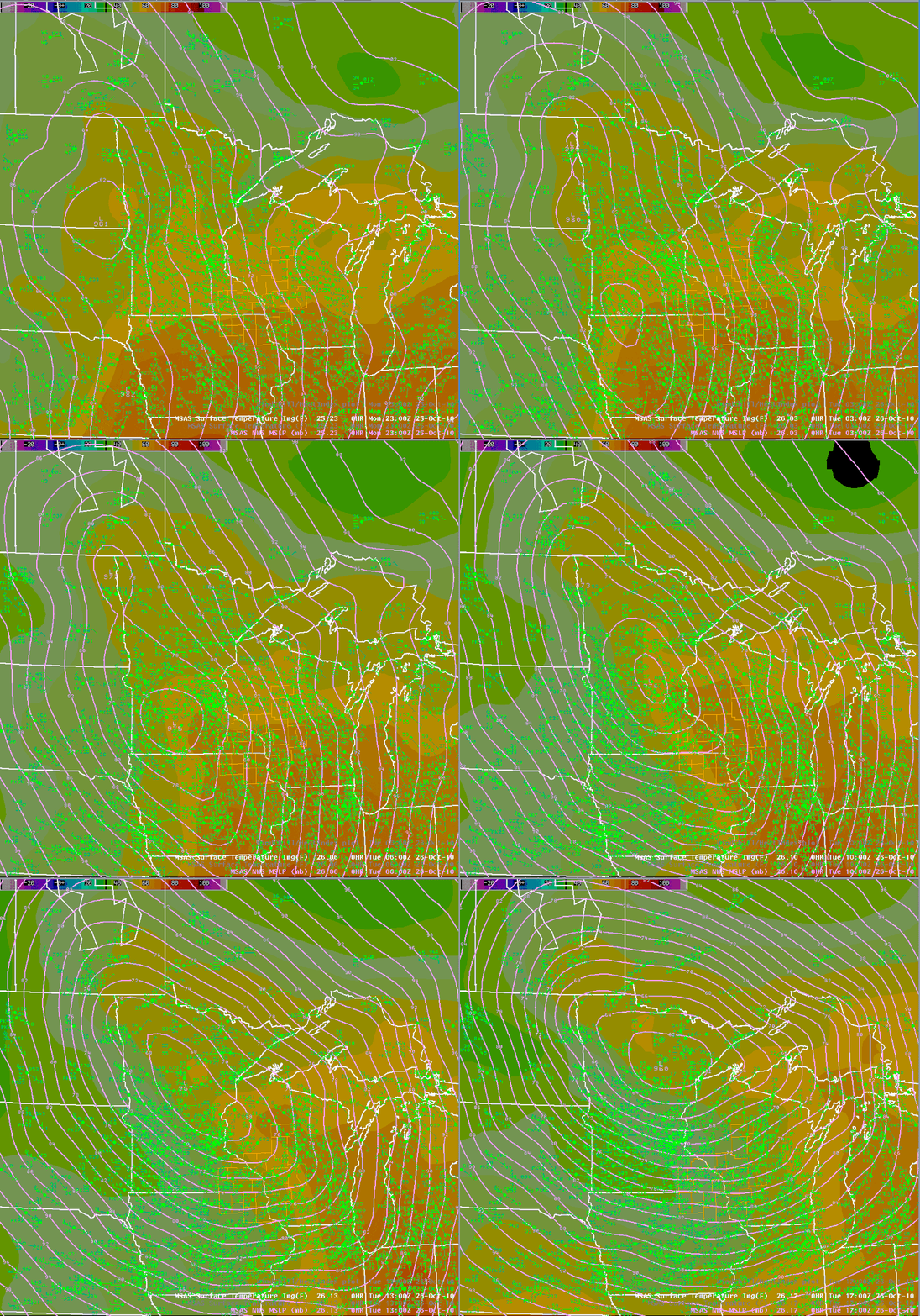
An area of low pressure moved out of the Southern Plains and rapidly deepened into Minnesota during the early morning hours of October 26th. As it moved north, shower and thunderstorm activity provided rainfall amounts of one-half to just over one inch in some locations. More importantly though,the central pressure of the low continued to fall causing an increase in winds as the day progressed. By late in the morning of October 26th, sustained wind speeds of 25 to 35 mph, with gusts of 40 to 50 mph, were reported over parts of western Minnesota. By early afternoon, wind gusts of 50 to 55 mph were common across southeast Minnesota, northeast Iowa, and into western Wisconsin causing sporadic wind damage to roofs and trees. The winds continued during the evening and overnight hours, with reported gusts near 60 mph around 2 a.m. at many locations (including 61 mph at Spring Valley, MN). The low pressure system's central pressure slowly began to increase (or weaken) early in the morning on the 27th as it started to move into southern Canada. However the pressure gradient, or the difference between the central low pressure and the pressure surrounding the storm, did not weaken much. Therefore, the winds did not weaken and some locations experienced their strongest wind gusts from this wind event during the early morning hours. The stronger pressure gradient is indicated by the tight "packing" of the isobars (lines of constant pressure) seen in the loops below. By the evening of the 27th, winds diminished with gusts falling below 45 mph, due to the system continuing to weaken and moving farther away from the region. While this storm set records for the lowest pressure ever recorded in Minnesota (Bigfork, MN - 955.2 mb / 28.21" - 5:13 p.m. October 26, 2010) and Wisconsin (Superior, WI - 961.3 mb / 28.39" - 11:15 a.m. October 26, 2010), it did not have the higher end winds seen in the November 10 1998 storm. The 1998 storm, which held the previous records for lowest pressure, produced sporadic 60-80 mph winds. One of the contributing factors for the higher wind gusts in 1998 was the greater difference in the pressure from outside the storm to the center - or a stronger pressure gradient. This pressure difference is the force that accelerates the air into the low pressure center. As an example, the 1998 storm had a pressure difference from Kansas City, Missouri (outside the storm) to Duluth, Minnesota (center of the storm) of around 40 millibars. For this storm, that measured difference from Kansas City to Duluth was around 30 millibars (about 25% less). A High Wind Watch was issued by the National Weather Service in La Crosse on Sunday afternoon, October 24th. The following day, the watch was replaced with High Wind Warnings (issued at 3:27 p.m. CDT October 25th) that covered Tuesday and Wednesday. A webinar was also held with Emergency Management partners to assist with planning. Other links about this storm include: |
 Track of the low pressure area that produced record low pressure levels and extreme winds. |
Peak Wind Gusts:
| Location | Wind Gust | Time / Date | Source |
| Stacyville, IA 3E | 88 mph | Oct.27 | Wind Turbine (262 ft) |
| Mt.Sterling, WI | 70 mph | 518 p.m. Oct.27 | Amateur Radio |
| La Crosse, WI 4SE | 69 mph | 820 p.m. Oct.26 | Public |
| Prairie du Chien, WI 10NNE | 64 mph | 220 p.m. Oct.26 | Law Enforcement |
| Spring Valley, MN 3E | 64 mph | 1014 a.m. Oct.27 | Public/COOP |
| Eyota, MN 2SE | 63 mph | 421 a.m. Oct.27 | Road Weather |
| Union, WI 2S | 63 mph | 220 p.m. Oct.27 | Public |
| Necedah, WI 1WNW | 62 mph | 1248 p.m. Oct.27 | Fire Weather |
| Arcadia, WI 2S | 61 mph | 607 a.m. Oct.27 | Road Weather |
| Spencer, WI 2SW | 60 mph | 745 a.m. Oct.27 | Public |
| Harpers Ferry, IA | 60 mph | 1031 a.m. Oct.27 | Amateur Radio |
| La Crosse, WI AP | 59 mph | 117 a.m. Oct.27 | ASOS |
| Canton, MN 2ESE | 58 mph | 1119 a.m. Oct.27 | Road Weather |
| La Crosse, WI 4S | 58 mph | 225 a.m. Oct.27 | Amateur Radio / Spotter |
| Platteville, WI | 58 mph | 1255 p.m. Oct.27 | AWOS |
| Rochester, MN AP | 58 mph | 119 a.m. Oct.27 | ASOS |
| Viroqua, WI | 58 mph | 215 a.m. Oct.27 | AWOS |
| Dodge Center, MN | 56 mph | 655 a.m. Oct.27 | AWOS |
| Volk Field, WI | 56 mph | 255 a.m. Oct.27 | ASOS |
| Ionia, IA 2N | 55 mph | 926 a.m. Oct.27 | Road Weather |
| Platteville, WI 1W | 55 mph | 1240 p.m. Oct.27 | Public |
| Boscobel, WI 1ENE | 54 mph | 1103 a.m. Oct.27 | Fire Weather |
| Charles City, IA | 54 mph | 1135 a.m. Oct.27 | AWOS |
| La Crosse NWS | 54 mph | Oct.27 | Weather Station |
| Medford, WI | 54 mph | 1155 p.m. Oct.26 | AWOS |
| Winona, MN | 54 mph | 736 a.m. Oct.27 | Emerg. Management |
| Kellogg, MN 2SSE | 53 mph | 644 a.m. Oct.27 | Road Weather |
| Decorah, IA 5SE | 52 mph | 1037 a.m. Oct.27 | Road Weather |
| Lone Rock, WI | 52 mph | 1025 a.m. Oct.27 | ASOS |
| Mauston, WI 1E | 51 mph | 608 a.m. Oct.27 | Road Weather |
| Neillsville, WI | 50 mph | 318 a.m. Oct.27 | Public |
| Boscobel, WI | 49 mph | 139 p.m. Oct.27 | ASOS |
| Mt.Sterling, WI 1SW | 49 mph | 1105 a.m. Oct.27 | Road Weather |
| Preston, MN | 49 mph | 1036 a.m. Oct.27 | AWOS |
| Winona, MN 4SW | 49 mph | 1100 a.m. Oct.27 | Public |
| Prairie du Chien, WI | 48 mph | 115 p.m. Oct.27 | AWOS |
| Austin, MN | 47 mph | 155 p.m. Oct.27 | AWOS |
| Decorah, IA | 45 mph | 1055 a.m. Oct.27 | AWOS |
| Richland Center, WI | 44 mph | 1053 a.m. Oct.27 | Amateur Radio |
| Sparta, WI | 41 mph | 1138 a.m. Oct.27 | AWOS |
| Winona, MN | 41 mph | 954 p.m. Oct.26 | AWOS |
Storm Reports
PRELIMINARY LOCAL STORM REPORT...SUMMARY
NATIONAL WEATHER SERVICE LA CROSSE WI
721 PM CDT WED OCT 27 2010
..TIME... ...EVENT... ...CITY LOCATION... ...LAT.LON...
..DATE... ....MAG.... ..COUNTY LOCATION..ST.. ...SOURCE....
..REMARKS..
0530 AM NON-TSTM WND GST WAUKON 43.27N 91.48W
10/26/2010 M46.00 MPH ALLAMAKEE IA EMERGENCY MNGR
0545 AM NON-TSTM WND GST UNION 42.83N 90.52W
10/26/2010 M50.00 MPH GRANT WI PUBLIC
0555 AM NON-TSTM WND GST 4 SE PLATTEVILLE 42.69N 90.42W
10/26/2010 M48.00 MPH LAFAYETTE WI AWOS
PLATTEVILLE AWOS MEASURED 48 MILES PER HOUR WIND GUST
0555 AM NON-TSTM WND GST PLATTEVILLE 42.74N 90.48W
10/26/2010 M48.00 MPH GRANT WI AWOS
0635 AM NON-TSTM WND DMG ELLENBORO 42.78N 90.62W
10/26/2010 GRANT WI EMERGENCY MNGR
TREE FELL ON PASSING CAR NEAR INTERSECTION OF COUNTY
ROADS D AND E
0714 AM NON-TSTM WND GST WAUKON 43.27N 91.48W
10/26/2010 M43.00 MPH ALLAMAKEE IA EMERGENCY MNGR
0730 AM NON-TSTM WND GST MAUSTON 43.80N 90.08W
10/26/2010 M52.00 MPH JUNEAU WI BROADCAST MEDIA
MAUSTON WRJC RADIO MEASURED WIND GUST OF 52 MILES PER
HOUR
0801 AM NON-TSTM WND DMG CASTLE ROCK 43.05N 90.53W
10/26/2010 GRANT WI EMERGENCY MNGR
TREES DOWN ON WITEK ROAD
0929 AM NON-TSTM WND GST 3 SW BARRE MILLS 43.80N 91.16W
10/26/2010 E46.00 MPH LA CROSSE WI PUBLIC
1028 AM NON-TSTM WND GST 2 SW ROCHESTER 43.99N 92.50W
10/26/2010 M46.00 MPH OLMSTED MN ASOS
1030 AM NON-TSTM WND DMG GREENWOOD 44.77N 90.60W
10/26/2010 CLARK WI EMERGENCY MNGR
ROOF BLOWN OFF 40X80 FOOT SHED ALONG HIGHWAY 73. TREE
ALSO BLOWN DOWN.
1035 AM NON-TSTM WND GST 3 SE PLATTEVILLE 42.70N 90.44W
10/26/2010 M49.00 MPH GRANT WI AWOS
1044 AM NON-TSTM WND GST 2 ESE CANTON 43.52N 91.89W
10/26/2010 M46.00 MPH FILLMORE MN MESONET
1049 AM NON-TSTM WND GST 2 SE EYOTA 43.97N 92.20W
10/26/2010 M46.00 MPH OLMSTED MN MESONET
1055 AM NON-TSTM WND GST 2 NW VIROQUA 43.58N 90.91W
10/26/2010 M47.00 MPH VERNON WI AWOS
1055 AM NON-TSTM WND GST 2 S PRAIRIE DU CHIEN 43.01N 91.14W
10/26/2010 M46.00 MPH CRAWFORD WI AWOS
1109 AM NON-TSTM WND GST WAUKON 43.27N 91.48W
10/26/2010 M51.00 MPH ALLAMAKEE IA EMERGENCY MNGR
ALLAMAKEE COUNTY COURT HOUSE
1109 AM NON-TSTM WND GST WAUKON 43.27N 91.48W
10/26/2010 M51.00 MPH ALLAMAKEE IA EMERGENCY MNGR
1135 AM NON-TSTM WND GST 2 N IONIA 43.07N 92.46W
10/26/2010 M49.00 MPH CHICKASAW IA MESONET
1135 AM NON-TSTM WND GST 3 E CHARLES CITY 43.07N 92.62W
10/26/2010 M45.00 MPH FLOYD IA AWOS
1143 AM NON-TSTM WND GST 3 E LA CROSSE 43.83N 91.17W
10/26/2010 M50.00 MPH LA CROSSE WI NWS EMPLOYEE
MEASURED AT NWS LA CROSSE OFFICE
1145 AM NON-TSTM WND GST 3 E SPRING VALLEY 43.69N 92.33W
10/26/2010 M47.00 MPH FILLMORE MN CO-OP OBSERVER
1153 AM NON-TSTM WND GST 2 E BOSCOBEL 43.14N 90.66W
10/26/2010 M46.00 MPH GRANT WI AWOS
1155 AM NON-TSTM WND GST 2 E AUSTIN 43.67N 92.93W
10/26/2010 M46.00 MPH MOWER MN AWOS
0210 PM NON-TSTM WND DMG PLATTEVILLE 42.74N 90.48W
10/26/2010 GRANT WI EMERGENCY MNGR
LARGE TREE BLOWN DOWN ONTO CARS
0220 PM NON-TSTM WND GST 10 NNE PRAIRIE DU CHIEN 43.18N 91.06W
10/26/2010 M64.00 MPH CRAWFORD WI LAW ENFORCEMENT
0637 PM NON-TSTM WND GST 3 E SPRING VALLEY 43.69N 92.33W
10/26/2010 M49.00 MPH FILLMORE MN CO-OP OBSERVER
0759 PM NON-TSTM WND GST 3 E SPRING VALLEY 43.69N 92.33W
10/26/2010 M55.00 MPH FILLMORE MN CO-OP OBSERVER
0759 PM NON-TSTM WND GST 3 N STEWARTVILLE 43.90N 92.49W
10/26/2010 M55.00 MPH OLMSTED MN ASOS
PEAK WIND GUST FROM ROCHESTER MN AIRPORT ASOS
0806 PM NON-TSTM WND GST 2 SE EYOTA 43.97N 92.20W
10/26/2010 M58.00 MPH OLMSTED MN MESONET
0814 PM NON-TSTM WND DMG COLBY 44.91N 90.32W
10/26/2010 CLARK WI EMERGENCY MNGR
TREE DOWN ON POWER LINE CAUSED POWER OUTAGES AT COLBY AND
UNITY
0900 PM NON-TSTM WND GST 2 NW WABASHA 44.39N 92.07W
10/26/2010 M47.00 MPH WABASHA MN AMATEUR RADIO
0930 PM NON-TSTM WND DMG 3 E TAYLOR 44.32N 91.06W
10/26/2010 JACKSON WI CO-OP OBSERVER
TREES DOWNED CAUSED A POWER OUTAGE FROM 930 PM TO
MIDNIGHT ON OCTOBER 26TH
0945 PM NON-TSTM WND GST 7 E LOYAL 44.74N 90.35W
10/26/2010 E60.00 MPH CLARK WI PUBLIC
LOW PRESSURE READING 28.89 INCHES
1100 PM TSTM WND DMG BLACK RIVER FALLS 44.30N 90.85W
10/26/2010 JACKSON WI LAW ENFORCEMENT
POWER LINES AND TREES DOWN NEAR BLACK RIVER FALLS
1100 PM TSTM WND DMG MELROSE 44.13N 91.00W
10/26/2010 JACKSON WI LAW ENFORCEMENT
POWER LINES DOWN NEAR MELROSE
1100 PM NON-TSTM WND DMG WHITEHALL 44.37N 91.31W
10/26/2010 TREMPEALEAU WI LAW ENFORCEMENT
TREES DOWN ACROSS PARTS OF COUNTY. WORST DAMAGE BETWEEN
WHITEHALL AND STRUM THAT SEEMS TO HAVE OCCURRED BETWEEN
11 PM AND 1 AM. TREES BLOCKED ROADS IN SOME CASES.
1141 PM NON-TSTM WND DMG WAUMANDEE 44.30N 91.70W
10/26/2010 BUFFALO WI LAW ENFORCEMENT
REPORT OF TREE DOWN WITHIN THE LAST HOUR
1141 PM NON-TSTM WND DMG MONDOVI 44.57N 91.67W
10/26/2010 BUFFALO WI LAW ENFORCEMENT
REPORT OF TREE DOWN WITHIN THE LAST HOUR
1141 PM NON-TSTM WND DMG VIROQUA 43.56N 90.89W
10/26/2010 VERNON WI LAW ENFORCEMENT
SPORADIC TREES DOWN ACROSS VERNON COUNTY
1200 AM NON-TSTM WND DMG STRUM 44.55N 91.39W
10/27/2010 TREMPEALEAU WI LAW ENFORCEMENT
TREE FELL ON VEHICLE AND POWER LINES DOWN.
1215 AM NON-TSTM WND GST 3 E SPRING VALLEY 43.69N 92.33W
10/27/2010 M61.00 MPH FILLMORE MN TRAINED SPOTTER
0115 AM NON-TSTM WND DMG 3 S ROCHESTER 43.97N 92.48W
10/27/2010 OLMSTED MN CO-OP OBSERVER
PINE TREE FELL ON POWER LINES OVERNIGHT
0135 AM NON-TSTM WND GST DODGE CENTER 44.03N 92.85W
10/27/2010 M53.00 MPH DODGE MN AWOS
0153 AM NON-TSTM WND GST 4 NNW LA CROSSE 43.88N 91.26W
10/27/2010 M59.00 MPH LA CROSSE WI ASOS
0154 AM NON-TSTM WND GST ROCHESTER 44.01N 92.48W
10/27/2010 M58.00 MPH OLMSTED MN ASOS
0211 AM NON-TSTM WND GST 1 E LA CROSSE 43.83N 91.21W
10/27/2010 M53.00 MPH LA CROSSE WI OFFICIAL NWS OBS
NWS OFFICE
0215 AM NON-TSTM WND GST VIROQUA 43.56N 90.89W
10/27/2010 M58.00 MPH VERNON WI AWOS
0300 AM NON-TSTM WND GST 2 NW WABASHA 44.39N 92.07W
10/27/2010 M49.00 MPH WABASHA MN AMATEUR RADIO
0300 AM NON-TSTM WND DMG VIROQUA 43.56N 90.89W
10/27/2010 VERNON WI LAW ENFORCEMENT
SEVERAL TREES DOWN ACROSS COUNTY. LARGE TREE FELL ON
POWER LINE IN LA FARGE AT 3 AM. WORSE DAMAGE WAS
OVERNIGHT.
0318 AM NON-TSTM WND GST NEILLSVILLE 44.56N 90.59W
10/27/2010 M50.00 MPH CLARK WI PUBLIC
0356 AM NON-TSTM WND GST 5 W PRESTON 43.67N 92.18W
10/27/2010 M46.00 MPH FILLMORE MN AWOS
0400 AM NON-TSTM WND GST 4 SW WINONA 44.01N 91.71W
10/27/2010 M46.00 MPH WINONA MN MESONET
0435 AM NON-TSTM WND DMG MEDFORD 45.14N 90.35W
10/27/2010 TAYLOR WI LAW ENFORCEMENT
ROOF BLOWN OFF BUSINESS ON MAIN STREET ALONG WITH
NUMEROUS TREES DOWN. SPOTTY POWER OUTAGES REPORTED IN
MEDFORD AND RIB LAKE. TIME APPROXIMATED SINCE THERE WERE
SEVERAL HIGH WIND GUSTS OVERNIGHT.
0455 AM NON-TSTM WND GST MEDFORD 45.14N 90.35W
10/27/2010 M51.00 MPH TAYLOR WI AWOS
0530 AM NON-TSTM WND DMG RIB LAKE 45.32N 90.20W
10/27/2010 TAYLOR WI EMERGENCY MNGR
POWER OUTAGES REPORTED OVERNIGHT
0655 AM NON-TSTM WND GST DODGE CENTER 44.03N 92.85W
10/27/2010 M56.00 MPH DODGE MN AWOS
0700 AM NON-TSTM WND DMG LA CROSSE 43.83N 91.23W
10/27/2010 LA CROSSE WI EMERGENCY MNGR
30 REPORTS OF TREES DOWN AND TRAFFIC SIGNS DAMAGED. POWER
LINES BLOWN DOWN AS WELL WITH SOME CANCELLED FLIGHTS
OVERNIGHT AT AIRPORT.
0700 AM NON-TSTM WND DMG ROCHESTER 44.01N 92.48W
10/27/2010 OLMSTED MN EMERGENCY MNGR
SPORADIC POWER OUTAGES AND POSSIBLE ROOF DAMAGE TO
APARTMENT BUILDING.
0700 AM NON-TSTM WND DMG AUSTIN 43.67N 92.97W
10/27/2010 MOWER MN LAW ENFORCEMENT
TREES AND POWER LINES DOWN.
0700 AM NON-TSTM WND DMG MANTORVILLE 44.07N 92.75W
10/27/2010 DODGE MN LAW ENFORCEMENT
TREES DOWN IN VARIOUS PARTS OF COUNTY AND SHEET METAL
FENCING BLOWN OFF AT FAIRGROUNDS.
0709 AM NON-TSTM WND GST 2 NE ROCHESTER 44.03N 92.45W
10/27/2010 E43.00 MPH OLMSTED MN TRAINED SPOTTER
0715 AM NON-TSTM WND DMG SPARTA 43.94N 90.81W
10/27/2010 MONROE WI LAW ENFORCEMENT
FEW TREES DOWN ACROSS COUNTY...SOME BLOCKING SINGLE
LANES.
0715 AM NON-TSTM WND DMG MAUSTON 43.80N 90.08W
10/27/2010 JUNEAU WI LAW ENFORCEMENT
SEVERAL TREES DOWN ACROSS COUNTY. FEW POWER LINES AND
POLES DOWN ALONG WITH DAMAGED CAUSED BY FALLING TREES.
0715 AM NON-TSTM WND DMG CALEDONIA 43.63N 91.50W
10/27/2010 HOUSTON MN LAW ENFORCEMENT
TREE DOWN ON SHED AND HORSE TRAILER
0730 AM NON-TSTM WND DMG ADAMS 43.96N 89.82W
10/27/2010 ADAMS WI LAW ENFORCEMENT
SEVERAL TREES DOWN WITH SPORADIC FIRES FROM TREES FALLING
ON POWER LINES. A FEW VEHICLE COLLISIONS WITH DOWNED
TREES ON ROADS.
0730 AM NON-TSTM WND DMG ALMA 44.33N 91.92W
10/27/2010 BUFFALO WI LAW ENFORCEMENT
FEW TREES DOWN ACROSS COUNTY.
0736 AM NON-TSTM WND GST WINONA 44.05N 91.66W
10/27/2010 M54.00 MPH WINONA MN EMERGENCY MNGR
0745 AM NON-TSTM WND GST 7 E LOYAL 44.74N 90.35W
10/27/2010 E60.00 MPH CLARK WI PUBLIC
0745 AM NON-TSTM WND DMG RICHLAND CENTER 43.34N 90.38W
10/27/2010 RICHLAND WI LAW ENFORCEMENT
A FEW SMALL TREES DOWN
0745 AM NON-TSTM WND DMG LANCASTER 42.85N 90.71W
10/27/2010 GRANT WI LAW ENFORCEMENT
TREES DOWN ACROSS THE COUNTY
0800 AM NON-TSTM WND DMG BLACK RIVER FALLS 44.30N 90.85W
10/27/2010 JACKSON WI LAW ENFORCEMENT
SEVERAL TREES AND POWER LINES DOWN ACROSS COUNTY. POWER
OUTAGES REPORTED IN TOWN.
0815 AM NON-TSTM WND GST DODGE CENTER 44.03N 92.85W
10/27/2010 M51.00 MPH DODGE MN AWOS
0820 AM NON-TSTM WND DMG 6 S ZUMBRO FALLS 44.20N 92.43W
10/27/2010 WABASHA MN BROADCAST MEDIA
SEMI TRUCK BLOWN OVER ALONG HIGHWAY 63 NEAR COUNTY LINE.
0900 AM NON-TSTM WND DMG NEILLSVILLE 44.56N 90.59W
10/27/2010 CLARK WI LAW ENFORCEMENT
WIDESPREAD TREES AND POWER LINES DOWN ACROSS THE COUNTY.
STRONGEST WINDS STARTED AROUND 8 PM LAST NIGHT AND
CONTINUE THIS MORNING.
0911 AM NON-TSTM WND DMG PRESTON 43.67N 92.08W
10/27/2010 FILLMORE MN LAW ENFORCEMENT
MINOR TREES DOWN
0945 AM NON-TSTM WND DMG ST. CHARLES 43.97N 92.06W
10/27/2010 WINONA MN EMERGENCY MNGR
LARGE COTTONWOOD TREES DOWN IN CITY PARK. TREE DOWN ALONG
HIGHWAY 74 AS WELL.
1014 AM NON-TSTM WND GST 3 E SPRING VALLEY 43.69N 92.33W
10/27/2010 M64.00 MPH FILLMORE MN CO-OP OBSERVER
MIXED WITH SNOW PELLETS
1015 AM NON-TSTM WND GST 4 E CHARLES CITY 43.07N 92.60W
10/27/2010 M45.00 MPH FLOYD IA AWOS
1018 AM NON-TSTM WND GST 4 N LA CROSSE 43.88N 91.23W
10/27/2010 M52.00 MPH LA CROSSE WI ASOS
1020 AM NON-TSTM WND GST VOLK FIELD 43.93N 90.27W
10/27/2010 M47.00 MPH JUNEAU WI ASOS
1025 AM NON-TSTM WND GST LONE ROCK 43.18N 90.20W
10/27/2010 M52.00 MPH RICHLAND WI ASOS
1030 AM NON-TSTM WND GST 4 SSE ROCHESTER 43.96N 92.44W
10/27/2010 M45.00 MPH OLMSTED MN ASOS
1030 AM NON-TSTM WND DMG 2 W ARKDALE 44.03N 89.92W
10/27/2010 ADAMS WI NWS EMPLOYEE
SEVERAL TREES DOWN NEAR HIGHWAY 21
1030 AM NON-TSTM WND DMG 4 N DELLWOOD 44.03N 89.96W
10/27/2010 ADAMS WI NWS EMPLOYEE
4-5 TREES DOWN ALONG COUNTY ROAD Z
1035 AM NON-TSTM WND GST 3 E CHARLES CITY 43.07N 92.62W
10/27/2010 M51.00 MPH FLOYD IA AWOS
1047 AM NON-TSTM WND GST 4 SSW ROCHESTER 43.96N 92.51W
10/27/2010 M49.00 MPH OLMSTED MN ASOS
1053 AM NON-TSTM WND GST RICHLAND CENTER 43.34N 90.38W
10/27/2010 M44.00 MPH RICHLAND WI AMATEUR RADIO
TREES DOWN IN TOWN
1053 AM NON-TSTM WND GST BOSCOBEL 43.14N 90.70W
10/27/2010 M47.00 MPH GRANT WI ASOS
1055 AM NON-TSTM WND GST 3 E DECORAH 43.31N 91.73W
10/27/2010 M45.00 MPH WINNESHIEK IA AWOS
1100 AM NON-TSTM WND GST 4 SW WINONA 44.01N 91.71W
10/27/2010 M49.00 MPH WINONA MN TRAINED SPOTTER
1105 AM NON-TSTM WND GST 1 SW MOUNT STERLING 43.30N 90.94W
10/27/2010 M49.00 MPH CRAWFORD WI DEPT OF HIGHWAYS
1130 AM NON-TSTM WND DMG AUSTIN 43.67N 92.97W
10/27/2010 MOWER MN BROADCAST MEDIA
ROOF DAMAGE TO BUILDING WITHIN CITY LIMITS. REPORT
COURTESY OF KAAL-TV.
1135 AM NON-TSTM WND GST CHARLES CITY 43.07N 92.68W
10/27/2010 M54.00 MPH FLOYD IA AWOS
1135 AM NON-TSTM WND GST VIROQUA 43.56N 90.89W
10/27/2010 M55.00 MPH VERNON WI AWOS
1136 AM NON-TSTM WND DMG ELGIN 42.96N 91.63W
10/27/2010 FAYETTE IA EMERGENCY MNGR
POWER OUTAGES IN ELGIN AND CLERMONT. VALLEY COMMUNITY
SCHOOL CLOSING AT NOON DUE TO POWER LOSS. HIGH WIND BLEW
DOWN POWER LINES.
1140 AM NON-TSTM WND DMG 2 SE NECEDAH 44.00N 90.04W
10/27/2010 JUNEAU WI CO-OP OBSERVER
SEVERAL TREES TOPPLED INCLUDING 8 INCH DIAMETER PINE
WHICH WAS SNAPPED 10 FEET ABOVE THE GROUND.
1200 PM NON-TSTM WND GST 4 SSW ROCHESTER 43.96N 92.51W
10/27/2010 M46.00 MPH OLMSTED MN ASOS
1211 PM NON-TSTM WND GST 4 N LA CROSSE 43.88N 91.23W
10/27/2010 M52.00 MPH LA CROSSE WI ASOS
1221 PM NON-TSTM WND DMG CHARLES CITY 43.07N 92.68W
10/27/2010 FLOYD IA BROADCAST MEDIA
POWER LOSS TO 1400 CUSTOMERS. REPORT COURTESY OF KCHA
RADIO.
1235 PM NON-TSTM WND GST AUSTIN 43.67N 92.97W
10/27/2010 M44.00 MPH MOWER MN AWOS
1244 PM NON-TSTM WND GST VOLK FIELD 43.93N 90.27W
10/27/2010 M49.00 MPH JUNEAU WI ASOS
1248 PM NON-TSTM WND GST 1 WNW NECEDAH 44.03N 90.09W
10/27/2010 M62.00 MPH JUNEAU WI PARK/FOREST SRVC
1255 PM NON-TSTM WND GST 3 E CHARLES CITY 43.07N 92.62W
10/27/2010 M46.00 MPH FLOYD IA AWOS
1255 PM NON-TSTM WND GST 3 SSE PLATTEVILLE 42.70N 90.45W
10/27/2010 M58.00 MPH GRANT WI AWOS
0125 PM NON-TSTM WND DMG MUSCODA 43.19N 90.43W
10/27/2010 GRANT WI EMERGENCY MNGR
ROOF DAMAGE AT APARTMENT BUILDING. NO INJURIES REPORTED.
0135 PM NON-TSTM WND GST 3 E CHARLES CITY 43.07N 92.62W
10/27/2010 M47.00 MPH FLOYD IA AWOS
0139 PM NON-TSTM WND GST BOSCOBEL 43.14N 90.70W
10/27/2010 M49.00 MPH GRANT WI ASOS
0142 PM NON-TSTM WND GST 3 SSW ROCHESTER 43.97N 92.50W
10/27/2010 M46.00 MPH OLMSTED MN ASOS
0155 PM NON-TSTM WND GST AUSTIN 43.67N 92.97W
10/27/2010 M47.00 MPH MOWER MN AWOS
0207 PM NON-TSTM WND GST VOLK FIELD 43.93N 90.27W
10/27/2010 M51.00 MPH JUNEAU WI ASOS
0220 PM NON-TSTM WND GST 2 S UNION 42.80N 90.52W
10/27/2010 M63.00 MPH GRANT WI TRAINED SPOTTER
0244 PM NON-TSTM WND GST 4 N LA CROSSE 43.88N 91.23W
10/27/2010 M48.00 MPH LA CROSSE WI ASOS
&&
Environment / Maps
 |
 |
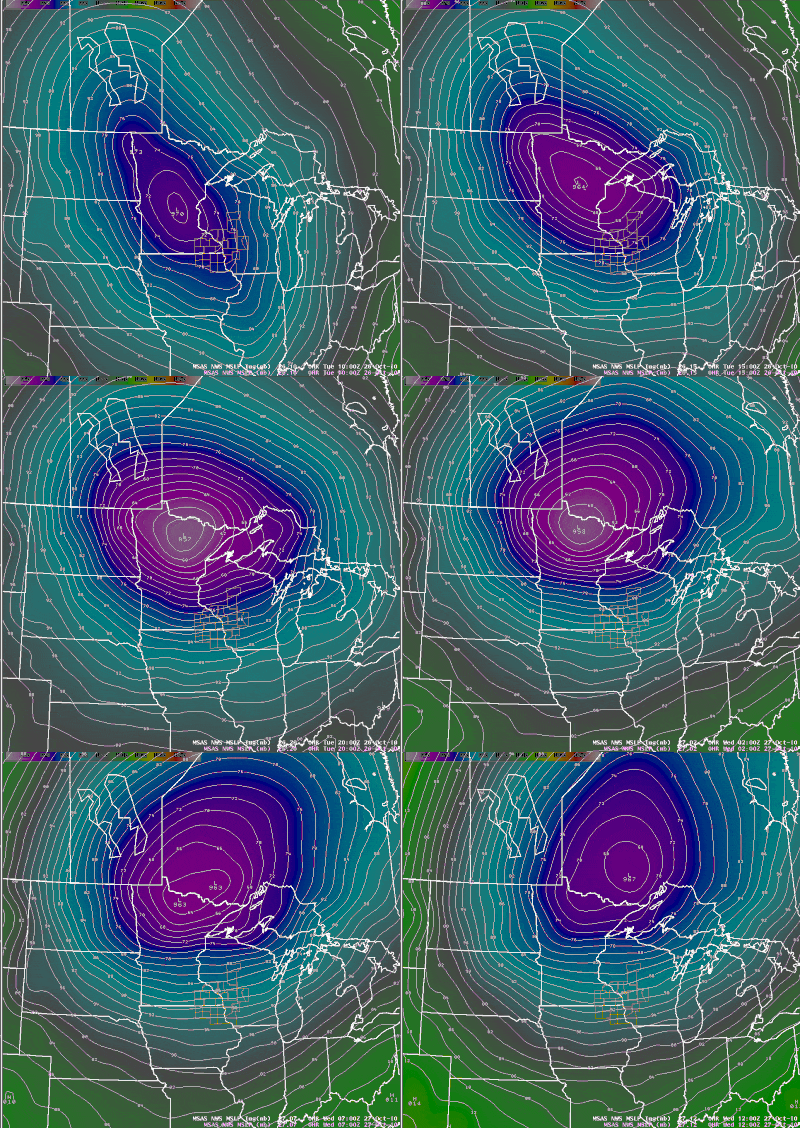 |
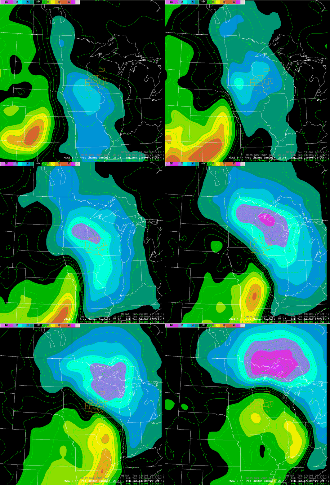
| Animation of surface weather observations, temperature, and isobars (lines of constant pressure) from 7 a.m. Oct. 25 to 7 a.m. Oct. 27. | Animation of 3-hour surface pressure changes from 6 p.m. Oct.25 to 12 Noon Oct.26. Blue/Purple areas are larger pressure falls. Green/Orange areas are larger pressure rises. | Animation of pressure / isobars (lines of constant pressure) from 5 a.m. Oct.26 to 7 a.m. Oct.27. |
 |
 |
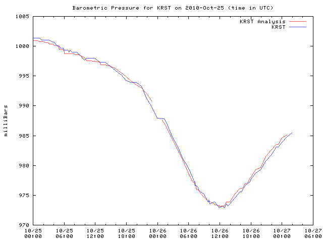 |
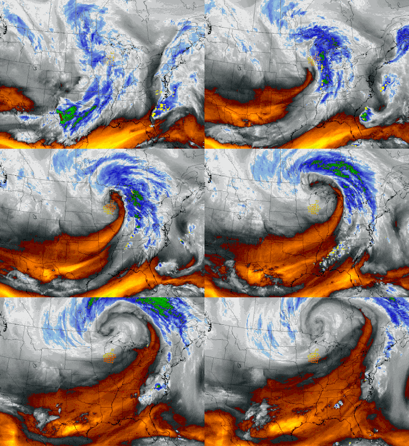
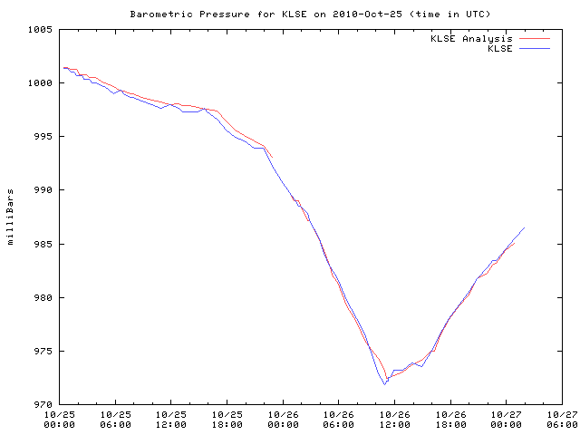
| Water vapor satellite imagery from 8:25 p.m. Oct.25 to 7:31 a.m. Oct.27. | Trace of pressure readings for La Crosse, WI showing the large drop and climb as the storm system passes. | Trace of pressure readings for Rochester, MN showing the large drop and climb as the storm system passes. |
Record Low Pressure
...LOWEST BAROMETRIC PRESSURE RECORD SET IN LA CROSSE WI...
AT 553 AM ON OCTOBER 26TH...THE BAROMETRIC PRESSURE FELL TO
971.4 MILLIBARS /28.685 INCHES OF MERCURY/. THIS JUST BARELY BEAT
THE PREVIOUS RECORD OF 971.6 MILLIBARS /28.691 INCHES OF MERCURY/
ON NOVEMBER 10 1998. THE TABLE BELOW CONTAINS THE FIVE LOWEST
BAROMETRIC PRESSURES AT LA CROSSE WI SINCE 1933.
LOWEST BAROMETRIC PRESSURE READINGS
AT LA CROSSE WI
1933 TO PRESENT
SEA LEVEL
SEA LEVEL PRESSURE
PRESSURE IN INCHES
RANK IN MILLIBARS OF MERCURY DATE TIME
---- ------------ ---------- ---- ----
1 971.4 28.685 10/26/2010 553 AM
2 971.6 28.691 11/10/1998 150 PM
3 971.9 28.700 04/03/1982 900 AM
4 972.6 28.720 11/11/1940 1250 PM +
5 973.8 28.756 01/11/1975 500 AM
+ ARMISTICE DAY STORM
...THIRD LOWEST BAROMETRIC PRESSURE IN ROCHESTER MN...
AT 654 AM ON OCTOBER 26TH...THE BAROMETRIC PRESSURE FELL TO
972.9 MILLIBARS /28.73 INCHES OF MERCURY/ AT ROCHESTER INTERNATIONAL
AIRPORT. THIS WAS THIRD LOWEST BAROMETRIC PRESSURE. THE LOWEST
PRESSURE AT ROCHESTER WAS 964.8 MILLIBARS /28.49 INCHES OF MERCURY/
ON NOVEMBER 10 1998. THE TABLE BELOW CONTAINS THE FIVE LOWEST
BAROMETRIC PRESSURES AT ROCHESTER MN SINCE 1948.
LOWEST BAROMETRIC PRESSURE READINGS
AT ROCHESTER MN
1948 TO PRESENT
SEA LEVEL
SEA LEVEL PRESSURE
PRESSURE IN INCHES
RANK IN MILLIBARS OF MERCURY DATE
---- ------------ ---------- ----
1 964.8 28.49 11/10/1998
2 971.1 28.67 01/11/1975
3 972.9 28.73 10/26/2010
4 974.9 28.79 03/27/1950
5 975.7 28.81 04/03/1982
Peak Wind gusts Oct.26th
...HIGHEST WINDS SORTED BY GUSTS FOR OCTOBER 26TH...
STATION COUNTY TIME SPEED GUST
3 SW BARRE MILLS CWOP     LA CROSSE         820 PM   21 MPH   69 MPH
2 SE EYOTA RWIS           OLMSTED           931 PM   35 MPH   59 MPH
VIROQUA AWOS              VERNON            855 PM   37 MPH   56 MPH
ROCHESTER ASOS            OLMSTED          1054 PM   36 MPH   56 MPH
DODGE CENTER AWOS         DODGE             915 PM   39 MPH   54 MPH
MEDFORD AWOS              TAYLOR           1155 PM   37 MPH   54 MPH
2 N IONIA RWIS            CHICKASAW         736 PM   35 MPH   53 MPH
LA CROSSE NWS CWOP        LA CROSSE         506 PM   26 MPH   52 MPH
1 E MAUSTON RWIS          JUNEAU           1008 PM   18 MPH   52 MPH
1 WNW NECEDAH RAWS        JUNEAU           1148 PM   24 MPH   51 MPH
VOLK FIELD AWOS           JUNEAU            955 PM   25 MPH   51 MPH
PLATTEVILLE AWOS          GRANT            1035 AM   35 MPH   49 MPH
2 ESE CANTON RWIS         FILLMORE          524 PM   35 MPH   49 MPH
CHARLES CITY AWOS         FLOYD             415 PM   26 MPH   48 MPH
4 WSW RINGE CWOP          OLMSTED           703 PM   25 MPH   47 MPH
3 S ROCHESTER CWOP        OLMSTED          1134 AM   22 MPH   47 MPH
AUSTIN AWOS               MOWER            1155 AM   25 MPH   46 MPH
BOSCOBEL ASOS             GRANT            1153 AM   23 MPH   46 MPH
1 E BLACK RIVER FALLS RAWS JACKSON         1115 PM   17 MPH   46 MPH
PRAIRIE DU CHIEN AWOS     CRAWFORD         1055 AM   29 MPH   46 MPH
1 SW MOUNT STERLING RWIS  CRAWFORD          103 PM   28 MPH   46 MPH
1 NE BEAR VALLEY CWOP     WABASHA          1100 PM   31 MPH   46 MPH
1 W PLATTEVILLE CWOP      GRANT             100 PM   30 MPH   46 MPH
4 E NORDNESS RWIS         WINNESHIEK       1223 PM   33 MPH   44 MPH
1 ENE BOSCOBEL RAWS       GRANT             303 PM   17 MPH   43 MPH
1 WNW FRENCH ISLAND RWIS  LA CROSSE         609 PM   17 MPH   40 MPH
SPARTA AWOS               MONROE           1235 PM   23 MPH   39 MPH
ST. ANSGAR CWOP           MITCHELL          538 PM   21 MPH   39 MPH
1 W LA CROSSE CWOP        LA CROSSE         859 PM   24 MPH   39 MPH
KEY TO OBSERVATION TYPES
AWS - SENSORS FROM AWS INCORPORATED. OFTEN LOCATED AT SCHOOLS.
APRS - AUTOMATIC PACKET REPORTING SYSTEM. HAM RADIO WEATHER STATION DATA.
CWOP - CITIZEN WEATHER OBSERVER PROGRAM. HOME WEATHER STATION DATA.
RWIS - ROAD WEATHER INFORMATION SYSTEMS. LOCATED ON MAJOR ROADS AND BRIDGES.
RAWS - FIRE WEATHER OBSERVATIONS. OFTEN LOCATED IN FORESTS.
ASOS/AWOS - AVIATION WEATHER OBSERVATIONS. LOCATED AT AIRPORTS.
OBSERVATIONS ARE COLLECTED FROM A VARIETY OF SOURCES WITH VARYING EQUIPMENT
AND EXPOSURE.  NOT ALL DATA LISTED IS CONSIDERED OFFICIAL.
Peak Wind gusts Oct.27th
PUBLIC INFORMATION STATEMENT
NATIONAL WEATHER SERVICE LA CROSSE WI
115 AM CDT THU OCT 28 2010
...HIGHEST WINDS SORTED BY GUSTS FOR OCTOBER 27TH...
STATION                   COUNTY              TIME    SPEED     GUST
SPRING VALLEY 3E          FILLMORE                            64 MPH
2 SE EYOTA RWIS           OLMSTED           416 AM   41 MPH   63 MPH
1 WNW NECEDAH RAWS        JUNEAU           1248 PM   20 MPH   62 MPH
2 NNE TAMARACK RWIS       TREMPEALEAU       607 AM   35 MPH   61 MPH
LA CROSSE ASOS            LA CROSSE         153 AM   21 MPH   59 MPH
2 ESE CANTON RWIS         FILLMORE         1119 AM   41 MPH   58 MPH
PLATTEVILLE AWOS          GRANT            1255 PM   45 MPH   58 MPH
VIROQUA AWOS              VERNON            215 AM   29 MPH   58 MPH
ROCHESTER ASOS            OLMSTED           154 AM   29 MPH   58 MPH
VOLK FIELD AWOS           JUNEAU            255 AM   28 MPH   56 MPH
DODGE CENTER AWOS         DODGE             655 AM   40 MPH   56 MPH
2 N IONIA RWIS            CHICKASAW         926 AM   40 MPH   55 MPH
1 W PLATTEVILLE CWOP      GRANT            1240 PM   35 MPH   55 MPH
1 ENE BOSCOBEL RAWS       GRANT            1103 AM   24 MPH   54 MPH
CHARLES CITY AWOS         FLOYD            1135 AM   33 MPH   54 MPH
2 SSE KELLOGG RWIS        WABASHA           644 AM    9 MPH   53 MPH
4 E NORDNESS RWIS         WINNESHIEK       1037 AM   26 MPH   52 MPH
MEDFORD AWOS              TAYLOR            455 AM   32 MPH   51 MPH
1 E MAUSTON RWIS          JUNEAU            108 AM   22 MPH   51 MPH
1 SW MOUNT STERLING RWIS  CRAWFORD          403 PM   25 MPH   51 MPH
LA CROSSE NWS CWOP        LA CROSSE         230 AM   22 MPH   51 MPH
PRESTON AWOS              FILLMORE         1036 AM   37 MPH   49 MPH
BOSCOBEL ASOS             GRANT             153 PM   28 MPH   49 MPH
ST. ANSGAR CWOP           MITCHELL          808 AM   38 MPH   49 MPH
4 WSW RINGE CWOP          OLMSTED           513 AM   16 MPH   48 MPH
PRAIRIE DU CHIEN AWOS     CRAWFORD          115 PM   36 MPH   48 MPH
1 WSW ONALASKA CWOP       LA CROSSE         200 PM   24 MPH   48 MPH
MAUSTON CWOP              JUNEAU           1022 AM   36 MPH   48 MPH
1 WSW MAPLE LEAF CWOP     HOWARD           1024 AM   28 MPH   48 MPH
3 NE LUBLIN RAWS          TAYLOR            614 AM   23 MPH   47 MPH
AUSTIN AWOS               MOWER             155 PM   26 MPH   47 MPH
1 NE BEAR VALLEY CWOP     WABASHA           520 AM   40 MPH   46 MPH
2 NE EAST DUBUQUE RWIS    GRANT             403 PM   26 MPH   46 MPH
3 S ROCHESTER CWOP        OLMSTED          1124 AM    6 MPH   46 MPH
DECORAH AWOS              WINNESHIEK       1055 AM   17 MPH   45 MPH
2 N TOMAH RWIS            MONROE           1010 AM   15 MPH   44 MPH
1 E BLK RVR FALLS RAWS    JACKSON          1115 AM   14 MPH   41 MPH
3 N VIROQUA CWOP          VERNON            949 AM   15 MPH   41 MPH
SPARTA AWOS               MONROE           1138 AM   21 MPH   41 MPH
4 NNW RIDGEVILLE RWIS     MONROE           1206 PM   12 MPH   40 MPH
KENDALL CWOP              MONROE           1141 AM   16 MPH   40 MPH
WINONA AWOS               WINONA            734 AM   18 MPH   39 MPH
1 WNW FRENCH ISLAND RWIS  LA CROSSE         210 PM   15 MPH   37 MPH
3 SE WATERVILLE RAWS      ALLAMAKEE        1107 AM   10 MPH   35 MPH
DE SOTO CWOP              CRAWFORD          101 AM   10 MPH   33 MPH
KEY TO OBSERVATION TYPES
AWS - SENSORS FROM AWS INCORPORATED. OFTEN LOCATED AT SCHOOLS.
APRS - AUTOMATIC PACKET REPORTING SYSTEM. HAM RADIO WEATHER STATION DATA.
CWOP - CITIZEN WEATHER OBSERVER PROGRAM. HOME WEATHER STATION DATA.
RWIS - ROAD WEATHER INFORMATION SYSTEMS. LOCATED ON MAJOR ROADS AND BRIDGES.
RAWS - FIRE WEATHER OBSERVATIONS. OFTEN LOCATED IN FORESTS.
ASOS/AWOS - AVIATION WEATHER OBSERVATIONS. LOCATED AT AIRPORTS.
OBSERVATIONS ARE COLLECTED FROM A VARIETY OF SOURCES WITH VARYING EQUIPMENT
AND EXPOSURE.  NOT ALL DATA LISTED IS CONSIDERED OFFICIAL.
 |
Media use of NWS Web News Stories is encouraged! Please acknowledge the NWS as the source of any news information accessed from this site. |
 |