Temperatures:
| During November 2023, average temperatures ranged from 31.9°F at Medford, WI (COOP) to 40.6°F at Gays Mills, WI (COOP) in the Upper Mississippi River Valley. Temperature anomalies ranged from near-normal to 4°F warmer than normal. The warmest temperature was 69°F at Boscobel Airport, WI (ASOS) on November 16. Meanwhile, the coldest temperature was -6°F at Black River Falls, WI (RAWS) on November 28. |
 |
Precipitation:
| During November 2023, it was very dry across the Upper Mississippi River Valley. Precipitation varied from 0.02" at Grand Meadow, MN (COOP) to 0.53" at Medford, WI. Precipitation anomalies ranged from 1.5 to 2.5" drier than normal. The highest one-day precipitation was 0.25" at Gilman 8.2 NNW, WI (CoCoRaHS) from November 1 to November 2, and St. Ansgar, IA (COOP) from November 25 to November 26. |
 |
Several locations had their top 5 driest Novembers.
- Elgin 2 SSW, MN (COOP) received just 0.03" of precipitation. This tied 1976 for the driest November. Records extend back to 1939.
- Grand Meadow, MN (COOP) received just 0.02" of precipitation. This tied 1939 for the 3rd driest November. Only 1903 and 1962 were drier with just a trace of precipitation. Records extend back to 1887.
- Theilman 1 SSW, MN (COOP) received just 0.05" of precipitation. This was the 4th driest November. Only 1939 (0.02"), 1967 (trace), and 1976 (trace). Records extend back to 1938.
Abnormally dry (D0) to moderate (D1) drought continues north of Interstate 90, and abnormally dry (D0) to extreme (D3) drought lingers elsewhere.
Snowfall:
| Monthly snowfall was below to near normal. Snow totals ranged from a trace to 5.2" near Lanesboro, MN. These snow totals were up to 5" below normal. The highest one-day snowfalls were 2.8" at Strawberry Point, IA (COOP) from November 25 to November 26. |
 |
The information below details November 2023 temperatures, precipitation, and snowfall for La Crosse WI, and Rochester MN.
La Crosse, WI
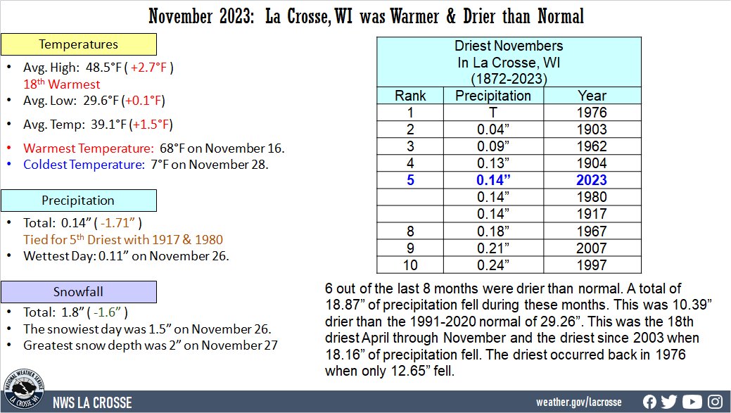
November 2023 was Warmer and Much Drier than Normal at La Crosse WI
...November 2023 Highlights...
Temperatures - Tied for 33rd Warmest
- During November 2023, the average temperature was 39.1°F at La Crosse Regional Airport. This was 1.5°F warmer than the 1991-2020 normal of 37.6°F. This was tied with 1949 for the 32nd warmest November and the warmest since 2020 (41.8°F - 8th warmest November).
- The average high temperature was 48.5°F. This was 2.7°F warmer than the 1991-2020 normal of 45.8°F. This was the 18th warmest.
- The average low temperature was 29.6°F. This was 0.1°F warmer than the 1991-2020 normal of 29.5°F.
|
 |
- The warmest high temperature was 68°F on November 16.
- The coldest high temperature was 24°F on November 27 and November 28.
- The warmest low temperature was 45°F on November 6.
- The coldest low temperature was 7°F on November 28.
Precipitation - Tied for the 5th Driest with 1917 and 1980
- During November 2023, just 0.14 inches of precipitation fell at La Crosse Regional Airport.
- This was 1.71 inches drier than the 1991-2020 normal of 1.85 inches.
- This was tied for the 5th driest November with 1917 and 1980. It was the driest November since 1980.
- The driest November occurred in 1976 when just a trace of precipitation fell.
Below is the table of the ten driest Novembers at La Crosse, WI.
Ten Driest Novembers
in La Crosse, WI
1872-2023
Precipitation
Rank Total Year
---- ------------- ----
1 Trace 1976
2 0.04 inches 1903
3 0.09 inches 1962
4 0.13 inches 1904
5 0.14 inches 2023
0.14 inches 1980
0.14 inches 1917
8 0.18 inches 1967
9 0.21 inches 2007
10 0.24 inches 1997
- 6 out of the last 8 months were drier than normal. A total of 18.87 inches of precipitation fell during these months. This was 10.39 inches drier than the 1991-2020 normal of 29.26 inches. This was the 18th driest April through November and the driest since 2003 when 18.16 inches of precipitation fell. The driest occurred back in 1976 when only 12.65 inches fell. Due to the lack of precipitation, much of La Crosse County is in moderate (D1) drought.
- The wettest day occurred on November 26 when 0.11 inches of precipitation fell.
- Precipitation fell on 7 days (23.3%). Measurable precipitation fell on 3 days (10%) and trace amounts on 4 days (13.3%).
Snowfall - Below Normal
- During November 2023, the snow observer near La Crosse Regional Airport reported 1.8 inches of snow. This was 1.6 inches below the 1991-2020 normal of 3.4 inches.
- The snowiest day was 1.5 inches on November 26.
- Snow was on the ground for 5 days (16.7%). Measurable snow was on the ground for 4 days (13.3%) and a trace of snow on another day (3.3%).
- The greatest snow depth was 2 inches on November 27.
Snow Depth - Below Normal
- During November 2023, the snow observer near La Crosse Regional Airport reported an average snow depth of 0.2 inches. This was 0.2 inches below the 1893-2023 long-term average of 0.4 inches.
- Snow was on the ground 4 days (13.3%). Measurable snow was on the ground for 4 days (13.3%).
...Records...
...Looking ahead to December...
- The normal high temperature in La Crosse starts off at 38°F on December 1st and falls to 26°F by the end of the month. The normal low temperature starts off at 23°F on the 1st and falls to 10°F by the end of the month. The warmest December temperature on record is 69°F on December 15, 2021, and the coldest is -37°F on December 24, 1872.
- The normal mean temperature for December is 25.1°F. La Crosse’s warmest December occurred in 1877 with an average temperature of 38.9°F, and their coldest December occurred in 1983 with an average temperature of 6.4°F.
- The normal December precipitation is 1.49 inches. The wettest December occurred in 2015 with 4.93 inches of precipitation and the driest December occurred in 1943 with just 0.01 inches. The wettest December day occurred on December 13, 2015, when 1.71 inches of precipitation fell.
- The normal December snowfall is 10.9 inches (2nd snowiest month). The snowiest December occurred in 2008 with 32.7 inches of snow and the least snow was a trace in 1943, 1979, and 2006. The snowiest December day occurred on December 7, 1927 (La Crosse's snowiest day), when 16.7 inches of snow fell.
Rochester
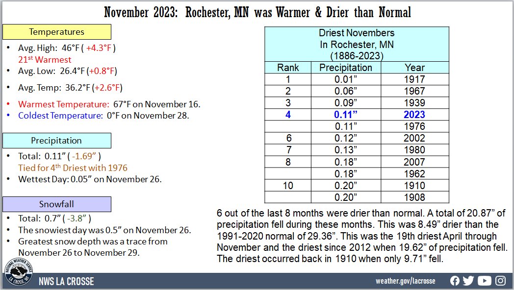
November 2023 was Warmer and Much Drier than Normal at Rochester MN
...November 2023 Highlights...
Temperatures - Tied for 31st Warmest with 1962
- During November 2023, the average temperature was 36.2°F at Rochester International Airport. This was 2.6°F warmer than the 1991-2020 normal of 33.6°F. This tied 1962 for the 31st warmest November. This was the warmest November since 2020 (37.9°F - 12th warmest).
- The average high temperature was 46°F. This was 4.3°F warmer than the 1991-2020 normal of 41.7°F. This was the 21st warmest.
- The average low temperature was 26.4°F. This was 0.8°F warmer than the 1991-2020 normal of 25.6°F.
|
 |
- The warmest high temperature was 67°F on November 16.
- The coldest high temperature was 19°F on November 27.
- The warmest low temperature was 39°F on November 6.
- The coldest low temperature was 0°F on November 28.
Precipitation - Tied for the 4th Driest with 1976
- During November 2023, just 0.11 inches of precipitation fell at Rochester International Airport.
- This was 1.69 inches drier than the 1991-2020 normal of 1.80 inches.
- This was tied with 1976 for the 4th driest November. It was the driest November since 1976.
- The driest November occurred in 1917 when just 0.01 inches of precipitation fell.
Below is the table of the ten driest Novembers at Rochester, MN.
Ten Driest Novembers
in Rochester, MN
1886-2023
Precipitation
Rank Total Year
---- ------------- ----
1 0.01 inches 1917
2 0.06 inches 1967
3 0.09 inches 1939
4 0.11 inches 2023
0.11 inches 1976
6 0.12 inches 2002
7 0.13 inches 1980
8 0.18 inches 2007
0.18 inches 1962
10 0.20 inches 1910
0.20 inches 1908
- 6 out of the last 8 months were drier than normal. A total of 20.87 inches of precipitation fell during these months. This was 8.49 inches drier than the 1991-2020 normal of 29.36 inches. This was the 19th driest April through November and the driest since 2012 when 19.62 inches of precipitation fell. The driest occurred back in 1910 when only 9.71 inches fell. Due to the lack of precipitation, Olmsted County remains abnormally dry (D0) to moderate (D1) drought.
- The wettest day occurred on November 26 when 0.05 inches of precipitation fell.
- Precipitation fell on 9 days (30%). Measurable precipitation fell on 5 days (16.7%) and trace amounts on 4 days (13.3%).
Snowfall - Below Normal
- During November 2023, the snow observer near Rochester International Airport reported 0.7 inches of snow. This was 3.8 inches below the 1991-2020 normal of 4.5 inches.
- The snowiest day was 0.5 inches on November 26.
- Snow fell on 3 days (10%). Measurable snow fell on 2 days (6.7%) and trace amounts of snow fell on another day (3.3%).
Snow Depth - Below Normal
- During November 2023, the snow observer near Rochester International Airport reported an average snow depth of 0 inches. This was 0.6 inches below the 1931-2023 long-term average of 0.6 inches.
- Snow was on the ground 4 days (13.3%). On all 4 days, this snow on the ground was just a trace.
- The greatest snow depth was a trace from November 26-29.
...Records...
...Looking ahead to December...
- The normal high temperature in Rochester starts off at 34°F on December 1st and falls to 24°F by the end of the month. The normal low temperature starts off at 19°F on the 1st and falls to 9°F by the end of the month. The warmest December temperature on record is 64°F on December 4, 2017, and December 15, 2021, and the coldest is -33°F on December 19, 1983.
- The normal mean temperature for December is 20.8°F. Rochester’s warmest December occurred in 1931 with an average temperature of 30.7°F, and its coldest December occurred in 1983 with an average temperature of 2.9°F.
- The normal December precipitation is 1.28 inches. The wettest December occurred in 2010 with 3.68 inches of precipitation and the driest December occurred in 1943 with only a trace. This tied March 1910 and June 1910 for their driest month. The wettest December day occurred on December 11, 2010, when 1.36 inches of precipitation fell.
- The normal December snowfall is 12.4 inches. The snowiest December occurred in 2010 with 41.3 inches of snow. This was their snowiest month. The least snow was a trace in 1913 and 1943. The snowiest December day occurred on December 11, 2010, when 15 inches of snow fell.
