Upper Mississippi River Climate Summary for June 2024:
Temperatures - Near Normal
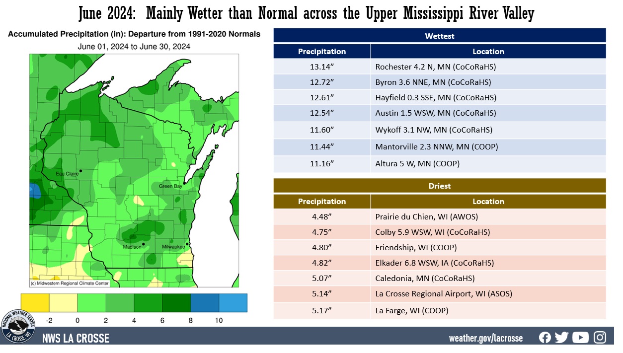
- During June 2024, average temperatures ranged from 63.1°F at Medford Taylor County Airport (AWOS) and near Owen, WI (COOP) to 71.5°F at Guttenberg Lock & Dam 10, IA (COOP).
- Temperature anomalies ranged from 2°F below normal to 2°F above normal.
- There was a 56°F difference between the warmest and coldest temperatures in the Upper Mississippi River Valley.
- The warmest temperature was 92°F at Boscobel Airport, WI (ASOS) on June 18 and near Elkader (COOP) on June 26. Meanwhile, the coldest temperature was 36°F at Sparta, WI (AWOS) on June 11.
|
 |
Precipitation - Wetter than Normal
- Precipitation totals varied from 4.48" at Prairie du Chien Airport, WI (AWOS) to 13.14" at Rochester, MN (CoCoRaHS).
- Precipitation anomalies ranged from near normal to 8" wetter than normal.
- The highest one-day precipitation was 5.61" near Wykoff (CoCoRaHS) on June 22.
|
 |
| 2023-24 Seasonal Snowfall - Below Normal |
- Seasonal snowfall (July 1 through June 30) varied from 13.2" at Minnesota City Dam 5, MN (COOP) to 47.4" at La Farge, WI (COOP).
- Snowfall anomalies ranged from near normal to 30” below normal.
- The highest one-day snowfall was 12.5" at La Farge, WI (COOP) from January 12 to January 13.
|
 |
Below are the June 2024 climate summaries for La Crosse, WI, and Rochester, MN.
La Crosse, WI
June 2024 was Slightly Colder and Wetter than Normal at La Crosse, WI
...June 2024 Highlights...
Temperatures - Slightly Colder than Normal
- The average temperature was 70.1°F at La Crosse Regional Airport. This was 0.9°F colder than the 1991-2020 normal of 71°F.
- This was the first month to average colder than normal since July 2023 (72.7°F or 2.3°F below normal).
- The average high temperature was 79.9°F. This was 1.8°F below the 1991-2020 normal of 81.7°F.
- The average low temperature was 60.2°F. This was 0.2°F below the 1991-2020 normal of 60.4°F.
|
 |
- The hottest temperature was 91°F on June 16 and the coldest temperature was 49°F on June 10.
- There were 2 days in which the temperature reached or exceeded 90°F. Normally there are 3 days.
Precipitation - Near Normal
- A total of 5.14" of rain fell. This was 0.06" wetter than the 1991-2020 normal of 5.08".
- This was 3rd month in a row to be wetter than normal.
- Measurable rain fell on 16 days (53.3%) and trace amounts on another 8 days (26.7%).
- The 24 days with rain was the most in June. The previous record was 22 days in 1935 (17 days with measurable rain and 5 days with a trace) and 2013 (16 days with measurable rain and 6 days with a trace). The most June days with measurable rain is 19 days in 2010. The least is 4 days in 1910.
- The wettest day was June 28 when 1.46" of rain fell.
2023-24 Snow Season - 11th Least
- During the 2023-24 snow season (July 1-June 30), the official NWS snow observer near La Crosse Regional Airport observed 26".
- This was 20.3" below the 1991-2020 normal of 46.3".
- This was the 11th least.
- It was the least snow since the 2011-12 snow season (20.6 inches - 4th least).
- The snowiest day was 6.6" on January 12.
- The greatest snow depth was 12" on January 14.
Mississippi River at La Crosse - 2nd highest June average stage
- During June, the average 7 AM stage for the Mississippi River at La Crosse was 11.01 feet. This was the 2nd highest June monthly average. Only 1943 was greater with an average of 11.24 feet.
- The highest 7 AM stage in June 2024 was 14.42 feet on June 30. The previous record was 14.1 feet on June 26-27, 1993. Records extend back to April 1, 1937.
- There were 5 daily record high stages either tied or broken in June on the Mississippi River at La Crosse, WI.
June 2024 Daily Stage Records
for the Mississippi River
at La Crosse, WI
1937-2024
New Record Old Record
---------- ----------
June 12 11.06 feet 11.06 feet in 1944
June 27 14.12 feet 14.10 feet in 1993
June 28 14.18 feet 14.00 feet in 1993
June 29 14.30 feet 13.90 feet in 1993
June 30 14.42 feet 13.80 feet in 1993
...Records...
- Monthly Records...
- Most days with rain (24 days) in June - Previous record was 22 days in 1935 and 2013.
...Looking Ahead to July...
- The normal high temperature in La Crosse is 85.4°F and the normal low temperature is 64.5°F. The normal monthly mean temperature is 75.0°F. La Crosse’s hottest July occurred in 2012 with an average temperature of 79.6°F and their coldest July occurred in 1891 with an average of 66.9°F.
- For July, the hottest temperature was 108°F (also the hottest temperature for any day of the year) on July 14, 1936, and July 13, 1995, and the coldest temperature was 44°F on July 4, 1967. There are typically 7 days with temperatures at or above 90°F.
- The normal precipitation for July is 4.23". The wettest July occurred in 1883 when 11.03" of rain fell and the driest occurred in 1967 when 0.16" of rain fell. The wettest July day was 5.24" on July 27, 1987. Normally, there are 7 days with thunderstorms.
Rochester, MN
June 2024 was Very Wet and Slightly Warmer than Normal at Rochester MN
...June 2024 Highlights...
Temperatures - Slightly Warmer than Normal
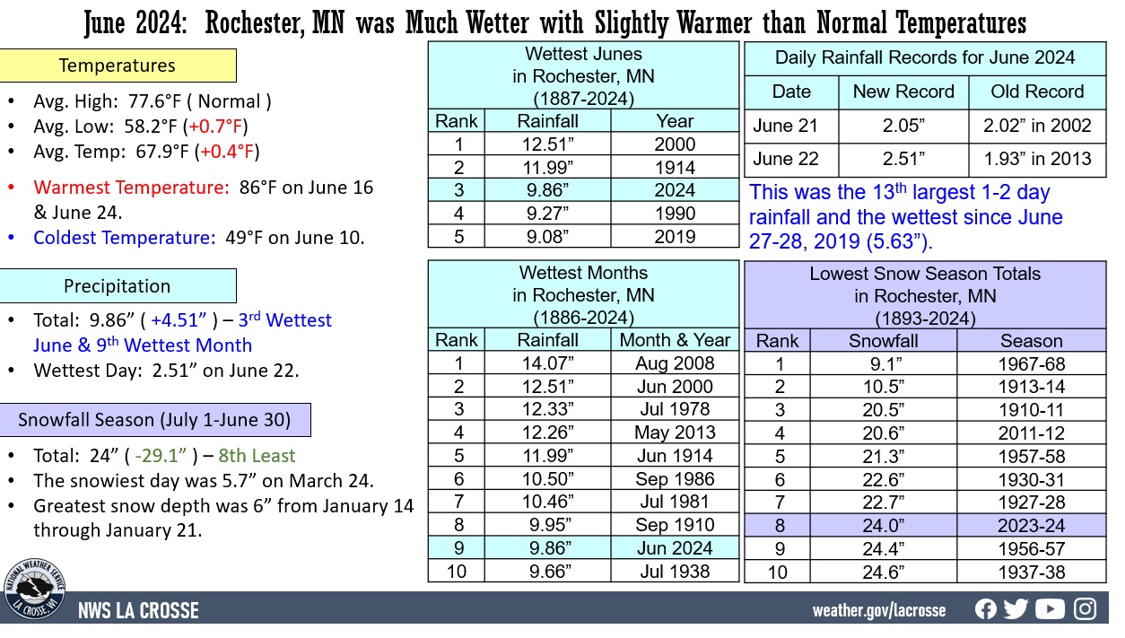
- The average temperature was 67.9°F at Rochester International Airport. This was 0.4°F warmer than the 1991-2020 normal of 67.5°F.
- This was the 11th consecutive month to average warmer than normal. July 2023 was the last month to average colder than normal. That month had an average temperature of 69.4°F which was 1.1°F colder than the 1991-2020 normal of 70.5°F.
- The average high temperature was 77.6°F. This is normal.
- The average low temperature was 58.2°F. This was 0.7°F above the 1991-2020 normal of 57.5°F.
|
 |
- The hottest temperature was 86°F on June 16 and June 24 and the coldest temperature was 49°F on June 10.
- There were no days in which the high temperature reached or exceeded 90°F. Normal is 2 days.
Precipitation - 3rd Wettest June and 9th Wettest Month
- A total of 9.86" of rain fell.
- This was 4.51" wetter than the 1991-2020 normal of 5.35 inches.
- This was the 3rd wettest June. Only 2000 (12.51 inches) and 1914 (11.99 inches) were wetter.
- Below are the ten wettest Junes in Rochester.
Wettest Junes
in Rochester, MN
1887-2024
Rank Rainfall Year
---- -------- ----
1 12.51 inches 2000
2 11.99 inches 1914
3 9.86 inches 2024
4 9.27 inches 1990
5 9.08 inches 2019
6 8.53 inches 2004
7 8.34 inches 1967
8 8.20 inches 2002
9 7.79 inches 2010
10 7.44 inches 1993
- This June was the 9th wettest month and the wettest month since May 2013 (12.26"). The wettest month was 14.07" in August 2008. Below are the ten wettest months in Rochester.
Wettest Months
in Rochester, MN
1886-2024
Rank Rainfall Month
---- -------- -----
1 14.07 inches Aug 2008
2 12.51 inches Jun 2000
3 12.33 inches Jul 1978
4 12.26 inches May 2013
5 11.99 inches Jun 1914
6 10.50 inches Sep 1986
7 10.46 inches Jul 1981
8 9.95 inches Sep 1910
9 9.86 inches Jun 2024
10 9.66 inches Jul 1938
- Measurable rain fell on 19 days (63.3%) and trace amounts on another 4 days (13.3%). The 23 days with rain were tied with 2010 (20 days with measurable rain and 3 days with a trace) for 2nd most in June. The record was 24 days (20 days with measurable rain and 3 days with a trace) in 2014.
- The most June days with measurable rain is 20 days in 2010. The least is 29 days in 1910 (there was a trace of rain on June 12 - otherwise there was no rain).
- The wettest day was June 22 when 2.51" of rain fell. This was the wettest calendar day since July 23, 2022 (3.09").
- The 2-day rainfall on June 21-22 of 4.56" was the 13th wettest 1 and 2-day rainfall and wettest since June 27-28, 2019 (5.63"). The wettest was 7.47" on July 11, 1981.
2023-24 Snow Season - 8th Least
- During the 2023-24 snow season (July 1-June 30), the official NWS snow observer near Rochester International Airport observed 24".
- This was 29.1" below the 1991-2020 normal of 53.1 inches. This was the 8th least. It was the least since the 2011-12 snow season (20.6" - 4th least).
- The snowiest day was 5.7" on March 24.
- The greatest snow depth was 6" from January 14 through January 21.
...Records...
- Daily Records...
- June 21 - Wettest - 2.05 inches - Previous Record was 2.02 inches in 2002
- June 22 - Wettest - 2.51 inches - Previous Record was 1.93 inches in 2013
...Looking Ahead to July...
- The normal high temperature in Rochester is 80.3°F and the normal low temperature is 60.8°F. The normal monthly mean temperature is 70.5°F. Rochester’s hottest July occurred in 1936 with an average temperature of 77.7°F, and its coldest July occurred in 1992 with an average temperature of 64.2°F.
- For July, the hottest temperature was 108°F on July 14, 1936 (also the hottest temperature for any day of the year), and the coldest temperature was 40°F on July 17, 1911. There are typically 2 days with temperatures at or above 90°F. There are typically 2 days with temperatures at or above 90°F.
- The normal precipitation for July is 4.19". The wettest July occurred in 1978 when 12.33" of rain fell and the driest occurred in 1946 when 0.41" of rain fell. The wettest July day was 7.47" on July 11, 1981. Normally, there are 7 days with thunderstorms.
