Overview
|
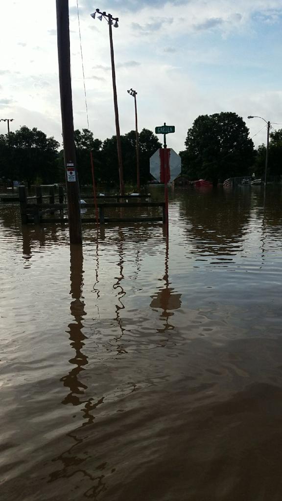
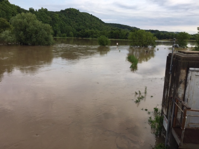
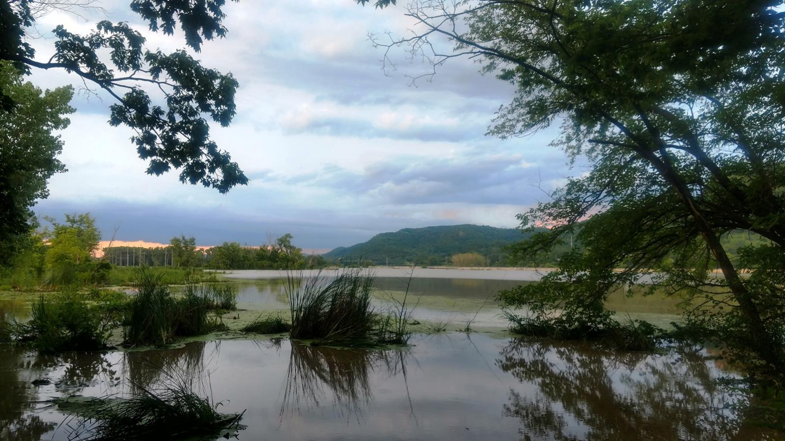
A line of thunderstorms moved through parts of the region during the later afternoon and evening of July 19th. It produced damaging wind gusts over parts of southeast Minnesota, northeast Iowa, into southwest Wisconsin. There was at least three tornadoes - one EF-1 in McGregor, IA, an EF-0 in Howard County, IA, and an EF-1 in Fillmore County, MN. The strong wind cores hit areas between Claremont and West Concord, MN in Dodge County, from Osage to Alta Vista, IA, and in the McGregor, IA area. Numerous wind gusts of 70 mph or slightly higher were received. Later in the evening, storms redeveloped further north in western Wisconsin. These repeatedly hit the same areas just east of the Mississippi River into the Wisconsin River valley. Many towns were flooded out by 6-8" of rain and many rivers rose or will rise to major flood stage.
|
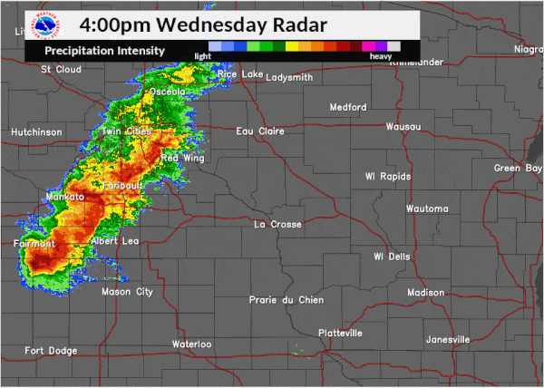 Loop of radar imagery between 4:00-9:00 p.m. on July 19th |
Tornadoes:
|
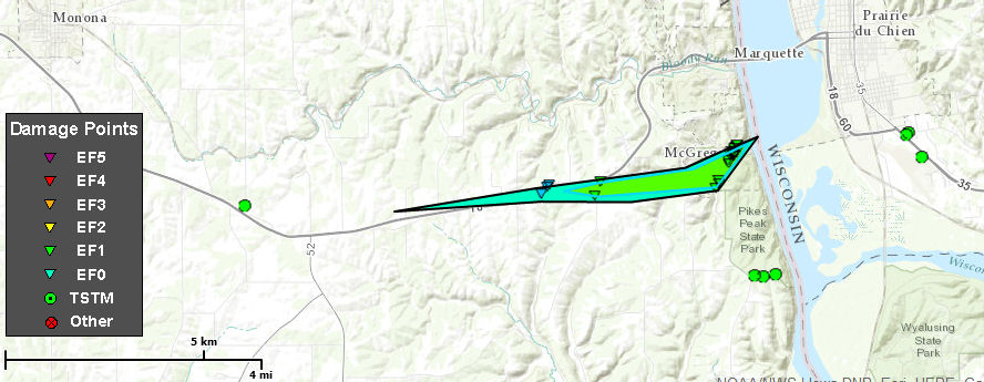
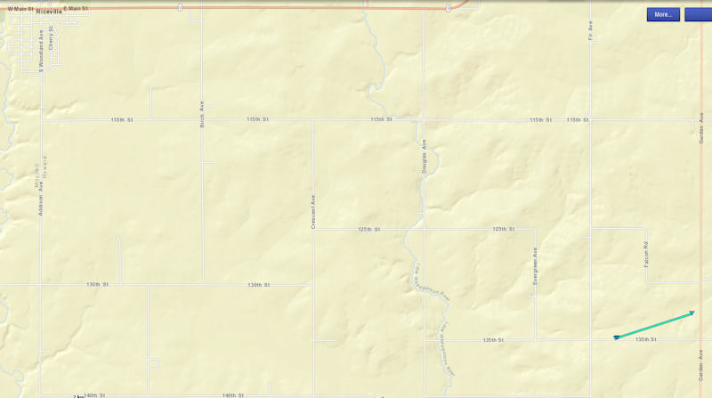
Tornado - McGregor, Iowa
|
||||||||||||||||
|
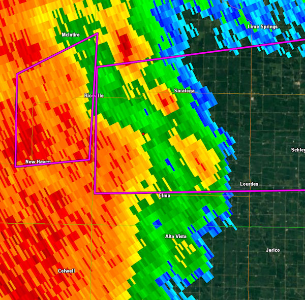
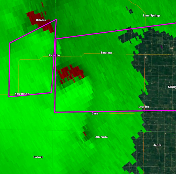
Tornado - Saratoga, Iowa
|
||||||||||||||||
|
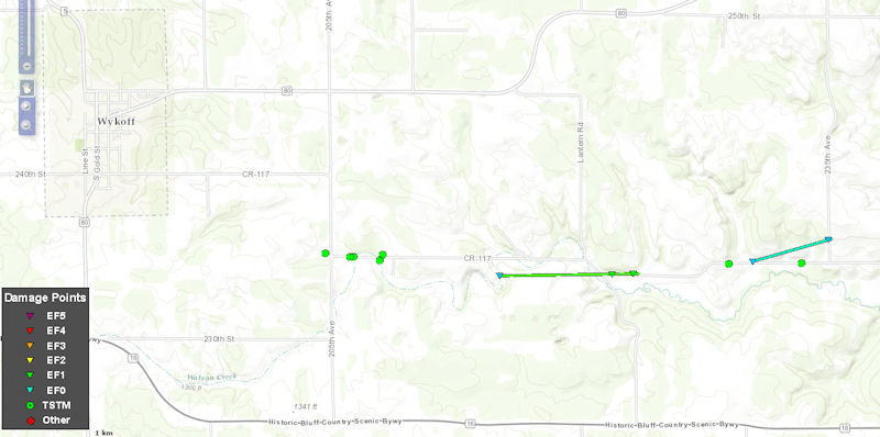
Tornado - Wykoff, Minnesota
|
||||||||||||||||
|
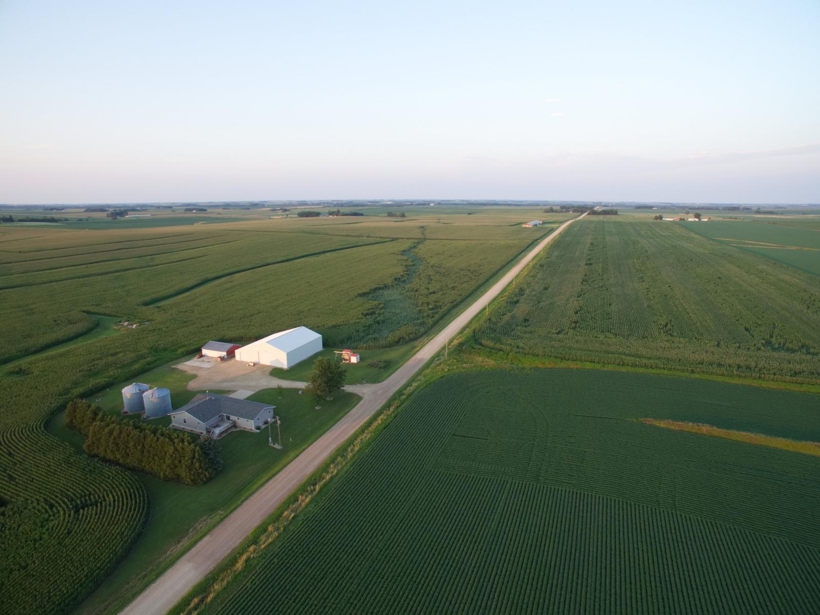
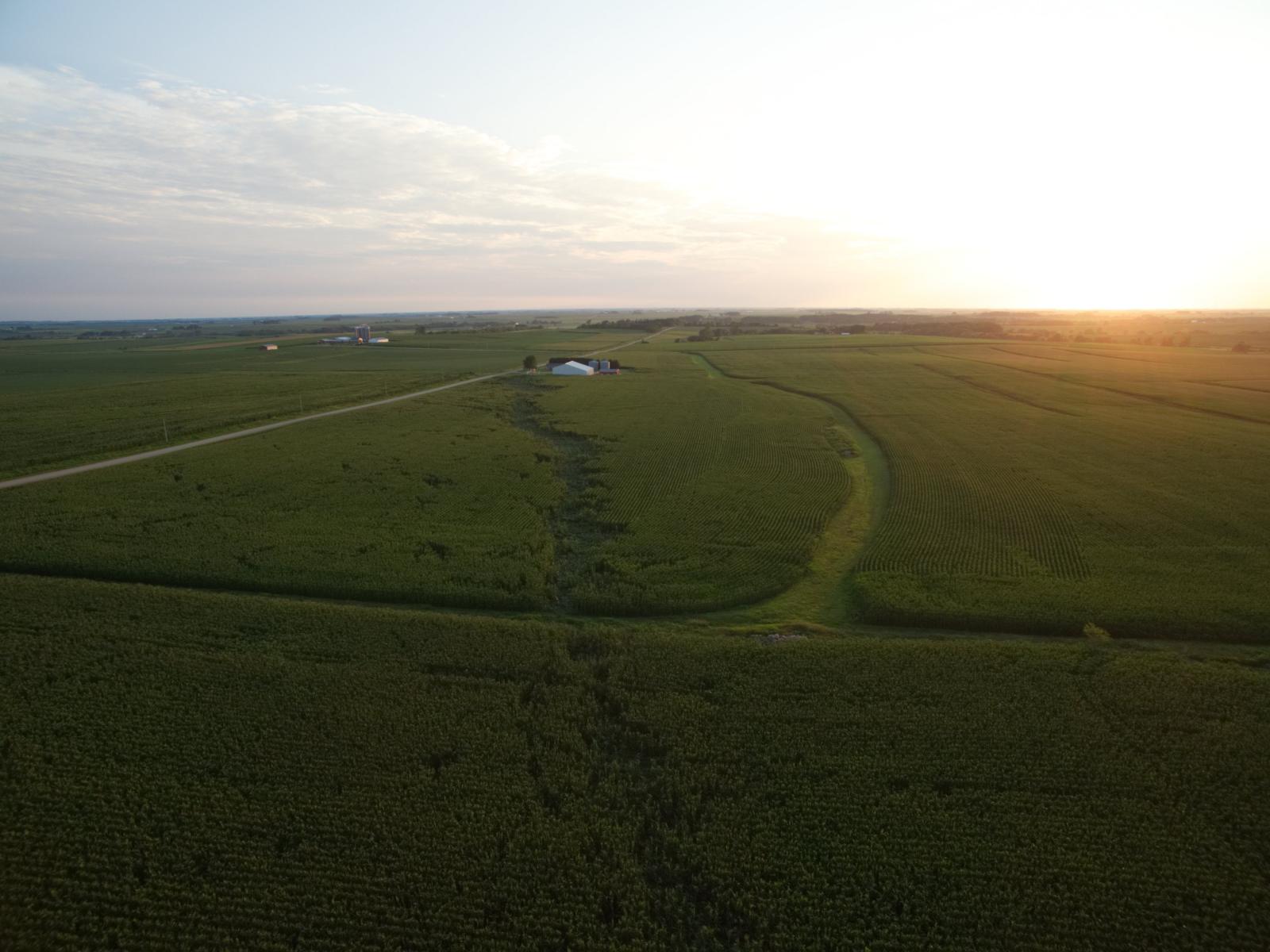
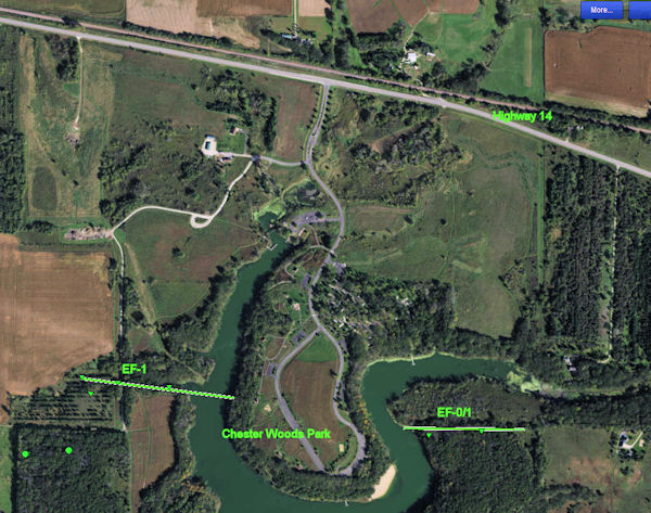
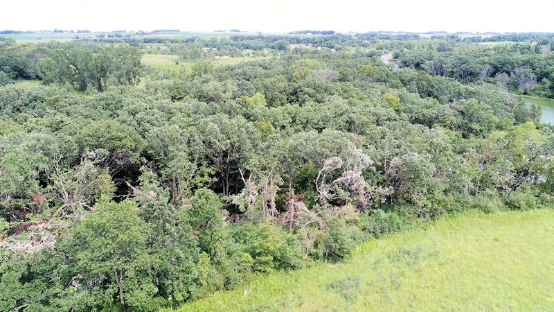
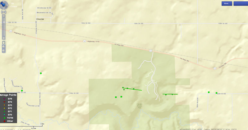
Tornado - Chester, Minnesota
|
||||||||||||||||
The Enhanced Fujita (EF) Scale classifies tornadoes into the following categories:
| EF0 Weak 65-85 mph |
EF1 Moderate 86-110 mph |
EF2 Significant 111-135 mph |
EF3 Severe 136-165 mph |
EF4 Extreme 166-200 mph |
EF5 Catastrophic 200+ mph |
 |
|||||
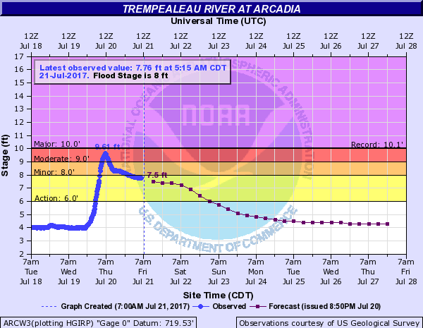
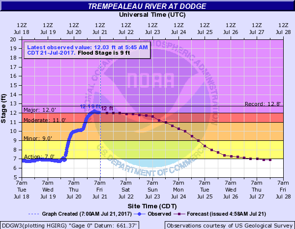
Hydrographs
 |
 |
 |
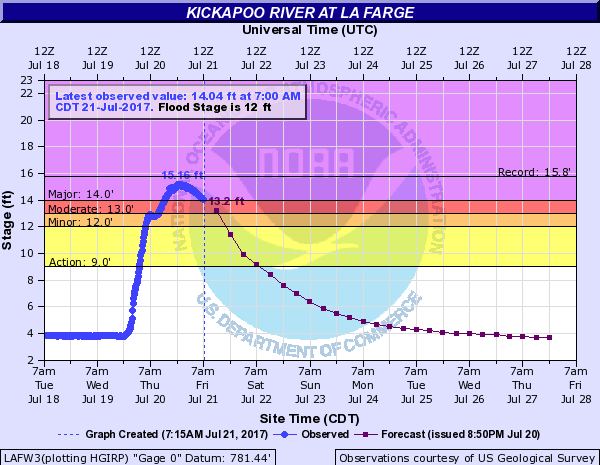 |
| Trempealeau River at Arcadia, WI | Trempealeau River at Dodge, WI | Kickapoo River at Ontario, WI | Kickapoo River at La Farge, WI |
 |
 |
 |
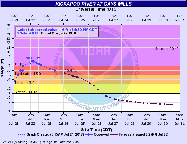 |
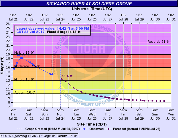
| Kickapoo River at Viola, WI | Kickapoo River at Readstown, WI | Kickapoo River at Soldiers Grove, WI | Kickapoo River at Gays Mills, WI |
 |
|||
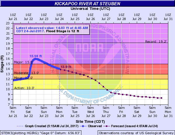
| Kickapoo River at Steuben, WI |
Photos:
 |
 |
 |
 |
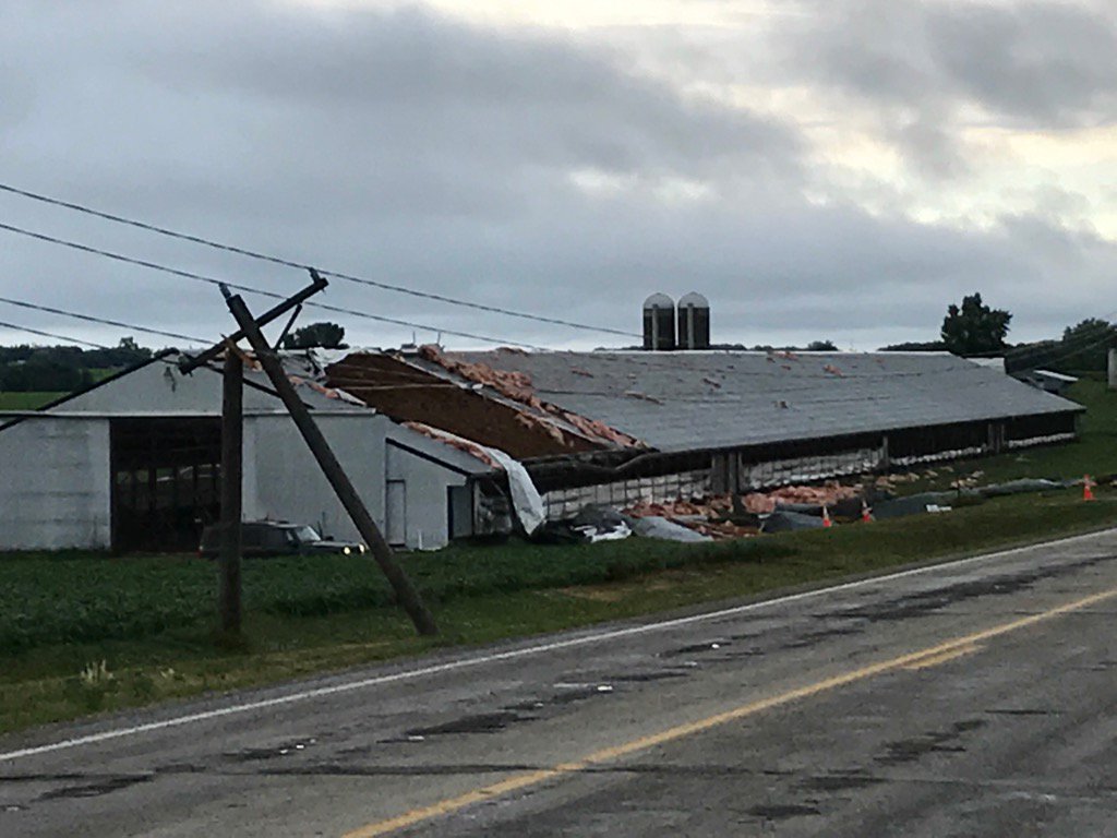
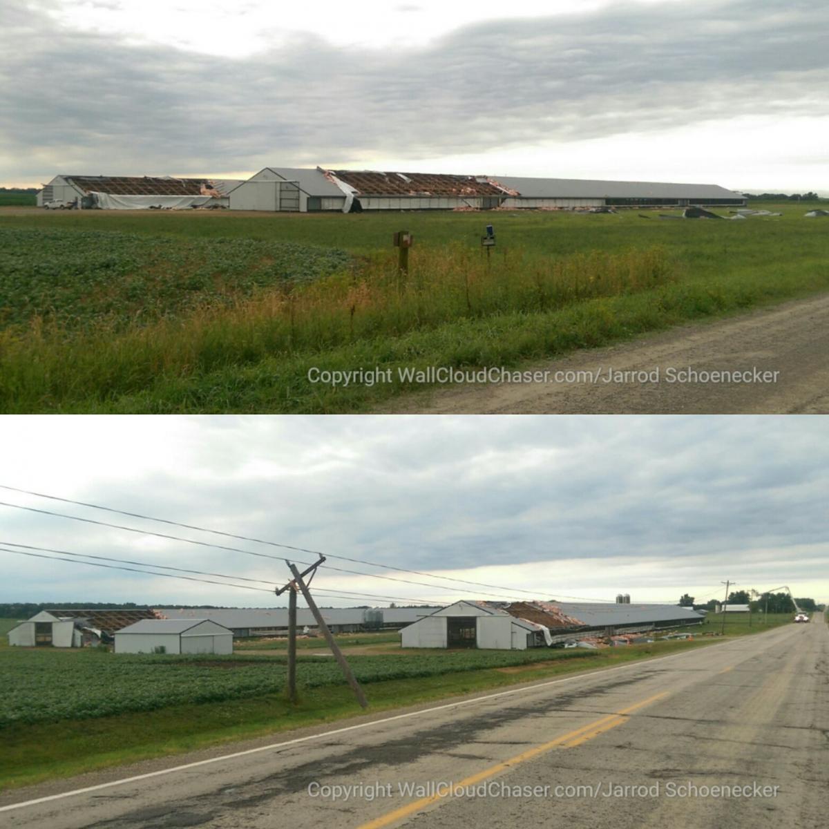
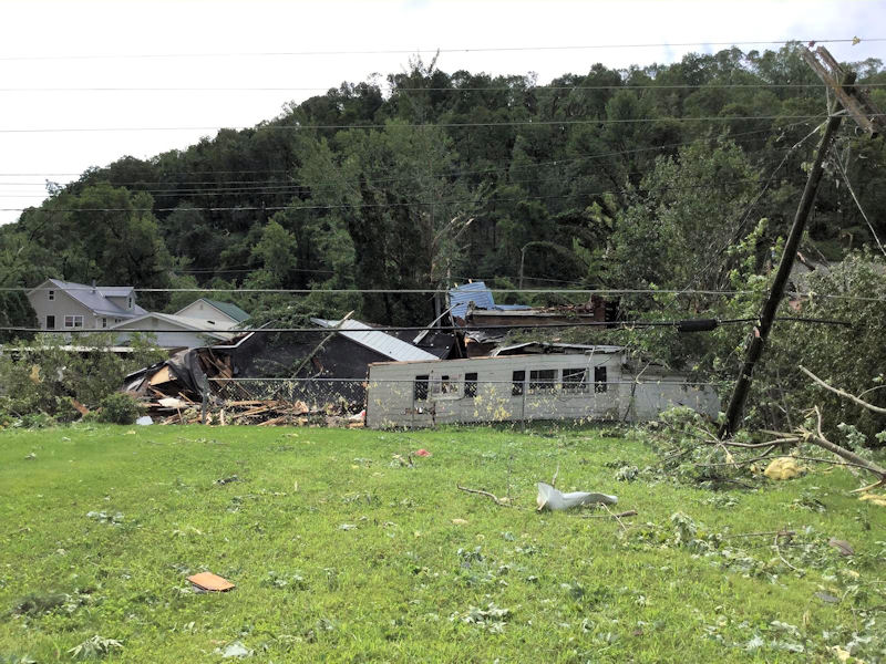
| Turkey farm damage in Dodge Co., MN (Photo by Jim Peterson/KAAL) |
Turkey farm damage in Dodge Co., MN (Photo by Jarrod Schoenecker) |
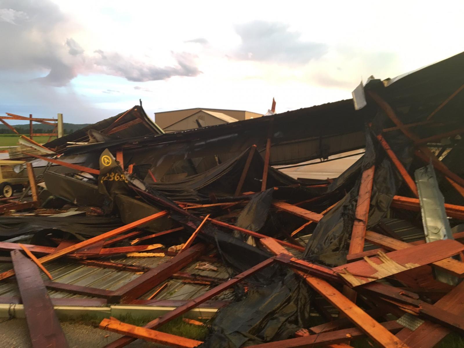
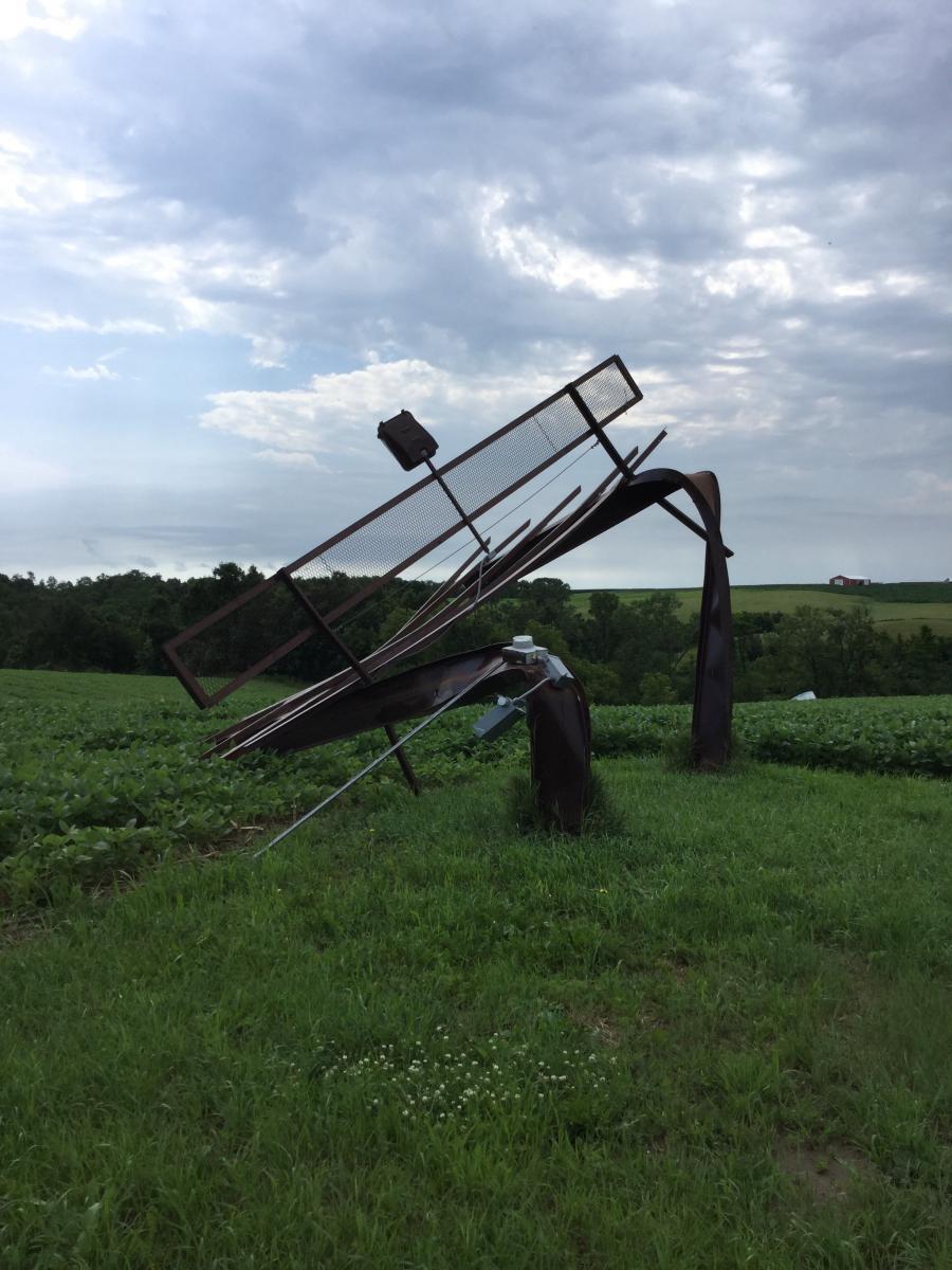
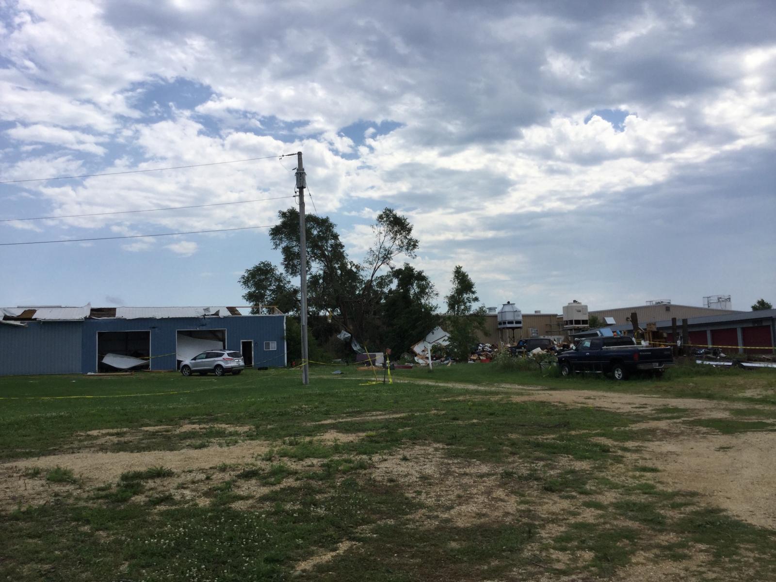
Damage to hanger at Prairie du Chien, WI Airport (Photo by Chris Gothner) |
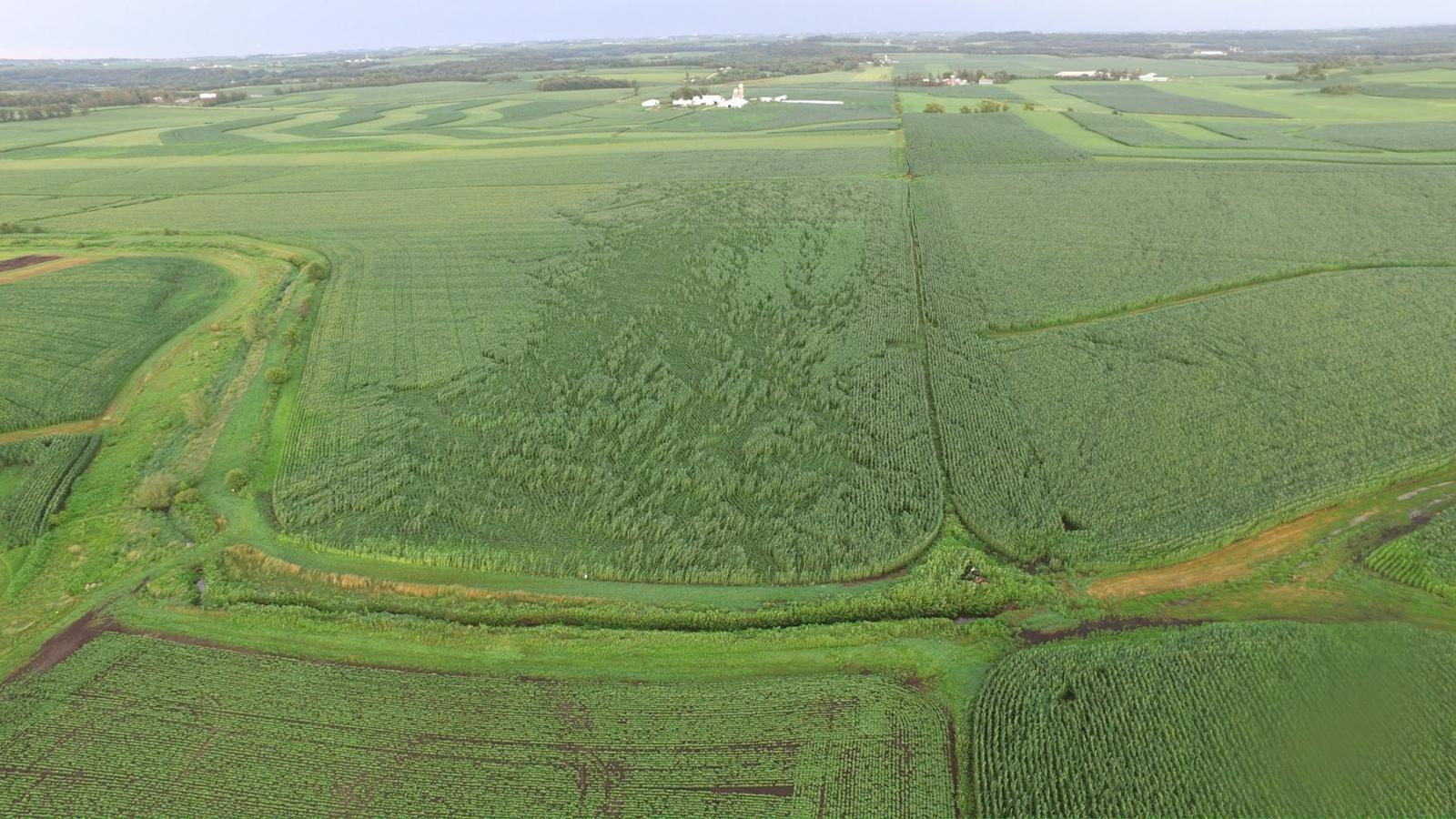
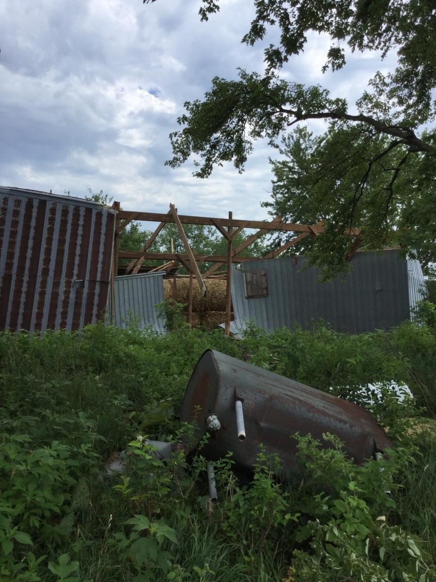
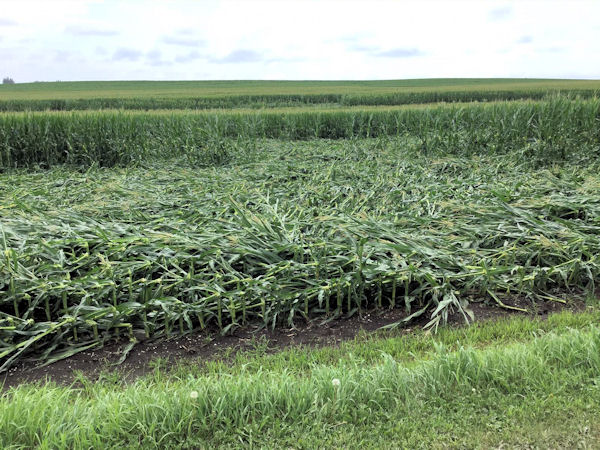
Aerial view of crop damage near Ft.Atkinson, IA (Photo courtesy of Winneshiek Co. Emerg. Management) |
 |
 |
 |
 |
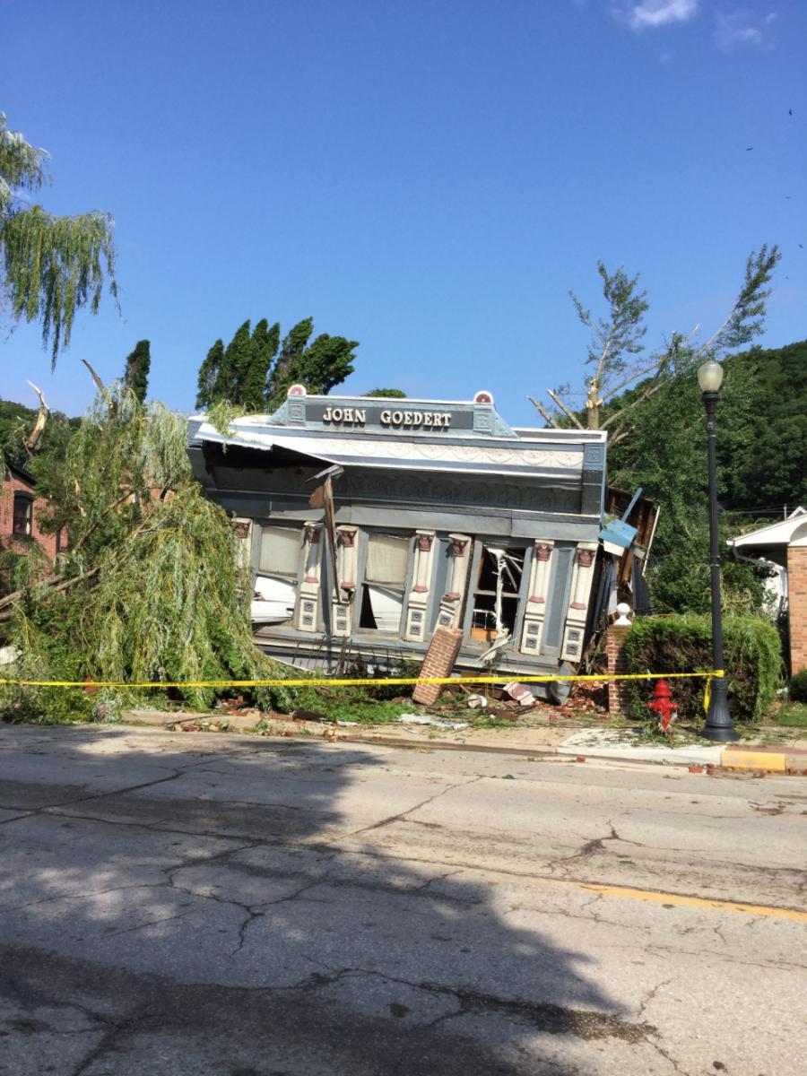
| McGregor, Iowa Tornado Damage (NWS Survey) |
McGregor, Iowa Tornado Damage (NWS Survey) |
McGregor, Iowa Tornado Damage (NWS Survey) |
McGregor, Iowa Tornado Damage (NWS Survey) |
 |
 |
 |
 |
| McGregor, Iowa Tornado Damage (NWS Survey) |
McGregor, Iowa Tornado Damage (NWS Survey) |
McGregor, Iowa Tornado Damage (NWS Survey) |
Damaged sign outside of McGregor, IA (NWS Survey) |
 |
 |
 |
 |
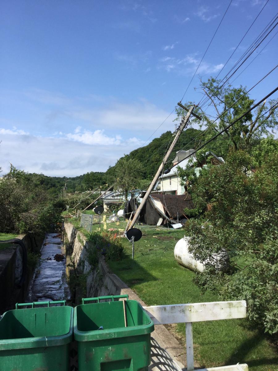
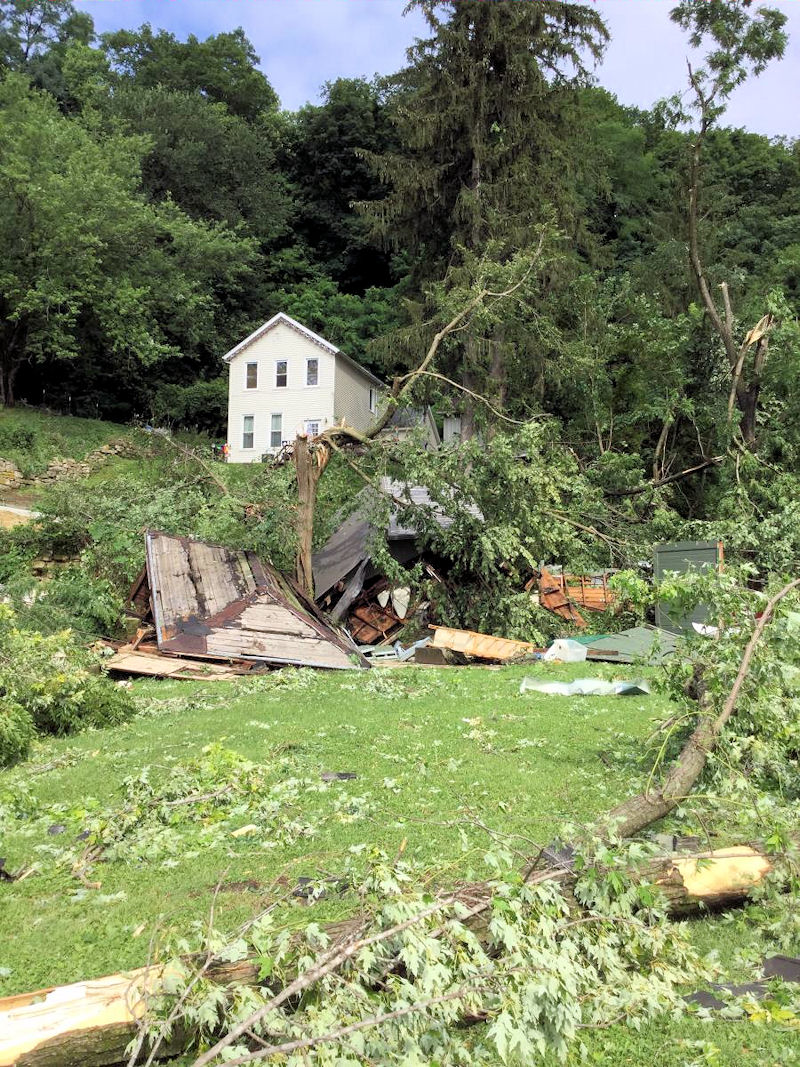
| Storm damage near Fort Atkinson, IA (NWS Survey) |
Storm damage near Fort Atkinson, IA (NWS Survey) |
Storm damage near Fort Atkinson, IA (NWS Survey) |
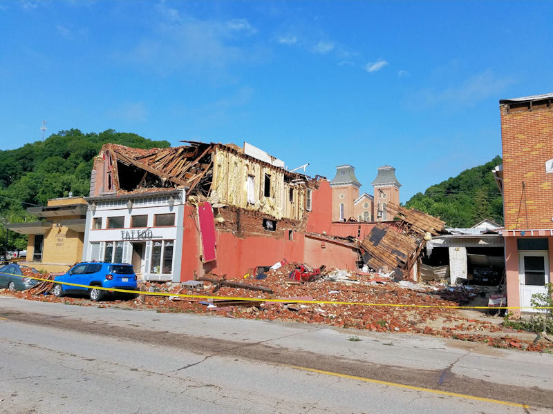
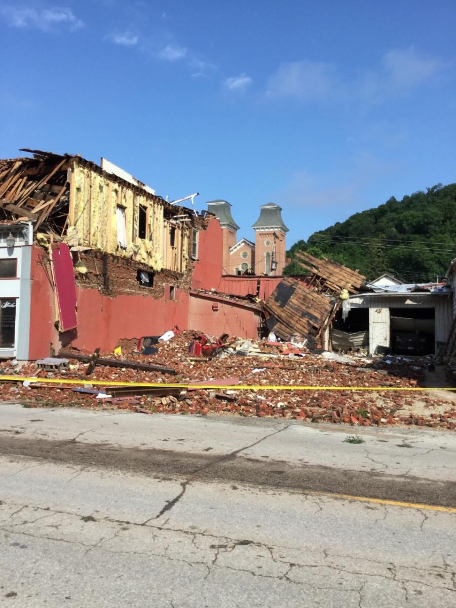
Damaged buildings in Prairie du Chien, WI (NWS Survey) |
 |
 |
 |
 |
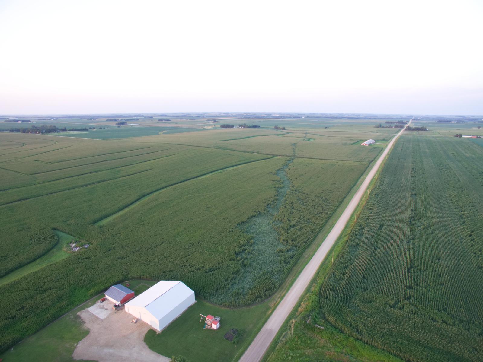
| Tornado track 4 SSW of Saratoga, IA (Courtesy of Matt Benz and Elizabeth Baethke) |
Tornado track 4 SSW of Saratoga, IA (Courtesy of Matt Benz and Elizabeth Baethke) |
Tornado track 4 SSW of Saratoga, IA (Courtesy of Matt Benz and Elizabeth Baethke) |
Tornado track 4 SSW of Saratoga, IA (Courtesy of Matt Benz and Elizabeth Baethke) |
|
|
|
|
| Storm damage near Fort Atkinson, IA (NWS Survey) |
Storm damage near Fort Atkinson, IA (NWS Survey) |
Storm damage near Fort Atkinson, IA (NWS Survey) |
Damaged buildings in Prairie du Chien, WI (NWS Survey) |
 |
 |
 |
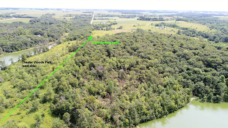 |
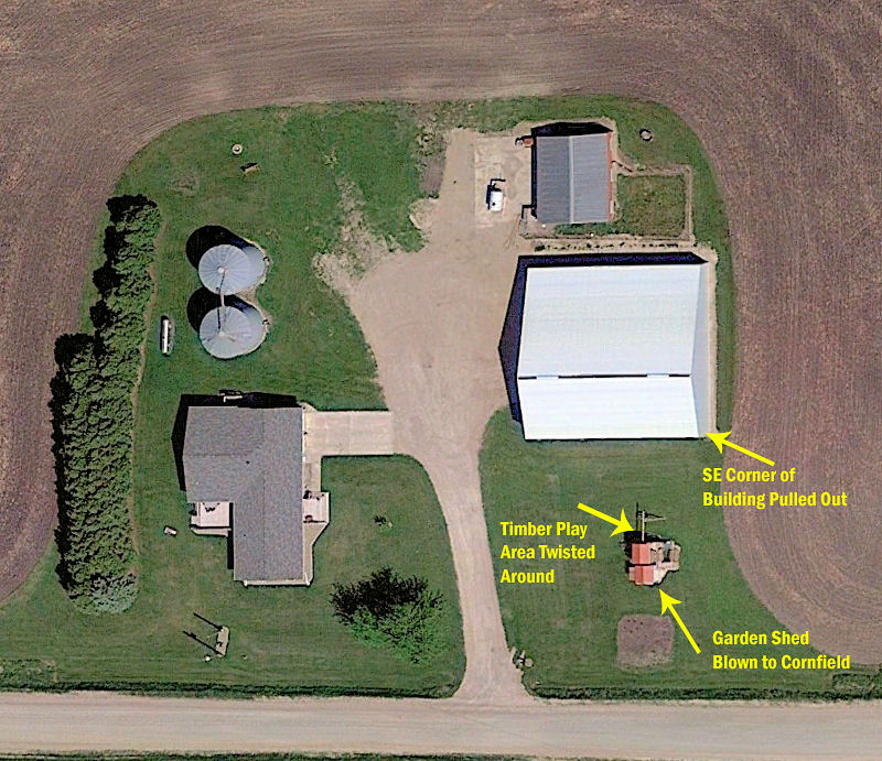
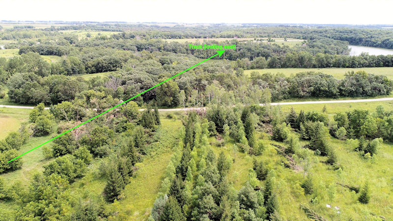
| Chester, MN tornado track through Chester Woods Park (NWS La Crosse) |
Chester, MN tornado damage through Chester Woods Park via drone ​(Courtesy Mike Pruett, mltgroup) |
Chester, MN tornado track through Chester Woods Park via drone ​(Courtesy Mike Pruett, mltgroup) |
Chester, MN tornado track end in Chester Woods Park via drone ​(Courtesy Mike Pruett, mltgroup) |
 |
 |
 |
 |
| Ontario, WI Flooding (Photo by Greg Lawton) |
Ontario, WI Flooding (Photo by Greg Lawton) |
Ontario, WI Flooding (Photo by Greg Lawton) |
La Farge, WI Flooding (Photo by Greg Lawton) |
 |
 |
| Debris clogging culvert on Hwy 33 in Shelby, WI (Photo by David Lawrence) |
Record high levels on the La Crosse River flood the Marsh River Trail under 2-3 feet of water (Photo by David Lawrence) |
Radar:
|
 |
 |
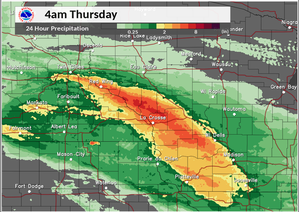 |
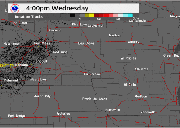
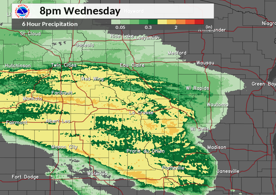
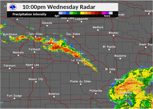
| July 19: Afternoon wind storms | July 19: Afternoon radar rotational tracks | July 19: Radar rainfall estimates through 8 pm | July 19-20: Radar rainfall estimate totals |
 |
 |
 |
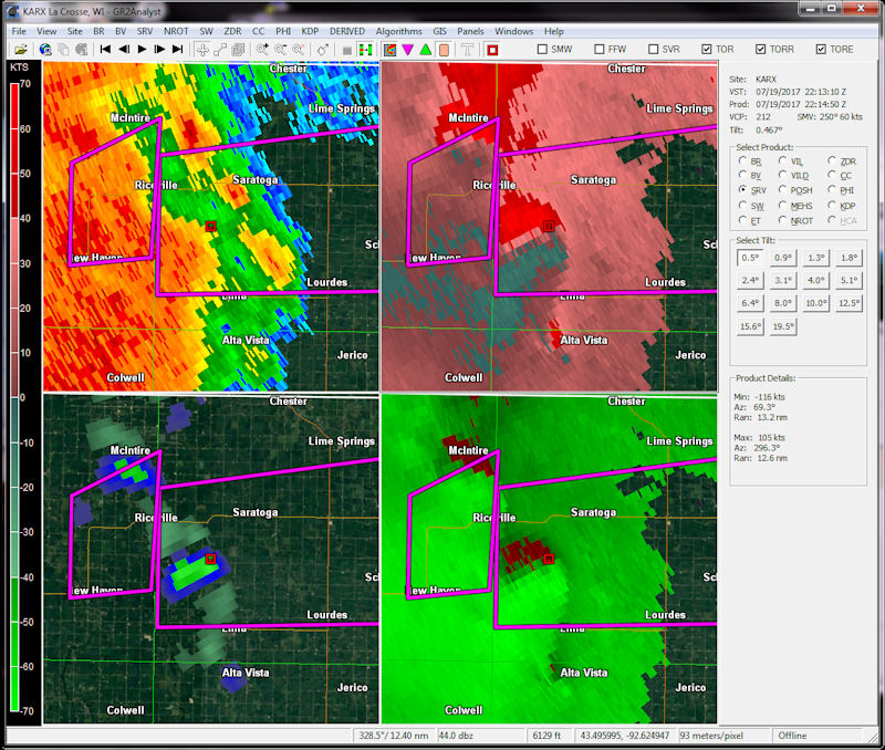 |
| July 20: Overnight radar loop | Saratoga, Iowa reflectivity at 5:15 pm, time of tornado. | Saratoga, Iowa velocity at 5:15 pm, time of tornado. | Saratoga, Iowa radar 4-panel of reflectivity (UL), storm-relative velocity (UR), velocity (LR) and rotation (LL) at 5:15 pm, time of tornado. Tornado location indicated with a square. |
Storm Reports
PRELIMINARY LOCAL STORM REPORT...SUMMARY
NATIONAL WEATHER SERVICE LA CROSSE WI
948 PM CDT WED JUL 19 2017

..TIME...   ...EVENT...      ...CITY LOCATION...     ...LAT.LON...
..DATE...   ....MAG....      ..COUNTY LOCATION..ST.. ...SOURCE....
            ..REMARKS..

0430 PM     TSTM WND DMG     2 N CLAREMONT           44.08N 93.00W
07/19/2017                   DODGE              MN   PUBLIC

            DAMAGE TO TURKEY FARM AND POWER LINES. TIME
            AND LOCATION ESTIMATED BASED ON RADAR.

0435 PM     TSTM WND DMG     2 NE CLAREMONT          44.07N 92.97W
07/19/2017                   DODGE              MN   EMERGENCY MNGR

            BUILDING DAMAGE REPORTED.

0435 PM     TSTM WND DMG     CLAREMONT               44.04N 93.00W
07/19/2017                   DODGE              MN   EMERGENCY MNGR


0435 PM     TSTM WND DMG     3 NE CLAREMONT          44.08N 92.95W
07/19/2017                   DODGE              MN   STORM CHASER

            TREES UPROOTED AND ROOF BLOWN OFF OF
            BUILDING. TIME ESTIMATED BASED ON RADAR.

0435 PM     TSTM WND GST     CLAREMONT               44.04N 93.00W
07/19/2017  E65 MPH          DODGE              MN   TRAINED SPOTTER

            POWER OUT.

0453 PM     TSTM WND GST     2 S NORA SPRINGS        43.12N 93.01W
07/19/2017  E65 MPH          FLOYD              IA   FIRE DEPT/RESCUE


0453 PM     TSTM WND GST     3 NW ROCHESTER          44.04N 92.52W
07/19/2017  M45 MPH          OLMSTED            MN   EMERGENCY MNGR


0453 PM     TSTM WND GST     3 N NORA SPRINGS        43.19N 93.01W
07/19/2017  E65 MPH          FLOYD              IA   FIRE DEPT/RESCUE


0456 PM     TSTM WND GST     RUDD                    43.13N 92.90W
07/19/2017  E65 MPH          FLOYD              IA   FIRE DEPT/RESCUE


0457 PM     TSTM WND GST     OSAGE                   43.28N 92.81W
07/19/2017  E70 MPH          MITCHELL           IA   TRAINED SPOTTER


0459 PM     TSTM WND DMG     OSAGE                   43.29N 92.81W
07/19/2017                   MITCHELL           IA   STORM CHASER

            WIDESPREAD TREE DAMAGE REPORTED. 6 TO 8 INCH
            DIAMETER TREES DOWN. ESTIMATED 70 TO 80 MPH
            WINDS. TIME ESTIMATED BASED ON RADAR.

0500 PM     TSTM WND GST     2 NE ROCHESTER          44.03N 92.45W
07/19/2017  E60 MPH          OLMSTED            MN   EMERGENCY MNGR


0500 PM     TSTM WND DMG     OSAGE                   43.28N 92.81W
07/19/2017                   MITCHELL           IA   TRAINED SPOTTER

            TREE DAMAGE REPORTED IN OSAGE. ESTIMATED
            WIND GUSTS OF 70 MPH.

0500 PM     TSTM WND DMG     NORA SPRINGS            43.15N 93.00W
07/19/2017                   FLOYD              IA   TRAINED SPOTTER

            NUMEROUS TREES DOWN IN NORA SPRINGS.

0500 PM     TSTM WND DMG     3 ENE MITCHELL          43.34N 92.81W
07/19/2017                   MITCHELL           IA   TRAINED SPOTTER

            HEALTHY 5-6" DIAMETER TREE SNAPPED AT BASE,
            DOWNED POWER LINES. TIME ESTIMATED FROM
            RADAR.

0500 PM     TSTM WND DMG     1 NE NORA SPRINGS       43.15N 93.00W
07/19/2017                   FLOYD              IA   TRAINED SPOTTER

            NUMEROUS TREES DOWN IN NORA SPRINGS.

0501 PM     TSTM WND GST     OSAGE                   43.28N 92.81W
07/19/2017  E70 MPH          MITCHELL           IA   TRAINED SPOTTER

            MULTIPLE TREES DOWN.

0507 PM     TSTM WND GST     CHARLES CITY            43.07N 92.68W
07/19/2017  E60 MPH          FLOYD              IA   FIRE DEPT/RESCUE


0512 PM     TSTM WND GST     COLWELL                 43.16N 92.59W
07/19/2017  M62 MPH          FLOYD              IA   CO-OP OBSERVER

            TREE BRANCHES DOWN.

0520 PM     TSTM WND GST     NEW HAMPTON             43.06N 92.31W
07/19/2017  E66 MPH          CHICKASAW          IA   BROADCAST MEDIA

            REPORTED FROM SCHOOLNET SITE IN TOWN.

0520 PM     TSTM WND GST     ALTA VISTA              43.20N 92.42W
07/19/2017  E70 MPH          CHICKASAW          IA   TRAINED SPOTTER

            WIDESPREAD TREE DAMAGE, ONE TREE LAYING ON
            POWER LINES.

0521 PM     FLOOD            ROCHESTER               44.01N 92.48W
07/19/2017                   OLMSTED            MN   AMATEUR RADIO

            STREET FLOODING NEAR ST MARYS.


0527 PM     TSTM WND DMG     3 ENE NEW HAMPTON       43.08N 92.26W
07/19/2017                   CHICKASAW          IA   BROADCAST MEDIA

            POWER LINES DOWN ALONG / NEAR HIGHWAY 24.


0529 PM     TSTM WND GST     1 NE CARIMONA           43.67N 92.14W
07/19/2017  M50 MPH          FILLMORE           MN   EMERGENCY MNGR

            AT FILLMORE CO AIRPORT.


0530 PM     TSTM WND DMG     SAINT CHARLES           43.97N 92.06W
07/19/2017                   WINONA             MN   EMERGENCY MNGR

            POWER LINES DOWN.


0535 PM     TORNADO          2 WSW FORT ATKINSON     43.13N 91.98W
07/19/2017                   WINNESHIEK         IA   LAW ENFORCEMENT

            DELAYED REPORT OF A TORNADO BETWEEN JACKSON
            JUNCTION AND FORT ATKINSON. TIME ESTIMATED
            FROM RADAR.

0535 PM     TSTM WND DMG     WAUCOMA                 43.06N 92.03W
07/19/2017                   FAYETTE            IA   TRAINED SPOTTER

            TREES BLOWN DOWN.


0538 PM     TSTM WND DMG     1 WNW BETHANY           44.03N 91.94W
07/19/2017                   WINONA             MN   EMERGENCY MNGR

            TREES DOWN NEAR HIGHWAY 14 AND COUNTY ROAD
            33.

0538 PM     TSTM WND GST     1 S HARMONY             43.54N 92.01W
07/19/2017  M53 MPH          FILLMORE           MN   FIRE DEPT/RESCUE


0540 PM     TSTM WND DMG     SPILLVILLE              43.20N 91.95W
07/19/2017                   WINNESHIEK         IA   EMERGENCY MNGR

            NUMEROUS TREES DOWN IN SPILLVILLE. TIME
            ESTIMATED FROM RADAR.


0541 PM     TSTM WND DMG     1 W ELDORADO            43.05N 91.85W
07/19/2017                   FAYETTE            IA   911 CALL CENTER

            TREES BLOWN DOWN.


0547 PM     TSTM WND DMG     CRESCO                  43.37N 92.12W
07/19/2017                   HOWARD             IA   LAW ENFORCEMENT

            POWER LINES DOWN ACROSS THE TOWN OF CRESCO.


0549 PM     TSTM WND DMG     CLERMONT                43.00N 91.65W
07/19/2017                   FAYETTE            IA   911 CALL CENTER

            TREES DOWN.


0552 PM     TSTM WND DMG     RIDGEWAY                43.30N 91.99W
07/19/2017                   WINNESHIEK         IA   TRAINED SPOTTER

            2 FT DIAMETER TREES DOWN.


0603 PM     TSTM WND DMG     MONONA                  43.05N 91.39W
07/19/2017                   CLAYTON            IA   LAW ENFORCEMENT

            LOTS OF TREES AND POWER LINES DOWN. CORN
            ALSO IMPACTED. DAMAGE CONTINUED TOWARD
            MCGREGOR.

0605 PM     TSTM WND GST     2 NNW FAYETTE           42.87N 91.82W
07/19/2017  M50 MPH          FAYETTE            IA   AMATEUR RADIO

            SOME BRANCHES DOWN.


0612 PM     TSTM WND DMG     WAUKON                  43.27N 91.48W
07/19/2017                   ALLAMAKEE          IA   PUBLIC

            PART OF A ROOF REMOVED FROM AN OUTBUILDING
            AND CORN PUSHED OVER. TIME ESTIMATED BASED
            ON RADAR. RECEIVED VIA SOCIAL MEDIA.


0614 PM     TSTM WND DMG     4 SSE WAUKON            43.22N 91.45W
07/19/2017                   ALLAMAKEE          IA   STORM CHASER

            CORN BLOWN DOWN. SHED DAMAGE. TREE BLOWN ON
            HOUSE.

0615 PM     TSTM WND DMG     6 ESE DECORAH           43.27N 91.68W
07/19/2017                   WINNESHIEK         IA   PUBLIC

            TREES SNAPPED OR UPROOTED.

0620 PM     TSTM WND DMG     2 SE PRAIRIE DU CHIEN   43.02N 91.11W
07/19/2017                   CRAWFORD           WI   BROADCAST MEDIA

            HANGER DAMAGED AT AIRPORT. TIME ESTIMATED.

0620 PM     TSTM WND GST     1 NE PRAIRIE DU CHIEN   43.05N 91.13W
07/19/2017  E65 MPH          CRAWFORD           WI   TRAINED SPOTTER

            TREES DOWN AND CORN DAMAGE JUST EAST OF
            PRAIRIE DU CHIEN.

0623 PM     TSTM WND GST     3 NNW EDGEWOOD          42.68N 91.42W
07/19/2017  M52 MPH          CLAYTON            IA   FIRE DEPT/RESCUE

            AT FIRE HALL IN EDGEWOOD.


0625 PM     TSTM WND GST     PATCH GROVE             42.94N 90.97W
07/19/2017  E70 MPH          GRANT              WI   EMERGENCY MNGR


0625 PM     TSTM WND GST     1 SSE DE SOTO           43.41N 91.19W
07/19/2017  E60 MPH          CRAWFORD           WI   TRAINED SPOTTER


0627 PM     TSTM WND DMG     3 NE MOUNT HOPE         43.00N 90.82W
07/19/2017                   GRANT              WI   TRAINED SPOTTER

            SHED DAMAGED. 4-WHEELER BLOWN OVER FROM
            EXTREME WINDS.

0628 PM     TSTM WND GST     1 NNE FRENCH ISLAND     43.88N 91.26W
07/19/2017  M54 MPH          LA CROSSE          WI   ASOS

            LSE ASOS MEASURED A 54 MPH WIND GUST.

0634 PM     TSTM WND DMG     STODDARD                43.66N 91.22W
07/19/2017                   VERNON             WI   TRAINED SPOTTER

            LARGE BRANCHES DOWN IN VILLAGE. TIME
            ESTIMATED.

0641 PM     FLOOD            1 SW LA CROSSE          43.81N 91.25W
07/19/2017                   LA CROSSE          WI   AMATEUR RADIO

            STREET FLOODING ALONG WITH SMALL BRANCHES
            DOWN.

0641 PM     TSTM WND DMG     5 S LA CROSSE           43.75N 91.25W
07/19/2017                   LA CROSSE          WI   TRAINED SPOTTER

            LARGE BRANCHES DOWN ALONG SOUTH AVE.


0645 PM     TSTM WND DMG     5 NE STODDARD           43.72N 91.16W
07/19/2017                   VERNON             WI   TRAINED SPOTTER

            TREE LIMBS DOWN. SIZE WAS UP TO 6 INCHES IN
            DIAMETER. NUMEROUS LIMBS DOWN.

0647 PM     TSTM WND GST     3 NE MOUNT HOPE         43.00N 90.82W
07/19/2017  E60 MPH          GRANT              WI   PUBLIC

            TREES DAMAGED.

0649 PM     TSTM WND GST     LANCASTER               42.85N 90.71W
07/19/2017  E70 MPH          GRANT              WI   EMERGENCY MNGR

            TREES/POWERLINES DOWN. SIGNIFICANT DAMAGE.
            POWER OUTAGES.

0650 PM     TSTM WND GST     PLATTEVILLE             42.74N 90.48W
07/19/2017  E70 MPH          GRANT              WI   TRAINED SPOTTER


0650 PM     TSTM WND GST     5 ENE ELLENBORO         42.81N 90.52W
07/19/2017  M61 MPH          GRANT              WI   TRAINED SPOTTER


0651 PM     TSTM WND GST     1 SSE LA CROSSE         43.81N 91.22W
07/19/2017  E60 MPH          LA CROSSE          WI   NWS EMPLOYEE

            BRANCHES DOWN.

0651 PM     TSTM WND DMG     READSTOWN               43.45N 90.76W
07/19/2017                   VERNON             WI   911 CALL CENTER

            TREES AND POWER LINES DOWN.

0651 PM     TSTM WND GST     2 SSE LA CROSSE         43.81N 91.22W
07/19/2017  E60 MPH          LA CROSSE          WI   NWS EMPLOYEE

            BRANCHES DOWN.

0653 PM     TSTM WND GST     2 ESE LA CROSSE         43.81N 91.19W
07/19/2017  M46 MPH          LA CROSSE          WI   OFFICIAL NWS OBS

            AT NWS LA CROSSE.

0655 PM     TSTM WND GST     4 NW PLATTEVILLE        42.78N 90.53W
07/19/2017  M66 MPH          GRANT              WI   TRAINED SPOTTER

            TREE DAMAGE, INCLUDING AN OAK FALLING ON
            POWER LINES. TIME ESTIMATED FROM RADAR.


0700 PM     TSTM WND DMG     1 WSW BLUE RIVER        43.18N 90.59W
07/19/2017                   GRANT              WI   EMERGENCY MNGR

            TREES AND POWER LINES DOWN.

0711 PM     FLOOD            1 SW LA CROSSE          43.81N 91.25W
07/19/2017                   LA CROSSE          WI   NWS EMPLOYEE

            STREET FLOODING IN LA CROSSE. SOME PLACES A
            FOOT DEEP.

0713 PM     TSTM WND DMG     LA FARGE                43.58N 90.64W
07/19/2017                   VERNON             WI   911 CALL CENTER

            TREES AND POWER LINES DOWN.


0725 PM     TSTM WND DMG     1 SSW GOTHAM            43.21N 90.30W
07/19/2017                   RICHLAND           WI   AMATEUR RADIO

            TREES AND POWER LINES DOWN.

0759 PM     TSTM WND DMG     RICHLAND CENTER         43.34N 90.38W
07/19/2017                   RICHLAND           WI   TRAINED SPOTTER

            LARGE BRANCHES FALLING IN TOWN.

0806 PM     HEAVY RAIN       1 ENE CATARACT          44.09N 90.83W
07/19/2017  M1.56 INCH       MONROE             WI   TRAINED SPOTTER
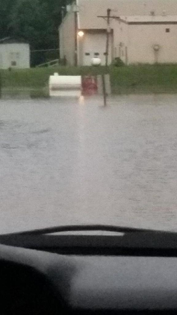
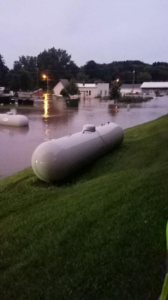
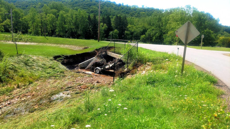
Flooding Reports
PRELIMINARY LOCAL STORM REPORT...SUMMARY
NATIONAL WEATHER SERVICE LA CROSSE WI
1021 AM CDT THU JUL 20 2017

..TIME...   ...EVENT...      ...CITY LOCATION...     ...LAT.LON...
..DATE...   ....MAG....      ..COUNTY LOCATION..ST.. ...SOURCE....
            ..REMARKS..

0921 AM     HEAVY RAIN       1 SE LA CROSSE          43.81N 91.22W
07/20/2017  M6.00 INCH       LA CROSSE          WI   PUBLIC


0921 AM     HEAVY RAIN       1 SSE LA CROSSE         43.81N 91.22W
07/20/2017  M6.00 INCH       LA CROSSE          WI   PUBLIC


0900 AM     HEAVY RAIN       3 NW WABASHA            44.41N 92.09W
07/20/2017  M5.10 INCH       WABASHA            MN   PUBLIC


0827 AM     HEAVY RAIN       4 SSW CASHTON           43.70N 90.82W
07/20/2017  M5.50 INCH       VERNON             WI   PUBLIC


0823 AM     FLOOD            BLAIR                   44.30N 91.23W
07/20/2017                   TREMPEALEAU        WI   LAW ENFORCEMENT

            REPORTS OF 5 TO 6 FEET OF WATER IN BASEMENT
            IN A FEW HOMES.

0823 AM     FLOOD            GALESVILLE              44.08N 91.36W
07/20/2017                   TREMPEALEAU        WI   LAW ENFORCEMENT

            SOME HOMES HAVE 5 TO 6 FEET OF WATER IN THE
            BASEMENT.

0808 AM     FLASH FLOOD      SPARTA                  43.94N 90.81W
07/20/2017                   MONROE             WI   LAW ENFORCEMENT

            WATER BEGINNING TO GO OVER A FEW ROADS IN
            SPARTA.

0800 AM     FLOOD            ONTARIO                 43.72N 90.59W
07/20/2017                   VERNON             WI   PUBLIC

            TOWN UNDER WATER DUE TO FLOODING ALONG
            KICKAPOO RIVER...REFLECTED IN PICTURES
            RECEIVED AND FROM LAW ENFORCEMENT REPORTS.

0800 AM     HEAVY RAIN       NELSON                  44.42N 92.00W
07/20/2017  M7.00 INCH       BUFFALO            WI   PUBLIC


0757 AM     FLOOD            4 S BARRE MILLS         43.78N 91.12W
07/20/2017                   LA CROSSE          WI   LAW ENFORCEMENT

            BREIDEL COULEE ROAD WASHED OUT WHERE IT
            CROSSES MORMON CREEK. BRIDGE IS INTACT BUT
            WASHED OUT ON BOTH SIDES.

0754 AM     HEAVY RAIN       HARPERS FERRY           43.20N 91.15W
07/20/2017  M2.24 INCH       ALLAMAKEE          IA   PUBLIC


0743 AM     FLASH FLOOD      YUBA                    43.54N 90.43W
07/20/2017                   RICHLAND           WI   LAW ENFORCEMENT

            SANDBAGGING GOING ON IN YUBA.

0743 AM     FLASH FLOOD      RICHLAND CENTER         43.34N 90.38W
07/20/2017                   RICHLAND           WI   LAW ENFORCEMENT

            PINE RIVER HAS RISEN OUT OF ITS BANKS.

0715 AM     HEAVY RAIN       3 SW MELROSE            44.10N 91.04W
07/20/2017  M5.60 INCH       JACKSON            WI   TRAINED SPOTTER


0701 AM     HEAVY RAIN       ARCADIA                 44.25N 91.49W
07/20/2017  M7.44 INCH       TREMPEALEAU        WI   PUBLIC


0700 AM     HEAVY RAIN       1 NW MOUNT ZION         43.27N 90.75W
07/20/2017  M3.18 INCH       CRAWFORD           WI   PUBLIC


0635 AM     FLASH FLOOD      2 S ROCKBRIDGE          43.42N 90.36W
07/20/2017                   RICHLAND           WI   DEPT OF HIGHWAYS

            STATE HIGHWAY 80 IS CLOSED AT COUNTY ROAD D
            BECAUSE OF FLOODING ALONG THE PINE RIVER.

0635 AM     HEAVY RAIN       HILLSBORO               43.65N 90.34W
07/20/2017  E7.00 INCH       VERNON             WI   PUBLIC

            RELAYED VIA WKBT.

0630 AM     HEAVY RAIN       WABASHA                 44.37N 92.05W
07/20/2017  E6.00 INCH       WABASHA            MN   PUBLIC

            GAUGE WAS NEARLY FULL AND ABOVE MARKINGS.

0625 AM     HEAVY RAIN       DODGE                   44.13N 91.55W
07/20/2017  E6.00 INCH       TREMPEALEAU        WI   PUBLIC

            RELAYED VIA WKBT.

0621 AM     HEAVY RAIN       1 N BANGOR              43.90N 90.99W
07/20/2017  M4.50 INCH       LA CROSSE          WI   PUBLIC


0615 AM     HEAVY RAIN       1 WNW PLATTEVILLE       42.74N 90.49W
07/20/2017  M2.60 INCH       GRANT              WI   TRAINED SPOTTER


0602 AM     HEAVY RAIN       3 WNW BOSCOBEL          43.16N 90.76W
07/20/2017  M6.25 INCH       CRAWFORD           WI   PUBLIC

            MEASURED IN MARIETTA.

0539 AM     FLASH FLOOD      2 ESE ONALASKA          43.88N 91.17W
07/20/2017                   LA CROSSE          WI   PUBLIC

            N. KINNEY COULEE ROAD CLOSED DUE TO WASHOUTS
            AND DOWNED TREES. RELAYED VIA BROADCAST
            MEDIA.

0538 AM     FLASH FLOOD      BLAIR                   44.30N 91.23W
07/20/2017                   TREMPEALEAU        WI   LAW ENFORCEMENT

            HIGHWAY 95 BETWEEN BLAIR AND THE JACKSON
            COUNTY LINE CLOSED.

0537 AM     FLASH FLOOD      2 WSW ROCKLAND          43.90N 90.95W
07/20/2017                   LA CROSSE          WI   PUBLIC

            COUNTY ROAD U BETWEEN BANGOR AND ROCKLAND
            CLOSED DUE TO FLOODING. RELAYED VIA
            BROADCAST MEDIA.

0500 AM     HEAVY RAIN       3 NNW FRENCHVILLE       44.19N 91.35W
07/20/2017  M6.24 INCH       TREMPEALEAU        WI   PUBLIC


0447 AM     FLASH FLOOD      3 NNW SAINT JOSEPH      43.82N 91.06W
07/20/2017                   LA CROSSE          WI   LAW ENFORCEMENT

            TOWN OF SHELBY FIRE DEPARTMENT WAS
            EVACUATING PEOPLE FROM HOMES ALONG COUNTY M
            IN GREENFIELD, INCLUDING HAVING TO USE A
            BOAT.

0430 AM     FLASH FLOOD      4 S TUNNEL CITY         43.95N 90.56W
07/20/2017                   MONROE             WI   LAW ENFORCEMENT

            MUDSLIDE BLOCKING HIGHWAY 16 IN THE JACKSON
            PASS AREA.

0426 AM     FLASH FLOOD      3 WNW LA CRESCENT       43.85N 91.36W
07/20/2017                   WINONA             MN   LAW ENFORCEMENT

            MUDSLIDE AT BURNS VALLEY ROAD NEAR THE PINE
            CREEK GOLF COURSE.

0400 AM     FLASH FLOOD      ONTARIO                 43.72N 90.59W
07/20/2017                   VERNON             WI   LAW ENFORCEMENT

            MAJOR FLOODING IN ONTARIO. INTERSECTION OF
            HIGHWAY 33 AND 131 CLOSED.

0326 AM     FLASH FLOOD      ARCADIA                 44.25N 91.49W
07/20/2017                   TREMPEALEAU        WI   BROADCAST MEDIA

            REPORTS OF WATER RESCUES ONGOING IN ARCADIA.
            ALL ROADS INTO ARCADIA CLOSED DUE TO
            FLOODING. RELAYED VIA WKBT.

0326 AM     HEAVY RAIN       1 W WEST SALEM          43.90N 91.10W
07/20/2017  M4.98 INCH       LA CROSSE          WI   NWS EMPLOYEE

            STORM TOTAL SO FAR, STILL RAINING.

0326 AM     FLASH FLOOD      ARCADIA                 44.25N 91.49W
07/20/2017                   TREMPEALEAU        WI   BROADCAST MEDIA

            REPORTS OF WATER RESCUES ONGOING IN ARCADIA.
            ALL ROADS INTO ARCADIA CLOSED DUE TO
            FLOODING. RELAYED VIA WKBT.

0308 AM     HEAVY RAIN       1 SW CATARACT           44.08N 90.85W
07/20/2017  M4.10 INCH       MONROE             WI   PUBLIC

            STORM TOTAL.

0255 AM     FLASH FLOOD      2 NNW ONALASKA          43.92N 91.23W
07/20/2017                   LA CROSSE          WI   LAW ENFORCEMENT

            SAND LAKE ROAD WAS COMPLETELY COVERED BY
            FLOOD WATERS NEAR CEDAR CREEK GOLF COURSE
            AND THE INTERSECTION OF 10TH AVENUE AND
            QUINCY STREET IN ONALASKA WAS FLOODED.

0246 AM     FLASH FLOOD      2 S LA CROSSE           43.80N 91.24W
07/20/2017                   LA CROSSE          WI   LAW ENFORCEMENT

            SEVERAL STREETS UNDERWATER IN LA CROSSE.

0155 AM     FLASH FLOOD      6 WSW BLAIR             44.26N 91.35W
07/20/2017                   TREMPEALEAU        WI   DEPT OF HIGHWAYS

            ALL LANES OF STATE HIGHWAY 95 CLOSED BETWEEN
            ARCADIA AND BLAIR DUE TO FLOOD WATERS.

0120 AM     FLASH FLOOD      1 NW FOUNTAIN CITY      44.13N 91.72W
07/20/2017                   BUFFALO            WI   LAW ENFORCEMENT

            STANDING WATER NEAR THE KWIK TRIP IN
            FOUNTAIN CITY.

0120 AM     FLASH FLOOD      2 E COCHRANE            44.23N 91.79W
07/20/2017                   BUFFALO            WI   LAW ENFORCEMENT

            COUNTY ROAD O IS UNDER 1 FT OF WATER, AND
            THE ROAD IS COMPLETELY CLOSED.

0119 AM     FLASH FLOOD      4 NE PICKWICK           44.02N 91.55W
07/20/2017                   WINONA             MN   LAW ENFORCEMENT

            MUDSLIDE COVERING SOUTHBOUND LANES OF US
            HIGHWAY 61 AT COUNTY HIGHWAY 15.

0100 AM     HEAVY RAIN       1 W WEST SALEM          43.90N 91.10W
07/20/2017  M3.43 INCH       LA CROSSE          WI   NWS EMPLOYEE

            STORM TOTAL.

1253 AM     FLASH FLOOD      MINNEISKA               44.19N 91.87W
07/20/2017                   WINONA             MN   LAW ENFORCEMENT

            MUDSLIDE ON US HIGHWAY 61 NEAR MINNEISKA.

1231 AM     FLASH FLOOD      ARCADIA                 44.25N 91.50W
07/20/2017                   TREMPEALEAU        WI   LAW ENFORCEMENT

            FLASH FLOODING IN ARCADIA. NUMEROUS ROADS IN
            TREMPEALEAU COUNTY UNDER 1 TO 2 FEET OF
            WATER, INCLUDING PORTIONS OF US HIGHWAY 53,
            STATE HIGHWAY 93, AND COUNTY HIGHWAYS D AND
            T.

1145 PM     HEAVY RAIN       WABASHA                 44.37N 92.05W
07/19/2017  E3.50 INCH       WABASHA            MN   LAW ENFORCEMENT

            ESTIMATED STORM TOTAL RAINFALL OF 3.50 TO
            3.75 INCHES.

1135 PM     TSTM WND DMG     1 SSE ALMA              44.31N 91.91W
07/19/2017                   BUFFALO            WI   LAW ENFORCEMENT

            POWER LINE DOWN. TIME ESTIMATED FROM RADAR.

1042 PM     FLASH FLOOD      4 NNE ALMA              44.37N 91.89W
07/19/2017                   BUFFALO            WI   LAW ENFORCEMENT

            REPORT OF A MUDSLIDE ON HIGHWAY 37. NORTH OF
            ALMA.
Rain Reports
...24 Hour Rainfall Reports...

Location                     Amount    Time/Date       Lat/Lon

...Iowa...

...Allamakee County...
Harpers Ferry                2.24 in   0754 AM 07/20   43.20N/91.15W
4 ENE Watson                 0.83 in   0745 AM 07/20   43.11N/91.26W
3 S Dorchester               0.75 in   0800 AM 07/20   43.42N/91.51W

...Chickasaw County...
Ionia 2W                     0.66 in   0745 AM 07/20   43.03N/92.50W
New Hampton                  0.57 in   0700 AM 07/20   43.06N/92.31W
New Hampton                  0.42 in   0700 AM 07/20   43.06N/92.32W

...Clayton County...
Edgewood                     1.10 in   0530 AM 07/20   42.65N/91.40W
Guttenberg Dam 10            1.09 in   0800 AM 07/20   42.78N/91.10W
Garber                       0.83 in   0815 AM 07/20   42.74N/91.26W
Littleport                   0.79 in   0745 AM 07/20   42.75N/91.37W
Volga 1NE                    0.75 in   0600 AM 07/20   42.81N/91.52W
Elkader 5NW                  0.69 in   0800 AM 07/20   42.91N/91.47W
Marquette-Bloody Run Creek   0.36 in   0800 AM 07/20   43.04N/91.21W
Monona WWTP                  0.32 in   0700 AM 07/20   43.04N/91.40W

...Fayette County...
Fayette                      0.82 in   0700 AM 07/20   42.85N/91.82W
Fayette-CWOP                 0.68 in   0830 AM 07/20   42.84N/91.80W
1 ENE Alpha                  0.56 in   0700 AM 07/20   43.01N/92.03W
Oelwein Municipal Airport    0.47 in   0655 AM 07/20   42.68N/91.97W
Waucoma 1WNW                 0.43 in   0700 AM 07/20   43.06N/92.05W
Eldorado                     0.36 in   0745 AM 07/20   43.05N/91.81W

...Floyd County...
Charles City                 0.73 in   0700 AM 07/20   43.06N/92.67W
Nashua 2sw                   0.72 in   0600 AM 07/20   42.94N/92.57W
Nora Springs 2.4 SSE         0.68 in   0700 AM 07/20   43.11N/92.99W
Charles City-Cedar River     0.67 in   0830 AM 07/20   43.06N/92.67W
Rockford-Shell Rock Rvr      0.51 in   0745 AM 07/20   43.01N/92.93W
Charles City Airport         0.51 in   0655 AM 07/20   43.07N/92.61W

...Howard County...
3 NE Riceville               1.12 in   0829 AM 07/20   43.40N/92.50W
Cresco 1NE                   0.50 in   0700 AM 07/20   43.39N/92.09W

...Mitchell County...
Osage                        0.68 in   0700 AM 07/20   43.28N/92.81W
St Ansgar                    0.63 in   0630 AM 07/20   43.38N/92.92W
Osage                        0.48 in   0745 AM 07/20   43.28N/92.85W

...Winneshiek County...
Decorah Municipal Airport    0.96 in   0655 AM 07/20   43.28N/91.74W
7 ENE Decorah                0.61 in   0743 AM 07/20   43.34N/91.64W
5 ESE Decorah                0.49 in   0700 AM 07/20   43.26N/91.70W

...Minnesota...

...Dodge County...
Mantorville                  2.95 in   0700 AM 07/20   44.07N/92.77W
2 NE Kasson                  2.44 in   0530 AM 07/20   44.05N/92.72W
Hayfield                     0.96 in   0600 AM 07/20   43.89N/92.85W

...Fillmore County...
1 SSE Pilot Mound            0.89 in   0700 AM 07/20   43.79N/92.03W
Preston                      0.84 in   0808 AM 07/20   43.67N/92.07W
Pilot Mound-Root River       0.76 in   0800 AM 07/20   43.78N/92.03W
Mabel                        0.58 in   0630 AM 07/20   43.52N/91.76W
Spring Valley 3sw            0.55 in   0700 AM 07/20   43.66N/92.41W
3 NE Preston                 0.53 in   0700 AM 07/20   43.71N/92.05W
Lanesboro 2NE                0.49 in   0800 AM 07/20   43.73N/91.94W
Spring Valley 3E             0.49 in   0700 AM 07/20   43.68N/92.33W
Fillmore                     0.45 in   0830 AM 07/20   43.76N/92.27W
Lanesboro-Root River         0.39 in   0830 AM 07/20   43.72N/91.98W
Preston Airport              0.14 in   0652 AM 07/20   43.68N/92.18W

...Houston County...
La Crescent 1N               6.05 in   0730 AM 07/20
La Crescent                  5.43 in   0730 AM 07/20   43.84N/91.31W
Hokah WWTP                   3.89 in   0700 AM 07/20   43.76N/91.35W
Mound Prairie                2.73 in   0745 AM 07/20   43.78N/91.45W
Houston                      2.37 in   0745 AM 07/20   43.77N/91.57W
Caledonia                    1.90 in   0700 AM 07/20   43.63N/91.50W
4 NW Eitzen                  1.23 in   0800 AM 07/20   43.56N/91.51W

...Mower County...
Austin Municipal Airport     0.99 in   0654 AM 07/20   43.66N/92.93W
Austin 2NE-Dobbins Creek     0.98 in   0830 AM 07/20   43.67N/92.95W
Austin 3 NW - Turtle Creek   0.83 in   0830 AM 07/20   43.65N/92.98W
Austin 3S                    0.64 in   0800 AM 07/20   43.64N/92.97W

...Olmsted County...

3 N Rochester                2.51 in   0615 AM 07/20   44.06N/92.47W
2 NNW Rochester              2.47 in   0700 AM 07/20   44.05N/92.49W
2 NE Rochester               2.40 in   0650 AM 07/20   44.04N/92.45W
Eyota 2NE                    2.40 in   0730 AM 07/20   44.01N/92.20W
Eyota 8SW                    2.40 in   0730 AM 07/20
4 ESE Douglas                2.38 in   0642 AM 07/20   44.08N/92.51W
2 ENE Rochester              2.28 in   0830 AM 07/20   44.03N/92.43W
4 NNW Rochester              2.15 in   0700 AM 07/20   44.07N/92.49W
Dover                        2.06 in   0800 AM 07/20   43.97N/92.12W
3 ESE Douglas                1.99 in   0835 AM 07/20   44.09N/92.51W
Rochester-Cascade Creek      1.95 in   0830 AM 07/20   44.03N/92.47W
1 W Chester                  1.87 in   0620 AM 07/20   44.00N/92.38W
Rochester                    1.86 in   0624 AM 07/20   44.01N/92.47W
2 NE Rochester               1.84 in   0826 AM 07/20   44.04N/92.44W
Byron 4 North                1.79 in   0700 AM 07/20   44.09N/92.64W
Elgin 5SE                    1.72 in   0730 AM 07/20   44.01N/92.11W
Rochester-Beltline           1.66 in   0830 AM 07/20   44.01N/92.47W
Rochester-Beltline Bear Cree 1.66 in   0830 AM 07/20   44.01N/92.45W
Elgin 2ssw                   1.65 in   0700 AM 07/20   44.10N/92.27W
2 SE Douglas                 1.60 in   0836 AM 07/20   44.08N/92.55W
4 WSW Rochester              1.56 in   0600 AM 07/20   43.98N/92.56W
Byron                        1.55 in   0829 AM 07/20   44.04N/92.64W
2 N Rock Dell                1.55 in   0730 AM 07/20   43.96N/92.63W
Mayo Helipad                 1.48 in   0653 AM 07/20   44.02N/92.48W
Rochester                    1.31 in   0834 AM 07/20   44.01N/92.49W
Rochester Ap 2ne             1.31 in   0700 AM 07/20   43.93N/92.48W
Rochester 3W                 1.26 in   0730 AM 07/20   44.02N/92.53W
Rochester International Airp 1.24 in   0654 AM 07/20   43.91N/92.50W
Byron                        1.22 in   0836 AM 07/20   44.03N/92.66W
Oronoco                      1.08 in   0830 AM 07/20   44.16N/92.54W
3 SW Hammond                 1.05 in   0837 AM 07/20   44.18N/92.41W
Pine Island 1S               1.02 in   0800 AM 07/20   44.19N/92.65W
Oronoco 1W                   0.96 in   0830 AM 07/20   44.17N/92.55W
Elba 4.7 SW                  0.93 in   0700 AM 07/20   44.04N/92.09W

...Wabasha County...
Wabasha                      6.00 in   0630 AM 07/20   44.37N/92.05W
Kellogg-Zumbro River         5.36 in   0800 AM 07/20   44.32N/92.00W
3 NW Wabasha                 5.10 in   0900 AM 07/20   44.41N/92.09W
Wabasha                      5.03 in   0700 AM 07/20   44.38N/92.05W
Reads Landing                4.80 in   0700 AM 07/20
Wabasha 1SE                  4.58 in   0130 AM 07/20
1 SSE Lake City              3.47 in   0800 AM 07/20   44.43N/92.27W
Lake City                    3.12 in   0827 AM 07/20   44.45N/92.27W
Plainview                    1.79 in   0836 AM 07/20   44.17N/92.17W
Mazeppa 3ESE                 1.67 in   0830 AM 07/20   44.26N/92.49W
3 SW Zumbro Falls            1.67 in   0700 AM 07/20   44.24N/92.46W
2 NNW Zumbro Falls           1.56 in   0836 AM 07/20   44.32N/92.44W

...Winona County...
Minnesota City Dam 5         5.11 in   0800 AM 07/20   44.16N/91.81W
La Crescent Dam 7            4.75 in   0800 AM 07/20   43.87N/91.31W
Winona                       4.65 in   0901 AM 07/20   44.05N/91.66W
Dakota                       4.52 in   0815 AM 07/20   43.91N/91.36W
Winona Dam 5A                4.50 in   0800 AM 07/20   44.09N/91.67W
1 ESE Minnesota City         3.55 in   0700 AM 07/20   44.08N/91.73W
Winona Municipal Airport     3.44 in   0652 AM 07/20   44.08N/91.71W
Winona 4SW                   3.38 in   0700 AM 07/20
Stockton                     3.36 in   0713 AM 07/20   44.03N/91.77W
Altura 5w                    2.80 in   0700 AM 07/20   44.06N/92.04W
Whitewater State Park Group  2.70 in   0730 AM 07/20   44.06N/92.05W
Lewiston                     2.69 in   0700 AM 07/20   43.99N/91.87W
Whitewater State Park        2.07 in   0730 AM 07/20   44.05N/92.05W
Beaver-White Water River     1.83 in   0745 AM 07/20   44.15N/92.00W
Elba                         1.45 in   0745 AM 07/20   44.09N/92.03W

...Wisconsin...

...Adams County...
Castle Rock                  1.77 in   0710 AM 07/20   43.87N/89.95W
Petenwell Lake               0.72 in   0700 AM 07/20   44.08N/90.00W
Friendship                   0.61 in   0700 AM 07/20   43.98N/89.83W

...Buffalo County...
Nelson                       7.00 in   0800 AM 07/20   44.42N/92.00W
Alma Dam 4                   6.37 in   0800 AM 07/20   44.33N/91.92W
5 NE Montana                 2.97 in   0700 AM 07/20   44.40N/91.60W

...Clark County...
Neillsville 1W               0.31 in   0815 AM 07/20   44.56N/90.61W
Neillsville 3ese             0.17 in   0600 AM 07/20   44.54N/90.53W

...Crawford County...
3 WNW Boscobel               6.25 in   0602 AM 07/20   43.16N/90.76W
Steuben                      3.89 in   0745 AM 07/20   43.18N/90.86W
Steuben 4SE                  3.49 in   0738 AM 07/20   43.13N/90.84W
1 WNW Mount Zion             3.18 in   0700 AM 07/20   43.26N/90.76W
1 NW Mount Zion              3.18 in   0700 AM 07/20   43.27N/90.75W
Lynxville Dam 9              2.60 in   0600 AM 07/20   43.21N/91.10W
Ferryville                   2.38 in   0656 AM 07/20   43.33N/91.07W
De Soto 1SE                  1.95 in   0600 AM 07/20   43.42N/91.19W
Prairie Du Chien  Airport    0.76 in   0655 AM 07/20   43.02N/91.12W
Prairie Du Chien             0.67 in   0700 AM 07/20   43.05N/91.13W

...Grant County...
Muscoda 6S                   5.25 in   0700 AM 07/20
Boscobel Airport             3.52 in   0653 AM 07/20   43.16N/90.67W
1 ENE Boscobel               3.50 in   0803 AM 07/20   43.15N/90.68W
Muscoda                      2.74 in   0745 AM 07/20   43.20N/90.44W
1 W Platteville              2.62 in   0615 AM 07/20   42.74N/90.49W
Lancaster 4wsw               2.08 in   0745 AM 07/20   42.83N/90.79W
Platteville Municipal Airpor 1.84 in   0655 AM 07/20   42.69N/90.44W
Cuba City                    1.38 in   0800 AM 07/20   42.60N/90.43W

...Jackson County...
3 SW Melrose                 5.60 in   0715 AM 07/20   44.10N/91.04W
Black River Falls Area Airpo 1.57 in   0655 AM 07/20   44.25N/90.86W
Black River Falls-black Rive 1.48 in   0815 AM 07/20   44.28N/90.87W
1 E Black River Falls        1.32 in   0815 AM 07/20   44.30N/90.83W
Mather 3nw                   0.90 in   0700 AM 07/20   44.17N/90.35W

...Juneau County...
Union Center                 5.16 in   0700 AM 07/20   43.68N/90.26W
New Lisbon 4ene              2.57 in   0700 AM 07/20   43.91N/90.07W
Volk Field                   2.21 in   0658 AM 07/20   43.94N/90.25W
Mauston                      1.96 in   0837 AM 07/20   43.80N/90.07W
2 WNW Wisconsin Dells        1.71 in   0840 AM 07/20   43.65N/89.82W
2 N Cloverdale               0.86 in   0810 AM 07/20   44.06N/90.17W
Necedah                      0.83 in   0748 AM 07/20   44.03N/90.08W
Mauston Airport              0.44 in   0655 AM 07/20   43.84N/90.14W

...La Crosse County...
Melrose 8.2 SSW              7.50 in   0800 AM 07/20   44.02N/91.06W
3 W St Joseph                6.62 in   0700 AM 07/20   43.78N/91.10W
La Crosse Weather Office     6.26 in   0600 AM 07/20   43.82N/91.19W
La Crosse south side         6.00 in   0700 AM 07/20
1 SE La Crosse               6.00 in   0921 AM 07/20   43.81N/91.22W
Holmen 2s                    5.83 in   0700 AM 07/20   43.93N/91.25W
1 SW West Salem              5.50 in   0700 AM 07/20   43.88N/91.10W
La Crosse 4NNW               5.44 in   0730 AM 07/20   43.87N/91.27W
West Salem                   5.36 in   0700 AM 07/20   43.90N/91.09W
West Salem 2W                5.30 in   0700 AM 07/20   43.90N/91.12W
La Crosse Regional Airport   5.15 in   0653 AM 07/20   43.88N/91.26W
Bangor                       4.50 in   0621 AM 07/20   43.90N/90.99W

...Monroe County...
Cashton 3NNW                 6.15 in   0730 AM 07/20   43.79N/90.80W
Sparta/Fort McCoy Airport    4.38 in   0655 AM 07/20   43.96N/90.74W
Cataract                     4.35 in   0700 AM 07/20   44.08N/90.85W
Sparta                       4.34 in   0800 AM 07/20   43.94N/90.82W
Fort Mccoy- Stillwell Creek  3.76 in   0715 AM 07/20   44.00N/90.68W
2 E Cataract                 3.35 in   0838 AM 07/20   44.09N/90.79W
Warrens 4WSW                 3.04 in   0700 AM 07/20   44.10N/90.59W
Tomah Ranger Station 2       2.96 in   0800 AM 07/20   43.97N/90.47W
Four Corners                 2.89 in   0700 AM 07/20   44.09N/90.91W

...Richland County...
Richland Center 4N           4.06 in   0700 AM 07/20   43.40N/90.39W

...Trempealeau County...
Arcadia                      7.44 in   0701 AM 07/20   44.25N/91.49W
Dodge                        6.00 in   0625 AM 07/20   44.13N/91.55W
Trempealeau Dam 6            6.00 in   0800 AM 07/20   44.00N/91.44W
1 NW Trempealeau             5.60 in   0600 AM 07/20   44.03N/91.46W

...Vernon County...
Hillsboro                    7.00 in   0635 AM 07/20   43.65N/90.34W
3 NNE Westby                 5.50 in   0827 AM 07/20   43.70N/90.82W
Viroqua                      5.33 in   0700 AM 07/20   43.56N/90.88W
Stoddard 2NE                 5.10 in   0700 AM 07/20
Viroqua                      4.87 in   0700 AM 07/20   43.56N/90.90W
Viroqua 0.8 ESE              4.85 in   0700 AM 07/20   43.55N/90.87W
Hillsboro 2sw                4.80 in   0700 AM 07/20   43.63N/90.38W
Readstown                    4.52 in   0800 AM 07/20   43.45N/90.76W
Stoddard 5NNE                4.50 in   0700 AM 07/20   43.72N/91.17W
Hillsboro WSW                4.45 in   0700 AM 07/20   43.65N/90.35W
3 WNW Viola                  4.40 in   0800 AM 07/20   43.53N/90.74W
Westby 3ENE                  3.96 in   0700 AM 07/20   43.67N/90.81W
Stoddard                     3.96 in   0700 AM 07/20   43.66N/91.22W
Coon Valley                  3.92 in   0818 AM 07/20   43.70N/91.01W
Viola                        3.73 in   0700 AM 07/20   43.51N/90.67W
La Farge                     3.70 in   0815 AM 07/20   43.57N/90.64W
Viroqua Municipal Airport    2.42 in   0655 AM 07/20   43.58N/90.90W
Genoa Dam 8                  2.40 in   0800 AM 07/20   43.57N/91.23W
 |
Media use of NWS Web News Stories is encouraged! Please acknowledge the NWS as the source of any news information accessed from this site. |
|


 Weather Story
 Weather Map
 Local Radar