Overview
|
A thunderstorm complex developed over western and central Minnesota on the evening of Sunday, July 12th. The storms would push southeast into western Wisconsin overnight, bringing strong winds and heavy downpours. Most of the wind gusts topped out from 30 to 40 mph, but some exceeded 60 mph. Spotty tree damage was reported, mostly across parts of central Wisconsin. |
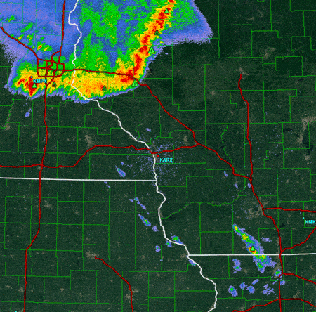 Radar loop between Midnight and 4 a.m. |
Peak Wind Reports:
PUBLIC INFORMATION STATEMENT
NATIONAL WEATHER SERVICE LA CROSSE WI
617 AM CDT MON JUL 13 2015


...WIND REPORTS PAST 12 HOURS ...

LOCATION                     SPEED     TIME/DATE       LAT/LON

...IOWA...

...WINNESHIEK COUNTY...
4 E NORDNESS                 30 MPH    0322 AM 07/13   43.25N/91.70W

...MINNESOTA...

...OLMSTED COUNTY...
ROCHESTER INTERNATIONAL AIRP 47 MPH    0137 AM 07/13   43.91N/92.50W
MAYO HELIPAD                 36 MPH    0113 AM 07/13   44.02N/92.48W
4 ESE DOUGLAS                32 MPH    0104 AM 07/13   44.09N/92.49W

...WINONA COUNTY...
WINONA MUNICIPAL AIRPORT     38 MPH    0134 AM 07/13   44.08N/91.71W

...WISCONSIN...

...CRAWFORD COUNTY...
1 SW MOUNT STERLING          51 MPH    0306 AM 07/13   43.31N/90.94W
PRAIRIE DU CHIEN  AIRPORT    35 MPH    0335 AM 07/13   43.02N/91.12W

...GRANT COUNTY...
1 ENE BOSCOBEL               39 MPH    0403 AM 07/13   43.15N/90.68W
PLATTEVILLE MUNICIPAL AIRPOR 37 MPH    0435 AM 07/13   42.69N/90.44W
BOSCOBEL AIRPORT             36 MPH    0329 AM 07/13   43.16N/90.67W

...JACKSON COUNTY...
BLACK RIVER FALLS AREA AIRPO 38 MPH    0135 AM 07/13   44.25N/90.86W
4 WNW BLACK RIVER FALLS      33 MPH    0108 AM 07/13   44.34N/90.91W

...JUNEAU COUNTY...
NECEDAH                      62 MPH    0248 AM 07/13   44.03N/90.08W
VOLK FIELD AIRPORT           57 MPH    0230 AM 07/13   43.94N/90.25W

...LA CROSSE COUNTY...
LA CROSSE REGIONAL AIRPORT   48 MPH    0157 AM 07/13   43.88N/91.26W
WFO LA CROSSE                39 MPH    0210 AM 07/13   43.82N/91.19W

...MONROE COUNTY...
4 NNW RIDGEVILLE             41 MPH    0208 AM 07/13   43.94N/90.60W

...TAYLOR COUNTY...
MEDFORD TAYLOR COUNTY AIRPOR 38 MPH    0135 AM 07/13   45.10N/90.30W
3 NE LUBLIN                  35 MPH    0114 AM 07/13   45.11N/90.69W

...VERNON COUNTY...
VIROQUA MUNICIPAL AIRPORT    35 MPH    0315 AM 07/13   43.58N/90.90W
ONTARIO                      30 MPH    0239 AM 07/13   43.72N/90.59W

OBSERVATIONS ARE COLLECTED FROM A VARIETY OF SOURCES WITH VARYING
EQUIPMENT AND EXPOSURE. NOT ALL DATA LISTED ARE CONSIDERED OFFICIAL.
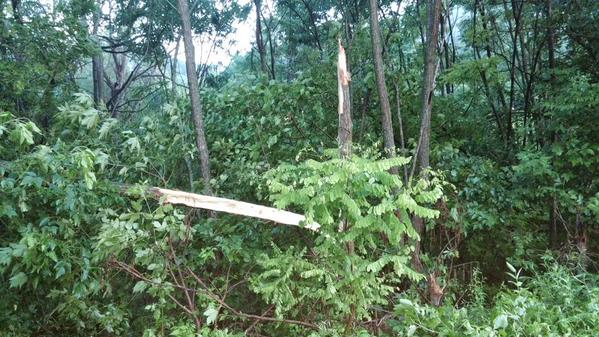
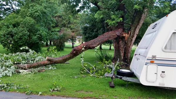
Photos:
 |
 |
||
| Tree damage near DeSoto, WI (Photo by Joanne Uehling) |
Damage near Readstown, WI (Photo by Bobbie G./WKBT) |
Storm Reports
PRELIMINARY LOCAL STORM REPORT...SUMMARY
NATIONAL WEATHER SERVICE LA CROSSE WI
819 AM CDT MON JUL 13 2015

...TIME...  ...EVENT...      ...CITY LOCATION...     ...LAT.LON...
...DATE...  ....MAG....      ..COUNTY LOCATION..ST.. ...SOURCE....
            ..REMARKS..

0233 AM     TSTM WND GST     2 NNE CAMP DOUGLAS      43.94N 90.25W
07/13/2015  M58 MPH          JUNEAU             WI   ASOS

            ASOS STATION VOLK FIELD AIRPORT /VOK/

0248 AM     TSTM WND GST     1 WNW NECEDAH           44.03N 90.08W
07/13/2015  M62 MPH          JUNEAU             WI   MESONET

            MESONET STATION NECEDAH /NEHW3/

0251 AM     TSTM WND DMG     4 ESE BUCKHORN STATE PAR43.91N 89.93W
07/13/2015                   ADAMS              WI   PUBLIC

            TREES DOWN IN CASTLE ROCK PARK.

0250 AM     TSTM WND DMG     ARKDALE                 44.03N 89.88W
07/13/2015                   ADAMS              WI   LAW ENFORCEMENT

            TREES DOWN. TIME ESTIMATED VIA RADAR.

0250 AM     TSTM WND DMG     MONROE CENTER           44.12N 89.96W
07/13/2015                   ADAMS              WI   LAW ENFORCEMENT

            TREES DOWN IN PETENWELL COUNTY PARK.
Rain Reports
PUBLIC INFORMATION STATEMENT
NATIONAL WEATHER SERVICE LA CROSSE WI
753 AM CDT MON JUL 13 2015


...RAINFALL REPORTS...

LOCATION                     AMOUNT

...IOWA...

...ALLAMAKEE COUNTY...
DORCHESTER 3S                0.17 IN
WATERVILLE 3SE               0.10 IN
WATSON 4ENE                  0.08 IN

...CLAYTON COUNTY...
ELKADER 6SSW                 0.43 IN
VOLGA 1NE                    0.42 IN
LITTLEPORT                   0.37 IN
ELKADER                      0.27 IN
BLOODY RUN CREEK             0.16 IN
GARBER                       0.12 IN
GUTTENBERG DAM 10            0.08 IN

...FAYETTE COUNTY...
ELDORADO                     0.01 IN

...WINNESHIEK COUNTY...
DECORAH                      0.08 IN

...MINNESOTA...

...FILLMORE COUNTY...
CHATFIELD 9ESE               0.72 IN
LANESBORO                    0.45 IN
WHALAN 3.3 SSE               0.40 IN
SO.FORK ROOT RIVER           0.35 IN
MABEL                        0.05 IN

...HOUSTON COUNTY...
LA CRESCENT 0.7 NNW          1.20 IN
HOUSTON                      0.86 IN
CALEDONIA                    0.69 IN
MOUND PRAIRIE                0.68 IN

...OLMSTED COUNTY...
ELGIN 2SSW                   1.20 IN
ELBA 5SW                     1.16 IN
HAMMOND 3SW                  1.00 IN
DOUGLAS 4ESE                 0.65 IN
ORONOCO 1W                   0.65 IN
4 NNW ROCHESTER              0.63 IN
ORONOCO                      0.60 IN
3 NE ROCHESTER               0.56 IN
PINE ISLAND 1S               0.52 IN
1 W CHESTER                  0.49 IN
3 ESE DOUGLAS                0.48 IN
2 ENE ROCHESTER              0.46 IN
ROCHESTER 2.6 NE             0.43 IN
CASCADE CREEK                0.35 IN
2 NE ROCHESTER               0.30 IN
3 NW ROCHESTER               0.26 IN
BELTLINE-BEAR CREEK          0.19 IN
MAYO HELIPAD                 0.17 IN
ROCHESTER BELTLINE           0.14 IN
BYRON 4 NORTH                0.12 IN
ROCHESTER 3W                 0.08 IN
BYRON                        0.04 IN
ROCHESTER AP 2NE             0.03 IN

...WABASHA COUNTY...
LAKE CITY                    1.49 IN   0717 AM 07/13   44.45N/92.27W
WABASHA                      1.41 IN   0700 AM 07/13   44.38N/92.05W
ZUMBRO FALLS 3.5 SSW         1.26 IN   0630 AM 07/13   44.24N/92.46W
MAZEPPA 3ESE                 1.13 IN   0730 AM 07/13   44.26N/92.49W
ZUMBRO RIVER                 1.10 IN   0700 AM 07/13   44.32N/92.00W
BEAR VALLEY                  0.85 IN   0551 AM 07/13   44.32N/92.44W

...WINONA COUNTY...
1 E WINONA                   1.12 IN   0725 AM 07/13   44.05N/91.63W
MINNESOTA CITY DAM 5         1.12 IN   0700 AM 07/13   44.16N/91.81W
TREMPEALEAU DAM 6            1.03 IN   0600 AM 07/13   44.00N/91.44W
LEWISTON 0.2 NW              1.00 IN   0700 AM 07/13   43.99N/91.87W
DAKOTA                       0.97 IN   0700 AM 07/13   43.91N/91.36W
WINONA MUNICIPAL AIRPORT     0.95 IN   0654 AM 07/13   44.08N/91.71W
LA CRESCENT DAM 7            0.93 IN   0600 AM 07/13   43.87N/91.31W
WINONA DAM 5A                0.87 IN   0600 AM 07/13   44.09N/91.67W
WHITEWATER RIVER NEAR BEAVER 0.83 IN   0645 AM 07/13   44.15N/92.00W

...WISCONSIN...

...BUFFALO COUNTY...
ALMA DAM 4                   1.15 IN   0600 AM 07/13   44.33N/91.92W

...CLARK COUNTY...
NEILLSVILLE 1NW              1.75 IN   0700 AM 07/13   44.56N/90.61W
NEILLSVILLE 1W               1.70 IN   0200 AM 07/13   44.56N/90.61W

...CRAWFORD COUNTY...
DE SOTO                      0.48 IN   0731 AM 07/13   43.42N/91.19W
STEUBEN                      0.48 IN   0645 AM 07/13   43.18N/90.86W
STEUBEN 4SE                  0.35 IN   0700 AM 07/13   43.13N/90.84W
PRAIRIE DU CHIEN             0.23 IN   0700 AM 07/13   43.05N/91.13W
LYNXVILLE DAM 9              0.18 IN   0600 AM 07/13   43.21N/91.10W
PRAIRIE DU CHIEN  AIRPORT    0.18 IN   0655 AM 07/13   43.02N/91.12W

...GRANT COUNTY...
BOSCOBEL AIRPORT             0.76 IN   0653 AM 07/13   43.16N/90.67W
1 ENE BOSCOBEL               0.70 IN   0703 AM 07/13   43.15N/90.68W
MUSCODA                      0.32 IN   0645 AM 07/13   43.20N/90.44W
PLATTEVILLE MUNICIPAL AIRPOR 0.10 IN   0655 AM 07/13   42.69N/90.44W

...JACKSON COUNTY...
1 E BLACK RIVER FALLS        1.54 IN   0715 AM 07/13   44.30N/90.83W
BLACK RIVER FALLS AREA AIRPO 1.36 IN   0655 AM 07/13   44.25N/90.86W
MATHER 3NW                   1.18 IN   0700 AM 07/13   44.17N/90.35W
HIXTON                       0.91 IN   0306 AM 07/13   44.39N/91.02W
TAYLOR                       0.87 IN   0256 AM 07/13   44.32N/91.13W
NORTHFIELD                   0.55 IN   0327 AM 07/13   44.46N/91.10W

...JUNEAU COUNTY...
MAUSTON                      1.36 IN   0727 AM 07/13   43.80N/90.07W
NECEDAH 5.0 ESE              1.06 IN   0700 AM 07/13   43.99N/89.99W
UNION CENTER                 1.00 IN   0700 AM 07/13   43.68N/90.26W
VOLK FIELD AIRPORT           0.94 IN   0658 AM 07/13   43.94N/90.25W
3 NW DELLWOOD                0.91 IN   0730 AM 07/13   44.00N/89.99W
NECEDAH                      0.76 IN   0648 AM 07/13   44.03N/90.08W

...LA CROSSE COUNTY...
HOLMEN 2S                    0.95 IN   0700 AM 07/13   43.93N/91.25W
LA CROSSE 4NNW               0.93 IN   0730 AM 07/13   43.87N/91.27W
LA CROSSE WEATHER OFFICE     0.89 IN   0600 AM 07/13   43.82N/91.19W
1 SW LA CROSSE               0.85 IN   0708 AM 07/13   43.81N/91.25W
LA CROSSE REGIONAL AIRPORT   0.84 IN   0653 AM 07/13   43.88N/91.26W
FOUR CORNERS                 0.44 IN   0700 AM 07/13   44.07N/90.92W

...MONROE COUNTY...
TOMAH 5NNW                   1.25 IN
WARRENS 4WSW                 1.09 IN
TOMAH 5N                     1.06 IN
CATARACT 2E                  0.74 IN

...TAYLOR COUNTY...
LUBLIN 3NE                   1.13 IN
MEDFORD AIRPOR               0.89 IN

...TREMPEALEAU COUNTY...
WHITEHALL 6N                 1.10 IN
GALESVILLE 2WSW              0.99 IN
ELK CREEK                    0.98 IN
TREMPEALEAU 1.8 NW           0.88 IN
GALESVILLE 1WSW              0.87 IN
WHITEHALL 4SSW               0.87 IN
ETTRICK 4WNW                 0.86 IN
INDEPENDENCE                 0.83 IN
WHITEHALL                    0.83 IN
BLAIR                        0.82 IN

...VERNON COUNTY...
READSTOWN                    1.03 IN   0700 AM 07/13   43.45N/90.76W
SEAS BRANCH HAUGEN           1.02 IN   0410 AM 07/13   43.61N/90.85W
STODDARD                     0.98 IN   0700 AM 07/13   43.66N/91.22W
DAHLEN DAM                   0.91 IN   0434 AM 07/13   43.70N/90.85W
KLINKNER DAM                 0.90 IN   0409 AM 07/13   43.70N/90.74W
VIROQUA                      0.86 IN   0700 AM 07/13   43.56N/90.88W
VIROQUA MUNICIPAL AIRPORT    0.86 IN   0655 AM 07/13   43.58N/90.90W
GENOA DAM 8                  0.83 IN   0600 AM 07/13   43.57N/91.23W
LA FARGE                     0.83 IN   0500 AM 07/13   43.57N/90.64W
YTTRI DAM                    0.83 IN   0412 AM 07/13   43.55N/90.82W
HIDDEN VALLEY DAM            0.71 IN   0635 AM 07/13   43.62N/90.81W
SEAS BRANCH DAM              0.71 IN   0644 AM 07/13   43.61N/90.82W
HILLSBORO WSW                0.70 IN   0700 AM 07/13   43.65N/90.35W
SIDIE HOLLOW DAM             0.67 IN   0326 AM 07/13   43.54N/90.96W
VIROQUA 0.8 ESE              0.65 IN   0700 AM 07/13   43.55N/90.87W
THOMPSON DAM                 0.59 IN   0536 AM 07/13   43.49N/90.95W
ONTARIO                      0.39 IN   0200 AM 07/13   43.72N/90.59W
RUNGE HOLLOW DAM             0.20 IN   0653 AM 07/13   43.61N/91.01W

OBSERVATIONS ARE COLLECTED FROM A VARIETY OF SOURCES WITH VARYING
EQUIPMENT AND EXPOSURE. NOT ALL DATA LISTED ARE CONSIDERED OFFICIAL.

$$

NWS LA CROSSE WI
 |
Media use of NWS Web News Stories is encouraged! Please acknowledge the NWS as the source of any news information accessed from this site. |
|


 Weather Story
 Weather Map
 Local Radar