National Weather Service United States Department of Commerce

Storm Impacting the Northwest U.S.; Fire Weather Conditions in Southern California; Severe Weather in the South

A Pacific storm is bringing areas of low elevation rain, moderate to heavy mountain snow, and high winds to the Northwest. Strong Santa Ana winds and very dry conditions are producing elevated to critical fire weather conditions in southern California. Isolated strong to severe thunderstorms are possible through early Wednesday morning across parts of northeast Texas into western Tennessee. Read More >

Below are some Palm Sunday climate statistics for La Crosse, WI, and Rochester, MN.

La Crosse, WI:

The following statistics comprise 151 years of data. From 1873 through 1950, the data came from various locations in downtown La Crosse. Since 1950, the data has been gathered at La Crosse Regional Airport.

Palm Sunday in La Crosse, WI
(Period of Record 1873-2023)
1991-2020 Normals
Records
Maximum Temperature
45°F to 61°F
(March 15 to April 18)
Warmest High Temperature
76°F
April 14, 1946
Coldest High Temperature
19°F
March 30, 1969
Minimum Temperature
26°F to 39°F
(March 15 to April 18)
Warmest Low Temperature
60°F
April 9, 2017
Coldest Low Temperature
-4°F
March 19, 1989
Average Temperature
35°F to 50°F
(March 15 to April 18) 
Warmest Average Temperature
67.5°F
April 9, 2017
Coldest Average Temperature
10.5°F
March 30, 1969
Precipitation
0.06" to 0.13"
(March 15 to April 18)
Wettest
2.06"
April 15, 1973
Snowfall
0.2" to 0.1"
(March 15 to April 18)
Snowiest
6.1"
March 18, 1951
Snow Depth at 7 AM
2" to 0"
(March 15 to April 18)
Most Snow on the Ground at
7 AM
13"
March 22, 1959


The odds of having any precipitation at all on Palm Sunday are 43.3% (65 out of 151).  There has been measurable (0.01" or greater) precipitation on 46 (30.5%) Palm Sundays and trace amounts of precipitation on another 19 (12.6%) Palm Sundays. 

It has snowed on 27 out of 127 (21.3%) Palm Sundays. Measurable snow (0.1" or greater) has fallen on 11 (8.7%) Palm Sundays and trace amounts of snow on another 16 (12.6%) Palm Sundays.

Residents have woken up with measurable snow (1/2" or greater) on the ground 20 times (15.3%), trace amounts (less than a 1/2") 11 times (8.4%), and no snow 100 times (76.3%).

In 2024, Palm Sunday will be on March 24.  Since 1873, Palm Sunday has occurred on this date, 6 times (1907,1918, 1929, 1991, 2002, and 2013). 

Year High Low Precipitation Snow Snow Depth
1907 61°F 34°F 0.00" 0.0" 0"
1918 61°F 28°F 0.00" 0.0" 0"
1929 47°F 35°F 0.00" 0.0" 0"
1991 NA NA 0.00" 0.0" 0"
2002 39°F 19°F 0.00" 0.0" 0"
2013 33°F 29°F 0.02" 0.2" 4"


The next time Palm Sunday will occur on this date is 2034.  After that, it will not fall on this date again until 2045.  In 2024, Palm Sunday will fall on March 24.  This will be the first time since 2013.

In 2023 (April 2), the high temperature was 65°F and the low temperature was 27°F.  No precipitation fell and there was no snow on the ground that morning.  The average wind speed was 12.7 mph.


Rochester, MN:

The following statistics comprise 109 years of data. From 1887 through 1931, the data came from several cooperative observers in the Rochester area. Since 1932, the data has been gathered at Rochester International Airport. No data was taken on Palm Sunday from 1889 to 1891, 1908, and 1921 to 1928.

Palm Sunday in Rochester, MN
(Period of Record 1887-2023)
1991-2020 Normals
Records
Maximum Temperature
39°F to 57°F
(March 15 to April 18)
Warmest High Temperature
74°F
April 13, 1930
Coldest High Temperature
16°F
March 30, 1969
Minimum Temperature
23°F to 36°F
(March 15 to April 18)
Warmest Low Temperature
54°F
March 25, 1945
Coldest Low Temperature
-5°F
March 19, 1989
Average Temperature
31°F to 46°F
(March 15 to April 18) 
Warmest Average Temperature
61.5°F
April 13, 1930
Coldest Average Temperature
6.0°F
March 30, 1969
Precipitation
0.06" to 0.12"
(March 15 to April 18)
Wettest
1.25"
April 15, 1973
Snowfall
0.3" to 0.1"
(March 15 to April 18)
Snowiest
7.4"
March 31, 1985
Snow Depth at 7 AM
4" to 0"
(March 15 to April 18)
Most Snow on the Ground
at 7 AM
19"
March 18, 1951


The odds of having any precipitation at all on Palm Sunday are 40.7% (44 out of 108).  There has been measurable (0.01" or greater) precipitation on 34 (31.5%) Palm Sundays and trace amounts of precipitation on another 10 (9.3%) Palm Sundays. 

It has snowed on 22 out of 105 (21.0%) Palm Sundays. Measurable snow (0.1" or greater) has fallen on 17 (16.2%) Palm Sundays and trace amounts of snow on another 5 (4.8%) Palm Sundays.

Residents have woken up with measurable snow (1/2" or greater) on the ground 21 times (26.3%), trace amounts (less than a 1/2") 12 times (15%), and no snow 47 times (58.8%).

In 2024, Palm Sunday will be on March 24.  Since 1873, Palm Sunday has occurred on this date, 6 times (1907,1918, 1929, 1991, 2002, and 2013). 

Year High Low Precipitation Snow Snow Depth
1907 NA NA NA NA NA
1918 54°F 25°F 0.00" 0.0" NA
1929 36°F 32°F 0.00" 0.0" NA
1991 52°F 32°F 0.01" 0.1" Trace
2002 34°F 15°F 0.00" 0.0" 0"
2013 32°F 24°F 0.02" Trace 10"


The next time Palm Sunday will occur on this date is 2034.  After that, it will not fall on this date again until 2045.  In 2024, Palm Sunday will fall on March 24.  This will be the first time since 2013.

In 2023 (April 2), the high temperature was 54°F and the low temperature was 22°F.  No precipitation fell and there was 2" of snow on the ground that morning.  The average wind speed was 16.9 mph.


Palm Leaf

Palm Sunday
Weather History

Palm Leaf


The following weather events affected southeast Minnesota, northeast Iowa, and western Wisconsin on Palm Sunday:
  • In 1942 (March 29), 6 inches of snow fell in Viroqua, WI fell.
  • In 1951, heavy snow began to fall on March 17th and continued into March 18th (Palm Sunday).  This snow was accompanied by high winds delayed traffic seriously. Many side roads and a number of main roads and highways were blocked by huge drifts.  Many automobiles and trains were stalled, travelers were stranded, and schools closed.  In Minnesota, one death and a number of personal injuries were reported as a result of accidents, etc. during the storm which assumed near-blizzard properties in some localities.  Some snow amounts included:
    • In IA: Cresco (10"), Osage (10"), New Hampton (8"), Dorchester (6"), and Waukon (6").
    • In MN: Harmony (12"), Spring Grove (12"), Winona (11"), Minnesota City (10"), Theilman (9.1"), Grand Meadow (9"), Lake City (8.5"), Austin (8"), La Crescent (8"), Rochester (7.1"), and Caledonia (7").
    • In WI: Hatfield (15"), Mondovi (11.3"), Mather (9"), Alma (8"), Trempealeau (7.5"), Galesville (7"), Neillsville (7"), Owen (6"), Sparta (6"), and West Salem (6").
       
  • On Palm Sunday 1965 (April 11), at least one barn was totally destroyed as a very narrow F2 tornado tracked northeast across Crawford County, WI from 3 miles south of Gays Mills to 4 miles east of Soldiers Grove.  Another F2 touched down 4.5 miles west of Tomah, WI, destroying sheds and barns on a farm.  Also, an F1 tornado touched down in Chickasaw County, IA.  None of these tornadoes caused any injuries or deaths.  These tornadoes were part of the Palm Sunday Outbreak (April 11-12) which was the second most damaging outbreak of the 20th century.  During this outbreak, nearly 50 tornadoes struck parts of the Great Lakes region from Wisconsin and Illinois eastward through Lower Michigan and northern Ohio.  The outbreak resulted in 256 deaths and 3,402 injuries.
     
    Aoril 11-12, 1965 Palm Sunday Tornado Outbreak 
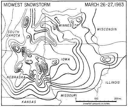
  • In 1983, an intense low pressure system produced heavy snow in the Midwest from Friday evening (March 25th) through Palm Sunday (March 27th) morning.  Snow depths were highly variable due to the fact that convective activity caused many locally heavy amounts.  The snow combined with strong winds, severely reduced visibilities and produced terrible driving conditions. In western and northern Iowa, the main storm damage of the storm was to trees and power lines.  The wet accumulation downed many branches and tree limbs as well as power lines, damaging houses and resulting in electrical power loss to tens of thousands of homes and businesses.  Most power outages only lasted a few hours, but some homes in rural areas were without electricity for up to 2 days.  WHO-TV in Des Moines was off for two hours due to transmitter trouble and several radio stations were off the air due to the storm.  Three buildings (one in Creston, one in Collins, and one in Lake View) collapsed due to the weight of snow on the roof.  Locally, both Austin, MN (Mower County) and Marble Rock, IA (Floyd County) received 6 inches of snow, and 6 to 8 inches of snow fell across extreme southern Grant and Lafayette counties.

March 26-27, 1983 Snow Totals

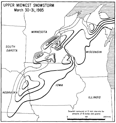
  • In 1985, a late-season snowstorm left a band of wet, heavy snow from eastern Nebraska to the Upper Peninsula of Michigan on March 30th and March 31st (Palm Sunday). Some of the heaviest snowfall, up to 16 inches, was reported in the urban areas of Minneapolis-St. Paul, MN.

    In Iowa, the heaviest accumulation (about 10") occurred in west-central Iowa and more than six inches fell from Hawarden to Glenwood, northeast to Estherville and Waukon.  Travel became treacherous.  The following snow totals were reported in northeast Iowa:  Decorah (7.5"), Cresco (6"), Dorchester (6"), New Hampton (6"), and Osage (6").

    In Minnesota, the snow spread into southern Minnesota during the evening of March 30th.  The snow initially melted as it fell, but by 1:30 AM on the morning of March 31st (Palm Sunday), 6 inches of snow had accumulated in Nobles County in southwest Minnesota.  Snow accumulations increased during the morning of March 31st and reached 6 to 10 inches south of a line from Redwood Falls to just south of Duluth.  Winds of 30 to 40 miles per hour caused some blowing and drifting snow. Additional snowfall became light after mid-afternoon on March 31st.  The following snow totals were reported in southeast Minnesota: Lake City (9"), Rochester (7.4"), Austin (7"), and Harmony (7").

    In Wisconsin, the storm brought heavy snow to the north and west sections while the south and east received periods of freezing rain and sleet.  Between 6 and 14 inches of heavy wet snow fell mainly north of a line from La Farge in Vernon County to Iron Mountain, Michigan. Fourteen inches were noted at Lake Thompson in Oneida county and 13 inches were deposited at Baldwin in St. Croix County.  Brisk northwest winds caused considerable blowing and drifting snow which quickly closed several highways and impeded plowing operations.  In the south and east, freezing rain coated many power lines and trees, causing numerous power outages.  Roadways were also ice-covered and sleet fell in many areas, causing next to impossible driving conditions.  The following snow totals were reported in western Wisconsin: Jump River (11"), Mondovi (8"), Caledonia (6"), Cashton (6"), and Genoa (6").

March 30-31, 1985 Snow Totals

  • In 1995 (April 9), a quick-hitting convective snowstorm stuck southwest and central Wisconsin with thunder, lightning, extremely large snowflakes, and sleet.  The event began in the evening and continued into the early morning hours of the 10th. The width of the heavy snow band was only 20 miles extending from La Crosse to Wisconsin Dells to Green Lake.  At the height of the storm, visibilities were near zero.  Some accumulations include: Wisconsin Dells (12"), La Crosse (8"), La Farge (8"), Stoddard (8"), and Yuba (6").
  • In 2022 (April 10), southeast winds gusted into the 30 to 50 mph range. The highest winds were 45 mph near Dexter, MN; 46 mph at Rochester International Airport, and 49 mph at Oelwein Municipal Airport.