Extremely critical fire weather concerns for portions of the southern High Plans as strong wind and very dry conditions could result in rapid spread of any fires. Meanwhile, severe thunderstorms are expected once again across areas of the Central and Southern Plains, then spreading in the Mississippi Valley regions on Monday. Damaging winds, very large hail and strong tornadoes are possible. Read More >
Below are some New Year's Eve weather statistics for La Crosse, WI, and Rochester, MN.
La Crosse, WI:
The following statistics comprise 153 years of data. From 1873 through 1950, the data came from various locations in downtown La Crosse. Since 1950, the data has been gathered at La Crosse Regional Airport.
| New Year's Eve in La Crosse, WI (Period of Record 1873-2024) |
||||
|
1991-2020 Normals
|
Records
|
|||
| Maximum Temperature |
29°F
|
Warmest High Temperature |
59°F
|
December 31, 1965
|
| Coldest High Temperature |
-9°F
|
December 31, 1968
|
||
| Minimum Temperature |
13°F
|
Warmest Low Temperature |
39°F
|
December 31, 1949
|
| Coldest Low Temperature |
-20°F
|
December 31, 1976
|
||
| Average Temperature |
21°F
|
Warmest Average Temperature |
44.5°F
|
December 31, 1875
|
| Coldest Average Temperature |
-12.0°F
|
December 31, 1898
|
||
| Precipitation |
0.04"
|
Wettest |
0.59"
|
December 31, 2006
|
| Snowfall |
0.4"
|
Snowiest |
6.2"
|
December 31, 1911
|
| Snow Depth at 6 AM |
4"
|
Most Snow on the Ground at 6 AM |
20"
|
December 31, 1968
|
The odds of having any precipitation at all on New Year's Eve is 54.9% (84 out of 153). There has been measurable (0.01" or greater) precipitation on 45 New Year's Eves (29.4%) and trace amounts (less than 0.01") of precipitation on 39 New Year's Eves (25.5%). Precipitation has fallen on 12 of the last 15 New Year's Eves. While that has been the case, the precipitation has been on the light side with precipitation totals ranging from just a trace to 0.08 inches (2018).
It has snowed on 67 out of 129 (51.6%) New Year's Eves. Measurable snow (0.1" or greater) has fallen on 28 New Year's Eves (21.7%) and trace amounts on 39 New Year's Eves (30.2%). Light snow (from a dusting to 0.9") has fallen on 10 out of the last 13 New Year's Eves.
Since 1893, residents have woken up with measurable snow (1/2" or greater) on the ground 91 times (69.5%), trace amounts 20 times (15.3%), and no snow 20 times (15.3%).
In 2024, the high temperature was 35°F and the low temperature was 30°F. A trace of precipitation and snow fell. There was no snow on the ground at 7 AM. This was first time since 2006. The average wind speed was 3.5 mph.
Rochester, MN:
The following statistics comprise 112 years of data. From 1887 through 1931, the data came from several cooperative observers in the Rochester area. Since 1932, the data has been gathered at Rochester International Airport. No data was taken on New Year's Eve from 1890, 1891, 1908, 1909, from 1921 to 1928.
| New Year's Eve in Rochester, MN (Period of Record 1887-2024) |
||||
|
1991-2020 Normals
|
Records
|
|||
| Maximum Temperature |
24°F
|
Warmest High Temperature |
49°F
|
December 31, 1965
|
| Coldest High Temperature |
-12°F
|
December 31, 1968
|
||
| Minimum Temperature |
9°F
|
Warmest Low Temperature |
32°F
|
December 31, 1949
|
| Coldest Low Temperature |
-28°F
|
December 31, 1946
|
||
| Average Temperature |
17°F
|
Warmest Average Temperature |
37.0°F
|
December 31, 2006
|
| Coldest Average Temperature |
-16.5°F
|
December 31, 1968
|
||
| Precipitation |
0.03"
|
Wettest |
0.75"
|
December 31, 1911
|
| Snowfall |
0.4"
|
Snowiest |
7.8
|
December 31, 1911
|
| Snow Depth at 6 AM |
5"
|
Most Snow on the Ground at 6 AM |
19"
|
December 31, 2010
December 31, 2000 December 31, 1968 |
The odds of having any precipitation at all on New Year's Eve is 57.1% (64 out of 112). There has been measurable (0.01" or greater) precipitation on 26 New Year's Eves (23.2%) and trace amounts (less than 0.01") of precipitation on 38 New Year's Eves (33.9%). Precipitation has fallen on 12 of the last 14 New Year's Eves. While that has been the case, the precipitation has been on the light side with precipitation totals ranging from just a trace to 0.08 inches (2011).
It has snowed on 57 out of 109 (52.3%) New Year's Eve's. Measurable snow (0.1" or greater) has fallen on 18 New Year's Eves (16.5%) and a trace of snow has fallen on 39 New Year's Eves (35.8%). Snowfall has fallen on 11 out of the last 15 New Year's Eves. While that has been the case, the snowfall has been on the light side with snow totals ranging from just a dusting (9 times) to 1.3 inches (2013).
Since 1893, residents have woken up with measurable snow (1/2" or greater) on the ground 66 times (74.2%), no snow 10 times (11.2%), and trace amounts (less than a 1/2") 13 times (14.6%).
In 2024, the high temperature was 31°F and the low temperature was 23°F. There was no precipitation. There was no snow on the ground at 7 AM. This was the second year in row. This was first time that this has occurred. The average wind speed was 4 mph.
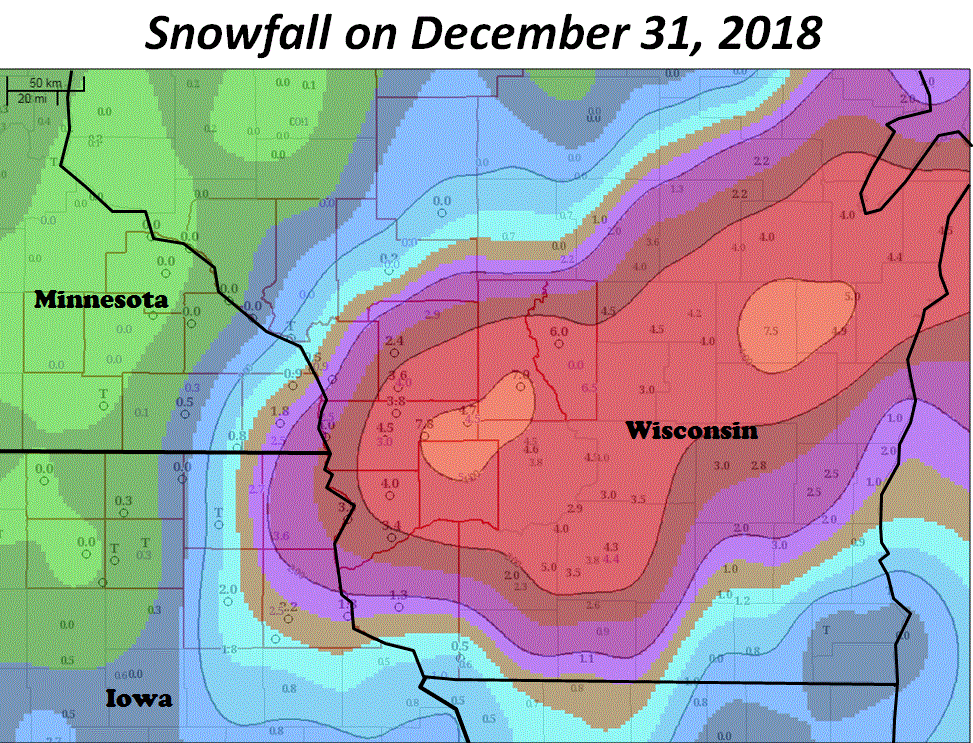
The following weather events happened on New Year's Eve:
