Overview
|
Snow spread into the area during the afternoon hours on Saturday, December 10th, continuing into the afternoon hours of the following day (Dec.11th). An enhanced band of snowfall developed around the Interstate 90 corridor late Saturday evening, and would gradually shift northeast to Interstate 94 early Sunday morning. Snowfall rates of up to 1" per hour were common in this band. The snow was light and fluffy, but winds were not that strong keeping impact lower - mainly because of snow covered roads. |
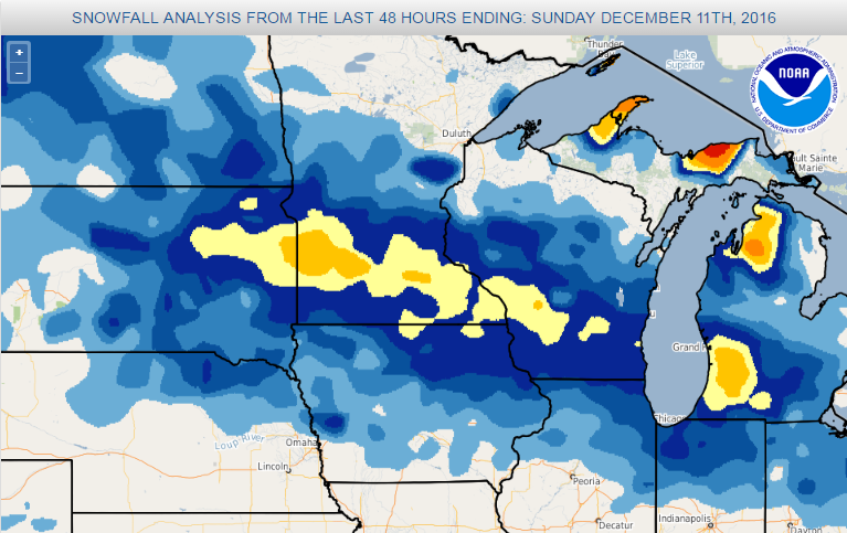 Snowfall total for Dec.10-11th |
Snow
The higher totals fell along and north of Interstate 90.
Public Information Statement
National Weather Service La Crosse WI
130 PM CST Sun Dec 11 2016

...December 10-11 Snowfall Reports...

Location                     Amount

...Iowa...

...Allamakee County...
Harpers Ferry                4.0 in

...Chickasaw County...
New Hampton                  5.0 in
2 SW Nashua                  4.0 in
2 W Ionia                    4.0 in

...Clayton County...
Monona WWTP                  4.7 in
Elkader                      4.4 in
Edgewood                     4.0 in
GUTTENBERG DAM 10            3.5 in
Strawberry Point             3.2 in

...Fayette County...
Fayette                      5.3 in
Oelwein                      3.5 in
West Union                   3.0 in

...Floyd County...
Charles City                 4.0 in

...Howard County...
Cresco 1NE                   6.3 in
Elma                         3.5 in

...Mitchell County...
Riceville                    5.0 in
St Ansgar                    4.6 in
Osage                        4.0 in

...Winneshiek County...
Decorah                      6.0 in
Calmar NE                    5.2 in
Decorah 5ESE                 5.2 in

...Minnesota...

...Dodge County...
Kasson                       6.5 in
Mantorville                  6.0 in

...Fillmore County...
Harmony                      8.0 in
Lanesboro                    6.0 in
1 S Peterson                 5.6 in
Preston                      5.4 in
1 W Fillmore                 5.0 in
Mabel                        5.0 in
Spring Valley                4.0 in

...Houston County...
Eitzen 4NW                   7.5 in
Hokah 4NW                    7.0 in
La Crescent                  6.6 in
3 ENE Mound Prairie          6.5 in
Hokah                        6.2 in
Caledonia                    5.7 in
Spring Grove 4N              5.5 in

...Mower County...
1 WSW Austin                 7.3 in
Austin WWTP                  6.6 in
Grand Meadow                 6.0 in

...Olmsted County...
Rochester Intl Airport       8.3 in
Oronoco                      7.6 in
4 ESE Douglas                7.0 in
2 SW Predmore                6.5 in
1 SSE Rochester              6.5 in
2 SSW Marion                 6.5 in
Stewartville 1NW             6.4 in
Elgin 2SSW                   6.2 in
Rochester 2NE                6.0 in
Byron 4N                     6.0 in

...Wabasha County...
3 NNW Zumbro Falls          10.0 in
NW Plainview                 7.0 in
Theilman                     6.7 in
Lake City                    6.0 in
1 NE Wabasha                 5.5 in
Wabasha                      4.6 in

...Winona County...
Winona                       9.3 in
Minnesota City               9.0 in
Winona Dam 5A                8.0 in
1 S Winona                   7.2 in
4 S Winona                   7.0 in
1 N Pickwick                 7.0 in
Goodview                     6.5 in

...Wisconsin...

...Adams County...
Lake Camelot                 7-8 in
Adams                        5.7 in
Friendship                   4.0 in

...Buffalo County...
Alma                         6.0 in
Mondovi                      6.0 in

...Clark County...
Humbird                      8.0 in
Owen 2N                      6.4 in
Owen 3W                      3.8 in
6 N Chili                    3.0 in

...Crawford County...
Lynxville Dam 9              7.0 in
1 WNW Mount Zion             4.5 in
Steuben 4SE                  3.8 in
Prairie du Chien             3.0 in

...Grant County...
Platteville                  5.5 in
Cassville                    4.5 in

...Jackson County...
Black River Falls            4.5 in
Black River Falls 1.7 NNE    3.7 in

...Juneau County...
Mauston                      6.0 in
Lyndon Station               4.0 in
Necedah                      4.0 in

...La Crosse County...
La Crosse Regional Airport   9.8 in
NWS La Crosse                9.4 in
La Crosse 4NNW               8.4 in
5 WSW Saint Joseph           7.0 in
La Crosse 5SSE               6.6 in
Holmen 2S                    6.5 in
West Salem                   6.0 in
1 WNW Holmen                 5.5 in

...Monroe County...
Kendall                      8.3 in
5 SSW Sparta                 7.5 in
4 WSW Warrens                7.4 in
Sparta                       7.0 in
Four Corners                 6.8 in
Cashton 3NNW                 6.5 in

...Richland County...
Town of Ithaca               6.5 in

...Taylor County...
Medford                      7.0 in

...Trempealeau County...
Arcadia                      7.5 in
Galesville 2WSW              7.5 in
Trempealeau                  7.4 in
Ettrick 4WNW                 7.2 in
Centerville                  7.0 in
Trempealeau Dam 6            6.9 in
2 SSE Elk Creek              6.0 in
Elk Creek                    6.0 in
Arcadia                      5.8 in
1 NE Galesville              5.5 in

...Vernon County...
Ontario                      8.0 in
Westby 3N                    8.0 in
Westby 3ENE                  7.6 in
Hillsboro WSW                7.3 in
Stoddard 3NE                 6.6 in
La Farge                     6.5 in
Valley 1NW                   6.0 in
Viroqua                      5.8 in
Hillsboro 2SW                5.7 in
Stoddard                     5.5 in
Genoa Dam 8                  5.0 in

Observations are collected from a variety of sources with varying
equipment and exposures. Not all data listed are considered official.
Photos:
 |
 |
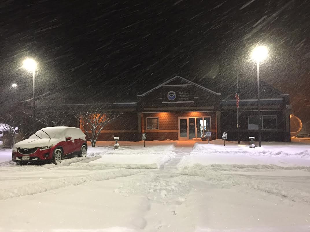
| NWS La Crosse at 5 am Dec.11th (Photo by NWS La Crosse) |
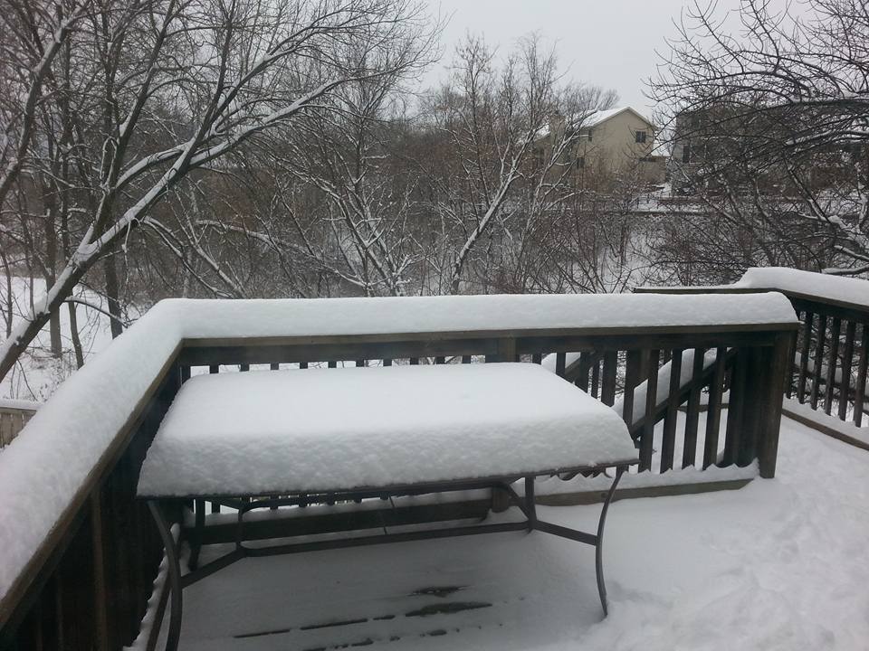
Snow just southeast of La Crosse (Photo by Bill Graul) |
 |
Media use of NWS Web News Stories is encouraged! Please acknowledge the NWS as the source of any news information accessed from this site. |
|


 Weather Story
 Weather Map
 Local Radar