Overview
|
A line of severe thunderstorms formed across southern Minnesota and produced damaging wind along and just south of Interstate 90 in southeast Minnesota. Wind gusts reached 60-70 mph from just southwest of Rochester, MN to near Preston, MN. As the storms moved into far northeast Iowa and western Wisconsin they were weakening but still produced gusts of 35 to 50 mph in many locations. In addition, additional storms formed later that same night, into the morning hours of Friday August 19th, which brought several more inches of rain to parts of the region. Some spots received 2-5" of rain which led to additional street and flash flooding. |
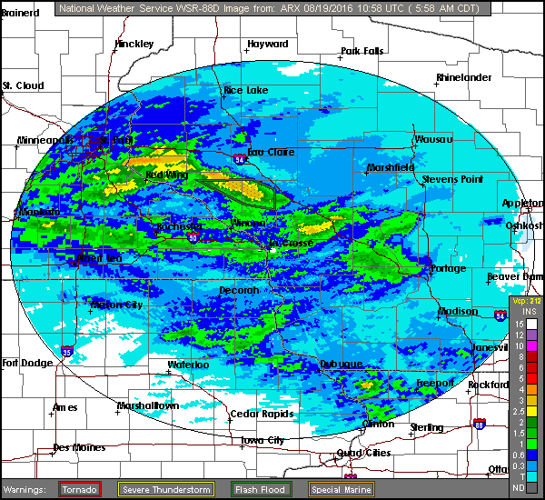
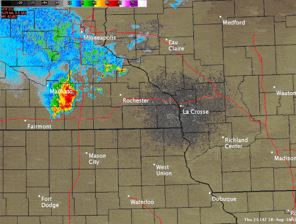 Radar loop between 4-7 p.m. on August 18, 2016 |
Photos:
 |
 |
 |
 |
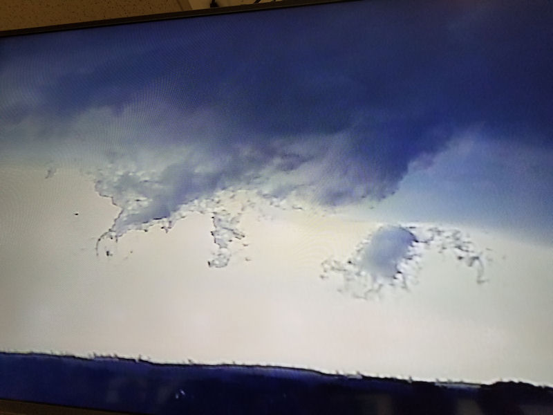
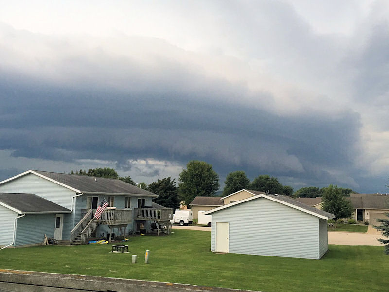
| Photo off of webcam showing "scud" clouds moving through La Crosse area. | Shelf cloud in West Salem, WI (Photo used with permission from Jordan Villont) |
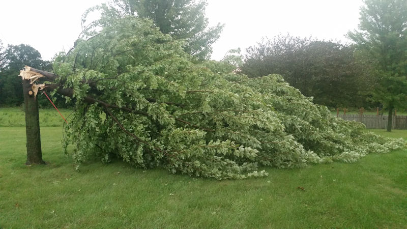
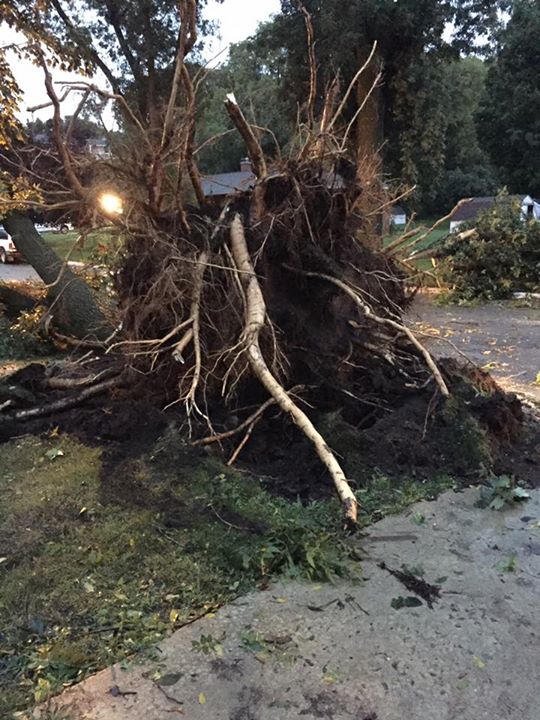
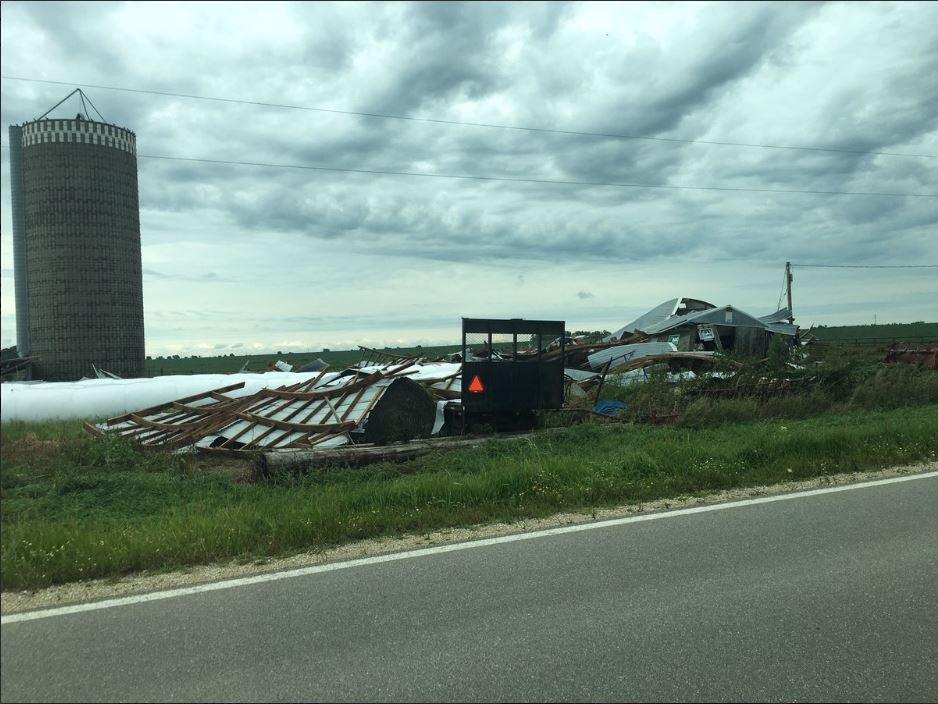
Storm damage north of Spring Valley, MN (Photo used with permission from Kris DeGeus) |
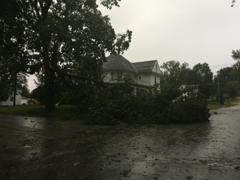
Tree damage in Preston, MN (Photo used with permission from David Duxbury) |
 |
 |
 |
 |
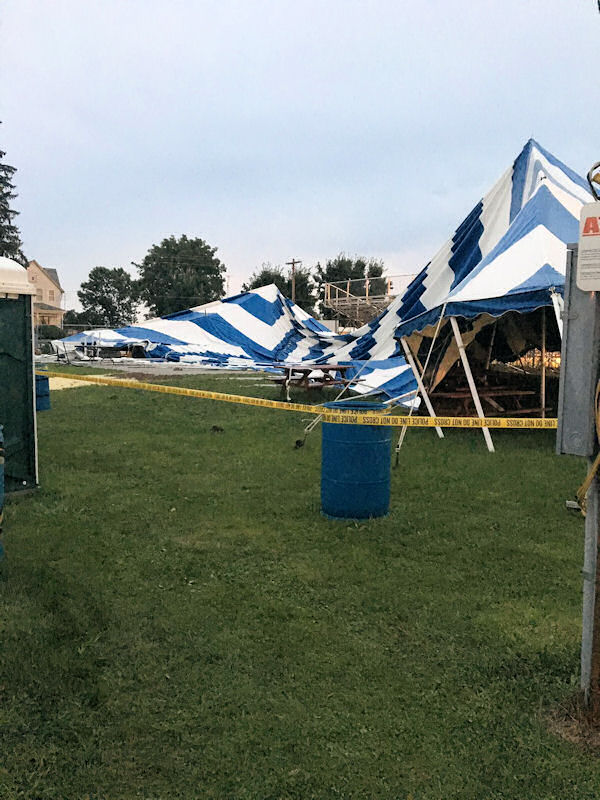
| Tent damage at the Houston County Fair (Caledonia, MN) (Photo used with permission from Amanda Rahn) |
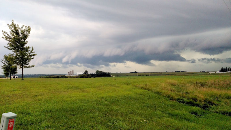
Shelf cloud near Rushford, MN. (Photo used with permission by Russ Marsolek) |
Tree damage in Preston, MN. (Photo used with permission by Gabby Kinneberg) |
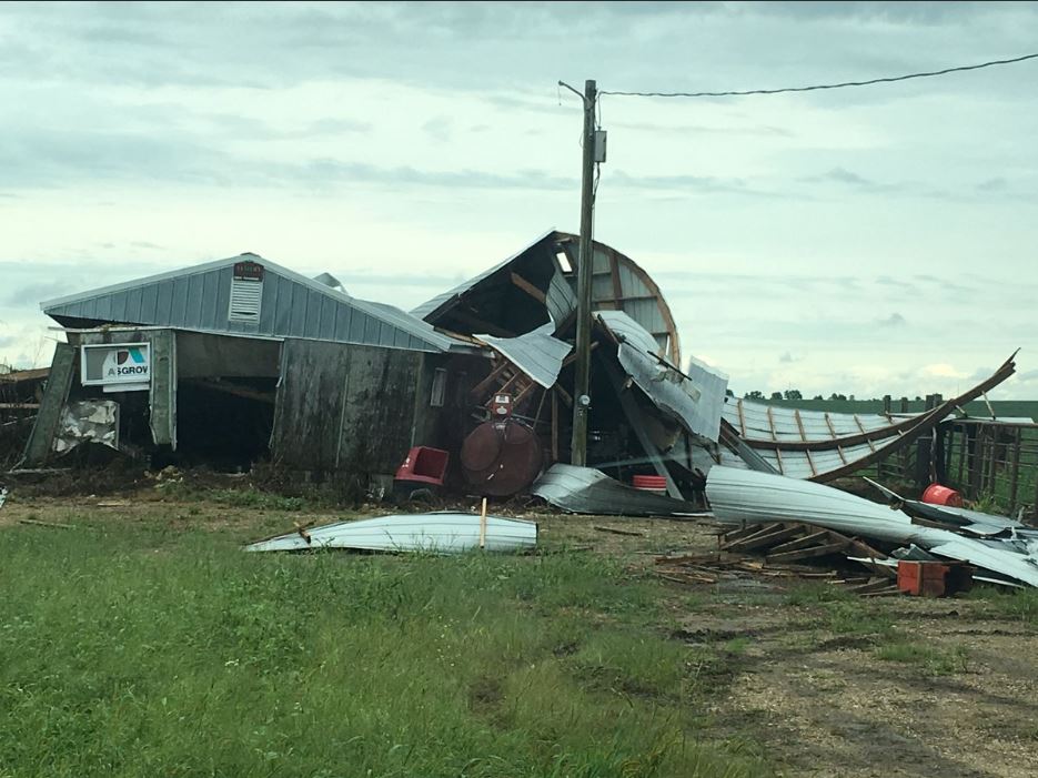
Barn blown down by Racine, MN. (Photo used with permission by Marissa Collins) |
 |
|||
| Barn blown down by Racine, MN. (Photo used with permission by Marissa Collins) |
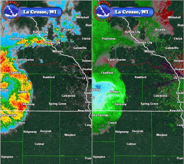
Radar / Satellite:
 |
 |
 |
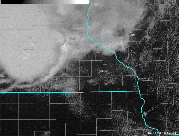 |
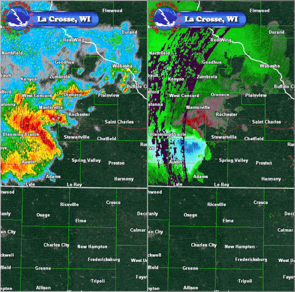
| Rainfall estimates ending 6:00 a.m. Aug.19 | Radar loop showing core of strong winds in green/blue colors. | Radar loop showing storms as they impact Fillmore Co., MN | Rapid-scan satellite imagery showing the tops of the storms. |
Storm Reports
PRELIMINARY LOCAL STORM REPORT...SUMMARY
NATIONAL WEATHER SERVICE LA CROSSE WI
837 PM CDT THU AUG 18 2016

..TIME...   ...EVENT...      ...CITY LOCATION...     ...LAT.LON...
..DATE...   ....MAG....      ..COUNTY LOCATION..ST.. ...SOURCE....
            ..REMARKS..

0443 PM     TSTM WND DMG     9 WNW WALTHAM           43.89N 93.03W
08/18/2016                   DODGE              MN   AMATEUR RADIO

            TREES REPORTED DOWN ALONG COUNTY LINE NEAR
            BLOOMING PRAIRIE.

0455 PM     TSTM WND GST     AUSTIN                  43.67N 92.97W
08/18/2016  M43 MPH          MOWER              MN   AWOS


0455 PM     TSTM WND DMG     AUSTIN                  43.67N 92.97W
08/18/2016                   MOWER              MN   BROADCAST MEDIA

            LARGE TREE UPROOTED.

0458 PM     TSTM WND DMG     1 S MAPLEVIEW           43.68N 92.98W
08/18/2016                   MOWER              MN   911 CALL CENTER

            LARGE BRANCHES DOWN.

0510 PM     TSTM WND GST     4 N SPRING VALLEY       43.74N 92.39W
08/18/2016  E40 MPH          FILLMORE           MN   EMERGENCY MNGR


0511 PM     HAIL             HAYFIELD                43.89N 92.85W
08/18/2016  E0.25 INCH       DODGE              MN   EMERGENCY MNGR


0517 PM     HAIL             KASSON                  44.03N 92.75W
08/18/2016  E0.25 INCH       DODGE              MN   AMATEUR RADIO


0523 PM     TSTM WND GST     HAYFIELD                43.89N 92.85W
08/18/2016  E60 MPH          DODGE              MN   EMERGENCY MNGR


0524 PM     HAIL             1 SW ROCK DELL          43.91N 92.65W
08/18/2016  E0.25 INCH       OLMSTED            MN   FIRE DEPT/RESCUE

            PLUS WIND GUSTS OF 30 MPH.

0524 PM     TSTM WND DMG     3 WNW SPRING VALLEY     43.70N 92.45W
08/18/2016                   MOWER              MN   EMERGENCY MNGR

            LOTS OF TREES BLOWN DOWN.

0524 PM     TSTM WND GST     LE ROY                  43.51N 92.51W
08/18/2016  E40 MPH          MOWER              MN   FIRE DEPT/RESCUE


0532 PM     TSTM WND GST     1 SW ROCK DELL          43.91N 92.65W
08/18/2016  E60 MPH          OLMSTED            MN   AMATEUR RADIO


0544 PM     HAIL             1 SE CHERRY GROVE       43.58N 92.28W
08/18/2016  M1.00 INCH       FILLMORE           MN   TRAINED SPOTTER


0549 PM     TSTM WND GST     STEWARTVILLE            43.86N 92.49W
08/18/2016  E50 MPH          OLMSTED            MN   BROADCAST MEDIA


0600 PM     HEAVY RAIN       HAYFIELD                43.89N 92.85W
08/18/2016  M1.67 INCH       DODGE              MN   PUBLIC

            1.67 INCHES OF RAIN IN 45 MINUTES.

0603 PM     TSTM WND GST     2 WSW FILLMORE          43.74N 92.31W
08/18/2016  M47 MPH          FILLMORE           MN   COCORAHS

            SMALL TREE LIMBS DOWN.

0608 PM     TSTM WND DMG     1 NE CARIMONA           43.67N 92.14W
08/18/2016                   FILLMORE           MN   AMATEUR RADIO

            LOTS OF TREE DAMAGE ON SECONDARY ROADS WEST
            OF PRESTON.

0609 PM     TSTM WND GST     1 NW CARIMONA           43.68N 92.18W
08/18/2016  M73 MPH          FILLMORE           MN   TRAINED SPOTTER

            MEASURED AT THE FILLMORE COUNTY AIRPORT.

0613 PM     TSTM WND GST     RUSHFORD                43.81N 91.75W
08/18/2016  E65 MPH          FILLMORE           MN   TRAINED SPOTTER

            TREES AND POWER LINES DOWN.

0618 PM     TSTM WND GST     1 NE CARIMONA           43.67N 92.14W
08/18/2016  M48 MPH          FILLMORE           MN   AWOS


0630 PM     TSTM WND GST     6 NW FRANKVILLE         43.25N 91.70W
08/18/2016  M47 MPH          WINNESHIEK         IA   MESONET

            MESONET STATION 5 NW FRANKVILLE /RDCI4/.

0630 PM     NON-TSTM WND GST 6 NW FRANKVILLE         43.25N 91.70W
08/18/2016  M47 MPH          WINNESHIEK         IA   MESONET

            MESONET STATION 5 NW FRANKVILLE /RDCI4/.

0645 PM     TSTM WND GST     3 WSW LA CRESCENT       43.81N 91.36W
08/18/2016  M40 MPH          HOUSTON            MN   BROADCAST MEDIA

            REPORTED AT WXOW STUDIOS.

0654 PM     TSTM WND GST     3 W LA CRESCENT         43.83N 91.36W
08/18/2016  M41 MPH          HOUSTON            MN   AMATEUR RADIO


0710 PM     TSTM WND GST     EITZEN                  43.51N 91.46W
08/18/2016  E50 MPH          HOUSTON            MN   TRAINED SPOTTER


0715 PM     TSTM WND GST     PRAIRIE DU CHIEN        43.04N 91.14W
08/18/2016  M49 MPH          CRAWFORD           WI   AWOS


0717 PM     TSTM WND GST     3 WSW LA CRESCENT       43.81N 91.36W
08/18/2016  E40 MPH          HOUSTON            MN   BROADCAST MEDIA


0730 PM     TSTM WND GST     BOSCOBEL                43.14N 90.70W
08/18/2016  M52 MPH          GRANT              WI   ASOS


0754 PM     HEAVY RAIN       3 S NEW HARTFORD        43.83N 91.48W
08/18/2016  M2.14 INCH       HOUSTON            MN   PUBLIC

            STORM TOTAL.
Peak Wind Reports
Public Information Statement
National Weather Service La Crosse WI
616 AM CDT Fri Aug 19 2016

...Peak Wind Reports Over Last 24 Hours...

Location                     Speed     Time/Date
Boscobel Airport             52 MPH    0730 PM 08/18
Prairie Du Chien  Airport    49 MPH    0715 PM 08/18
Preston Airport              48 MPH    0601 PM 08/18
5 NW Frankville              47 MPH    0630 PM 08/18
1 ENE Dexter                 45 MPH    0531 PM 08/18
2 E Kasson                   44 MPH    0240 AM 08/19
Austin Municipal Airport     43 MPH    0455 PM 08/18
1 ENE Boscobel               43 MPH    0803 PM 08/18
Mayo Helipad                 40 MPH    0314 AM 08/19
3 N Stewartville             37 MPH    0530 PM 08/18
1 E Ridgeway                 36 MPH    0650 PM 08/18
3 W Saint Joseph             34 MPH    0715 PM 08/18
Decorah Municipal Airport    33 MPH    0635 PM 08/18
Rochester International Airp 33 MPH    0559 PM 08/18
3 NE Riceville               32 MPH    0546 PM 08/18
Viroqua Municipal Airport    32 MPH    0515 AM 08/19
Oelwein Municipal Airport    32 MPH    0815 PM 08/18
Winona Municipal Airport     32 MPH    0353 AM 08/19
2 NNE Tamarack               32 MPH    0408 AM 08/19
Volk Field                   31 MPH    0529 AM 08/19
Platteville Municipal Airpor 30 MPH    0835 PM 08/18
La Crosse Regional Airport   30 MPH    0423 AM 08/19
Dodge Center Airport         30 MPH    0233 AM 08/19
2 SE Eyota                   29 MPH    0320 AM 08/19
Sparta/Fort McCoy Airport    29 MPH    0455 AM 08/19
Charles City Airport         29 MPH    0615 PM 08/18
Medford Airport              28 MPH    0535 AM 08/19
Fayette-CWOP                 27 MPH    0704 PM 08/18
Necedah                      26 MPH    0548 AM 08/19
4 ESE Douglas                26 MPH    0535 PM 08/18
WFO La Crosse                26 MPH    0525 AM 08/19
De Soto                      26 MPH    0656 PM 08/18
Byron                        25 MPH    0245 AM 08/19
1 SW Mount Sterling          25 MPH    0804 PM 08/18

Observations are collected from a variety of sources with varying
equipment and exposures. Not all data listed are considered official.
Rain Reports from August 18-19
Public Information Statement
National Weather Service La Crosse WI
1205 PM CDT Fri Aug 19 2016

...Rainfall Reports...

Location                     Amount    Time/Date       Lat/Lon

...Iowa...

...Allamakee County...
4 ENE Watson                 1.90 in   1145 AM 08/19   43.11N/91.26W
3 SE Waterville              1.71 in   1107 AM 08/19   43.17N/91.24W
Harpers Ferry                1.20 in   0620 AM 08/19   43.20N/91.15W
3 S Dorchester               0.68 in   1100 AM 08/19   43.42N/91.51W

...Chickasaw County...
New Hampton                  0.28 in   0655 AM 08/19   43.06N/92.32W
Ionia 2W                     0.27 in   1145 AM 08/19   43.03N/92.50W
New Hampton                  0.18 in   0700 AM 08/19   43.06N/92.32W
New Hampton                  0.10 in   0700 AM 08/19   43.06N/92.31W

...Clayton County...
Volga 1NE                    2.86 in   0600 AM 08/19   42.81N/91.52W
Elkader Turkey River         2.63 in   1145 AM 08/19   42.84N/91.40W
Marquette                    2.33 in   0800 AM 08/19   43.05N/91.18W
Littleport                   2.14 in   1145 AM 08/19   42.75N/91.37W
Clayton Center               1.80 in   0711 AM 08/19   42.89N/91.33W
Edgewood                     0.81 in   0600 AM 08/19   42.65N/91.40W
Mcgregor 2                   0.76 in   1145 AM 08/19   43.02N/91.17W
Marquette-Bloody Run Creek   0.61 in   1100 AM 08/19   43.04N/91.21W
Guttenberg Dam 10            0.53 in   0600 AM 08/19   42.78N/91.10W
Monona WWTP                  0.52 in   0700 AM 08/19   43.04N/91.40W

...Fayette County...
1 ENE Alpha                  1.06 in   0700 AM 08/19   43.01N/92.03W
Eldorado                     1.00 in   1145 AM 08/19   43.05N/91.81W
Fayette                      0.74 in   0700 AM 08/19   42.85N/91.82W
Waucoma 1WNW                 0.41 in   0700 AM 08/19   43.06N/92.05W
Oelwein Municipal Airport    0.07 in   0655 AM 08/19   42.68N/91.97W

...Floyd County...
Charles City-Cedar River     0.33 in   1130 AM 08/19   43.06N/92.67W
Colwell                      0.08 in   0700 AM 08/19   43.16N/92.59W
Charles City Airport         0.06 in   0655 AM 08/19   43.07N/92.61W
Charles City                 0.04 in   0700 AM 08/19   43.06N/92.67W

...Howard County...
3 NE Riceville               0.77 in   1148 AM 08/19   43.40N/92.50W
Elma                         0.55 in   0700 AM 08/19   43.24N/92.44W
Cresco 1NE                   0.50 in   0700 AM 08/19   43.39N/92.09W

...Mitchell County...
Riceville                    0.79 in   0846 AM 08/19   43.37N/92.55W
St Ansgar                    0.15 in   0630 AM 08/19   43.38N/92.92W

...Winneshiek County...
Fort Atkinson                0.93 in   0700 AM 08/19   43.14N/91.93W
7 ENE Decorah                0.91 in   0730 AM 08/19   43.34N/91.64W
5 ESE Decorah                0.75 in   0700 AM 08/19   43.26N/91.70W
Decorah Municipal Airport    0.59 in   0655 AM 08/19   43.28N/91.74W
Bluffton                     0.41 in   1145 AM 08/19   43.41N/91.90W

...Minnesota...

...Dodge County...
Claremont 2.5 SSE            1.31 in   0700 AM 08/19   44.01N/92.99W
Dodge Center Airport         1.03 in   0654 AM 08/19   44.02N/92.83W
2 NE Kasson                  0.89 in   0700 AM 08/19   44.05N/92.72W
2 E Claremont                0.80 in   0800 AM 08/19   44.04N/92.95W

...Fillmore County...
Chatfield                    1.54 in   0700 AM 08/19   43.84N/92.20W
1 W Fillmore                 1.18 in   0800 AM 08/19   43.74N/92.31W
Fillmore                     1.03 in   1130 AM 08/19   43.76N/92.27W
Pilot Mound-Root River       1.02 in   1100 AM 08/19   43.78N/92.03W
Highland 2se                 0.87 in   0700 AM 08/19   43.65N/91.84W
Lanesboro-Root River         0.69 in   1130 AM 08/19   43.72N/91.98W
Preston                      0.66 in   0700 AM 08/19   43.66N/92.08W
3 NE Preston                 0.53 in   0700 AM 08/19   43.71N/92.05W
Whalan 3.3 SSE               0.49 in   0700 AM 08/19   43.69N/91.90W
Lanesboro 2NE                0.41 in   0700 AM 08/19   43.73N/91.94W
Preston 6s                   0.33 in   0930 AM 08/19   43.59N/92.11W
Spring Valley                0.14 in   0700 AM 08/19   43.69N/92.39W

...Houston County...
Hokah WWTP                   1.92 in   0700 AM 08/19   43.76N/91.35W
Mound Prairie                1.72 in   1045 AM 08/19   43.78N/91.45W
La Crescent                  1.69 in   0730 AM 08/19   43.84N/91.31W
Houston                      1.65 in   1145 AM 08/19   43.77N/91.57W
Caledonia                    1.48 in   0700 AM 08/19   43.63N/91.50W
1 NNW La Crescent            1.48 in   0700 AM 08/19   43.83N/91.31W
Spring Grove 4n              0.74 in   0700 AM 08/19   43.61N/91.62W
4 NW Eitzen                  0.57 in   0800 AM 08/19   43.56N/91.51W

...Mower County...
Austin 3 NW - Turtle Creek   0.71 in   1130 AM 08/19   43.65N/92.98W
Austin 3S                    0.68 in   1100 AM 08/19   43.64N/92.97W
Lansing-Cedar River          0.58 in   1130 AM 08/19   43.75N/92.95W
Ostrander 5wnw               0.51 in   0930 AM 08/19   43.63N/92.53W
1 ENE Austin                 0.49 in   0800 AM 08/19   43.68N/92.94W
Austin 2NE-Dobbins Creek     0.48 in   1130 AM 08/19   43.67N/92.95W
Austin Municipal Airport     0.35 in   0656 AM 08/19   43.66N/92.93W
Ostrander 5.1 WNW            0.25 in   0700 AM 08/19   43.65N/92.52W

...Olmsted County...
Rochester Ap 2ne             1.96 in   0700 AM 08/19   43.93N/92.48W
Rochester International Airp 1.84 in   0654 AM 08/19   43.91N/92.50W
Oronoco 1W                   1.19 in   1130 AM 08/19   44.17N/92.55W
Oronoco                      1.15 in   1130 AM 08/19   44.16N/92.54W
Elba 4.7 SW                  1.06 in   0830 AM 08/19   44.04N/92.09W
2 N Rock Dell                0.97 in   0800 AM 08/19   43.96N/92.63W
Rochester-Cascade Creek      0.94 in   1130 AM 08/19   44.03N/92.47W
3 SW Hammond                 0.93 in   1151 AM 08/19   44.18N/92.41W
1 W Chester                  0.91 in   0630 AM 08/19   44.00N/92.38W
2 SE Douglas                 0.80 in   1150 AM 08/19   44.08N/92.55W
4 ESE Douglas                0.78 in   1150 AM 08/19   44.09N/92.49W
Byron                        0.75 in   1140 AM 08/19   44.04N/92.64W
3 NE Rochester               0.73 in   1155 AM 08/19   44.05N/92.45W
5 E Douglas                  0.72 in   1000 AM 08/19   44.10N/92.47W
4 ESE Douglas                0.72 in   0700 AM 08/19   44.08N/92.48W
Byron 4 North                0.68 in   0700 AM 08/19   44.09N/92.64W
Byron                        0.67 in   1151 AM 08/19   44.03N/92.66W
2 ENE Rochester              0.65 in   1130 AM 08/19   44.03N/92.43W
3 N Rochester                0.64 in   1115 AM 08/19   44.06N/92.47W
Oxbow Park Alert Gage        0.62 in   1100 AM 08/19   44.09N/92.64W
Rochester-Beltline           0.61 in   1130 AM 08/19   44.01N/92.47W
Eyota 2NE                    0.61 in   1130 AM 08/19   44.01N/92.20W
2 NE Rochester               0.59 in   0600 AM 08/19   44.04N/92.44W
Rochester-Beltline Bear Cree 0.57 in   1130 AM 08/19   44.01N/92.45W
Mayo Helipad                 0.55 in   0654 AM 08/19   44.02N/92.48W
Rochester 3W                 0.54 in   1130 AM 08/19   44.02N/92.53W
Pine Island 1S               0.54 in   1100 AM 08/19   44.19N/92.65W
3 ESE Douglas                0.54 in   1150 AM 08/19   44.09N/92.51W
4 NNW Rochester              0.53 in   0700 AM 08/19   44.07N/92.49W
2 NE Rochester               0.47 in   1140 AM 08/19   44.04N/92.44W
Elgin 2ssw                   0.42 in   0700 AM 08/19   44.10N/92.27W
Elgin 5SE                    0.33 in   1130 AM 08/19   44.01N/92.11W

...Wabasha County...
Plainview                    0.99 in   1142 AM 08/19   44.17N/92.17W
Lake City                    0.65 in   1146 AM 08/19   44.45N/92.27W
Lake City                    0.55 in   0700 AM 08/19   44.44N/92.28W
Kellogg-Zumbro River         0.51 in   1100 AM 08/19   44.32N/92.00W
1 SSE Lake City              0.41 in   0800 AM 08/19   44.43N/92.27W
Theilman 1SSW                0.36 in   0800 AM 08/19   44.28N/92.19W
Wabasha                      0.31 in   0700 AM 08/19   44.38N/92.05W
2 NNW Zumbro Falls           0.30 in   1149 AM 08/19   44.32N/92.44W
3 SW Zumbro Falls            0.25 in   0755 AM 08/19   44.24N/92.46W
Mazeppa 3ESE                 0.20 in   1130 AM 08/19   44.26N/92.49W

...Winona County...
2 NNW Pickwick               1.81 in   0700 AM 08/19   44.02N/91.61W
La Crescent Dam 7            1.46 in   0600 AM 08/19   43.87N/91.31W
Lewiston                     1.38 in   0700 AM 08/19   43.99N/91.87W
Winona 4S                    1.34 in   0618 AM 08/19   43.99N/91.60W
1 E Winona                   1.31 in   1150 AM 08/19   44.05N/91.63W
Winona Municipal Airport     1.28 in   0654 AM 08/19   44.08N/91.71W
Winona Dam 5A                1.23 in   0600 AM 08/19   44.09N/91.67W
Stockton                     1.17 in   0728 AM 08/19   44.03N/91.77W
Whitewater State Park        1.13 in   1130 AM 08/19   44.05N/92.05W
Stockton                     1.13 in   0700 AM 08/19   44.03N/91.77W
Dakota                       1.09 in   1115 AM 08/19   43.91N/91.36W
Altura 5w                    1.00 in   0700 AM 08/19   44.06N/92.04W
Minnesota City Dam 5         0.99 in   0700 AM 08/19   44.16N/91.81W
Whitewater State Park Group  0.88 in   1130 AM 08/19   44.06N/92.05W
Elba                         0.83 in   1145 AM 08/19   44.09N/92.03W
Beaver-White Water River     0.52 in   1045 AM 08/19   44.15N/92.00W

...Wisconsin...

...Adams County...
Castle Rock                  1.90 in   0715 AM 08/19   43.87N/89.95W
Monroe Center 1E             1.71 in   0700 AM 08/19   44.11N/89.92W
Friendship                   0.78 in   0700 AM 08/19   43.98N/89.83W
2 SE New Rome                0.49 in   0700 AM 08/19   44.21N/89.85W

...Buffalo County...
Alma Dam 4                   0.76 in   0600 AM 08/19   44.33N/91.92W

...Clark County...
Neillsville 1W               0.66 in   1100 AM 08/19   44.56N/90.61W
Neillsville 3ese             0.53 in   0800 AM 08/19   44.54N/90.53W
Owen 2N                      0.23 in   0800 AM 08/19   44.98N/90.55W

...Crawford County...
Prairie Du Chien  Airport    2.45 in   0655 AM 08/19   43.02N/91.12W
Prairie Du Chien             2.33 in   0700 AM 08/19   43.05N/91.13W
Lynxville Dam 9              1.60 in   0600 AM 08/19   43.21N/91.10W
Steuben                      1.37 in   1145 AM 08/19   43.18N/90.86W
1 WNW Mount Zion             1.24 in   0700 AM 08/19   43.26N/90.76W
1 NW Mount Zion              1.24 in   0745 AM 08/19   43.27N/90.75W
Steuben 4SE                  1.05 in   0700 AM 08/19   43.13N/90.84W
Gays Mills                   0.90 in   0800 AM 08/19   43.32N/90.85W
De Soto                      0.55 in   1146 AM 08/19   43.42N/91.19W
De Soto 1SE                  0.50 in   0700 AM 08/19   43.42N/91.19W
Ferryville                   0.39 in   0709 AM 08/19   43.33N/91.07W
Ferryville 1se               0.39 in   0709 AM 08/19   43.33N/91.07W

...Grant County...
Sinsinawa                    1.20 in   0900 AM 08/19   42.52N/90.54W
Cuba City                    0.70 in   0800 AM 08/19   42.60N/90.43W
Platteville                  0.60 in   0637 AM 08/19   42.74N/90.49W
Platteville Municipal Airpor 0.54 in   0655 AM 08/19   42.69N/90.44W
Muscoda                      0.54 in   1145 AM 08/19   43.20N/90.44W
1 ENE Boscobel               0.40 in   1103 AM 08/19   43.15N/90.68W
Boscobel Airport             0.33 in   0653 AM 08/19   43.16N/90.67W

...Jackson County...
Black River Falls Area Airpo 1.01 in   0655 AM 08/19   44.25N/90.86W
1 E Black River Falls        0.76 in   1115 AM 08/19   44.30N/90.83W
Black River Falls Sewage     0.74 in   0830 AM 08/19   44.29N/90.85W
Black River Falls 1.7 NNE    0.58 in   0700 AM 08/19   44.32N/90.83W
Hatfield Dam                 0.47 in   0822 AM 08/19   44.41N/90.73W
Black River Falls-black Rive 0.21 in   0715 AM 08/19   44.28N/90.87W

...Juneau County...
3 SE Necedah                 3.25 in   1158 AM 08/19   43.99N/90.03W
Mauston                      2.89 in   1152 AM 08/19   43.80N/90.07W
Necedah                      2.48 in   1148 AM 08/19   44.03N/90.08W
Volk Field                   2.35 in   0658 AM 08/19   43.94N/90.25W
2 WNW Dellwood               2.26 in   1150 AM 08/19   44.00N/89.99W
2 WNW Wisconsin Dells        2.23 in   1140 AM 08/19   43.65N/89.82W
2 N Cloverdale               1.90 in   1110 AM 08/19   44.06N/90.17W
Mauston Airport              1.57 in   0655 AM 08/19   43.84N/90.14W

...La Crosse County...
5 SE La Crosse               2.69 in   0800 AM 08/19   43.77N/91.17W
La Crosse                    2.12 in   1200 PM 08/19
La Crosse 4NNW               1.63 in   0730 AM 08/19   43.87N/91.27W
Melrose 8.2 SSW              1.60 in   0800 AM 08/19   44.02N/91.06W
Newburg Corners              1.60 in   0845 AM 08/19   43.78N/90.98W
La Crosse Weather Office     1.40 in   0600 AM 08/19   43.82N/91.19W
La Crosse Regional Airport   1.29 in   0653 AM 08/19   43.88N/91.26W
Onalaska 2n                  1.21 in   0800 AM 08/19   43.91N/91.23W
1 NW Onalaska                1.20 in   0846 AM 08/19   43.90N/91.23W
West Salem                   0.93 in   0700 AM 08/19   43.90N/91.09W
West Salem 2w                0.77 in   0700 AM 08/19   43.90N/91.12W

...Monroe County...
Cataract                     4.25 in   0530 AM 08/19   44.08N/90.85W
Warrens 4WSW                 3.95 in   0700 AM 08/19   44.10N/90.59W
2 E Cataract                 2.92 in   1153 AM 08/19   44.09N/90.79W
Fort Mccoy- Stillwell Creek  2.32 in   0710 AM 08/19   44.00N/90.68W
Sparta                       2.28 in   0800 AM 08/19   43.94N/90.82W
4 W Valley Junction          2.06 in   0700 AM 08/19   44.06N/90.50W
Tunnel City                  1.79 in   0700 AM 08/19   44.01N/90.57W
Sparta/Fort McCoy Airport    1.67 in   0655 AM 08/19   43.96N/90.74W
Kendall                      1.42 in   1120 AM 08/19   43.79N/90.37W
Melvina                      0.96 in   0700 AM 08/19   43.81N/90.76W
3 WNW Kendall                0.91 in   0700 AM 08/19   43.81N/90.44W
Cashton 3NNW                 0.52 in   0752 AM 08/19   43.79N/90.80W

...Richland County...
Richland Center 4N           1.23 in   0700 AM 08/19   43.40N/90.39W
3 NW Avoca                   0.80 in   1107 AM 08/19   43.23N/90.37W

...Taylor County...
Jump River 1 NW              0.61 in   0815 AM 08/19   45.36N/90.80W
Westboro 4E                  0.30 in   0700 AM 08/19   45.35N/90.22W
3 NE Lublin                  0.23 in   1114 AM 08/19   45.11N/90.69W
Chelsea                      0.15 in   1151 AM 08/19   45.30N/90.30W
Medford                      0.14 in   0800 AM 08/19   45.13N/90.34W
Medford Airport              0.12 in   0655 AM 08/19   45.10N/90.30W

...Trempealeau County...
1 WSW York                   2.20 in   1006 AM 08/19   44.44N/91.17W
Whitehall                    2.00 in   0713 AM 08/19   44.37N/91.31W
2 ENE Elk Creek              1.75 in   0742 AM 08/19   44.44N/91.35W
Dodge                        1.66 in   1145 AM 08/19   44.13N/91.55W
Ettrick 4WNW                 1.61 in   0630 AM 08/19   44.19N/91.34W
Trempealeau Dam 6            1.17 in   0600 AM 08/19   44.00N/91.44W
1 NW Trempealeau             1.04 in   0630 AM 08/19   44.03N/91.46W

...Vernon County...
Genoa Dam 8                  1.65 in   0600 AM 08/19   43.57N/91.23W
Viroqua Municipal Airport    1.50 in   0655 AM 08/19   43.58N/90.90W
Viroqua                      1.45 in   0700 AM 08/19   43.56N/90.88W
Ontario 3e                   1.23 in   0700 AM 08/19   43.72N/90.53W
Readstown                    1.20 in   1100 AM 08/19   43.45N/90.76W
Stoddard                     1.11 in   0700 AM 08/19   43.66N/91.22W
Hillsboro WSW                1.05 in   0700 AM 08/19   43.65N/90.35W
Ontario                      1.00 in   1100 AM 08/19   43.72N/90.59W
Westby 3ENE                  0.89 in   0700 AM 08/19   43.67N/90.81W
Brownsville                  0.83 in   1145 AM 08/19   43.70N/91.27W
La Farge                     0.82 in   0715 AM 08/19   43.57N/90.64W
Hillsboro 2sw                0.78 in   0700 AM 08/19   43.63N/90.38W
3 WNW Viola                  0.66 in   0830 AM 08/19   43.53N/90.74W
Readstown 4NE                0.64 in   0700 AM 08/19   43.48N/90.69W

Observations are collected from a variety of sources with varying
equipment and exposures. Not all data listed are considered official.
 |
Media use of NWS Web News Stories is encouraged! Please acknowledge the NWS as the source of any news information accessed from this site. |
|


 Weather Story
 Weather Map
 Local Radar