Albuquerque, NM
Weather Forecast Office
Winter Weather Awareness |
Staying Safe |
Mantenerse Seguro |
Winter Products |
Cold Season Precipitation Types |
Climatology |
| Snow Climatology | |
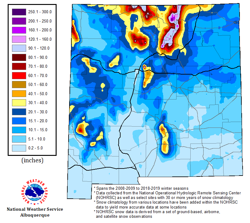
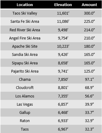
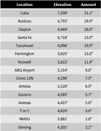
| The snowfall map below was created using a variety of data sets with ArcMap. A base map was constructed using snowfall analysis from the National Operational Hydrologic Remote Sensing Center (NOHRSC) averaging the 2008-2009 to 2018-2019 winter seasons. NOHRSC snowfall data is derived from a set a ground-based, airborne, and satellite snowfall observations. Numerous data points from airports and cooperative observer stations were added to the analysis to yield a more representative 30-year climatology from 1981-2010. Ski sites were also included in the analysis to highlight the considerable variation and more extreme snowfall amounts across the rugged terrain of New Mexico. Click on the image for a larger map. The table provided below the map details point specific averages. | |
|
|
|
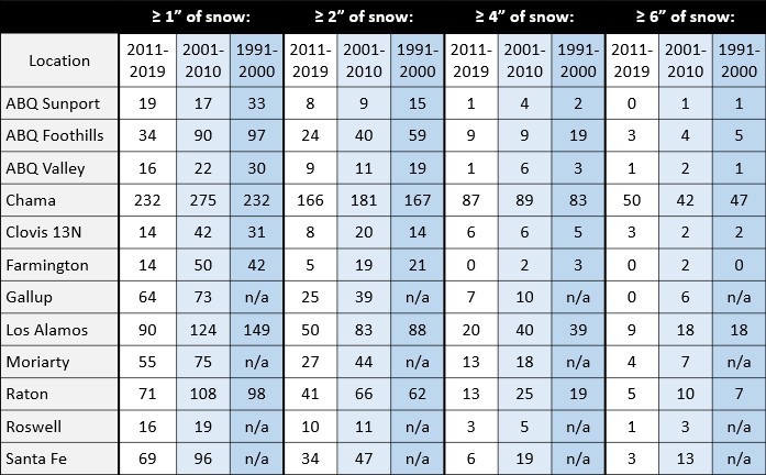
Frequency of Snow Events Across Northern & Central New Mexico
(Number of Days) |
|
| The table below outlines the frequency of 1"+, 2"+, 4"+, and 6"+ snowfall events by number of days at select locations across northern and central NM for the most recent three decades. | |
|
|
|
Current Hazards
Outlooks
Submit A Storm Report
Severe and Hazardous Weather Info
Current Conditions
Surface Observations
Observed Precipitation
Satellite
Local Satellite Page
Local Observations Page
Map of Latest Wind and Precipitation Reports
Radar
National Radar
ABX Albuquerque Radar
FDX Cannon Air Force Base Radar
Forecasts
Fire Weather Forecasts
Area Forecast Discussion
Hourly View Forecast
Activity Planner
Aviation Forecasts
Local Forecast Page
Graphical Forecasts
Hydrology
Advanced Hydrologic Prediction Services
Local Hydrology Products
Climate and Past Weather
Climate Graphs
Drought
Severe T-Storm Climatology for NM
Local Data
Winter Climatology for NM
NOAA Climate Center
Climate Prediction Center
Local Programs
About Our Office
SKYWARN
NOAA Weather Radio
Local Studies and Features
Winter Weather Info, Safety Tips, and Climo
Severe Weather Info, Safety Tips, and Climo
Center Weather Service Unit
US Dept of Commerce
National Oceanic and Atmospheric Administration
National Weather Service
Albuquerque, NM
2341 Clark Carr Loop SE
Albuquerque, NM 87106-5633
(505) 243-0702
Comments? Questions? Please Contact Us.