
Tropical Depression Two is expected to gradually strengthen and could bring tropical storm conditions to the Florida Panhandle beginning late Monday. Areas of flash flooding will be possible through Thursday along the eastern and central Gulf Coast. Severe thunderstorms will develop and move along a cold front crossing the Upper Midwest Monday, and through the Ohio Valley/Mid-Atlantic on Tuesday. Read More >
Overview
|
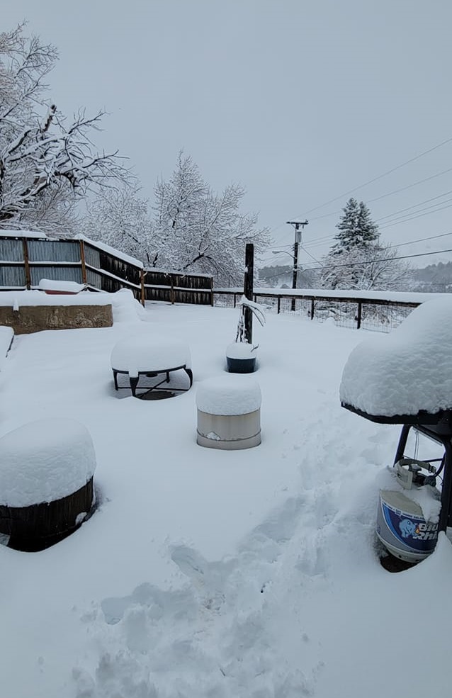
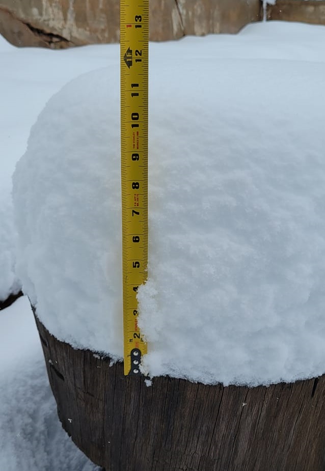
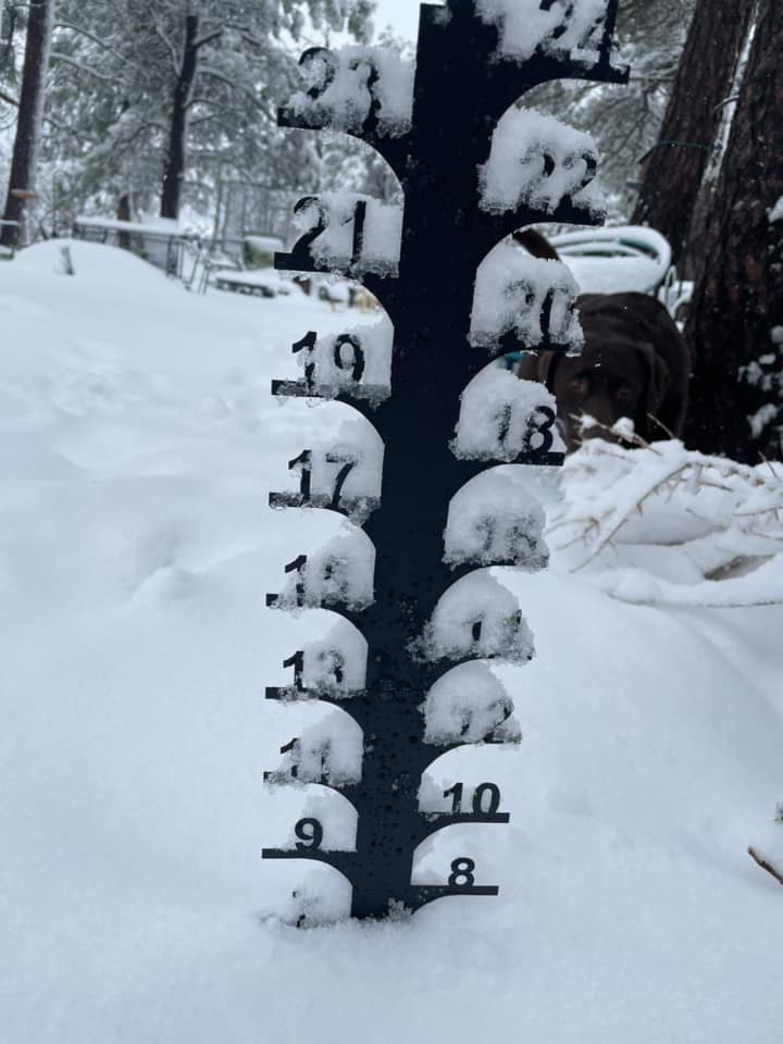
A strong spring storm brought abundant moisture and strong winds to the Black Hills region on April 6-8, 2024. As the storm moved into the area, strong winds in excess of 50 mph were common over northeastern Wyoming and southwestern South Dakota. A 58 mph wind gust was reported seven miles west of Ardmore, SD. Throughout the storm, gusty winds created blowing and drifting snow over a large portion of northeastern WY, which closed roads and made travel difficult. Snowfall amounts around a foot were reported over the higher Black Hills and Campbell County, WY. The heavy, wet snow was very elevation-dependent, with snowfall totals in Spearfish ranging from an inch or two to over 8 inches. Even in Box Elder and New Underwood, some residents woke up to over four inches of snow covering the ground, while the Rapid City area only had a little snow accumulation. Over two inches of rain and snow liquid equivalent were reported in the Black Hills and eastern foothills. At the NWS office in Rapid City, 1.98 inches of precipitation was reported, with only a trace of snow. |
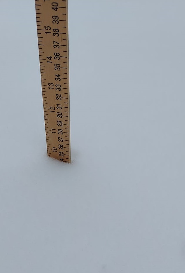
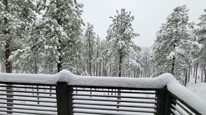 3 SE Spearfish (Deana Wiese) |
Photos & Video
Header
 |
 |
 |
 |
| Lead (Jessica Borgstadt) |
Lead (Jessica Borgstadt) |
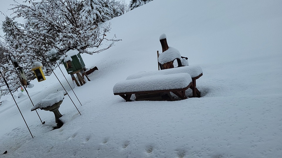
West Spearfish (Julie Reinert) |
Spearfish Green Acres (Jessica Stanton) |
 |
 |
||
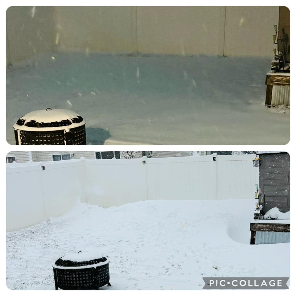
| Gillette April 6 (top) and April 7 (bottom) (Beth Raab) |
Spearfish (Kathy Kruskamp) |
Radar
Radar Loop from 10 AM April 6 to 10 AM April 7, 2024
Radar Loop from 10 AM April 7 to 10 AM April 8, 2024
Storm Reports
...PRELIMINARY SNOW AND SLEET TOTALS (AT LEAST 1.0 INCH) SORTED BY MAGNITUDE...

LOCATION                      SNOWFALL    COMMENTS
                               IN/S/

6 SW Brownsville SD            18.0       1200 PM 4/08/2024
Lead SD                        13.5        900 AM 4/08/2024
4 SE Gillette WY               13.0        530 PM 4/08/2024
1 W O`Neil Pass SD             13.0        118 PM 4/08/2024
3 ESE Cheyenne Crossing SD     12.8        700 AM 4/08/2024
1 SW Deadwood SD               12.0       1037 AM 4/08/2024
6 NNE Custer SD                12.0        200 PM 4/07/2024
19 NNW New Haven WY            12.0       1254 PM 4/08/2024
8 NW Rockypoint WY             12.0        108 PM 4/08/2024
Wright WY                      11.8       1026 AM 4/08/2024
11 NNE Weston WY                9.0        700 AM 4/07/2024
5 N Rochford SD                 9.0       1023 AM 4/08/2024
Brownsville SD                  8.5       1000 AM 4/08/2024
2 ESE Dwtn Spearfish SD         8.0       1245 PM 4/07/2024
3 SE Dwtn Spearfish SD          8.0       1003 AM 4/08/2024
8 WSW Rozet WY                  7.6        700 AM 4/08/2024
3 W Dwtn Spearfish SD           7.0       1200 PM 4/07/2024
Nemo SD                         7.0       1000 AM 4/08/2024
3 SE Whitewood SD               7.0        610 PM 4/08/2024
7 WSW Aladdin WY                6.0        109 PM 4/08/2024
Dwtn Gillette WY                6.0        823 AM 4/07/2024
8 NNW Newcastle WY              5.5        700 AM 4/08/2024
Box Elder SD                    5.5        900 AM 4/07/2024
5 ENE Custer SD                 5.4        700 AM 4/07/2024
2 NNW Saint Onge SD             5.0       1130 AM 4/08/2024
1 NW Whitewood SD               4.5       1200 PM 4/07/2024
4 NNW Tilford SD                4.0        700 AM 4/07/2024
2 N Four Corners WY             4.0        123 PM 4/08/2024
Pine Haven WY                   4.0       1253 PM 4/08/2024
Dwtn Spearfish SD               3.5        637 AM 4/07/2024
3 SE Saint Onge SD              3.5        530 AM 4/07/2024
4 SE Upton WY                   3.4        700 AM 4/08/2024
14 NNW Dwtn Gillette WY         3.2        700 AM 4/07/2024
1 ESE Pactola Resv SD           3.2        900 AM 4/07/2024
7 SSE Bison SD                  3.0        620 AM 4/08/2024
3 NE Whitewood SD               3.0        735 PM 4/07/2024
6 W New Underwood SD            3.0        700 AM 4/07/2024
2 WNW Dwtn Spearfish SD         3.0        700 AM 4/08/2024
Dupree SD                       3.0        700 PM 4/07/2024
6 SW Beulah WY                  3.0        800 AM 4/08/2024
1 N Dwtn Spearfish SD           2.5        200 PM 4/07/2024
Sundance WY                     2.2        600 AM 4/08/2024
3 NE Hisega SD                  1.8        700 AM 4/08/2024
Hill City SD                    1.8        700 AM 4/07/2024
3 NNE Johnson Siding SD         1.5        700 AM 4/08/2024
4 NNE Johnson Siding SD         1.5        800 AM 4/07/2024
7 NNE Ellsworth AFB SD          1.3        600 AM 4/07/2024
1 NNW Dwtn Spearfish SD         1.2       1000 AM 4/08/2024
9 WSW Red Elm SD                1.0        646 AM 4/08/2024
Lemmon SD                       1.0        600 PM 4/07/2024
1 WNW Clareton WY               1.0        700 AM 4/07/2024
3 SSE Harding SD                1.0        900 AM 4/07/2024
1 ESE Newcastle WY              1.0        900 AM 4/08/2024
8 WNW Usta SD                   1.0        700 AM 4/08/2024


...PRELIMINARY RAINFALL TOTALS (AT LEAST 0.50 INCH) SORTED BY MAGNITUDE...

LOCATION                      TOTAL RAIN  COMMENTS
                               IN/S/

Lead SD                        3.14        900 AM 4/08/2024
2 NNW Saint Onge SD            3.05       1130 AM 4/08/2024
Tilford SD                     2.97        700 AM 4/08/2024
Piedmont SD                    2.82        823 AM 4/08/2024
3 NE Whitewood SD              2.70        700 PM 4/08/2024
4 NNE Johnson Siding SD        2.70        800 AM 4/07/2024
3 SSW Dwtn Rapid City SD       2.65       1220 PM 4/07/2024
1 NNW Piedmont SD              2.58       1258 AM 4/08/2024
4 N Johnson Siding SD          2.55        700 AM 4/07/2024
4 NNW Tilford SD               2.53        800 AM 4/08/2024
Keystone SD                    2.49        735 AM 4/07/2024
4 NW Dwtn Rapid City SD        2.44        700 AM 4/08/2024
1 SSW Box Elder SD             2.30        700 AM 4/08/2024
2 WNW Dwtn Spearfish SD        2.27        700 AM 4/08/2024
6 S Hermosa SD                 2.25        900 AM 4/07/2024
9 NNE Sturgis SD               2.25        700 AM 4/07/2024
6 NNW Dwtn Spearfish SD        2.24        700 AM 4/08/2024
5 ENE Custer SD                2.17        700 AM 4/07/2024
Nemo SD                        2.17        921 AM 4/07/2024
3 ESE Cheyenne Crossing SD     2.14        700 AM 4/08/2024
Box Elder SD                   2.14        900 AM 4/07/2024
1 ESE Pactola Resv SD          2.13        900 AM 4/07/2024
4 W Rapid City SD              2.13        921 AM 4/07/2024
6 NE Summerset SD              2.10        921 AM 4/07/2024
2 ENE Sheridan Lake SD         2.08        921 AM 4/07/2024
Hill City SD                   2.06        700 AM 4/07/2024
2 N Summerset SD               2.00        921 AM 4/07/2024
3 E Wasta SD                   1.99        700 AM 4/08/2024
3 SE Nisland SD                1.93        130 PM 4/08/2024
Rapid City Arpt SD             1.93        921 AM 4/07/2024
7 E Sturgis SD                 1.86        921 AM 4/07/2024
Mount Rushmore SD              1.85       1258 AM 4/08/2024
8 W Belle Fourche SD           1.80        800 AM 4/07/2024
2 E Sturgis SD                 1.78        700 PM 4/08/2024
1 S Belle Fourche SD           1.77        830 AM 4/08/2024
8 WNW Fairburn SD              1.76        921 AM 4/07/2024
6 W New Underwood SD           1.64        700 AM 4/07/2024
8 ENE Alva WY                  1.63        700 AM 4/08/2024
5 WNW Hermosa SD               1.57       1200 PM 4/07/2024
1 E Lead SD                    1.57        921 AM 4/07/2024
7 WSW Fairburn SD              1.54        945 AM 4/07/2024
3 W Scenic SD                  1.46        700 AM 4/08/2024
3 SE Spearfish SD              1.42        921 AM 4/07/2024
2 E Vale SD                    1.40        700 AM 4/07/2024
Newell SD                      1.30        900 AM 4/08/2024
1 WNW Caputa SD                1.26        921 AM 4/07/2024
5 SW Brownsville SD            1.25        921 AM 4/07/2024
1 NNW Nisland SD               1.23        921 AM 4/07/2024
3 ENE Kyle SD                  1.20        700 AM 4/08/2024
Hot Springs SD                 1.17        700 AM 4/08/2024
1 W Wind Cave Visitors Center  1.12        921 AM 4/07/2024
6 SW Beulah WY                 1.10        800 AM 4/08/2024
Oral SD                        1.08        700 AM 4/08/2024
4 SE Gillette WY               0.98        530 PM 4/08/2024
4 W Hot Springs SD             0.96        700 AM 4/08/2024
4 S New Underwood SD           0.96        900 AM 4/07/2024
27 WNW Castle Rock SD          0.96        921 AM 4/07/2024
12 S Quinn SD                  0.95        800 AM 4/08/2024
8 WSW Rozet WY                 0.93        700 AM 4/08/2024
4 SSE Devils Tower WY          0.93        730 AM 4/08/2024
11 NNE Weston WY               0.90        700 AM 4/07/2024
1 NW Dwtn Spearfish SD         0.89        800 AM 4/08/2024
2 SSW Oral SD                  0.84        921 AM 4/07/2024
5 NE Porcupine SD              0.83        921 AM 4/07/2024
12 WNW Philip SD               0.80        800 AM 4/08/2024
Wright WY                      0.80        700 AM 4/08/2024
2 SSW Custer SD                0.79        921 AM 4/07/2024
6 WNW Union Center SD          0.78        700 AM 4/07/2024
Sundance WY                    0.77        600 AM 4/08/2024
4 SE Upton WY                  0.76        700 AM 4/08/2024
Argyle SD                      0.75        956 AM 4/07/2024
2 WNW Custer SD                0.75        921 AM 4/07/2024
Wasta SD                       0.73        921 AM 4/07/2024
5 NW Swett SD                  0.70        800 AM 4/08/2024
11 SE Potato Creek SD          0.70        700 AM 4/08/2024
3 SSE Harding SD               0.69        900 AM 4/08/2024
8 S Wall SD                    0.68        921 AM 4/07/2024
2 ENE Edgemont SD              0.65        700 AM 4/08/2024
14 S Mission SD                0.65        700 AM 4/08/2024
8 E Martin SD                  0.65        700 AM 4/08/2024
3 ESE Pine Ridge SD            0.64        921 AM 4/07/2024
8 NW Vetal SD                  0.63        600 AM 4/08/2024
3 WNW Kadoka SD                0.62        500 AM 4/09/2024
1 WSW South Eagle Butte SD     0.61        921 AM 4/07/2024
16 SSE Mission SD              0.61        600 AM 4/08/2024
7 N Wood SD                    0.60        600 AM 4/08/2024
5 ESE Norris SD                0.60        831 AM 4/08/2024
3 SE Saint Onge SD             0.59        515 AM 4/08/2024
9 SE Meadow SD                 0.58        700 AM 4/08/2024
7 N Kirley SD                  0.58        700 AM 4/08/2024
1 WSW Newcastle WY             0.57        700 AM 4/08/2024
3 E Midland SD                 0.56        700 AM 4/08/2024
Lemmon SD                      0.56        600 PM 4/07/2024
1 SSE Dwtn Spearfish SD        0.54        800 AM 4/08/2024
7 W Ardmore SD                 0.54        921 AM 4/07/2024
2 W Moorcroft WY               0.53        700 AM 4/07/2024
9 N Cedar Butte SD             0.53        600 AM 4/08/2024
4 W Custer SD                  0.52        921 AM 4/07/2024
8 ESE Prairie City SD          0.51        700 AM 4/08/2024
12 NNW White River SD          0.51        700 AM 4/07/2024
Union Center SD                0.51        921 AM 4/07/2024
5 NE Milesville SD             0.50        700 PM 4/07/2024
Dupree SD                      0.50        700 PM 4/07/2024
9 SSE Sorum SD                 0.50        700 AM 4/08/2024


...MAXIMUM OBSERVED WINDS (AT LEAST 50 MPH) SORTED BY MAGNITUDE...

LOCATION                      MAX WIND    COMMENTS
                               MPH

7 W Ardmore SD                   58        115 AM 4/07/2024
25 ESE Wright WY                 54        105 AM 4/07/2024
3 ESE Pine Ridge SD              53        648 AM 4/06/2024
17 WSW Wright WY                 53       1242 AM 4/07/2024
5 NNW Dwtn Gillette WY           53        355 AM 4/07/2024
1 NE Winner SD                   52        324 PM 4/06/2024
1 NE Echeta WY                   52        451 AM 4/07/2024
 |
Media use of NWS Web News Stories is encouraged! Please acknowledge the NWS as the source of any news information accessed from this site. |
|

