
Tropical Depression Two is expected to gradually strengthen and could bring tropical storm conditions to the Florida Panhandle beginning late Monday. Areas of flash flooding will be possible through Thursday along the eastern and central Gulf Coast. Severe thunderstorms will develop and move along a cold front crossing the Upper Midwest Monday, and through the Ohio Valley/Mid-Atlantic on Tuesday. Read More >
Overview
|
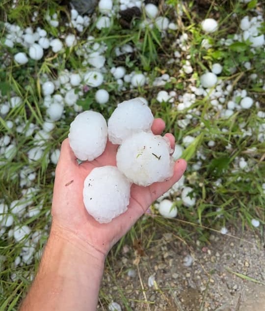
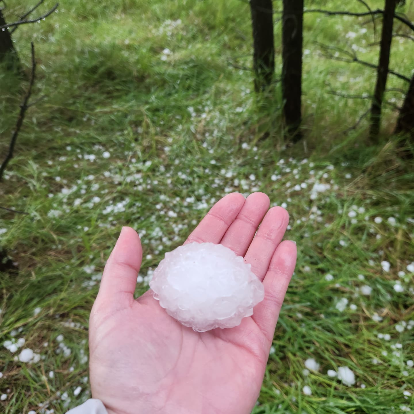
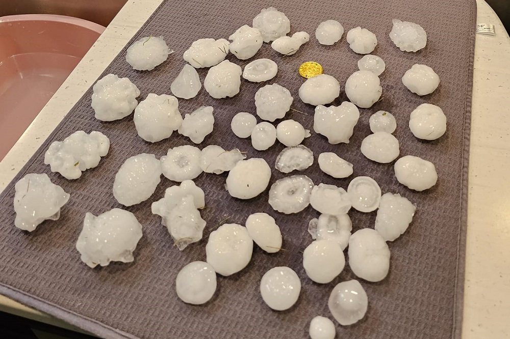
The afternoon of Sunday, July 30th began with a potent supercell that developed over the Black Hills, dropping baseball sized hail at Pactola Reservoir. As it moved southeastward, over 3 inch hail fell along the Flume Trail. The storm quickly dissipated as it moved off the Black Hills. More severe thunderstorms developed across northeastern WY later in the afternoon and evening, resulting in golf ball sized hail and up to 80 mph winds. The storms expanded into western SD during the evening. |
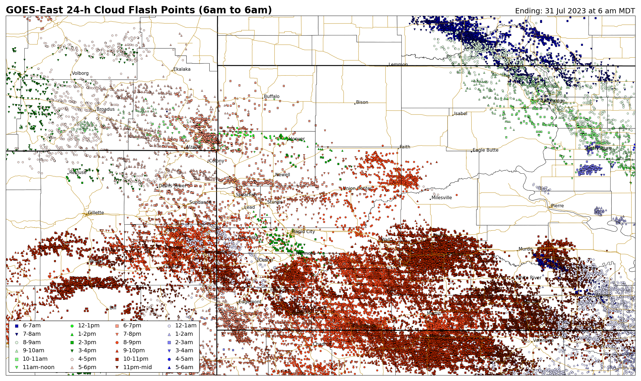 Here is the 24-hour GLM lightning map from 6 am MDT (7/30) to 6 am MDT (7/31). |
Photos
 |
 |
 |
 |
| Pactola (Curtis Coomes) |
Flume Trail (Sharon Samuelson) |
South of Sheridan Lake (Kelsey Rausch) |
South Sundance (Lacey Robinson) |
July 30, 2023 Baseball Hail at Pactola Reservoir (above)
Video Courtesy Karen Linn
July 30, 2023 Tennis Ball Hail at Pactola Reservoir (above)
Video Courtesy Caleb Amos
Storm Reports
...PRELIMINARY RAINFALL TOTALS (AT LEAST 0.50 INCH) SORTED BY MAGNITUDE...

LOCATION                      TOTAL RAIN  COMMENTS
                               IN/S/

13 S INTERIOR SD               3.50       1100 PM 7/30/2023
14 S MISSION SD                2.49        700 AM 7/31/2023
16 SSE MISSION SD              2.37        600 AM 7/31/2023
3 SSW ARGYLE SD                2.34        700 AM 7/31/2023
4 NW PARMELEE SD               2.00        700 AM 7/31/2023
3 NE NORRIS SD                 1.87        500 AM 7/31/2023
8 NNW NEWCASTLE WY             1.84        700 AM 7/31/2023
2 W HOT SPRINGS SD             1.58        700 AM 7/31/2023
MARTIN SD                      1.55        620 AM 7/31/2023
3 ENE KYLE SD                  1.44        700 AM 7/31/2023
7 SE SAINT FRANCIS SD          1.41        800 AM 7/31/2023
2 WSW PARMELEE SD              1.40        700 AM 7/31/2023
1 SE NEWCASTLE WY              1.34        800 AM 7/31/2023
1 ESE NEWCASTLE WY             1.34        900 AM 7/31/2023
1 WSW NEWCASTLE WY             1.07        700 AM 7/31/2023
1 S HOT SPRINGS SD             1.06        800 AM 7/31/2023
HOT SPRINGS SD                 1.05        700 AM 7/31/2023
10 N OSAGE WY                  1.00        700 AM 7/31/2023
1 WNW CLARETON WY              1.00        700 AM 7/31/2023
11 NNE WESTON WY               0.99        700 AM 7/31/2023
11 SSE HAMILL SD               0.95        600 AM 7/31/2023
3 WSW WANBLEE SD               0.95        700 AM 7/31/2023
3 E NEWCASTLE WY               0.94        600 AM 7/31/2023
4 ENE POTATO CREEK SD          0.93        630 AM 7/31/2023
3 WNW KADOKA SD                0.93        500 AM 7/31/2023
9 ENE WEWELA SD                0.87        600 AM 7/31/2023
12 S QUINN SD                  0.85        800 AM 7/31/2023
2 SW HOWES SD                  0.80        700 AM 7/31/2023
1 N UPTON WY                   0.73        800 AM 7/31/2023
8 E MARTIN SD                  0.65        700 AM 7/31/2023
6 SW WIND CAVE VISITORS CENTE  0.58        700 AM 7/31/2023
5 NNE STONEVILLE SD            0.56        125 PM 7/30/2023
5 NW SWETT SD                  0.56        625 AM 7/31/2023
14 SSW PROVO SD                0.53        700 AM 7/31/2023
2 SSW NORRIS SD                0.52        700 AM 7/31/2023


...MAXIMUM OBSERVED WINDS (AT LEAST 50 MPH) SORTED BY MAGNITUDE...

LOCATION                      MAX WIND    COMMENTS
                               MPH

2 ENE WESTON WY                  80        508 PM 7/30/2023
11 W HOT SPRINGS SD              72        949 PM 7/30/2023
6 N PINE HAVEN WY                70        602 PM 7/30/2023
9 SW BATESLAND SD                65        846 PM 7/30/2023
4 E CACTUS FLAT SD               62       1019 PM 7/30/2023
10 W EDGEMONT SD                 60        932 PM 7/30/2023
9 W JEWEL CAVE SD                60        845 PM 7/30/2023
4 NNW WESTON WY                  60        511 PM 7/30/2023
11 NE MORRISEY WY                60        845 PM 7/30/2023
3 NW WASTA SD                    59        835 PM 7/30/2023
14 NNW EDGEMONT SD               58        925 PM 7/30/2023
8 W JEWEL CAVE SD                58        854 PM 7/30/2023
1 NE WINNER SD                   58        147 AM 7/31/2023
3 ESE PINE RIDGE SD              54        857 PM 7/30/2023
7 E WANBLEE SD                   54       1009 PM 7/30/2023
3 WSW FAIRBURN SD                52        849 PM 7/30/2023
6 WNW NEWCASTLE WY               51        755 PM 7/30/2023
4 SSE WITTEN SD                  51        140 AM 7/31/2023


...MAXIMUM HAIL SIZE (AT LEAST 0.50 INCH) SORTED BY MAGNITUDE...

LOCATION                      MAX SIZE    COMMENTS
                               IN/S/

2 E SHERIDAN LAKE SD           3.25        216 PM 7/30/2023
1 SSE SHERIDAN LAKE SD         3.00        214 PM 7/30/2023
1 SSE PACTOLA RESV SD          3.00        200 PM 7/30/2023
2 S PACTOLA RESV SD            2.50        202 PM 7/30/2023
1 NNW SHERIDAN LAKE SD         2.50        210 PM 7/30/2023
3 N SHERIDAN LAKE SD           2.00        201 PM 7/30/2023
1 ENE PACTOLA RESV SD          2.00        154 PM 7/30/2023
2 WNW OSHOTO WY                1.75        544 PM 7/30/2023
10 WSW SUNDANCE WY             1.75        626 PM 7/30/2023
2 NE UPTON WY                  1.75        717 PM 7/30/2023
2 NE SILVER CITY SD            1.75        148 PM 7/30/2023
15 S SUNDANCE WY               1.50        649 PM 7/30/2023
JOHNSON SIDING SD              1.50        155 PM 7/30/2023
6 ENE PINE HAVEN WY            1.50        621 PM 7/30/2023
1 NNW SHARPS CORNER SD         1.25        821 PM 7/30/2023
6 N PINE HAVEN WY              1.00        602 PM 7/30/2023
9 W JEWEL CAVE SD              1.00        845 PM 7/30/2023
14 SSW PROVO SD                1.00        643 PM 7/30/2023
4 NNW WESTON WY                1.00        400 PM 7/30/2023
7 SE TUTHILL SD                1.00        827 PM 7/30/2023
1 SW ROCKERVILLE SD            1.00        224 PM 7/30/2023
4 N SILVER CITY SD             1.00        139 PM 7/30/2023
5 NNW KYLE SD                  0.70        828 PM 7/30/2023
 |
Media use of NWS Web News Stories is encouraged! Please acknowledge the NWS as the source of any news information accessed from this site. |
|

