Tropical Depression Two is expected to gradually strengthen and could bring tropical storm conditions to the Florida Panhandle beginning late Monday. Areas of flash flooding will be possible through Thursday along the eastern and central Gulf Coast. Severe thunderstorms will develop and move along a cold front crossing the Upper Midwest Monday, and through the Ohio Valley/Mid-Atlantic on Tuesday. Read More >
Overview
|
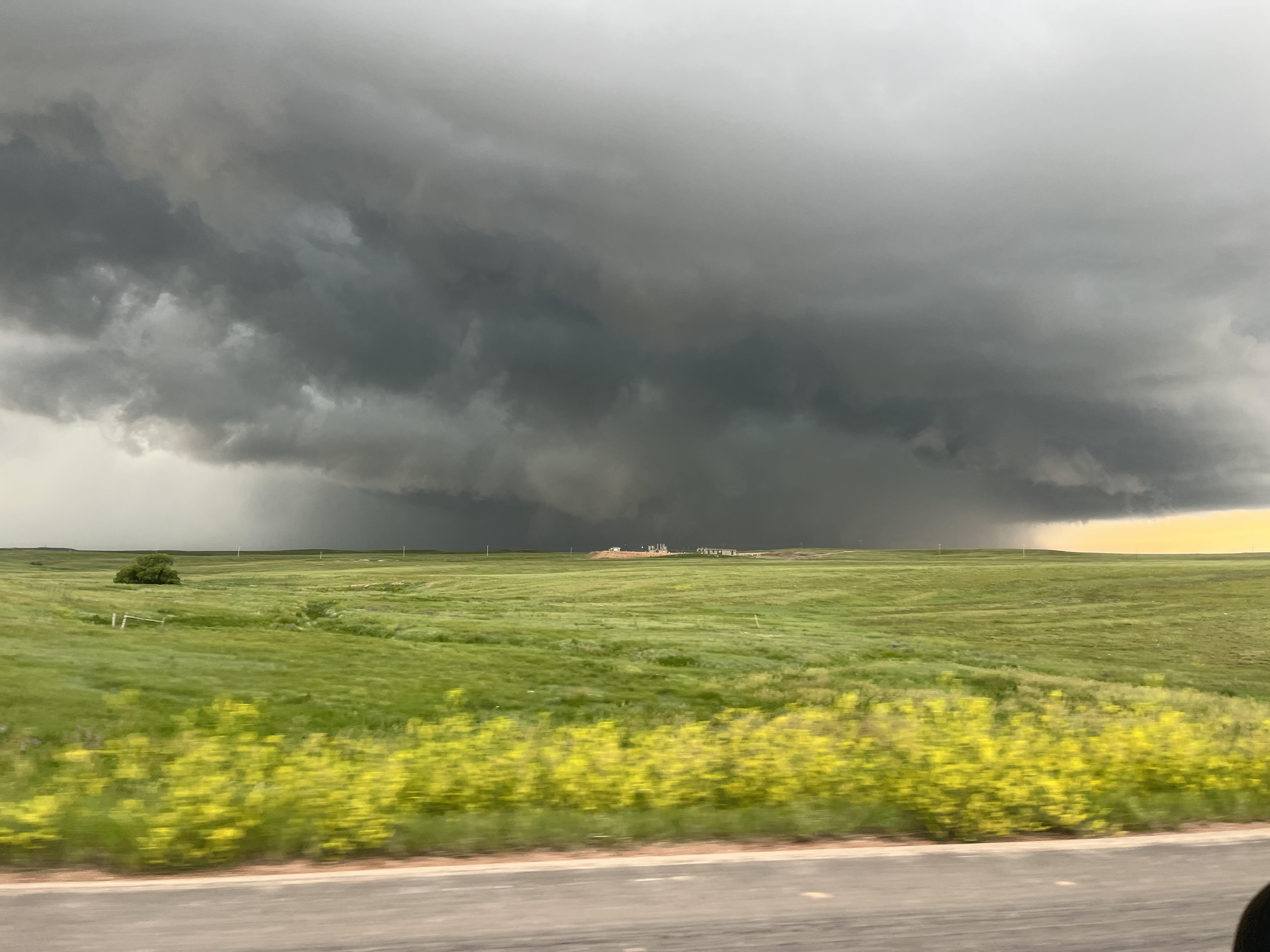
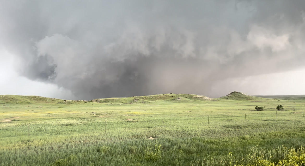
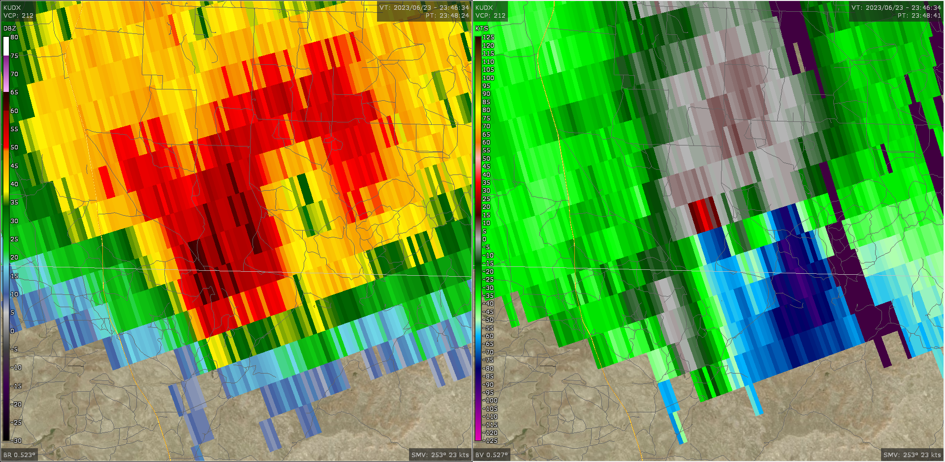
A major severe weather and flooding event occurred on June 23, 2023 over parts of northeastern Wyoming and western South Dakota. A long-track tornado moved across southern Campbell and Weston Counties, striking the North Antelope Rochelle Coal Mine. Elsewhere, significant flash flooding occurred from Spearfish to Saint Onge, and more widespread flooding occurred across parts of the western South Dakota plains. A few discrete storms produced hail up to 2" in diameter across western South Dakota and northeastern Wyoming. Several strong/damaging wind reports occurred later as the severe thunderstorms moved from western into central South Dakota. As can be seen in the lightning map to the right (click to enlarge), thunderstorms occurred across essentially all of our forecast area from northeastern Wyoming into south-central South Dakota. Positive cloud-to-ground flashes were especially notable with the tornadic storm that affected the North Antelope Rochelle Coal Mine as well as the Spearfish supercell that produced flash flooding and large hail. |
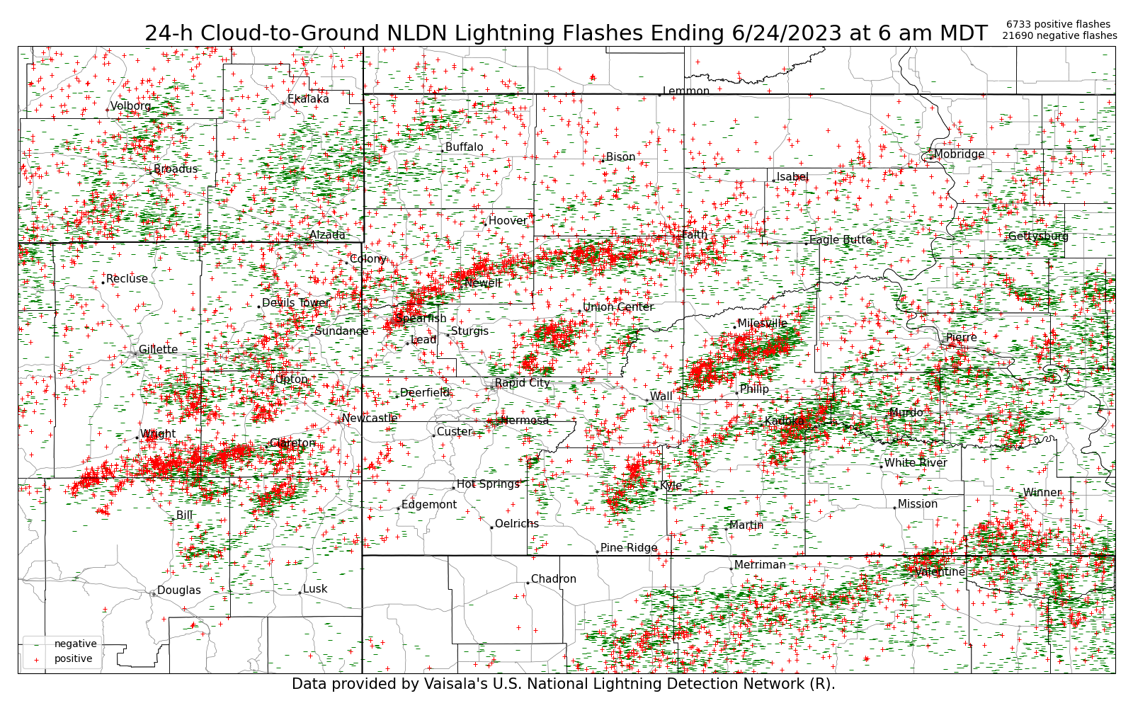 Here is the 24-hour cloud-to-ground lightning map from 6 am MDT Friday (6/23) to 6 am MDT Saturday (6/24). Red plus signs indicate positive polarity flashes and green dashes indicate negative polarity flashes. Total flash counts in upper right. |
Tornadoes
|
Tornado - North Antelope Rochelle Mine
Track Map 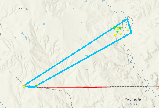 
Downloadable KMZ File |
||||||||||||||||
|
||||||||||||||||
The Enhanced Fujita (EF) Scale classifies tornadoes into the following categories:
| EF0 Weak 65-85 mph |
EF1 Moderate 86-110 mph |
EF2 Significant 111-135 mph |
EF3 Severe 136-165 mph |
EF4 Extreme 166-200 mph |
EF5 Catastrophic 200+ mph |
 |
|||||
Rainfall & Flooding
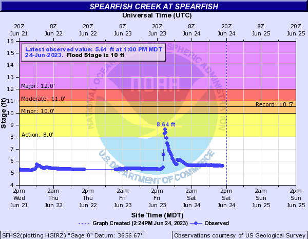
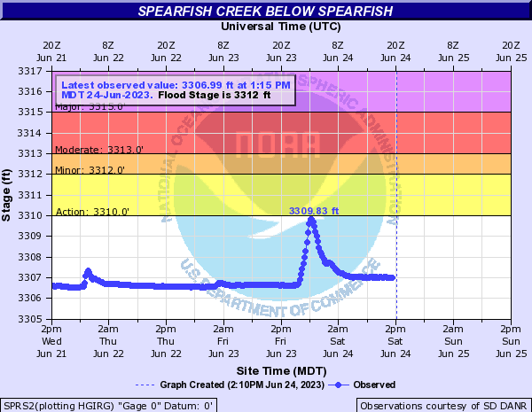
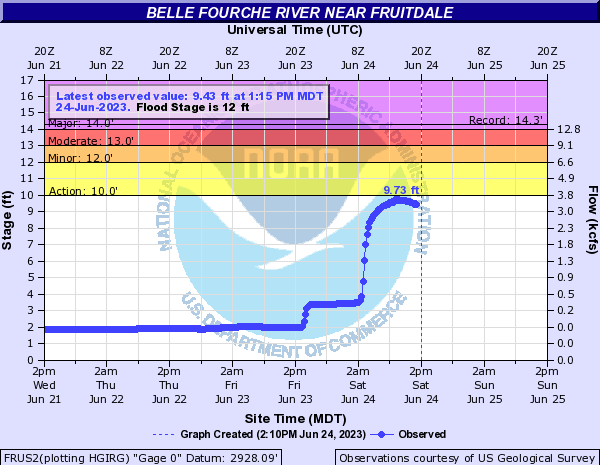
Some areas received very heavy rainfall of over 3 inches, and this caused flash flooding, most notably in the Spearfish area.
Hydrographs
 |
 |
 |
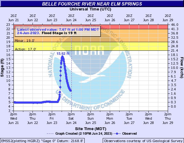 |
| Hydrograph along Spearfish Creek at Spearfish, showing a rapid increase in levels during and after heavy rainfall, followed by receding water. | Hydrograph along Spearfish Creek below Spearfish, showing a rapid increase in levels during and after heavy rainfall, followed by receding water. | Hydrograph along the Belle Fourche River near Fruitdale, showing a large increase in river levels during and after heavy rainfall. | Hydrograph along the Belle Fourche River near Elm Springs, showing a large increase in river levels during and after heavy rainfall, followed by receding water. |
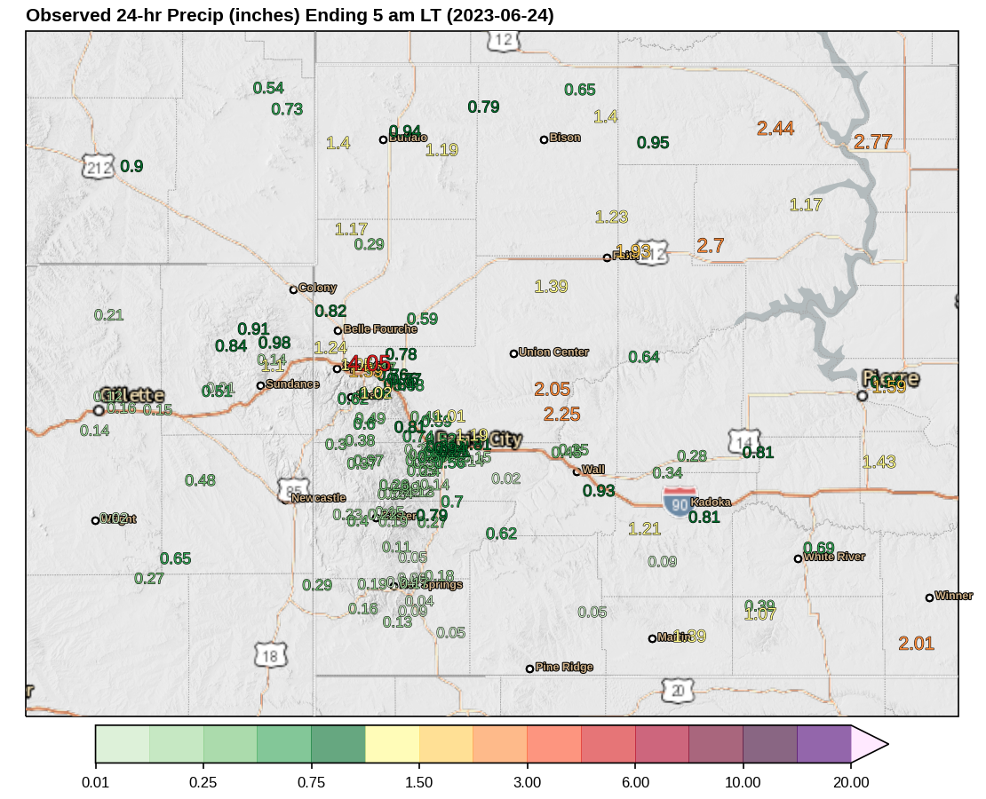
Rainfall Observations and Radar-Estimated Precipitation
 |
 |
| Observed 24-hour rainfall reports (inches) from 6 am MDT Friday (6/23) to 6 am MDT Saturday (6/24). | Radar-estimated 24-hour precipitation (inches) from 6 am MDT Friday (6/23) to 6 am MDT Saturday (6/24). |
24-Hour Rainfall Reports (by County) Ending Saturday Morning, June 24, 2023
**********************24 HOUR RAINFALL**********************

LOCATION              24 HOUR      TIME/DATE  COMMENTS
                     RAINFALL       MEASURED
                     (inches)

SOUTH DAKOTA

...Bennett County...
  8 NW Vetal             1.23   600 AM  6/24  CoCoRaHS
  8 E Martin             1.15   700 AM  6/24  Co-Op Observer
  Martin                 0.78   720 AM  6/24  Facebook
  5 NW Swett             0.42   800 AM  6/23  CoCoRaHS
  2 W Swett              0.42   600 AM  6/24  CoCoRaHS

...Butte County...
  1 NNW Nisland          2.01   800 AM  6/24  SDSU Mesonet
  27 WNW Castle Rock     1.17   800 AM  6/24  RAWS
  3 SE Nisland           0.75   800 AM  6/24  CoCoRaHS
  Newell                 0.20   900 AM  6/23  Co-Op Observer

...Campbell County...
  25 ESE Wright          0.42   800 AM  6/23  RAWS
  5 NNW Dwtn Gillette    0.12   800 AM  6/24  ASOS

...Custer County...
  3 SSW Argyle           1.50   700 AM  6/23  CoCoRaHS
  7 WSW Folsom           1.26   600 AM  6/24  CoCoRaHS
  7 WSW Fairburn         1.15   600 AM  6/23  CoCoRaHS
  2 SSW Custer           0.64   800 AM  6/23  ASOS
  Hermosa                0.63   600 AM  6/23  CoCoRaHS
  Jewel Cave             0.61   800 AM  6/23  SDSU Mesonet
  2 WNW Custer           0.61   800 AM  6/23  RAWS
  4 W Custer             0.58   800 AM  6/23  CWOP
  5 ENE Custer           0.57   700 AM  6/23  CoCoRaHS
  1 WNW Wind Cave Visi   0.55   200 PM  6/23  Co-Op Observer
  1 WSW Custer           0.53   800 AM  6/23  CoCoRaHS
  1 W Wind Cave Visito   0.51   800 AM  6/23  RAWS
  8 WNW Fairburn         0.49   800 AM  6/23  RAWS

...Fall River County...
  14 NNW Edgemont        5.87   800 AM  6/23  SDSU Mesonet
  9 NNE Edgemont         1.54   800 AM  6/23  RAWS
  2 W Hot Springs        1.47   700 AM  6/23  CoCoRaHS
  14 NW Edgemont         0.95   800 AM  6/23  CoCoRaHS
  2 ENE Edgemont         0.94   700 AM  6/23  CoCoRaHS
  Hot Springs            0.83   700 AM  6/23  CoCoRaHS
  4 W Hot Springs        0.71   700 AM  6/23  CoCoRaHS
  Edgemont               0.68   700 AM  6/23  CoCoRaHS
  1 S Hot Springs        0.64   800 AM  6/23  CoCoRaHS
  1 NNE Edgemont         0.63   700 AM  6/23  Co-Op Observer
  2 SSW Oral             0.38   800 AM  6/23  SDSU Mesonet
  Oral                   0.37   700 AM  6/23  Co-Op Observer
  14 SSW Provo           0.37   600 AM  6/23  CoCoRaHS
  7 W Ardmore            0.20   800 AM  6/23  SDSU Mesonet

...Haakon County...
  12 SSE Milesville      3.88   600 AM  6/24  CoCoRaHS
  12 WNW Philip          1.45   800 AM  6/24  CoCoRaHS
  17 SW Milesville       1.33   800 AM  6/24  CoCoRaHS
  3 E Midland            1.25   700 AM  6/24  CoCoRaHS
  9 N Kirley             1.14   700 AM  6/24  CoCoRaHS
  7 N Kirley             1.08   700 AM  6/24  CoCoRaHS
  5 NE Milesville        1.00   700 PM  6/23  Co-Op Observer
  11 W Milesville        0.71   800 AM  6/24  SDSU Mesonet
  3 SE Philip            0.43   631 AM  6/24  CoCoRaHS
  2 E Cottonwood         0.36   200 PM  6/23  Co-Op Observer
  3 E Philip             0.28   800 AM  6/24  ASOS

...Harding County...
  9 S Ludlow             1.51   700 AM  6/24  CoCoRaHS
  10 W Reva              1.17   800 AM  6/24  SDSU Mesonet
  1 N Buffalo            0.94   800 AM  6/24  ASOS
  9 NW Ludlow            0.90   430 AM  6/24  CoCoRaHS
  9 SSW Ladner           0.87   700 AM  6/23  CoCoRaHS
  5 SSE Ralph            0.80   800 AM  6/24  CWOP
  9 WSW Ladner           0.65   800 AM  6/24  CoCoRaHS

...Jackson County...
  3 WNW Kadoka           1.58   530 AM  6/24  CoCoRaHS
  2 E Cottonwood         0.45   800 AM  6/24  SDSU Mesonet
  3 WSW Wanblee          0.20   700 AM  6/23  CoCoRaHS

...Lawrence County...
  2 NNW Saint Onge       5.10   800 AM  6/24  Trained Spotter
  1 SSE Dwtn Spearfish   3.90   800 AM  6/24  CoCoRaHS
  1 NW Dwtn Spearfish    1.71   500 AM  6/24  CoCoRaHS
  3 SE Spearfish         1.59   800 AM  6/24  RAWS
  2 WNW Dwtn Spearfish   1.32   700 AM  6/24  CoCoRaHS
  1 E Lead               1.02   800 AM  6/24  CWOP
  5 SSE Dwtn Spearfish   0.95   710 AM  6/24  CoCoRaHS
  2 NW Central City      0.87   546 AM  6/24  CoCoRaHS
  5 SW Brownsville       0.85   800 AM  6/23  CWOP
  Nemo                   0.81   800 AM  6/24  RAWS
  3 SE Saint Onge        0.79   615 AM  6/24  CoCoRaHS
  6 NNW Dwtn Spearfish   0.76   700 AM  6/24  CoCoRaHS
  Lead                   0.51   900 AM  6/23  Co-Op Observer
  1 NNW Dwtn Spearfish   0.32  1000 AM  6/23  Co-Op Observer

...Meade County...
  6 WSW Opal             2.08   800 AM  6/23  CWOP
  1 NNE Faith            2.05   800 AM  6/24  ASOS
  4 NNW Elm Springs      2.00   600 AM  6/24  CoCoRaHS
  5 NNE Stoneville       1.99   850 AM  6/23  CoCoRaHS
  8 SE Mud Butte         1.97   700 AM  6/24  CoCoRaHS
  7 NNE Ellsworth AFB    1.60   700 AM  6/24  CoCoRaHS
  2 SW Howes             1.42   700 AM  6/24  CoCoRaHS
  6 WNW Union Center     1.30   700 AM  6/23  CoCoRaHS
  6 NE Summerset         1.04   700 AM  6/24  CoCoRaHS
  6 SSW Fairpoint        1.01   700 AM  6/24  CoCoRaHS
  Union Center           0.94   800 AM  6/24  SDSU Mesonet
  1 NNW Piedmont         0.90   800 AM  6/23  NWS Employee
  Tilford                0.77   700 AM  6/23  CoCoRaHS
  4 NNW Sturgis          0.72   700 AM  6/24  CoCoRaHS
  2 N Summerset          0.70   800 AM  6/23  CWOP
  9 NNE Sturgis          0.56   700 AM  6/24  CoCoRaHS
  4 NNW Tilford          0.55   800 AM  6/24  CoCoRaHS
  4 NNE Summerset        0.55   530 AM  6/24  CoCoRaHS
  7 E Sturgis            0.42   800 AM  6/24  SDSU Mesonet
  2 E Sturgis            0.34   700 PM  6/23  Co-Op Observer
  8 WSW Hereford         0.21   700 AM  6/23  CoCoRaHS

...Mellette County...
  4 NE Wood              1.81   700 AM  6/24  CoCoRaHS
  7 N Wood               1.41   600 AM  6/24  CoCoRaHS
  12 NNW White River     1.35   700 AM  6/24  CoCoRaHS
  3 NE Norris            1.30   600 AM  6/24  CoCoRaHS
  9 N Cedar Butte        0.97   600 AM  6/24  CoCoRaHS
  2 SSW Norris           0.92   700 AM  6/24  CoCoRaHS
  5 ESE Norris           0.75   614 AM  6/24  Trained Spotter
  1 S White River        0.63   800 AM  6/24  SDSU Mesonet
  4 WNW Cedar Butte      0.57   800 AM  6/24  SDSU Mesonet

...Oglala Lakota County...
  3 ESE Pine Ridge       0.75   800 AM  6/23  ASOS
  3 ENE Kyle             0.61   700 AM  6/23  Co-Op Observer
  5 NE Porcupine         0.55   800 AM  6/23  RAWS

...Pennington County...
  2 WNW Dwtn Rapid Cit   1.55   700 AM  6/24  CoCoRaHS
  1 ESE Pactola Resv     1.28   900 AM  6/23  Co-Op Observer
  3 W Scenic             1.19   700 AM  6/24  CoCoRaHS
  1 N Johnson Siding     1.16   800 AM  6/23  CoCoRaHS
  6 W Rochford           1.09   800 AM  6/23  RAWS
  1 SW Dwtn Rapid City   1.07   700 AM  6/24  CoCoRaHS
  1 N Hisega             0.99   700 AM  6/23  CoCoRaHS
  3 NNE Johnson Siding   0.98   700 AM  6/23  CoCoRaHS
  1 NNW Hisega           0.95   600 AM  6/23  CoCoRaHS
  8 S Wall               0.92   800 AM  6/24  RAWS
  1 NE Dwtn Rapid City   0.86   600 AM  6/24  CoCoRaHS
  3 E Wasta              0.84   700 AM  6/23  CoCoRaHS
  4 NNE Johnson Siding   0.84   800 AM  6/23  CoCoRaHS
  Wasta                  0.81   800 AM  6/23  CWOP
  1 SSE Box Elder        0.81   800 AM  6/24  CWOP
  4 W Rapid City         0.81   800 AM  6/23  RAWS
  19 NNE Creighton       0.77   700 AM  6/24  CoCoRaHS
  4 W Dwtn Rapid City    0.76   700 AM  6/23  CoCoRaHS
  4 WNW Dwtn Rapid Cit   0.73   700 AM  6/24  CoCoRaHS
  4 ESE Dwtn Rapid Cit   0.73   800 AM  6/23  CoCoRaHS
  Hill City              0.72   700 AM  6/23  Co-Op Observer
  4 WNW Rapid City Arp   0.72   700 AM  6/23  CoCoRaHS
  4 S Dwtn Rapid City    0.68   700 AM  6/24  CoCoRaHS
  2 SSE Dwtn Rapid Cit   0.68   700 AM  6/24  CoCoRaHS
  2 SW Dwtn Rapid City   0.67   800 AM  6/24  NWS Employee
  12 S Quinn             0.65   800 AM  6/23  CoCoRaHS
  2 ENE Wall             0.63   730 AM  6/23  CoCoRaHS
  2 ENE Sheridan Lake    0.61   800 AM  6/23  RAWS
  4 NW Dwtn Rapid City   0.60   700 AM  6/23  Co-Op Observer
  6 W New Underwood      0.54   700 AM  6/24  CoCoRaHS
  Rapid City Arpt        0.42   800 AM  6/23  ASOS
  1 WNW Caputa           0.42   800 AM  6/23  SDSU Mesonet
  Mount Rushmore         0.41  1258 AM  6/24  Co-Op Observer

...Perkins County...
  8 ESE Prairie City     1.25   700 AM  6/24  CoCoRaHS
  7 S Shadehill          1.24   800 AM  6/24  RAWS
  Bison                  1.16   800 AM  6/24  SDSU Mesonet
  9 SSE Sorum            1.09   700 AM  6/24  CoCoRaHS
  3 ESE Lemmon           0.96   800 AM  6/24  SDSU Mesonet
  14 WNW Lodgepole       0.61   800 AM  6/23  SDSU Mesonet

...Todd County...
  4 NW Parmelee          1.17   700 AM  6/24  CoCoRaHS
  14 S Mission           0.58   700 AM  6/24  Co-Op Observer
  Parmlee                0.45   800 AM  6/24  RAWS
  16 SSE Mission         0.43   600 AM  6/24  CoCoRaHS
  7 ESE Rosebud          0.36   800 AM  6/24  SDSU Mesonet
  7 SE Saint Francis     0.01   900 AM  6/23  CoCoRaHS

...Tripp County...
  6 NNW Wewela           2.50   600 AM  6/24  CoCoRaHS
  9 N Wewela             2.35   600 AM  6/24  CoCoRaHS
  9 ENE Wewela           1.31   600 AM  6/24  CoCoRaHS
  5 WSW Colome           1.26   730 AM  6/24  CoCoRaHS
  2 WSW Hamill           0.96   700 AM  6/24  CoCoRaHS
  2 SSE Ideal            0.85   600 AM  6/24  CoCoRaHS
  11 SSE Hamill          0.69   600 AM  6/24  CoCoRaHS
  6 N Hamill             0.67   600 AM  6/24  CoCoRaHS
  2 W Hamill             0.62   800 AM  6/24  SDSU Mesonet
  1 NE Winner            0.57   800 AM  6/24  ASOS

...Ziebach County...
  5 NNW Dupree           3.75   700 AM  6/23  CoCoRaHS
  9 WSW Red Elm          2.00   631 AM  6/24  Trained Spotter
  1 WSW South Eagle Bu   1.80   800 AM  6/24  SDSU Mesonet

WYOMING

...Campbell County...
  14 SW Weston           0.30   800 AM  6/24  CoCoRaHS
  11 NNE Weston          0.28   700 AM  6/24  CoCoRaHS
  3 NNE Rozet            0.26   600 AM  6/24  CoCoRaHS
  14 NNW Dwtn Gillette   0.25   700 AM  6/24  CoCoRaHS
  1 NE Echeta            0.23   800 AM  6/24  RAWS
  3 S Dwtn Gillette      0.23   600 AM  6/24  CoCoRaHS
  Wright                 0.19   700 AM  6/23  CoCoRaHS
  3 E Dwtn Gillette      0.17   800 AM  6/24  CWOP
  1 SSW Rozet            0.17   800 AM  6/24  CWOP
  10 SW Dwtn Gillette    0.16   800 AM  6/24  CWOP
  5 SW Dwtn Gillette     0.02   700 AM  6/23  CoCoRaHS
  4 SE Gillette          0.01   530 PM  6/23  Co-Op Observer
  5 SSE Dwtn Gillette    0.01   700 AM  6/23  CoCoRaHS

...Crook County...
  1 S Devils Tower       0.94   800 AM  6/24  RAWS
  Sundance               0.68   600 AM  6/24  CoCoRaHS
  7 SE Moorcroft         0.68   800 AM  6/24  CoCoRaHS
  8 ENE Alva             0.56   700 AM  6/24  CoCoRaHS
  4 SSE Devils Tower     0.55   730 AM  6/24  CoCoRaHS
  1 ESE Moorcroft        0.45   600 AM  6/24  CoCoRaHS
  3 NNE Moorcroft        0.41   600 AM  6/24  CoCoRaHS
  6 SW Beulah            0.20   800 AM  6/23  CoCoRaHS

...Weston County...
  1 WNW Clareton         1.85   700 AM  6/23  CoCoRaHS
  19 SW Upton            0.83   800 AM  6/23  CWOP
  10 N Osage             0.72   700 AM  6/24  CoCoRaHS
  8 NNW Newcastle        0.68   700 AM  6/23  CoCoRaHS
  4 SE Upton             0.63   700 AM  6/24  CoCoRaHS
  11 NE Morrisey         0.54   700 AM  6/23  CoCoRaHS
  1 N Upton              0.53   800 AM  6/24  CoCoRaHS
  1 WSW Newcastle        0.41   700 AM  6/23  CoCoRaHS
  3 E Newcastle          0.41   600 AM  6/24  CoCoRaHS
  5 SW Upton             0.37   700 AM  6/24  CoCoRaHS
Photos & Video
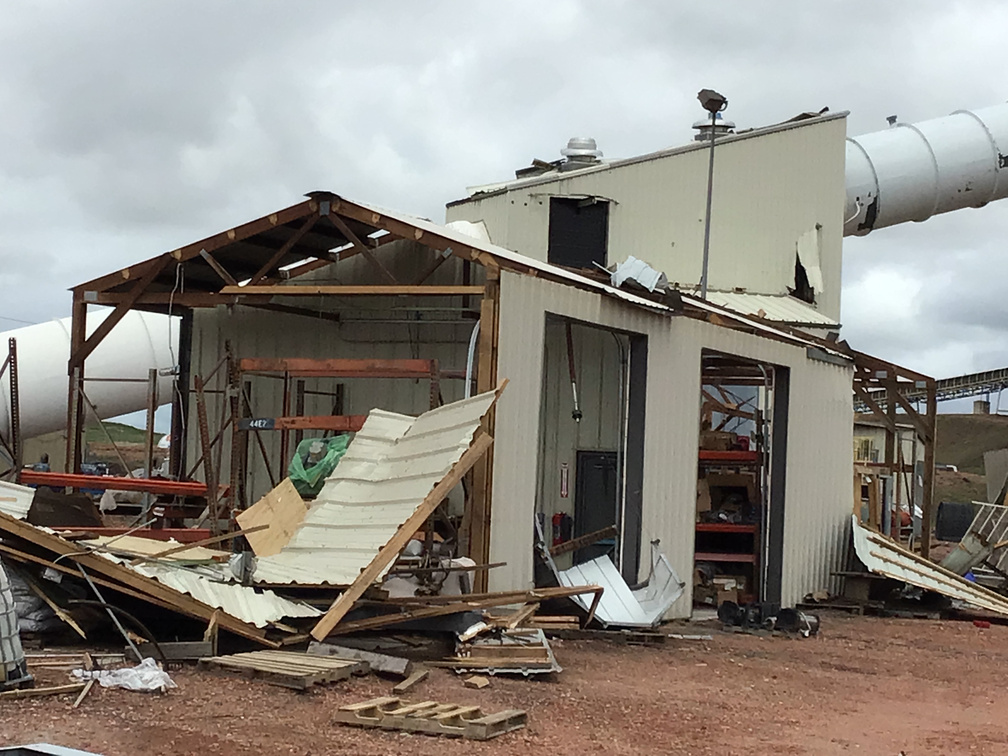
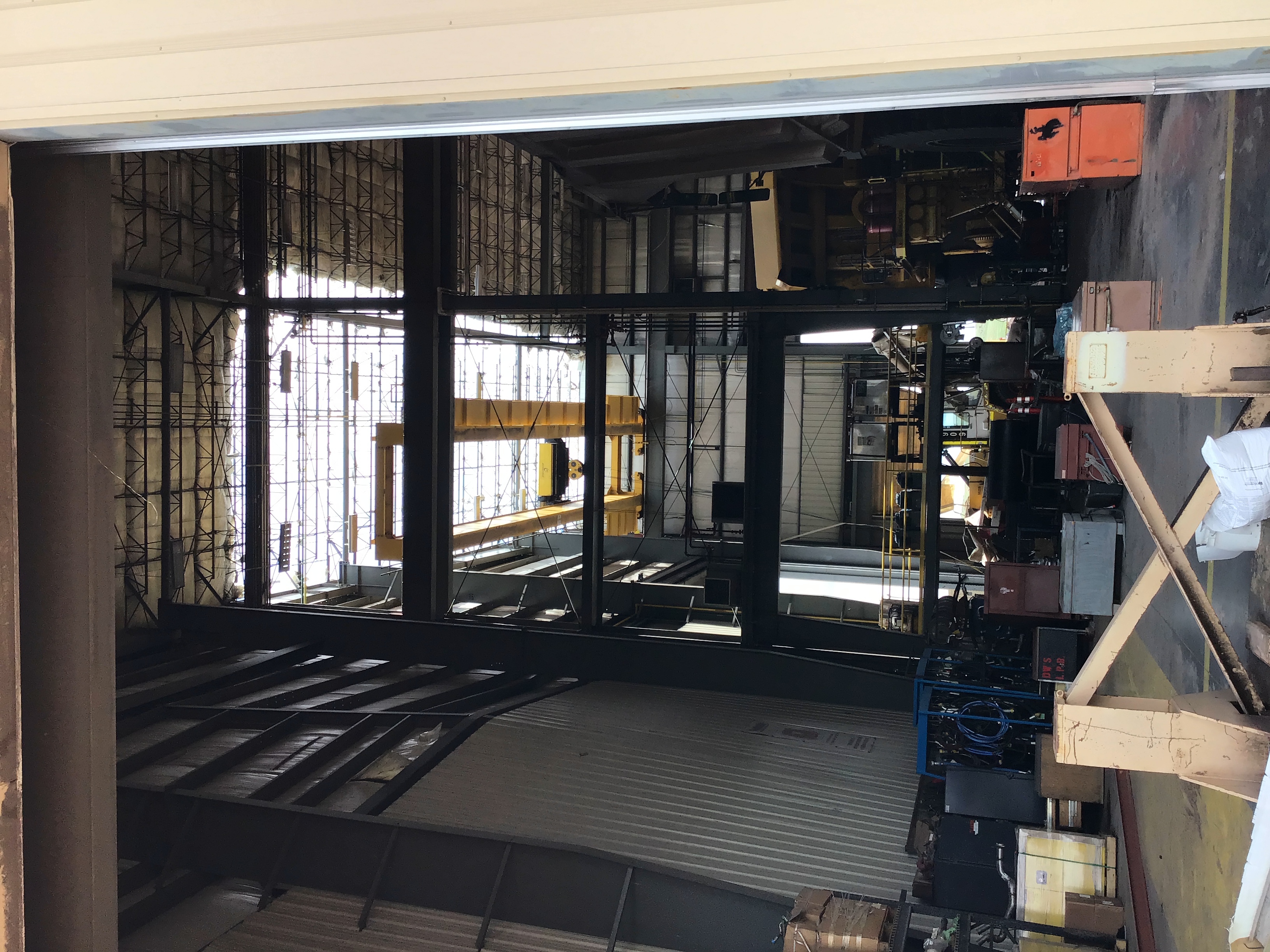
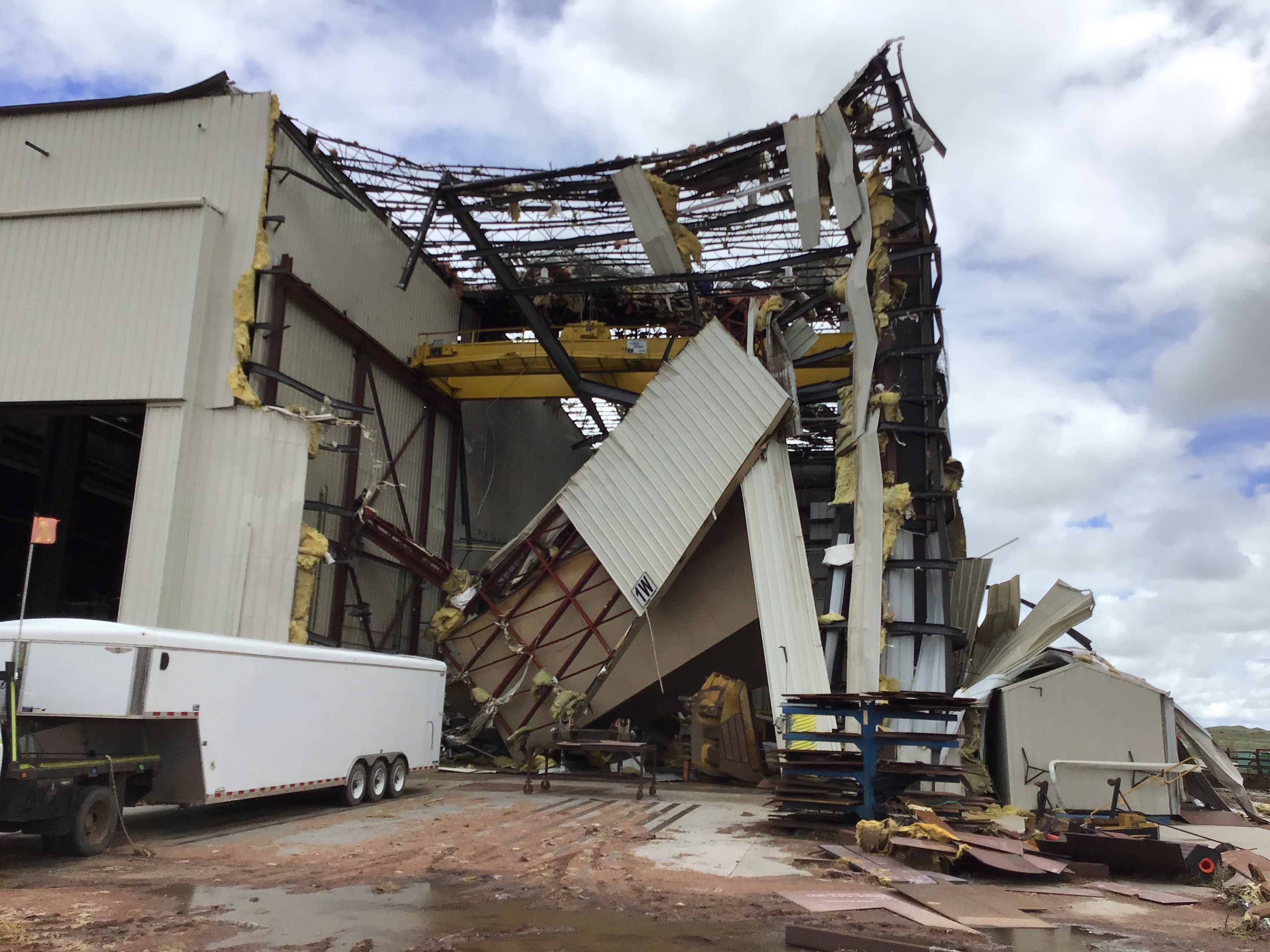
Tornado Damage
 |
 |
 |
 |
| Tornado damage at North Antelope Rochelle Mine credit: NWS |
|||
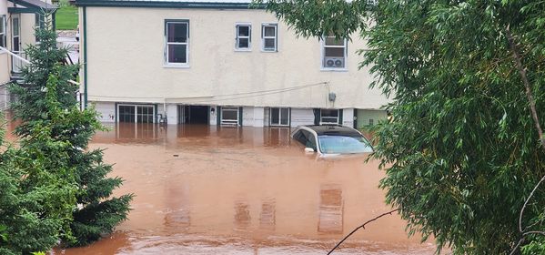
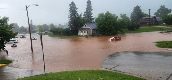
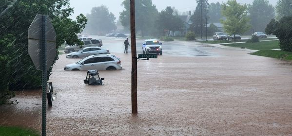
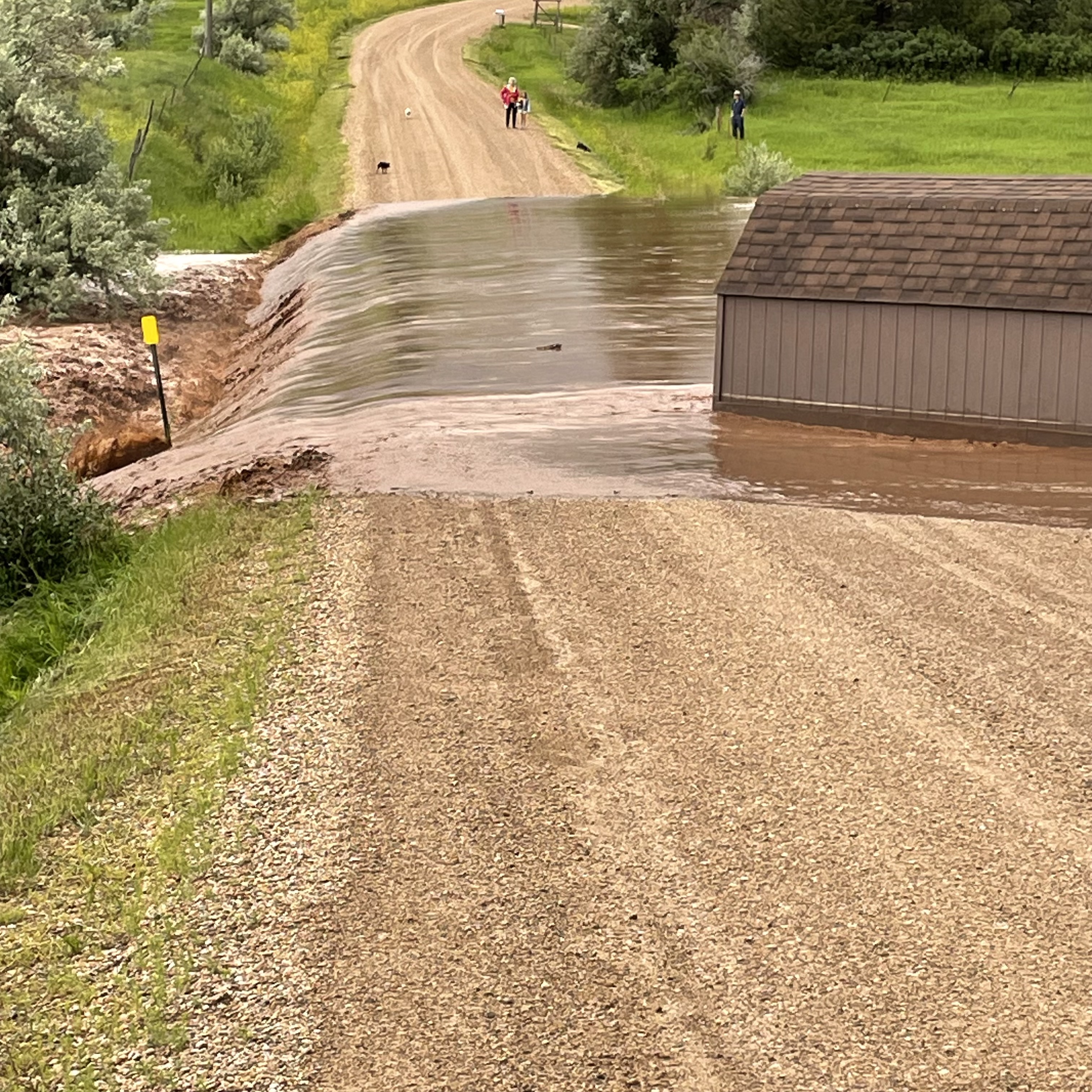
Flooding
 |
 |
 |
| Flooding at Federal St and 7th St in Spearfish (credit: Lucas Pummel) |
||
 |
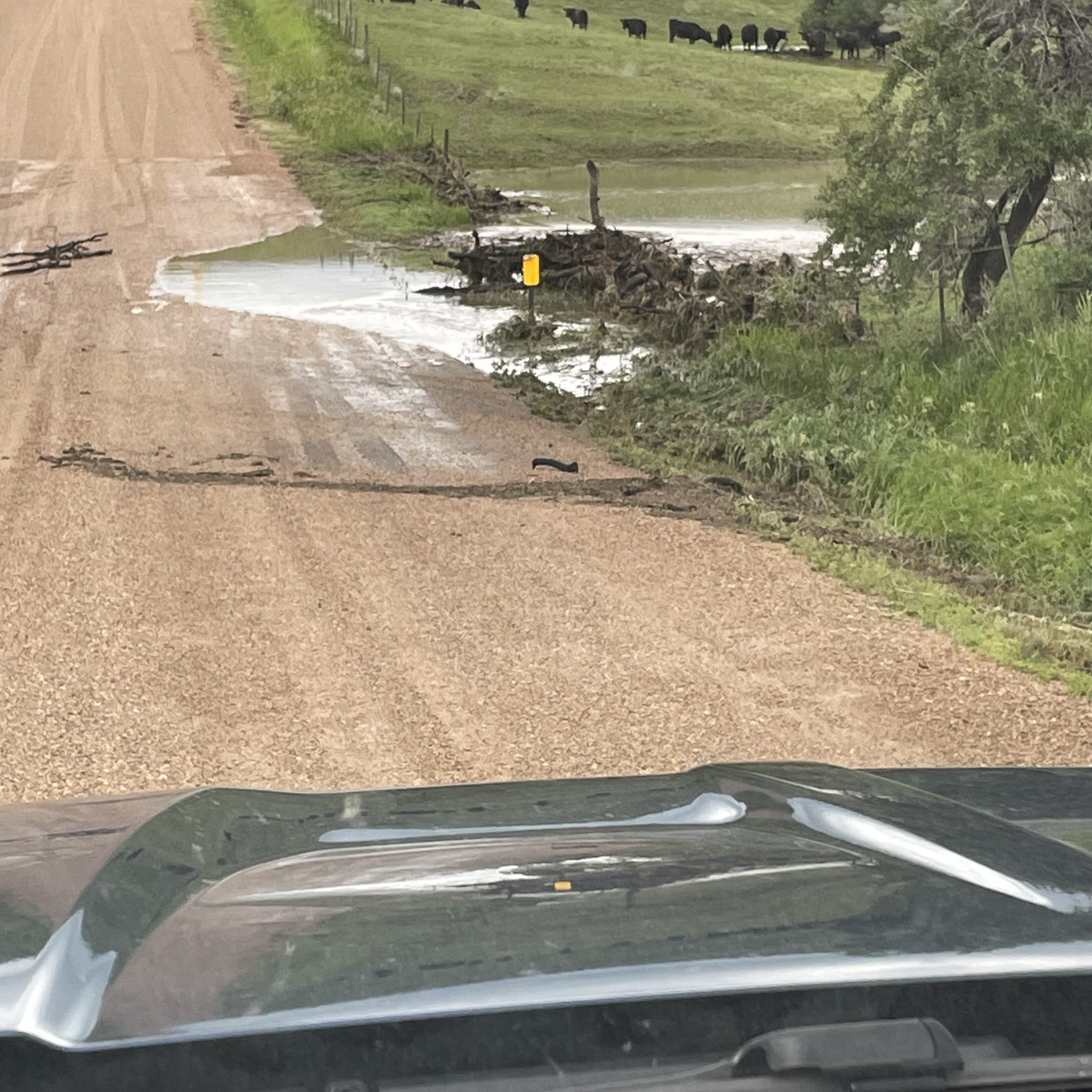 |
 |
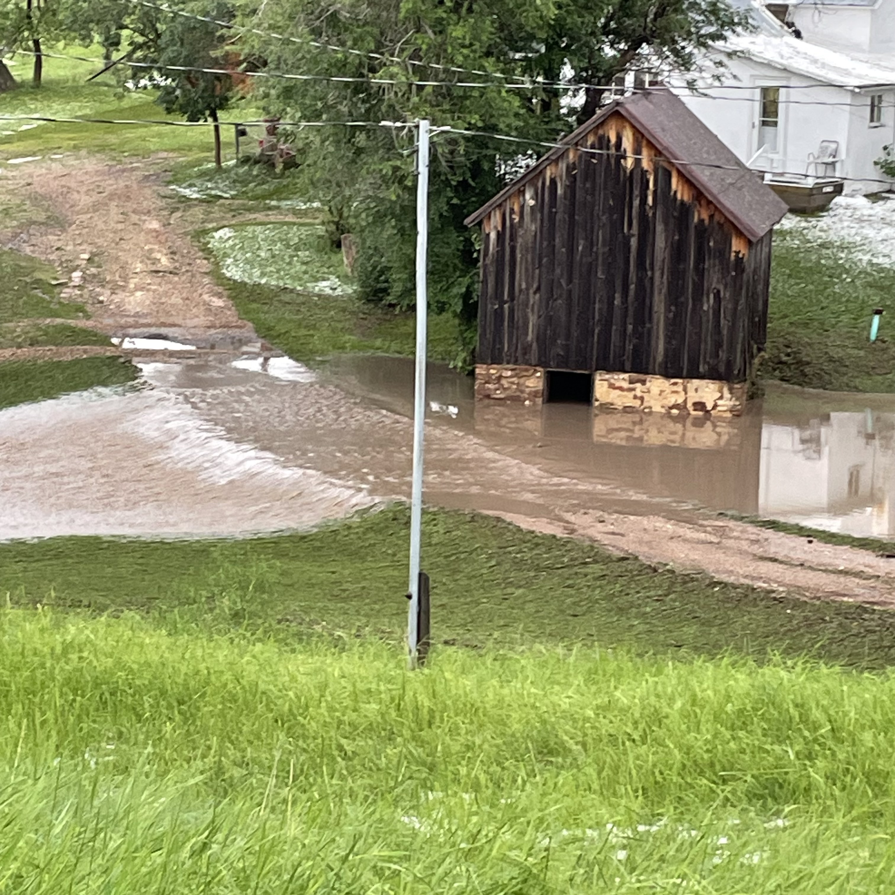 |
 |
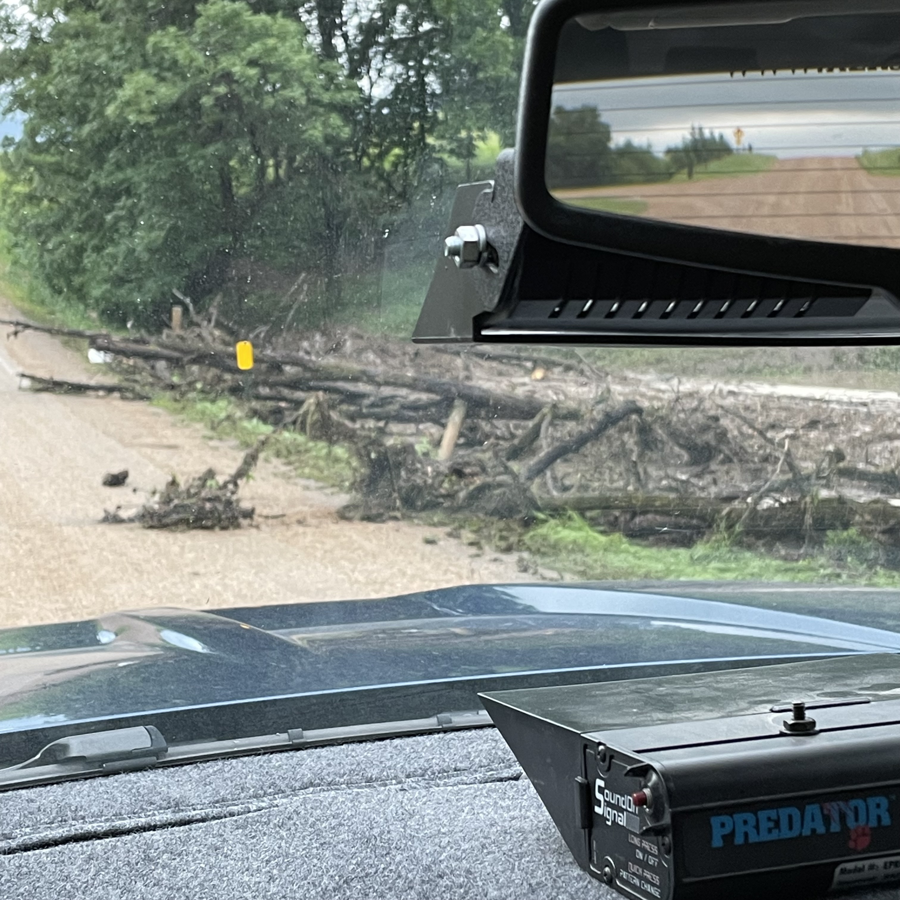 |
| Flooding in northern Lawrence County (credit: JD Geigle) |
||
Hail
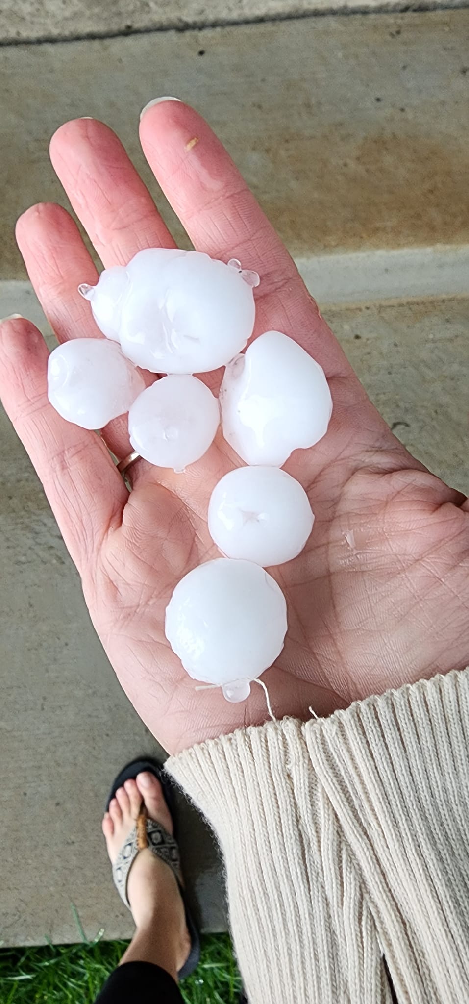 |
 |
 |
| Hail in Spearfish (credit: Kylie Braunesreither) |
Hail near Butte/Lawrence County line (credit: Matt Kerney) |
|
 |
 |
| Hail in Spearfish (credit: Ashley Marie) |
Hail near Butte/Lawrence County line (credit: Matt Kerney) |
Lightning
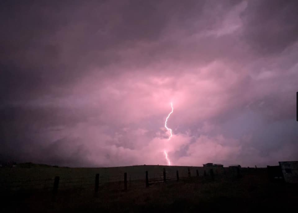 |
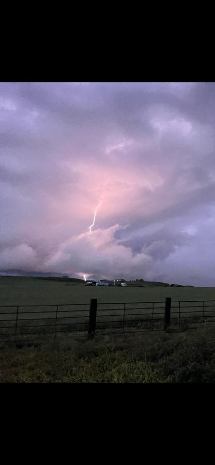 |
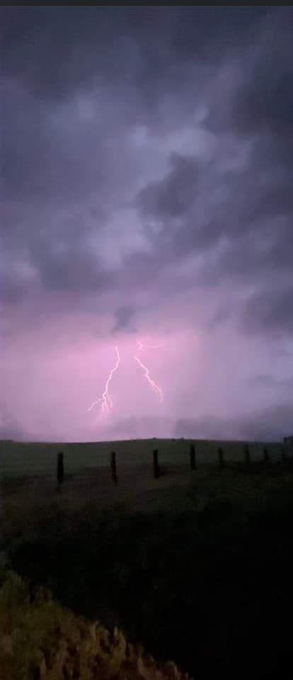 |
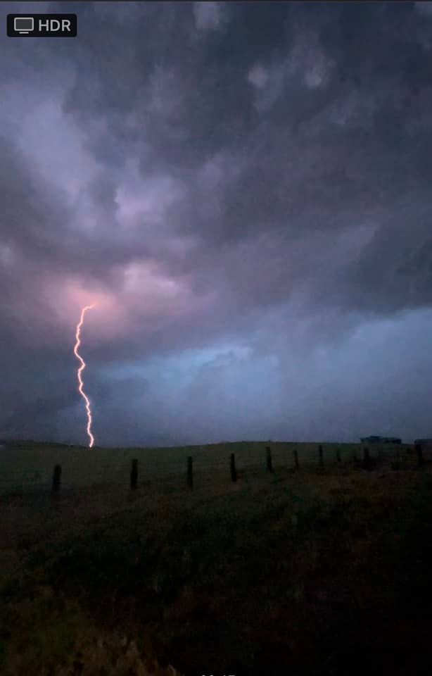 |
| Lightning north of New Underwood (credit: Jacie Schrempp) |
|||
Radar Products & Animation
 |
 |
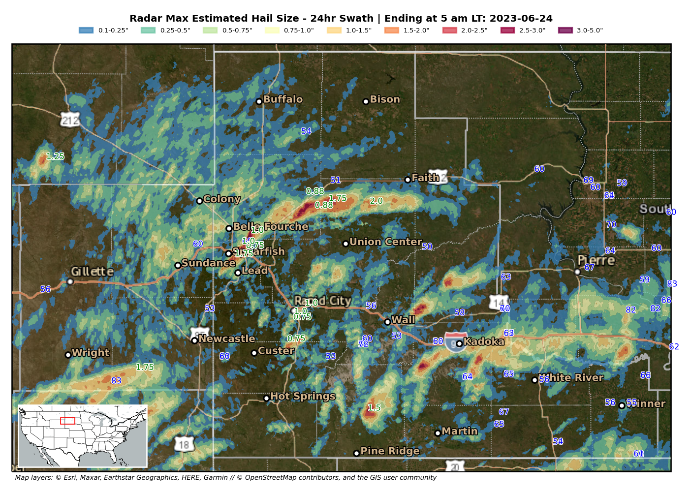
| Radar-based maximum estimated hail size from 6 am MDT June 23, 2023 to 6 am MDT June 24, 2023. Preliminary hail reports (inches) are shown in green and preliminary wind gust reports (mph) are shown in blue. | Radar-based midlevel storm rotation tracks from 6 am MDT June 23, 2023 to 6 am MDT June 24, 2023. Preliminary tornado reports are shown in red. |
Hourly radar animation from 11 am MDT on Friday, June 23, 2023 to 3 am MDT on Saturday, June 24, 2023.
Storm Reports
Here is a list of the wind and hail reports from the severe weather event on June 23–24, 2023. Below that is a map of the preliminary wind, hail, and tornado reports across our area from 6 am MDT on June 23, 2023 to 6 am MDT on June 24, 2023.
...MAXIMUM OBSERVED WINDS SORTED BY MAGNITUDE...

LOCATION                      MAX WIND    COMMENTS
                               MPH

25 ESE WRIGHT WY                 83        640 PM 6/23/2023
3 NNW SCENIC SD                  72        803 PM 6/23/2023
1 NE MIDLAND SD                  70       1108 PM 6/23/2023
6 W PARMELEE SD                  67       1145 PM 6/23/2023
2 W HAMILL SD                    66       1210 AM 6/24/2023
11 SW PARMELEE SD                65       1129 PM 6/23/2023
4 WNW CEDAR BUTTE SD             65       1125 PM 6/23/2023
7 E WANBLEE SD                   64       1055 PM 6/23/2023
9 ENE BELVIDERE SD               63        959 PM 6/23/2023
WEWELA SD                        61        111 AM 6/24/2023
8 W JEWEL CAVE SD                60        839 PM 6/23/2023
5 N SCENIC SD                    60        800 PM 6/23/2023
4 E CACTUS FLAT SD               60       1044 PM 6/23/2023
7 SW ALADDIN WY                  60        644 PM 6/23/2023
2 NW SAINT ONGE SD               60        450 PM 6/23/2023
1 ENE MUD BUTTE SD               58       1218 AM 6/24/2023
3 E PHILIP SD                    58       1037 PM 6/23/2023
4 SSE WITTEN SD                  56       1226 AM 6/24/2023
1 S WHITE RIVER SD               56       1140 PM 6/23/2023
16 WSW DWTN GILLETTE WY          56        422 PM 6/23/2023
3 NW WASTA SD                    56        940 PM 6/23/2023
1 NE WINNER SD                   55       1250 AM 6/24/2023
13 SSW REVA SD                   54       1158 PM 6/23/2023
15 SSE MISSION SD                54       1216 AM 6/24/2023
8 SSW FOLSOM SD                  53        954 PM 6/23/2023
FOUR CORNERS WY                  53        836 PM 6/23/2023
1 NNE FAITH SD                   53        116 AM 6/24/2023
8 S WALL SD                      53       1120 PM 6/23/2023
3 W UNION CENTER SD              51       1218 AM 6/24/2023
2 SW BRIDGER SD                  50       1005 PM 6/23/2023


...MAXIMUM HAIL SIZE SORTED BY MAGNITUDE...

LOCATION                      MAX SIZE    COMMENTS
                               IN/S/

2 SSW OPAL SD                  2.00        825 PM 6/23/2023
2 SE DWTN SPEARFISH SD         1.75        350 PM 6/23/2023
9 S MUD BUTTE SD               1.75        715 PM 6/23/2023
7 ENE ROCHELLE WY              1.75        735 PM 6/23/2023
5 SW SHARPS CORNER SD          1.50        700 PM 6/23/2023
2 NE KADOKA SD                 1.25        945 PM 6/23/2023
5 W HERMOSA SD                 1.00        734 PM 6/23/2023
7 ENE BELVIDERE SD             1.00        933 PM 6/23/2023
1 S DWTN RAPID CITY SD         1.00        741 PM 6/23/2023
2 W BOX ELDER SD               1.00        807 PM 6/23/2023
2 SE FRUITDALE SD              1.00        510 PM 6/23/2023
4 NNE SAINT ONGE SD            1.00        437 PM 6/23/2023
2 NW SAINT ONGE SD             1.00        450 PM 6/23/2023
21 ENE NEWELL SD               0.88        655 PM 6/23/2023
SAINT ONGE SD                  0.75        421 PM 6/23/2023
4 S DWTN RAPID CITY SD         0.75        722 PM 6/23/2023
5 WNW HERMOSA SD               0.75        740 PM 6/23/2023
12 S FAITH SD                  0.70        915 PM 6/23/2023
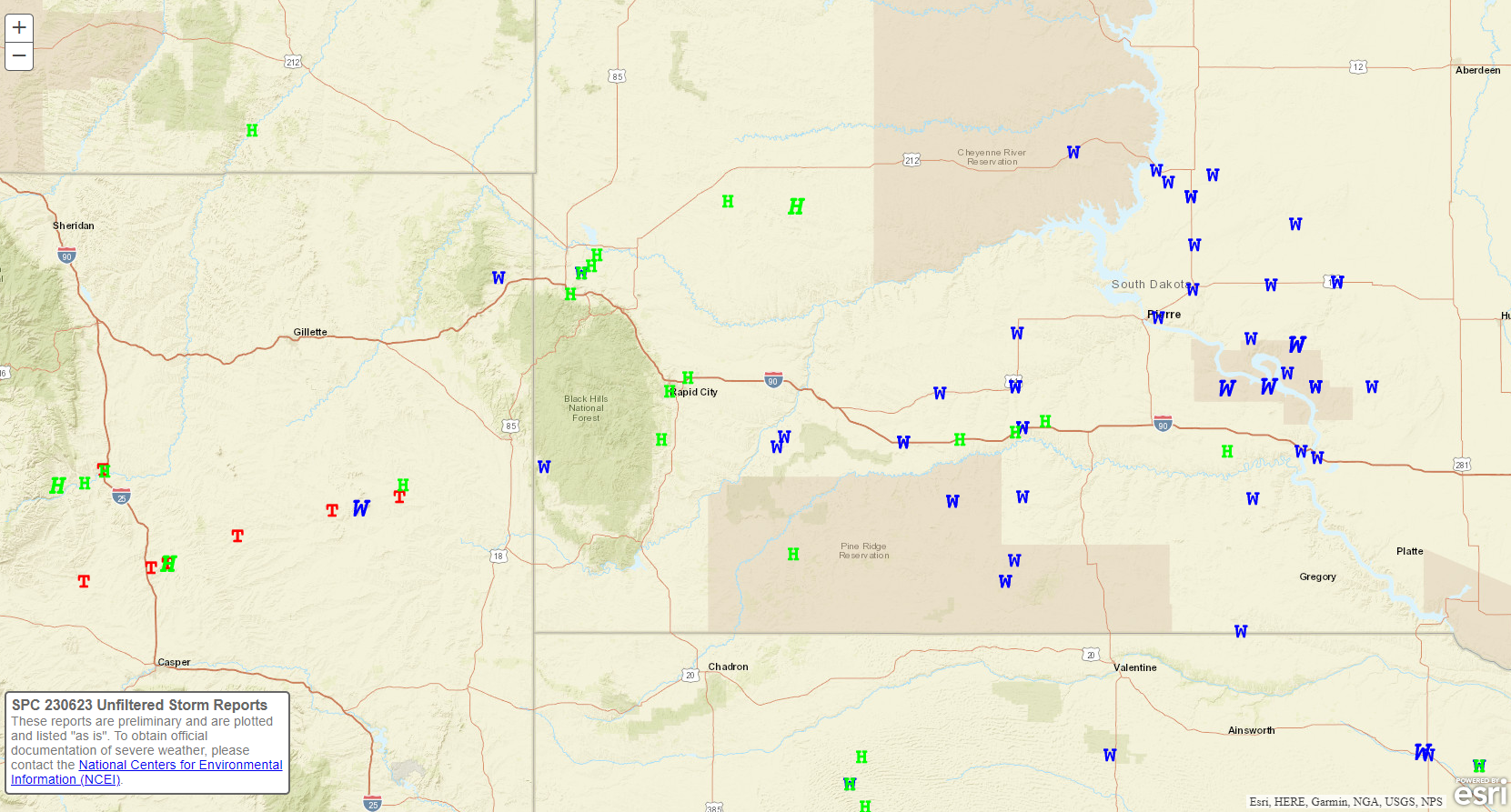 |
| Preliminary local storm reports from 6 am MDT June 23, 2023 to 6 am MDT June 24, 2023. Hail reports are shown with green Hs, wind reports are shown with a blue Ws, and tornado reports are shown with red Ts. State boundaries are in gray lines, and major interstates and highways are shown in orange/tan colors. |
 |
| Warnings issued by NWS Rapid City through the afternoon and evening of June 23, 2023. Red polygons indicate Tornado Warnings, yellow polygons indicate Severe Thunderstorm Warnings, and green polygons show Flash Flood Warnings. |
Environmental Analysis
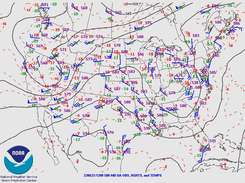
Upper-air analyses on the morning of June 23, 2023 captured a pronounced upper-level low over the Great Basin approaching the northern Rockies and High Plains (left image, click to enlarge). A surface analysis valid at the same time showed a stationary front stretching from far southeastern South Dakota southwestward through central Nebraska and extending westward through northern Colorado (right image, click to enlarge). This front had been pushed southward by overnight showers and thunderstorms, but it was expected to retreat northward as a warm front by the afternoon. North of the front, morning temperatures were in the 50s across much of northeastern Wyoming and western South Dakota, and skies were overcast.
 |
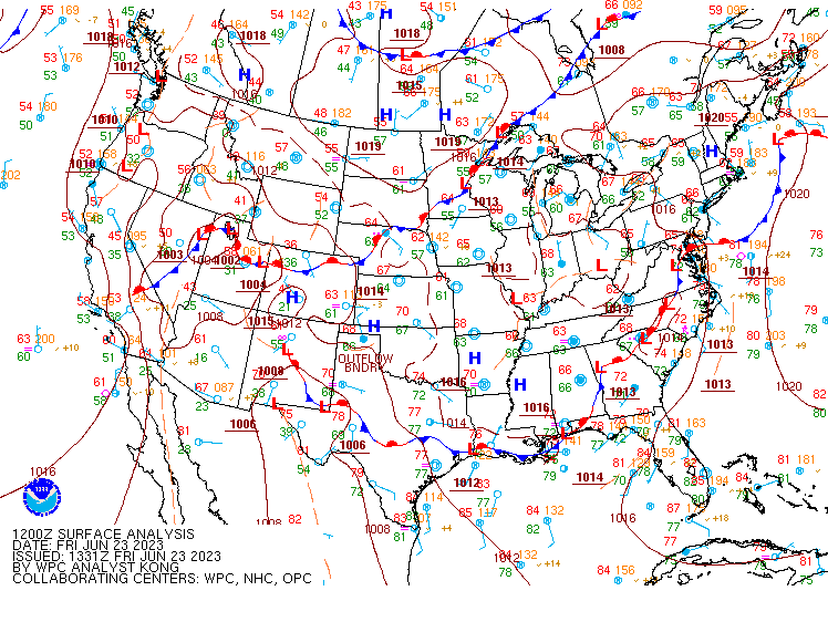 |
| 500-mb upper-air analysis valid at 6 am MDT on June 23, 2023. This level represents the midlevels of the troposphere, from around 17,000 to 19,000 feet above ground. | Surface analysis valid at 6 am MDT on June 23, 2023. |
The satellite animation below shows that clouds covered much of the area early Friday morning, with a few sub-severe thunderstorms moving across the area (bare ground is blue; water clouds are cyan to lavender; and high ice clouds are orange). Thunderstorms started to develop early in the afternoon around the Black Hills, with a much larger area of storms approaching from western/northwestern Wyoming. The thunderstorms congealed into a large complex of storms by late afternoon and moved across western South Dakota on Friday evening.
Hourly Day-Cloud-Phase GOES-16 satellite animation from 4:56 am until 11:56 pm MDT (6/23/2023). Animation courtesy of the College of DuPage NEXLAB Satellite and Radar website.
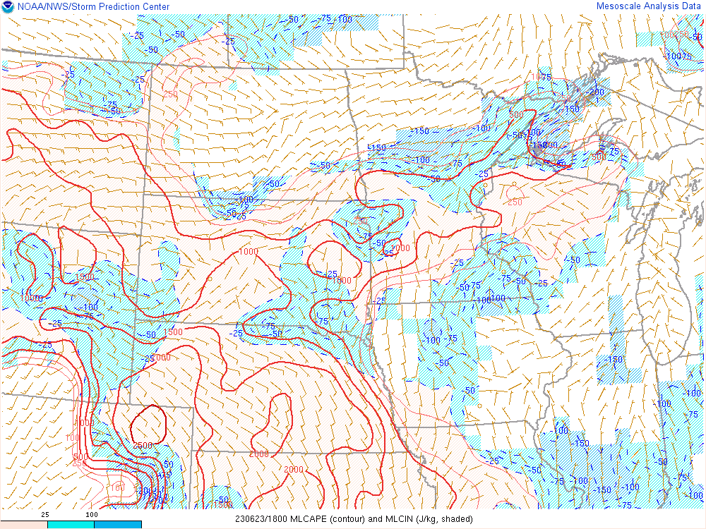
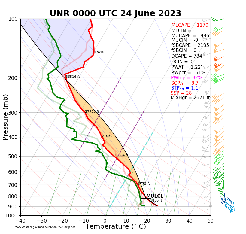
Through the morning, clouds decreased (see above satellite animation), with increasing sunshine allowing temperatures to climb into the 60s and 70s. With time, the front gradually lifted northward as a warm front. Near and south of the front, the atmosphere became unstable by the afternoon (refer to the first three images below). As the upper-level low approached the region, vertical wind shear also increased (per the second row of images below). This combination resulted in favorable conditions for a local severe weather outbreak, with a particularly supportive environment for tornadoes in place near the warm front from southern portions of northeastern Wyoming through central South Dakota (refer to the "significant tornado parameter" in the bottom right image). In addition, plenty of atmospheric water vapor was present to allow for heavy rainfall, with precipitable water values by 6 pm MDT exceeding 150% of normal (refer to the bottom left image).
 |
 |
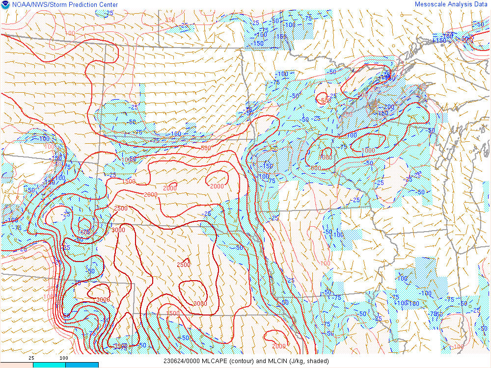 |
| Analyzed MLCAPE valid at noon MDT on June 23, 2023 | Analyzed MLCAPE valid at 3 pm MDT on June 23, 2023 | Analyzed MLCAPE valid at 6 pm MDT on June 23, 2023 |
 |
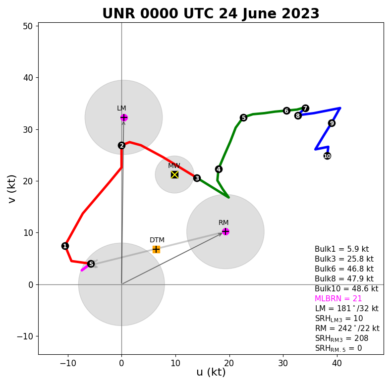 |
| Rapid City upper-air balloon sounding valid at 6 pm MDT on June 23, 2023. | Rapid City upper-air balloon hodograph valid at 6 pm MDT on June 23, 2023. |
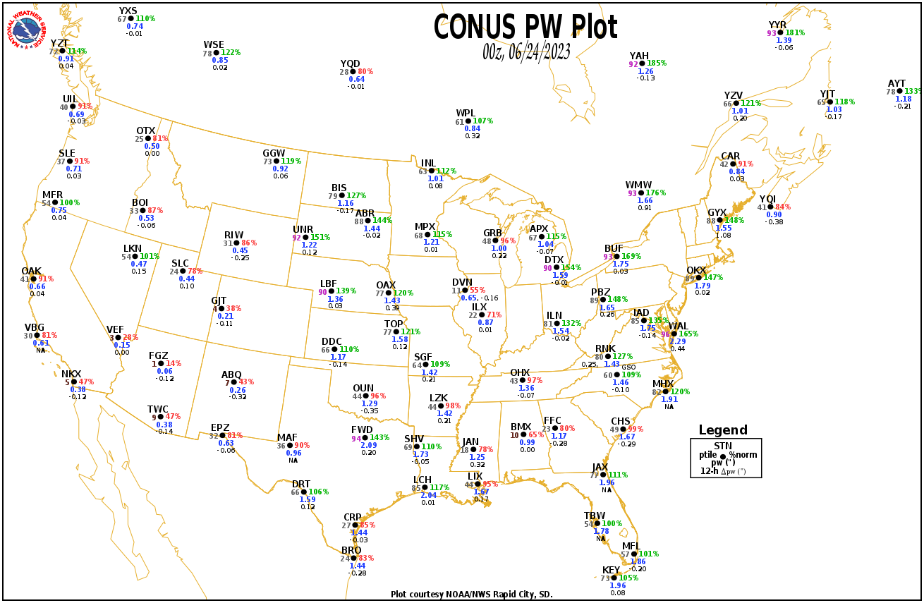 |
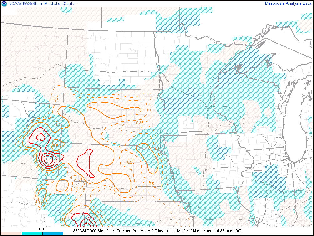 |
| Precipitable water plot valid at 6 pm MDT on June 23, 2023. | Significant tornado parameter valid at 6 pm MDT on June 23, 2023. |