Tropical Depression Two is expected to gradually strengthen and could bring tropical storm conditions to the Florida Panhandle beginning late Monday. Areas of flash flooding will be possible through Thursday along the eastern and central Gulf Coast. Severe thunderstorms will develop and move along a cold front crossing the Upper Midwest Monday, and through the Ohio Valley/Mid-Atlantic on Tuesday. Read More >
Overview
|
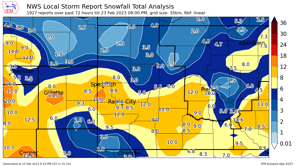
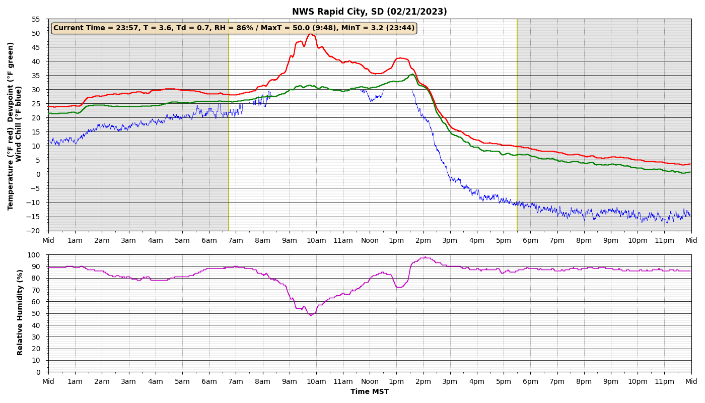
A snowstorm brought widespread snow and bitter cold weather on February 20-23, 2023, with most of the snow falling on February 21-22. Initially snow fell in northeastern Wyoming, the Black Hills, and parts of western South Dakota on Monday (20th) and early Tuesday (21st). Then, widespread snow moved across the area later Tuesday and continued through Wednesday (22nd), before finally diminishing from west to east early on Thursday (23rd). Snowfall amounts of 6 to 12 inches were common across the area, with heavier amounts around 18 inches at Gillette and across portions of the northern Black Hills. The least amount of snow fell across far northwestern South Dakota, as well as parts of Weston County, Wyoming. Winds were not exceptionally strong with this storm (compared to the 50-60 mph winds we are accustomed to), but gusts of 30 to 45 mph occurred east of the Black Hills, causing notable blowing and drifting snow. Blizzard conditions were reported over eastern South Dakota where wind gusts were over 50 mph in several spots. Temperatures started out mild on Monday, the 20th, even lasting into Tuesday, the 21st, for some places. Then, an arctic cold front moved south across the area, causing temperatures to plummet. Per the image at right, some places recorded 24-hour temperature drops of more than 50°F between Tuesday and Wednesday. Record low temperatures were noted in spots Thursday morning. Wind chill temperatures bottomed out from -35° to -45°F in several locations. |
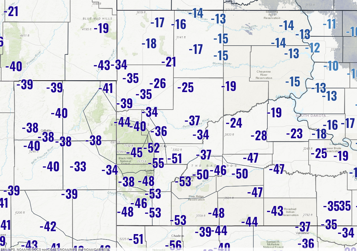 The 24-hour temperature change from 11 am MST Tuesday (Feb. 21) to 11 am MST Wednesday (Feb. 22). Note that some places dropped more than 50°F in less than 24 hours. |
Snowfall Map
| Storm total snowfall map for February 20-23, 2023 using the Iowa Environmental Mesonet plotting application. |
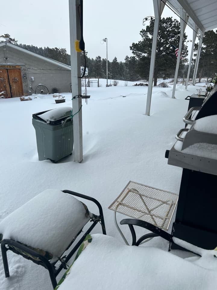
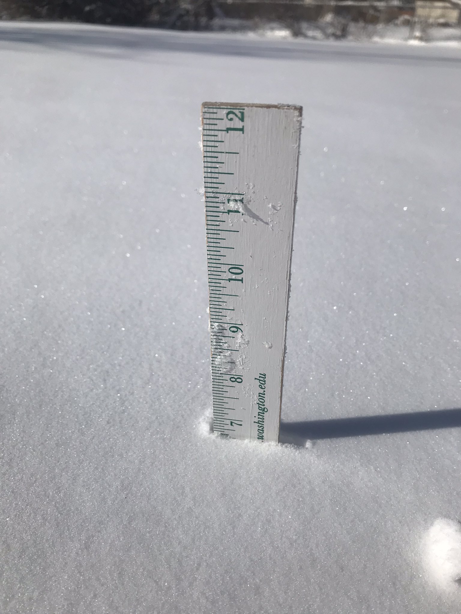
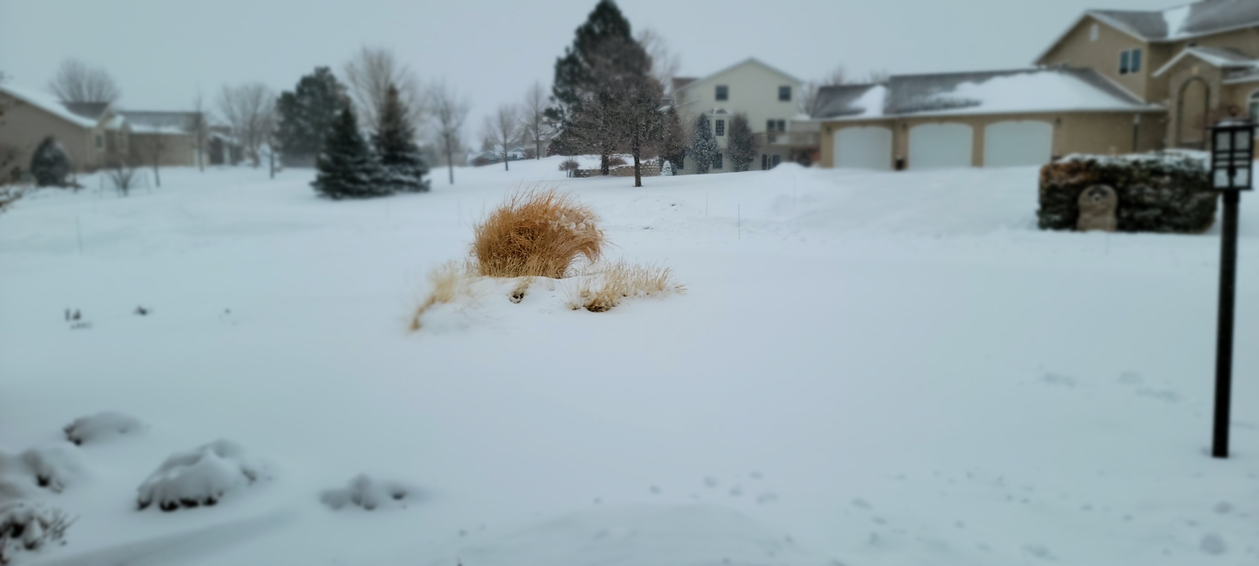
Photos
 |
 |
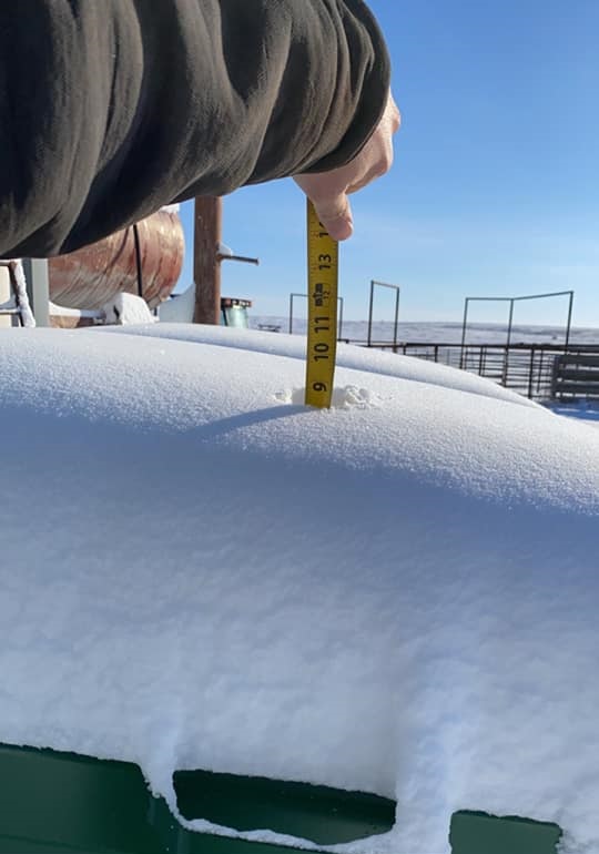 |
| 7 miles W of Hermosa (Mike & Theresa Ford) |
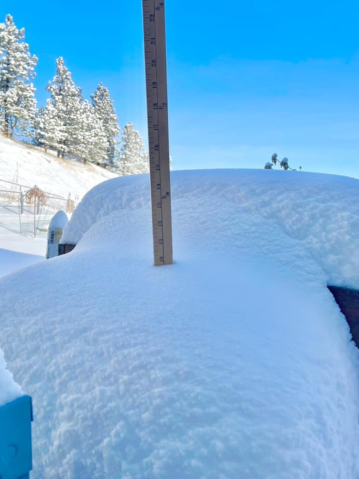
2 SSE of Downtown Rapid City (Jake Lindblom) |
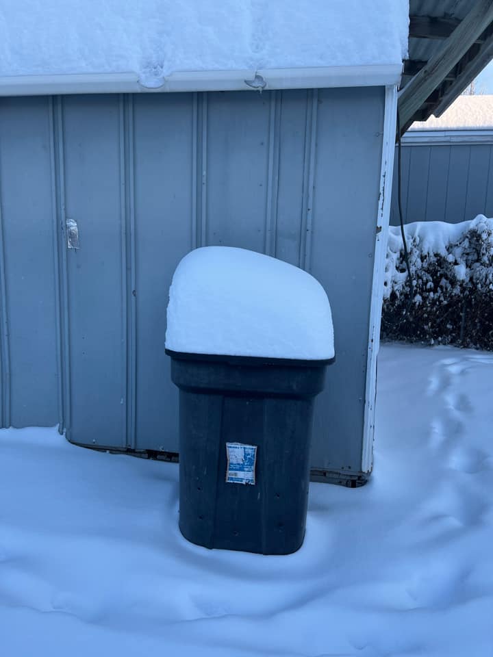
Caputa (Kevin Muilenburg) |
 |
 |
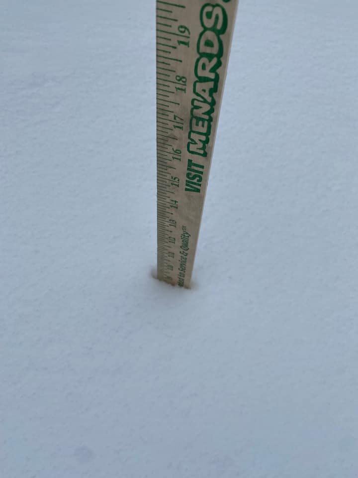 |
| Sturgis (Corey Kennedy) |
3 WSW of Downtown Rapid City (Leacey Brown) |
4 E of Rapid City (David Fitzpatrick) |
 |
| 7 miles SW of Rapid City (Eric Helgeson) |
Radar
Radar animation from 11 pm Monday, February 20th to 4 am Thursday, February 23rd, 2023. Blue shows snow and green shows rain.
Satellite, Etc.
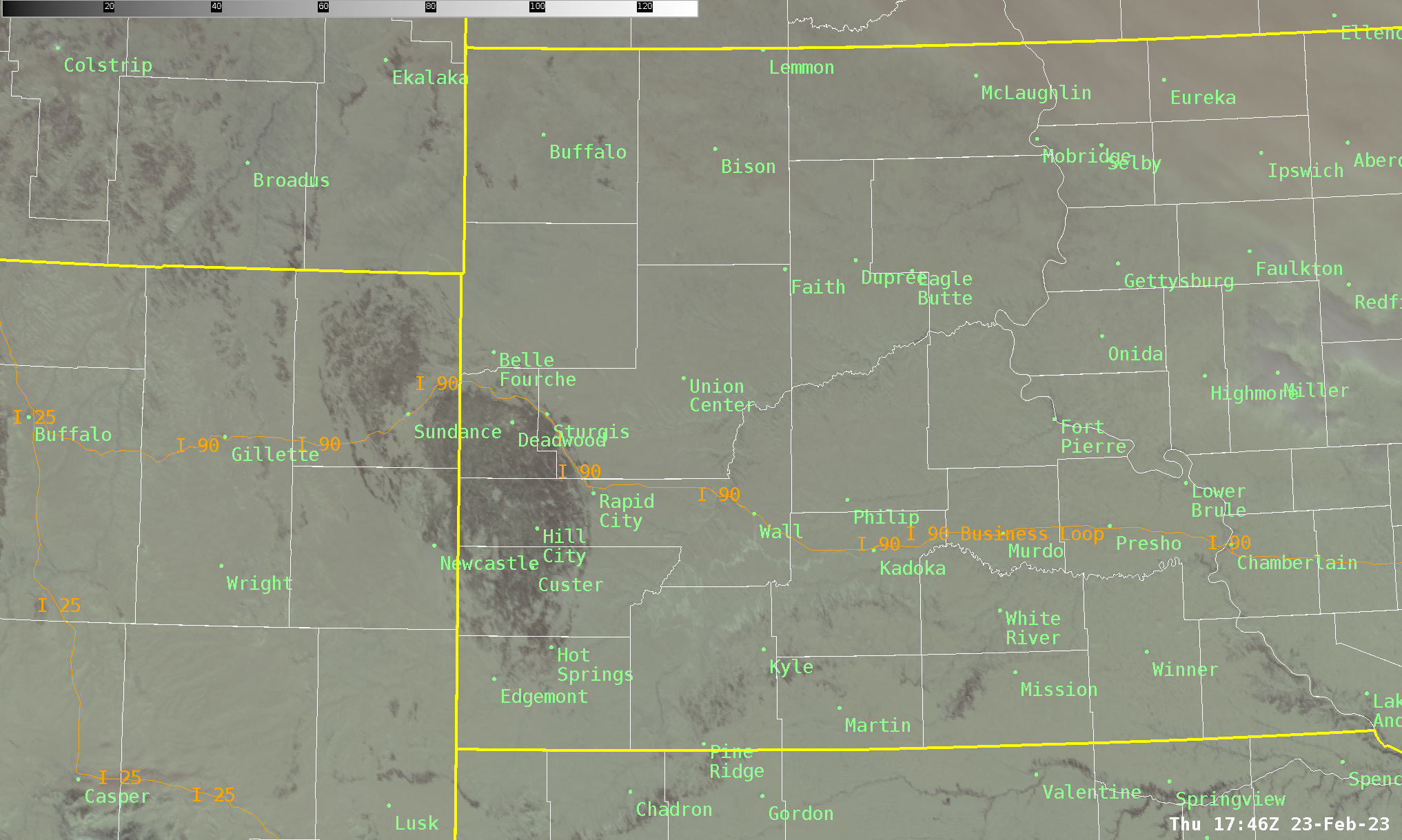 |
| Satellite image from 1046 am MST on February 23, 2023. This shows snow cover (grayish-white) across all of the field of view. Forested areas (such as the Black Hills and Pine Ridge) stand out as darker colors. |
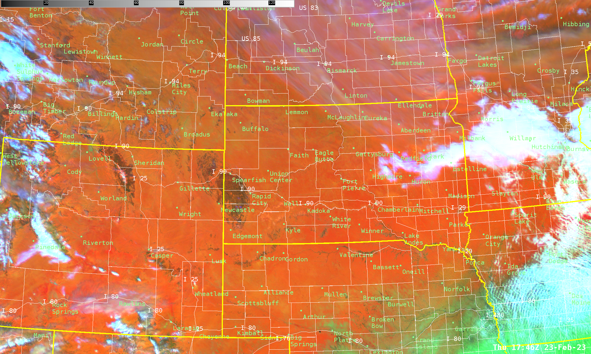 |
| Red-green-blue composite satellite image from 1046 am MST on February 23, 2023. This shows snow cover (red) across much of the region. Clouds appear as white and bare ground as green (as in the southeastern part of the image). |
 |
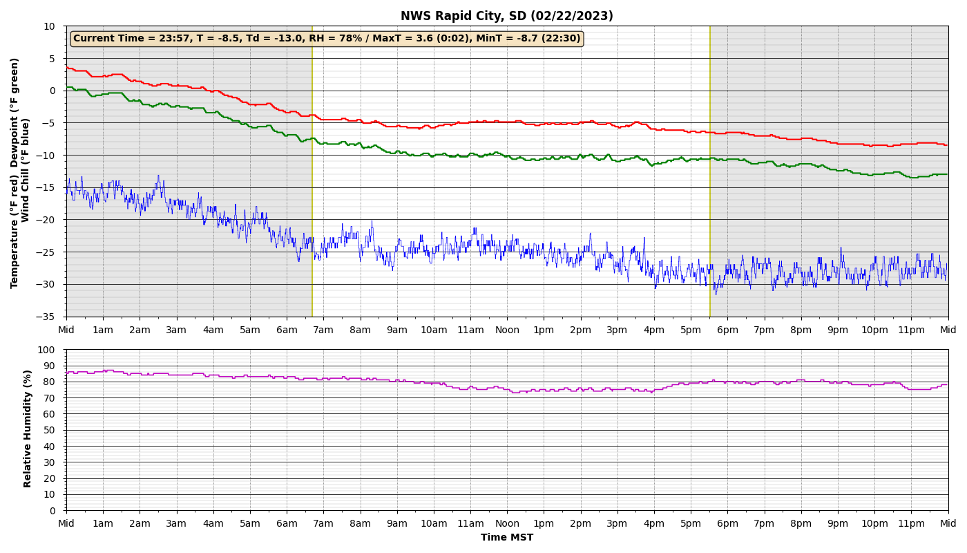 |
| Temperature trace (red) for NWS Rapid City on Tuesday, February 21, 2023. Note the high temperature of 50°F at 9:48 am MST, followed by an abrupt decline after 1:30 pm, reaching 3.6°F by midnight. | Temperature trace (red) for NWS Rapid City on Wednesday, February 22, 2023. Note the high temperature of 3.6°F was reached at midnight, and then the temperature was slowly declining or steady for the rest of the day. |
 |
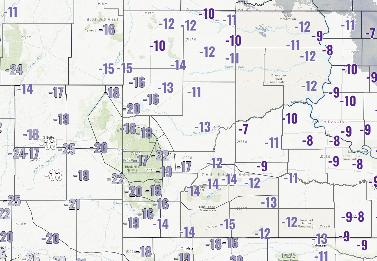 |
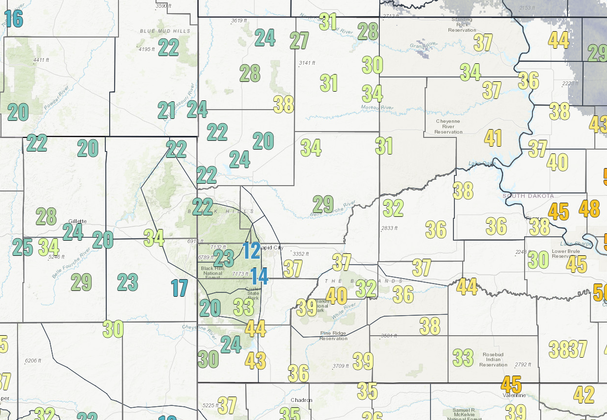
| Maximum wind gusts (mph) on Wednesday, February 22, 2023. | Minimum air temperature on Thursday morning, February 23, 2023. |
Storm Reports
...PRELIMINARY SNOW AND SLEET TOTALS (AT LEAST 0.1 INCH) SORTED BY MAGNITUDE...

LOCATION                      SNOWFALL    COMMENTS
                               IN/S/

Dwtn Gillette WY               17.0        817 AM 2/23/2023
6 NE Summerset SD              15.0        700 AM 2/23/2023
1 W O`Neil Pass SD             15.0        700 AM 2/23/2023
Lead SD                        12.5        800 AM 2/23/2023
1 NW Wasta SD                  12.0        752 AM 2/23/2023
8 NNW Newcastle WY             12.0        700 AM 2/23/2023
7 W Hermosa SD                 12.0        834 AM 2/23/2023
2 NNW Saint Onge SD            12.0       1056 AM 2/23/2023
3 SE Saint Onge SD             11.6        515 AM 2/23/2023
5 SSE Dwtn Spearfish SD        11.5        720 AM 2/23/2023
1 SW Rockerville SD            11.0        740 AM 2/23/2023
Wright WY                      11.0        700 AM 2/23/2023
2 E Cottonwood SD              11.0        750 AM 2/23/2023
4 NNE Summerset SD             10.1        600 AM 2/23/2023
5 NE Milesville SD             10.0        600 PM 2/23/2023
8 E Martin SD                  10.0       1125 AM 2/23/2023
1 E Vale SD                    10.0        922 AM 2/23/2023
7 N Wood SD                     9.8        600 AM 2/23/2023
Sturgis SD                      9.8       1055 AM 2/23/2023
Black Hawk SD                   9.8        712 AM 2/23/2023
4 NE Rockerville SD             9.7        641 AM 2/23/2023
Argyle SD                       9.5        710 AM 2/23/2023
7 NNE Ellsworth AFB SD          9.5        700 AM 2/23/2023
4 S Dwtn Rapid City SD          9.4        700 AM 2/23/2023
1 NE Upton WY                   9.3        800 AM 2/23/2023
5 ENE Custer SD                 9.2        700 AM 2/23/2023
9 ENE Wewela SD                 9.0        600 AM 2/23/2023
19 S Quinn SD                   9.0       1130 AM 2/23/2023
1 SSE White River SD            9.0        758 AM 2/23/2023
19 NNE Creighton SD             9.0        700 AM 2/23/2023
5 WSW Martin SD                 9.0       1100 AM 2/23/2023
3 WSW Dwtn Rapid City SD        9.0       1145 AM 2/23/2023
Piedmont SD                     9.0        352 PM 2/23/2023
2 SSW Norris SD                 9.0        700 AM 2/23/2023
3 S Dwtn Rapid City SD          9.0        550 AM 2/23/2023
4 E Dwtn Rapid City SD          9.0       1215 PM 2/23/2023
1 ESE Pactola Resv SD           8.7        800 AM 2/23/2023
1 E Dwtn Rapid City SD          8.5        455 AM 2/23/2023
11 NE Morrisey WY               8.5        700 AM 2/23/2023
Caputa SD                       8.5        824 AM 2/23/2023
5 ESE Norris SD                 8.5        651 AM 2/23/2023
Sundance WY                     8.5        600 AM 2/23/2023
1 NNW Dwtn Spearfish SD         8.5        900 AM 2/23/2023
6 NNW Dwtn Spearfish SD         8.4        700 AM 2/23/2023
1 SSE Dwtn Spearfish SD         8.4        800 AM 2/23/2023
5 NNW Custer SD                 8.0       1200 PM 2/23/2023
3 ENE Kyle SD                   8.0       1120 AM 2/23/2023
4 WNW Cedar Butte SD            8.0        756 AM 2/23/2023
4 W Dwtn Rapid City SD          8.0        700 AM 2/23/2023
8 W Dwtn Rapid City SD          8.0       1115 AM 2/23/2023
Mount Rushmore SD               8.0       1158 PM 2/22/2023
2 SSW Rapid City Arpt SD        8.0        800 AM 2/23/2023
Newell SD                       8.0        800 AM 2/23/2023
Interior SD                     8.0       1200 PM 2/23/2023
1 NNW Nisland SD                8.0        737 AM 2/23/2023
Hill City SD                    7.8        600 AM 2/23/2023
4 NNW Tilford SD                7.8        800 AM 2/23/2023
1 NE Dwtn Rapid City SD         7.7        600 AM 2/23/2023
6 W Hermosa SD                  7.5        700 AM 2/23/2023
12 S Quinn SD                   7.5        800 AM 2/23/2023
Hot Springs SD                  7.5        700 AM 2/23/2023
2 SSE Dwtn Rapid City SD        7.3        700 AM 2/23/2023
3 NE Hisega SD                  7.0        700 AM 2/23/2023
4 NE Wood SD                    7.0       1100 AM 2/23/2023
1 N Hisega SD                   7.0        700 AM 2/23/2023
2 WNW Dwtn Rapid City SD        7.0        700 AM 2/23/2023
7 E Sturgis SD                  7.0        741 AM 2/23/2023
1 SW Dwtn Rapid City SD         7.0        800 AM 2/23/2023
6 SW Beulah WY                  7.0        800 AM 2/23/2023
4 NW Parmelee SD                6.5        700 AM 2/23/2023
6 ENE Martin SD                 6.0       1120 AM 2/23/2023
2 WSW Hamill SD                 6.0        759 AM 2/23/2023
14 NNW Edgemont SD              6.0        747 AM 2/23/2023
9 NW Deerfield SD               6.0        738 AM 2/23/2023
Edgemont SD                     5.5        700 AM 2/23/2023
14 NNW Dwtn Gillette WY         5.2        700 AM 2/23/2023
9 N Cedar Butte SD              5.2        600 AM 2/23/2023
9 WSW Red Elm SD                5.0        802 AM 2/23/2023
7 SSE Cheyenne Crossing SD      5.0        740 AM 2/23/2023
4 NNW Elm Springs SD            5.0        600 AM 2/23/2023
Lemmon SD                       5.0        500 PM 2/23/2023
4 NW Dwtn Rapid City SD         5.0        600 AM 2/23/2023
1 NNE Edgemont SD               5.0        600 AM 2/23/2023
3 WNW Kadoka SD                 4.7        530 AM 2/23/2023
1 WNW Clareton WY               4.0        700 AM 2/23/2023
6 SSW Fairpoint SD              4.0        700 AM 2/23/2023
3 E Newcastle WY                4.0        600 AM 2/23/2023
Cedar Pass SD                   4.0        400 PM 2/23/2023
Tilford SD                      4.0        700 AM 2/23/2023
4 W Hot Springs SD              3.5        700 AM 2/23/2023
1 N Johnson Siding SD           3.4        800 AM 2/23/2023
4 SE Upton WY                   3.1        700 AM 2/23/2023
6 W New Underwood SD            3.0        700 AM 2/23/2023
14 SSW Provo SD                 3.0        800 AM 2/23/2023
Hermosa SD                      3.0        600 AM 2/23/2023
8 SE Mud Butte SD               3.0        800 AM 2/23/2023
10 W Reva SD                    2.0        730 AM 2/23/2023
14 WNW Lodgepole SD             2.0        734 AM 2/23/2023
 |
Media use of NWS Web News Stories is encouraged! Please acknowledge the NWS as the source of any news information accessed from this site. |
|