
Tropical Depression Two is expected to gradually strengthen and could bring tropical storm conditions to the Florida Panhandle beginning late Monday. Areas of flash flooding will be possible through Thursday along the eastern and central Gulf Coast. Severe thunderstorms will develop and move along a cold front crossing the Upper Midwest Monday, and through the Ohio Valley/Mid-Atlantic on Tuesday. Read More >
Overview
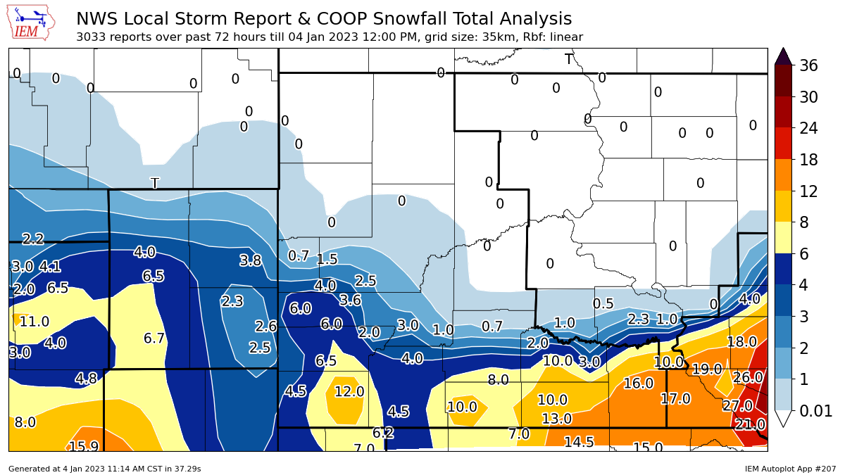
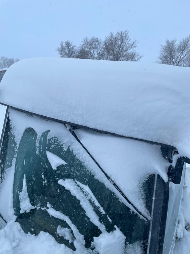
A vigorous upper level low emerged from the western United States January 1, 2023. As it moved into the central plains, it wrapped up over Nebraska injecting significant amounts of moisture into northeastern Wyoming and western South Dakota. Snow started the evening of January 1 and persisted until the morning of January 3. The heaviest snow fell from Martin to Rosebud to Winner, South Dakota, although there was a heavier pocket south of Hot Springs, SD and south of Gillette, WY. Little to no snow fell north of Interstate 90 over northwestern South Dakota. The one nice thing about this winter storm was that winds were relatively tame. The snow fell straight down at our office in Rapid City, SD.
Snow
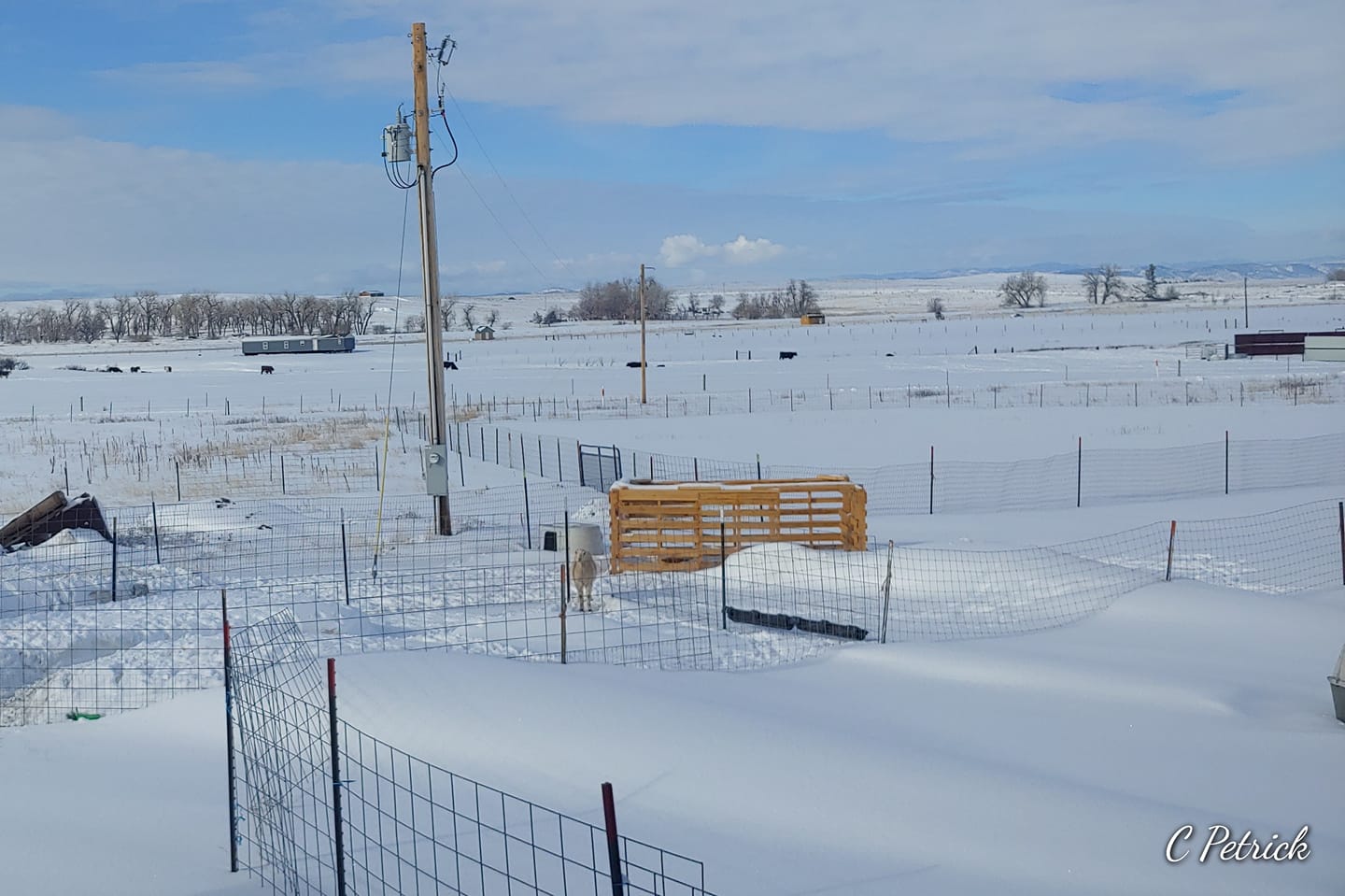
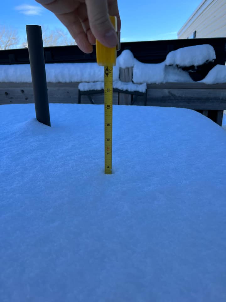
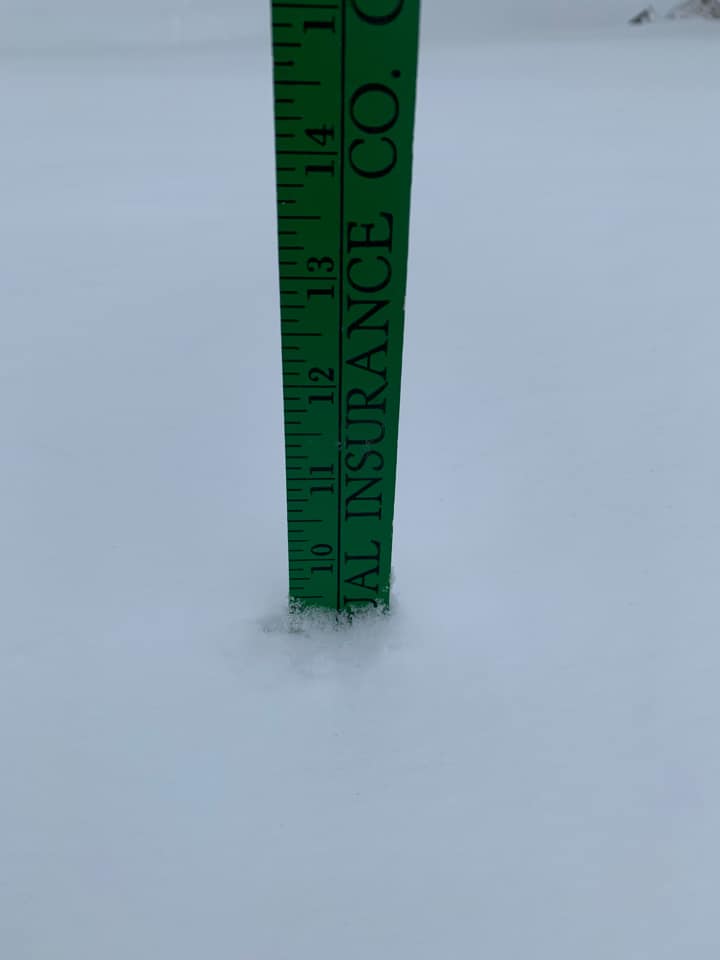
Photos
 |
 |
 |
 |
| Smithwick, SD (Courtesy: Charlie P.) |
Gillette, WY (Courtesy: Aaron M.) |
Rosebud, SD (Courtesy: Madison A.) |
Winner, SD (Courtesy: Brook & Dustin F.) |
Radar
Storm Reports
PUBLIC INFORMATION STATEMENT
NATIONAL WEATHER SERVICE RAPID CITY SD
650 PM MST TUE JAN 03 2023

THE FOLLOWING ARE UNOFFICIAL OBSERVATIONS TAKEN DURING THE PAST 72
HOURS

********************STORM TOTAL SNOWFALL********************

LOCATION                TOTAL      TIME/DATE  COMMENTS
                     SNOWFALL       MEASURED
                     (INCHES)

SOUTH DAKOTA

...BENNETT COUNTY...
  2 E SWETT              10.0   208 PM  1/03  TRAINED SPOTTER
  8 WSW SWETT             8.0   132 PM  1/03  STORM TOTAL
  8 E MARTIN              7.0   600 AM  1/03  CO-OP OBSERVER
  MARTIN                  5.0  1145 AM  1/03  SOCIAL MEDIA

...CUSTER COUNTY...
  1 WNW WIND CAVE VISI    6.5   100 PM  1/03  CO-OP OBSERVER
  10 E CUSTER             5.8   729 AM  1/03  COCORAHS
  1 SW HERMOSA            5.0   334 PM  1/02  TRAINED SPOTTER
  ARGYLE                  4.5   942 AM  1/03  TRAINED SPOTTER
  5 WNW HERMOSA           4.0   403 PM  1/02  STILL LIGHTLY SNOWING.
  3 SSW ARGYLE            3.5   700 AM  1/03  COCORAHS
  1 NW HERMOSA            3.5   700 AM  1/03  COCORAHS
  5 ENE CUSTER            3.0  1230 PM  1/02  TRAINED SPOTTER
  7 WSW FOLSOM            2.0   500 AM  1/03  COCORAHS

...FALL RIVER COUNTY...
  SMITHWICK              12.0   117 PM  1/03  STORM TOTAL SNOWFALL
  OELRICHS                9.0   155 PM  1/03  STORM TOTAL
  8 E SMITHWICK           7.0   143 PM  1/03  TRAINED SPOTTER
  HOT SPRINGS             6.5   700 AM  1/03  COCORAHS
  4 W HOT SPRINGS         6.0   700 AM  1/03  COCORAHS
  ORAL                    6.0   600 AM  1/03  CO-OP OBSERVER
  1 NNE EDGEMONT          4.5   600 AM  1/03  CO-OP OBSERVER
  2 ENE EDGEMONT          3.4   700 AM  1/03  COCORAHS
  EDGEMONT                3.0   700 AM  1/03  COCORAHS
  14 NW EDGEMONT          3.0   800 AM  1/03  COCORAHS

...JACKSON COUNTY...
  4 S LONG VALLEY         8.0   212 PM  1/03  TRAINED SPOTTER
  6 WSW LONG VALLEY       5.0   214 PM  1/03  TRAINED SPOTTER
  9 SSE POTATO CREEK      4.0   211 PM  1/03  TRAINED SPOTTER
  3 WNW KADOKA            0.9   530 AM  1/03  COCORAHS

...LAWRENCE COUNTY...
  NEMO                    4.0   320 PM  1/02  SOCIAL MEDIA
  LEAD                    1.5   800 AM  1/03  CO-OP OBSERVER
  5 SSE DWTN SPEARFISH    0.9   725 AM  1/03  COCORAHS
  1 SSE DWTN SPEARFISH    0.7   800 AM  1/03  COCORAHS
  3 SE SAINT ONGE         0.6   615 AM  1/03  COCORAHS
  2 WNW DWTN SPEARFISH    0.5   700 AM  1/03  COCORAHS
  1 NNW DWTN SPEARFISH    0.3   900 AM  1/03  CO-OP OBSERVER
  6 NNW DWTN SPEARFISH    0.1   700 AM  1/03  COCORAHS

...MEADE COUNTY...
  BLACK HAWK              4.0   409 PM  1/02  EMERGENCY MANAGER
  7 NNE ELLSWORTH AFB     3.0   700 AM  1/03  COCORAHS
  4 NNE SUMMERSET         2.7   615 AM  1/03  COCORAHS
  6 NE SUMMERSET          1.5   700 AM  1/03  COCORAHS
  2 E STURGIS             1.5   600 PM  1/02  CO-OP OBSERVER
  4 NNW TILFORD           1.5   800 AM  1/03  COCORAHS

...MELLETTE COUNTY...
  3 W WHITE RIVER        10.0   100 PM  1/03  TRAINED SPOTTER
  5 ESE NORRIS            6.4  1144 AM  1/03  TRAINED SPOTTER
  3 SSE WHITE RIVER       6.0   340 PM  1/03  TRAINED SPOTTER
  2 SSW NORRIS            5.0   700 AM  1/03  COCORAHS
  7 N WOOD                3.0   600 AM  1/03  COCORAHS
  4 NE WOOD               3.0   800 AM  1/03  COCORAHS
  9 N CEDAR BUTTE         2.0   600 AM  1/03  COCORAHS

...OGLALA LAKOTA COUNTY...
  3 ENE KYLE              6.0   600 AM  1/03  CO-OP OBSERVER
  KYLE                    6.0   146 PM  1/03  STORM TOTAL
  5 E PORCUPINE           5.0   137 PM  1/03  STORM TOTAL
  6 SE OGLALA             4.5   129 PM  1/03  STORM TOTAL
  PINE RIDGE              4.0   123 PM  1/03  TRAINED SPOTTER
  7 N ROCKYFORD           4.0   205 PM  1/03  PUBLIC

...PENNINGTON COUNTY...
  1 S KEYSTONE            6.0  1236 PM  1/03  SOCIAL MEDIA
  3 SE DEERFIELD          6.0  1230 PM  1/02  TRAINED SPOTTER
  HILL CITY               4.7   600 AM  1/03  CO-OP OBSERVER
  1 N HISEGA              4.5   700 AM  1/03  COCORAHS
  4 S DWTN RAPID CITY     4.4   700 AM  1/03  COCORAHS
  1 N JOHNSON SIDING      4.4   800 AM  1/03  COCORAHS
  3 NE HISEGA             4.3   700 AM  1/03  COCORAHS
  MOUNT RUSHMORE          4.0  1158 PM  1/02  CO-OP OBSERVER
  4 NE ROCKERVILLE        4.0   820 PM  1/02  NWS EMPLOYEE
  1 ESE PACTOLA RESV      4.0   800 AM  1/03  CO-OP OBSERVER
  3 NNE JOHNSON SIDING    3.7   700 AM  1/03  COCORAHS
  1 E DWTN RAPID CITY     3.6  1100 PM  1/02  OFFICIAL NWS OBS
  4 W DWTN RAPID CITY     3.4   700 AM  1/03  COCORAHS
  4 NW DWTN RAPID CITY    3.0   600 AM  1/03  CO-OP OBSERVER
  5 N SCENIC              3.0   311 PM  1/03  STORM TOTAL SNOW
  2 SSE DWTN RAPID CIT    3.0   700 AM  1/03  COCORAHS
  6 W NEW UNDERWOOD       2.1   700 AM  1/03  COCORAHS
  12 S QUINN              1.0   800 AM  1/03  COCORAHS
  4 WNW RAPID CITY ARP    0.5   700 AM  1/03  COCORAHS

...TODD COUNTY...
  16 SSE MISSION         16.0   600 AM  1/03  COCORAHS
  7 SE SAINT FRANCIS     13.0   226 PM  1/03  EMERGENCY MANAGER
  S ROSEBUD              10.0  1212 PM  1/03  SOCIAL MEDIA

...TRIPP COUNTY...
  9 ENE WEWELA           19.0   600 AM  1/03  COCORAHS
  N WINNER               16.0   251 PM  1/03  SOCIAL MEDIA
  1 ENE MILLBORO         12.0  1200 PM  1/03  TRAINED SPOTTER

WYOMING

...CAMPBELL COUNTY...
  WRIGHT                  6.7   700 AM  1/03  2 DAY STORM TOTAL
  1 S DWTN GILLETTE       6.5  1124 PM  1/02  SOCIAL MEDIA
  1 SE DWTN GILLETTE      6.0   111 PM  1/03  STORM TOTAL SNOWFALL
  14 NNW DWTN GILLETTE    4.5   700 AM  1/03  COCORAHS
  4 SE GILLETTE           1.2   430 PM  1/03  CO-OP OBSERVER

...CROOK COUNTY...
  SUNDANCE                4.3   600 AM  1/03  COCORAHS
  6 SW BEULAH             2.0   800 AM  1/03  COCORAHS

...WESTON COUNTY...
  8 NNW NEWCASTLE         4.5   700 AM  1/03  COCORAHS
  11 NE MORRISEY          3.0   700 AM  1/03  COCORAHS
  1 SE NEWCASTLE          2.6   800 AM  1/03  COCORAHS
  1 ESE NEWCASTLE         2.6   800 AM  1/03  CO-OP OBSERVER
  4 SE UPTON              2.3   700 AM  1/02  COCORAHS


...PRELIMINARY SNOW AND SLEET TOTALS SORTED BY MAGNITUDE...

LOCATION                      SNOWFALL    COMMENTS
                               IN/S/

9 ENE WEWELA SD                19.0        600 AM 1/03/2023
N WINNER SD                    16.0        251 PM 1/03/2023
16 SSE MISSION SD              16.0        600 AM 1/03/2023
7 SE SAINT FRANCIS SD          13.0        226 PM 1/03/2023
1 ENE MILLBORO SD              12.0       1200 PM 1/03/2023
SMITHWICK SD                   12.0        117 PM 1/03/2023
S ROSEBUD SD                   10.0       1212 PM 1/03/2023
2 E SWETT SD                   10.0        208 PM 1/03/2023
3 W WHITE RIVER SD             10.0        100 PM 1/03/2023
OELRICHS SD                     9.0        155 PM 1/03/2023
8 WSW SWETT SD                  8.0        132 PM 1/03/2023
4 S LONG VALLEY SD              8.0        212 PM 1/03/2023
8 E SMITHWICK SD                7.0        143 PM 1/03/2023
8 E MARTIN SD                   7.0        600 AM 1/03/2023
WRIGHT WY                       6.7        700 AM 1/03/2023
1 WNW WIND CAVE VISITORS CENT   6.5        100 PM 1/03/2023
1 S DWTN GILLETTE WY            6.5       1124 PM 1/02/2023
HOT SPRINGS SD                  6.5        700 AM 1/03/2023
5 ESE NORRIS SD                 6.4       1144 AM 1/03/2023
3 ENE KYLE SD                   6.0        600 AM 1/03/2023
KYLE SD                         6.0        146 PM 1/03/2023
4 W HOT SPRINGS SD              6.0        700 AM 1/03/2023
ORAL SD                         6.0        600 AM 1/03/2023
1 S KEYSTONE SD                 6.0       1236 PM 1/03/2023
3 SSE WHITE RIVER SD            6.0        340 PM 1/03/2023
1 SE DWTN GILLETTE WY           6.0        111 PM 1/03/2023
3 SE DEERFIELD SD               6.0       1230 PM 1/02/2023
10 E CUSTER SD                  5.8        729 AM 1/03/2023
1 SW HERMOSA SD                 5.0        334 PM 1/02/2023
5 E PORCUPINE SD                5.0        137 PM 1/03/2023
MARTIN SD                       5.0       1145 AM 1/03/2023
6 WSW LONG VALLEY SD            5.0        214 PM 1/03/2023
2 SSW NORRIS SD                 5.0        700 AM 1/03/2023
HILL CITY SD                    4.7        600 AM 1/03/2023
ARGYLE SD                       4.5        942 AM 1/03/2023
6 SE OGLALA SD                  4.5        129 PM 1/03/2023
14 NNW DWTN GILLETTE WY         4.5        700 AM 1/03/2023
1 N HISEGA SD                   4.5        700 AM 1/03/2023
8 NNW NEWCASTLE WY              4.5        700 AM 1/03/2023
1 NNE EDGEMONT SD               4.5        600 AM 1/03/2023
4 S DWTN RAPID CITY SD          4.4        700 AM 1/03/2023
1 N JOHNSON SIDING SD           4.4        800 AM 1/03/2023
3 NE HISEGA SD                  4.3        700 AM 1/03/2023
SUNDANCE WY                     4.3        600 AM 1/03/2023
9 SSE POTATO CREEK SD           4.0        211 PM 1/03/2023
5 WNW HERMOSA SD                4.0        403 PM 1/02/2023
MOUNT RUSHMORE SD               4.0       1158 PM 1/02/2023
4 NE ROCKERVILLE SD             4.0        820 PM 1/02/2023
PINE RIDGE SD                   4.0        123 PM 1/03/2023
NEMO SD                         4.0        320 PM 1/02/2023
1 ESE PACTOLA RESV SD           4.0        800 AM 1/03/2023
BLACK HAWK SD                   4.0        409 PM 1/02/2023
7 N ROCKYFORD SD                4.0        205 PM 1/03/2023
3 NNE JOHNSON SIDING SD         3.7        700 AM 1/03/2023
1 E DWTN RAPID CITY SD          3.6       1100 PM 1/02/2023
3 SSW ARGYLE SD                 3.5        700 AM 1/03/2023
1 NW HERMOSA SD                 3.5        700 AM 1/03/2023
2 ENE EDGEMONT SD               3.4        700 AM 1/03/2023
4 W DWTN RAPID CITY SD          3.4        700 AM 1/03/2023
7 N WOOD SD                     3.0        600 AM 1/03/2023
4 NE WOOD SD                    3.0        800 AM 1/03/2023
11 NE MORRISEY WY               3.0        700 AM 1/03/2023
EDGEMONT SD                     3.0        700 AM 1/03/2023
14 NW EDGEMONT SD               3.0        800 AM 1/03/2023
4 NW DWTN RAPID CITY SD         3.0        600 AM 1/03/2023
5 ENE CUSTER SD                 3.0       1230 PM 1/02/2023
5 N SCENIC SD                   3.0        311 PM 1/03/2023
7 NNE ELLSWORTH AFB SD          3.0        700 AM 1/03/2023
2 SSE DWTN RAPID CITY SD        3.0        700 AM 1/03/2023
4 NNE SUMMERSET SD              2.7        615 AM 1/03/2023
1 SE NEWCASTLE WY               2.6        800 AM 1/03/2023
1 ESE NEWCASTLE WY              2.6        800 AM 1/03/2023
4 SE UPTON WY                   2.3        700 AM 1/02/2023
6 W NEW UNDERWOOD SD            2.1        700 AM 1/03/2023
7 WSW FOLSOM SD                 2.0        500 AM 1/03/2023
9 N CEDAR BUTTE SD              2.0        600 AM 1/03/2023
6 SW BEULAH WY                  2.0        800 AM 1/03/2023
6 NE SUMMERSET SD               1.5        700 AM 1/03/2023
2 E STURGIS SD                  1.5        600 PM 1/02/2023
4 NNW TILFORD SD                1.5        800 AM 1/03/2023
LEAD SD                         1.5        800 AM 1/03/2023
4 SE GILLETTE WY                1.2        430 PM 1/03/2023
12 S QUINN SD                   1.0        800 AM 1/03/2023
3 WNW KADOKA SD                 0.9        530 AM 1/03/2023
5 SSE DWTN SPEARFISH SD         0.9        725 AM 1/03/2023
1 SSE DWTN SPEARFISH SD         0.7        800 AM 1/03/2023
3 SE SAINT ONGE SD              0.6        615 AM 1/03/2023
2 WNW DWTN SPEARFISH SD         0.5        700 AM 1/03/2023
4 WNW RAPID CITY ARPT SD        0.5        700 AM 1/03/2023
1 NNW DWTN SPEARFISH SD         0.3        900 AM 1/03/2023
6 NNW DWTN SPEARFISH SD         0.1        700 AM 1/03/2023

$$

WONG
 |
Media use of NWS Web News Stories is encouraged! Please acknowledge the NWS as the source of any news information accessed from this site. |
|

