
Tropical Depression Two is expected to gradually strengthen and could bring tropical storm conditions to the Florida Panhandle beginning late Monday. Areas of flash flooding will be possible through Thursday along the eastern and central Gulf Coast. Severe thunderstorms will develop and move along a cold front crossing the Upper Midwest Monday, and through the Ohio Valley/Mid-Atlantic on Tuesday. Read More >
Overview
|
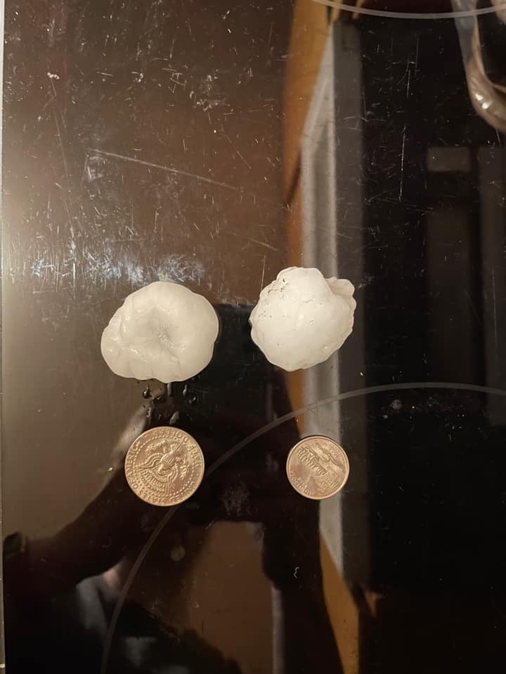
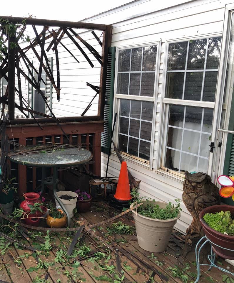
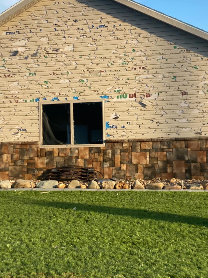
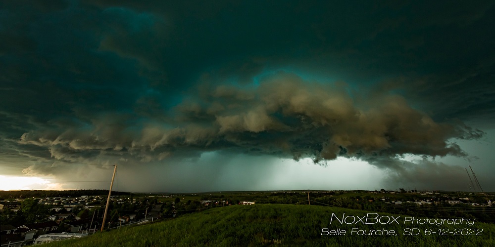
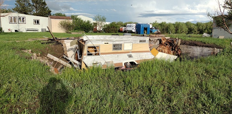
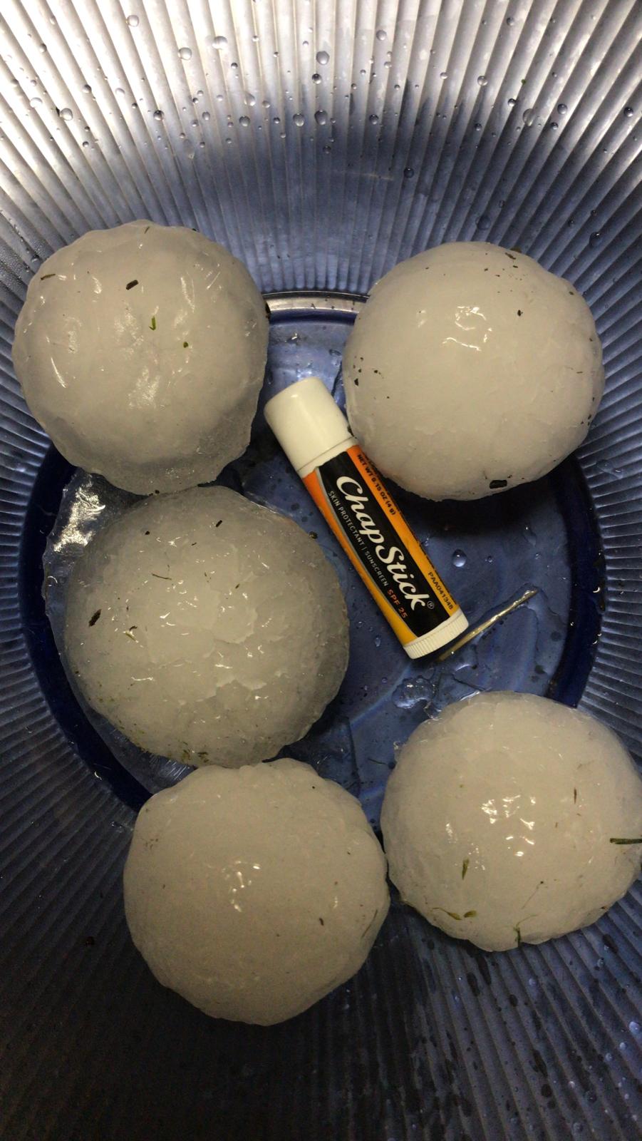
Three days in a row, our area was affected by severe thunderstorms. On June 11, thunderstorms moved into northwestern SD and northeastern WY from MT. They brought large hail and damaging winds; in particular, Philip received significant wind damage, with roofs being blown off buildings. On June 12, another round of thunderstorms brought very large hail and strong winds that damaged areas from northeastern WY to central SD. Belle Fourche received quite a bit of damage from Sunday's storms, which involved wind-driven hail, up to grapefruit size (4 inches). Slightly larger (4.5 inches, softball sized) hail was reported near Wall later. On June 13, storms started across northeastern WY along a cold front, and traveled through western SD during the evening. The largest hail (the size of a grapefruit) was reported in the Hot Springs/Buffalo Gap area. Later, tennis ball sized hail driven by 90 mph winds caused damage in Kadoka. |
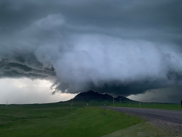 June 11 storm over Bear Butte (Markus Erk) |
Photos & Video
Saturday, June 11
 |
 |
 |
 |
| East of Sturgis (K. Louise) |
Belle Fourche Reservoir (A. Kaye) |
Nisland (B. Jones) |
Nisland (B. Jones) |
Sunday, June 12
 |
 |
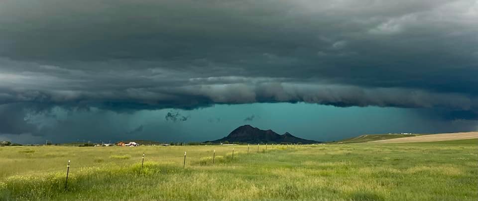
| Bear Butte (R. Gutknecht) |
13 N Wicksville (S. Ornelas) |
 |
 |
 |
 |
| 23 mi N Wall (C. Shearer) |
2 S Belle Fourche (A. Schulze) |
Belle Fourche (C. Evan Woolston) |
Belle Fourche (K. Hoffmann) |
 |
 |
| Belle Fourche (R. Olson) |
Belle Fourche (J. R. Newlander-White Buffalo) |
 |
 |
 |
 |
| East of Sturgis (M. Ann) |
Belle Fourche (S. Armlin) |
Lead (P. Elizabeth) |
New Haven (H. Bohl) |
Monday, June 13
 |
 |
 |
 |
| Hot Springs (P.S. Jones) |
Hot Springs (D. Airheart) |
Hot Springs (D. Airheart) |
Hot Springs (P.S. Jones) |
Hot Springs in South Dakota has been smashed by up to 3.25"+ hail this evening after a severe storm moved through. Numerous cars have lost their windows. @NWSRapidCity #sdwx pic.twitter.com/rp6HaSGz2T
— Daniel Shaw (@DanielShawAU) June 14, 2022
LARGE HAIL up to 3” in diameter in Hot Springs, SD @NWSRapidCity @brianvotoole pic.twitter.com/2bVLkkiR10
— Reed Timmer (@ReedTimmerAccu) June 14, 2022
Hail along I-90 and Bigfoot pass road. Est. 2-2.5” in diameter, quarter for comparison. #sdwx @NWSRapidCity pic.twitter.com/Xe41WmzUQi
— Jim Tang (@wxmann) June 14, 2022
Pretty big hail with this storm too! East of Wall, SD! #sdwx @NWSRapidCity pic.twitter.com/qoXQyJP5y0
— Tanner Charles 🌪 (@TannerCharlesMN) June 14, 2022
Radar
Saturday, June 11
Sunday, June 12
Monday, June 13
Severe storms moving through Hot Springs
Severe storms moving through Kadoka
Storm Reports
Saturday, June 11
...MAXIMUM OBSERVED WINDS (AT LEAST 50 MPH) SORTED BY MAGNITUDE...

LOCATION                      MAX WIND    COMMENTS
                               MPH

12 WSW Castle Rock SD            92        827 PM 6/11/2022
7 E Sturgis SD                   80        905 PM 6/11/2022
2 N Belle Fourche SD             73        821 PM 6/11/2022
Four Corners WY                  72        952 PM 6/11/2022
3 NW Wasta SD                    70        959 PM 6/11/2022
6 W Parmelee SD                  68        102 AM 6/12/2022
4 E Cactus Flat SD               66       1023 PM 6/11/2022
1 SW Newell SD                   66        920 PM 6/11/2022
1 NE Midland SD                  64       1102 PM 6/11/2022
2 E Cottonwood SD                63       1025 PM 6/11/2022
1 SSE White River SD             61       1125 PM 6/11/2022
3 WSW Fairburn SD                58       1107 PM 6/11/2022
15 SSE Mission SD                56        135 AM 6/12/2022
8 SSW Folsom SD                  55       1129 PM 6/11/2022
8 S Wall SD                      54       1020 PM 6/11/2022
7 E Wanblee SD                   52       1240 AM 6/12/2022


...MAXIMUM HAIL SIZE (AT LEAST 0.5 INCH) SORTED BY MAGNITUDE...

LOCATION                      MAX SIZE    COMMENTS
                               IN/S/

17 E Sturgis SD                2.00        910 PM 6/11/2022
2 SE Nisland SD                2.00        845 PM 6/11/2022
6 N Belle Fourche SD           2.00        825 PM 6/11/2022
Mount Rushmore SD              1.75       1046 PM 6/11/2022
5 W Hermosa SD                 1.75       1100 PM 6/11/2022
Belle Fourche Resv SD          1.50        830 PM 6/11/2022
Hill City SD                   1.50       1032 PM 6/11/2022
Nisland SD                     1.50        840 PM 6/11/2022
2 W Vale SD                    1.25        848 PM 6/11/2022
2 WSW Vale SD                  1.25        848 PM 6/11/2022
13 N Sturgis SD                1.25        845 PM 6/11/2022
Keystone SD                    1.00       1045 PM 6/11/2022
5 NNE Upton WY                 1.00        938 PM 6/11/2022
1 NNE Hulett WY                1.00        922 PM 6/11/2022
Colony WY                      1.00        805 PM 6/11/2022
5 WNW Hermosa SD               1.00       1055 PM 6/11/2022
4 SW Dwtn Rapid City SD        0.50       1050 PM 6/11/2022
3 SE Dwtn Rapid City SD        0.50       1055 PM 6/11/2022
Sunday, June 12
...PRELIMINARY RAINFALL TOTALS (AT LEAST 0.75 INCH) SORTED BY MAGNITUDE...

LOCATION                      TOTAL RAIN  COMMENTS
                               IN/S/

1 SW MIDLAND SD                2.49        609 AM 6/13/2022
3 NE WHITEWOOD SD              1.62        616 PM 6/12/2022
5 SSE ELM SPRINGS SD           1.48        609 AM 6/13/2022
4 NNW ELM SPRINGS SD           1.20        609 AM 6/13/2022
7 E COTTONWOOD SD              1.14        609 AM 6/13/2022
2 E COTTONWOOD SD              1.08        609 AM 6/13/2022
5 SSE RALPH SD                 0.90        609 AM 6/13/2022
5 NNE STONEVILLE SD            0.82        550 PM 6/12/2022
1 N BUFFALO SD                 0.79        609 AM 6/13/2022


...MAXIMUM OBSERVED WINDS (AT LEAST 50 MPH) SORTED BY MAGNITUDE...

LOCATION                      MAX WIND    COMMENTS
                               MPH

1 N SAINT ONGE SD                91        515 PM 6/12/2022
8 N REDIG SD                     84       1041 PM 6/12/2022
1 NNE FAITH SD                   77       1204 AM 6/13/2022
1 N BUFFALO SD                   77       1028 PM 6/12/2022
12 WSW CASTLE ROCK SD            73       1050 PM 6/12/2022
10 W REVA SD                     70       1045 PM 6/12/2022
2 E COTTONWOOD SD                67        820 PM 6/12/2022
5 NNW DWTN GILLETTE WY           66        424 PM 6/12/2022
11 SW PARMELEE SD                65        856 PM 6/12/2022
3 NW WASTA SD                    64        751 PM 6/12/2022
4 E CACTUS FLAT SD               61        816 PM 6/12/2022
7 WSW HOOVER SD                  59       1058 PM 6/12/2022
FOUR CORNERS WY                  57        612 PM 6/12/2022
6 W PARMELEE SD                  56        928 PM 6/12/2022
UNION CENTER SD                  56        620 PM 6/12/2022
15 SSE MISSION SD                56       1023 PM 6/12/2022
7 SSE MEADOW SD                  55       1150 PM 6/12/2022
10 ESE PINE HAVEN WY             55        522 PM 6/12/2022
1 WSW RED ELM SD                 54       1202 AM 6/13/2022
7 E WANBLEE SD                   54        858 PM 6/12/2022
8 E PRAIRIE CITY SD              54       1127 PM 6/12/2022
WASTA SD                         54        730 PM 6/12/2022
3 W UNION CENTER SD              54        613 PM 6/12/2022
1 SSW ROZET WY                   53        445 PM 6/12/2022
13 SSW REVA SD                   53       1115 PM 6/12/2022
3 ESE PINE RIDGE SD              51        818 PM 6/12/2022
3 W LEMMON SD                    51       1229 AM 6/13/2022
1 NE MIDLAND SD                  51       1216 AM 6/13/2022
PINE HAVEN WY                    51        508 PM 6/12/2022
1 ENE MUD BUTTE SD               50       1124 PM 6/12/2022
12 WSW HEREFORD SD               50        733 PM 6/12/2022


...MAXIMUM HAIL SIZE (AT LEAST 1.00 INCH) SORTED BY MAGNITUDE...

LOCATION                      MAX SIZE    COMMENTS
                               IN/S/

23 N WALL SD                   4.50        645 PM 6/12/2022
2 NW BELLE FOURCHE SD          4.00        500 PM 6/12/2022
6 NNE ALADDIN WY               2.75        440 PM 6/12/2022
2 NNW SAINT ONGE SD            2.75        526 PM 6/12/2022
1 NW STURGIS SD                2.00        640 PM 6/12/2022
5 E ELM SPRINGS SD             1.75        645 PM 6/12/2022
6 SSW ELM SPRINGS SD           1.75        803 PM 6/12/2022
4 E STURGIS SD                 1.75        644 PM 6/12/2022
5 N HULETT WY                  1.75        413 PM 6/12/2022
3 ENE STURGIS SD               1.75        642 PM 6/12/2022
3 NE WHITEWOOD SD              1.75        556 PM 6/12/2022
BELLE FOURCHE SD               1.50        459 PM 6/12/2022
15 NNW RECLUSE WY              1.50        300 PM 6/12/2022
5 E STURGIS SD                 1.50        700 PM 6/12/2022
DEADWOOD SD                    1.50        637 PM 6/12/2022
5 NE TILFORD SD                1.25        647 PM 6/12/2022
7 NNE TILFORD SD               1.25        647 PM 6/12/2022
LEAD SD                        1.25        630 PM 6/12/2022
1 SSW STURGIS SD               1.00        702 PM 6/12/2022
11 SSE WESTON WY               1.00        437 PM 6/12/2022
12 WSW HEREFORD SD             1.00        733 PM 6/12/2022
Monday, June 13
...PRELIMINARY RAINFALL TOTALS (AT LEAST 0.75 INCH) SORTED BY MAGNITUDE...

LOCATION                      TOTAL RAIN  COMMENTS
                               IN/S/

7 WSW FOLSOM SD                1.17        515 AM 6/14/2022
1 NNW NISLAND SD               1.11        611 AM 6/14/2022
1 SW MIDLAND SD                1.02        611 AM 6/14/2022
11 S FOLSOM SD                 0.81        611 AM 6/14/2022
9 S LUDLOW SD                  0.80        538 AM 6/14/2022
10 W REVA SD                   0.77        611 AM 6/14/2022


...MAXIMUM OBSERVED WINDS (AT LEAST 50 MPH) SORTED BY MAGNITUDE...

LOCATION                      MAX WIND    COMMENTS
                               MPH

KADOKA SD                        90       1210 AM 6/14/2022
7 E WANBLEE SD                   83       1201 AM 6/14/2022
3 NNW SCENIC SD                  74       1037 PM 6/13/2022
8 SSW FOLSOM SD                  60        934 PM 6/13/2022
4 E CACTUS FLAT SD               60       1155 PM 6/13/2022
15 SSE MISSION SD                60        157 AM 6/14/2022
1 SW NEWELL SD                   60        735 PM 6/13/2022
2 E COTTONWOOD SD                59       1110 PM 6/13/2022
8 S WALL SD                      58       1045 PM 6/13/2022
3 NW WASTA SD                    58       1040 PM 6/13/2022
7 N PHILIP SD                    57       1127 PM 6/13/2022
5 NE PORCUPINE SD                54       1109 PM 6/13/2022
1 ENE MUD BUTTE SD               54        832 PM 6/13/2022
1 NE MIDLAND SD                  54       1208 AM 6/14/2022
11 SW PARMELEE SD                52        130 AM 6/14/2022
5 WNW NEW UNDERWOOD SD           51        936 PM 6/13/2022
7 WSW HOOVER SD                  51        736 PM 6/13/2022
RAPID CITY ARPT SD               51        910 PM 6/13/2022
11 W HOT SPRINGS SD              50       1020 PM 6/13/2022
9 SW BATESLAND SD                50       1041 PM 6/13/2022


...MAXIMUM HAIL SIZE (AT LEAST 1.00 INCH) SORTED BY MAGNITUDE...

LOCATION                      MAX SIZE    COMMENTS
                               IN/S/

3 SW BUFFALO GAP SD            4.00        910 PM 6/13/2022
8 SE INTERIOR SD               3.25       1153 PM 6/13/2022
SSE HOT SPRINGS SD             2.75        854 PM 6/13/2022
6 SSE QUINN SD                 2.75       1056 PM 6/13/2022
1 NW KADOKA SD                 2.50       1211 AM 6/14/2022
12 W HOT SPRINGS SD            2.50        755 PM 6/13/2022
KADOKA SD                      2.50       1210 AM 6/14/2022
5 SSE QUINN SD                 2.50       1056 PM 6/13/2022
1 WSW HOT SPRINGS SD           2.25        913 PM 6/13/2022
1 SSE HOT SPRINGS SD           2.25        900 PM 6/13/2022
4 S QUINN SD                   1.75       1056 PM 6/13/2022
2 SE ARGYLE SD                 1.75        855 PM 6/13/2022
11 NNE EDGEMONT SD             1.75        758 PM 6/13/2022
7 N PHILIP SD                  1.75       1127 PM 6/13/2022
8 W KADOKA SD                  1.50       1211 AM 6/14/2022
9 NNE RUMFORD SD               1.50        835 PM 6/13/2022
1 W EDGEMONT SD                1.00        743 PM 6/13/2022
7 SSE SUNDANCE WY              1.00        852 PM 6/13/2022
 |
Media use of NWS Web News Stories is encouraged! Please acknowledge the NWS as the source of any news information accessed from this site. |
|

