
Tropical Depression Two is expected to gradually strengthen and could bring tropical storm conditions to the Florida Panhandle beginning late Monday. Areas of flash flooding will be possible through Thursday along the eastern and central Gulf Coast. Severe thunderstorms will develop and move along a cold front crossing the Upper Midwest Monday, and through the Ohio Valley/Mid-Atlantic on Tuesday. Read More >
Overview
| On Wednesday, December 15, 2021, a potent weather system crossed the northern plains. In our area, this resulted in some very strong northwesterly winds behind the cold front. The strongest wind gust was 79 mph at Wasta. These damaging winds caused numerous high-profile vehicles to be blown over, including a house that was being moved. Bands of snow accompanied the wind, which caused blowing snow and reduced visibility at times. A more significant band over south central SD resulted in the issuance of our first and second ever Snow Squall Warnings, where the high winds combined with falling snow to produce hazardous conditions. This was part of the same weather system that produced severe thunderstorms and tornadoes across portions of Nebraska, Iowa, and Minnesota. | 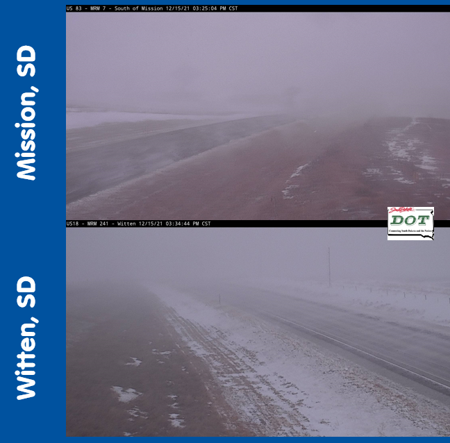 Hazardous conditions that prompted our first Snow Squall Warnings. |
Photos & Video
House has been removed from the road and traffic has resumed on Highway 44 and 161st Street, east of Farmingdale. pic.twitter.com/X6WhQZSQL6
— Pennington County SO (@PennCoSheriff) December 15, 2021
Extreme winds are reeking havoc on western South Dakota. Numerous high profile vehicles are being blown over due to the winds. A No Travel Advisory is being issued for these vehicles until the winds subside. #keepSDsafe pic.twitter.com/5YTt8ZA3qB
— South Dakota Highway Patrol (@SDHighwayPatrol) December 15, 2021
Winds are so bad in Box Elder right now that siding is actually blowing off my neighbors house. No travel advisories are in effect along parts of I-90 for high-profile vehicles, and based on recent scanner traffic, several semis have been blown over in western SD. pic.twitter.com/HfFmSoy8Cr
— Darsha Nelson (@darsha_tv) December 15, 2021
This wind is no joke. The roads aren’t great in spots either. If you don’t have to be out, I wouldn’t.
— Jim Bussell (@jbuss79) December 15, 2021
This is 161st Ave. south of New Underwood. #sdwx pic.twitter.com/wq4MH1J7IY
Snow Squall
Our first and second ever Snow Squall Warnings were issued for the band of snow that developed across south central South Dakota in the afternoon, accompanied by very strong winds.
A snow squall warning is in effect until 5:00 PM CST for US-18, US-83 near Antelope; US-18 near Carter; US-18, US-83 near Mission and US-18 near Okreek. pic.twitter.com/wCwABrxtbn
— NWS Rapid City (@NWSRapidCity) December 15, 2021
A snow squall warning is in effect until 5:45 PM CST for US-18 near Carter and US-18, US-183 near Witten. pic.twitter.com/6VqrQ1JRy7
— NWS Rapid City (@NWSRapidCity) December 15, 2021
Wind Reports
...MAXIMUM OBSERVED WINDS (AT LEAST 50 MPH) SORTED BY MAGNITUDE...

LOCATION                      MAX WIND    COMMENTS
                               MPH

3 NW WASTA SD                    79        204 PM 12/15/2021
3 NNW SCENIC SD                  78        106 PM 12/15/2021
5 WNW NEW UNDERWOOD SD           74       1249 PM 12/15/2021
RAPID CITY ARPT SD               74       1105 AM 12/15/2021
15 SSE MISSION SD                71        426 PM 12/15/2021
8 S WALL SD                      67        120 PM 12/15/2021
8 SSW FOLSOM SD                  66       1108 AM 12/15/2021
10 W EDGEMONT SD                 65        126 PM 12/15/2021
1 WNW CAPUTA SD                  65       1045 AM 12/15/2021
ELLSWORTH AFB SD                 64        930 AM 12/15/2021
1 NE MIDLAND SD                  64       1243 PM 12/15/2021
3 E PHILIP SD                    63        129 PM 12/15/2021
1 WSW RED ELM SD                 62        329 PM 12/15/2021
1 NE WINNER SD                   62        340 PM 12/15/2021
11 SW PARMELEE SD                62        504 PM 12/15/2021
6 W PARMELEE SD                  61        128 PM 12/15/2021
3 W UNION CENTER SD              61        257 PM 12/15/2021
4 SSE WITTEN SD                  60        621 PM 12/15/2021
7 ESE ROSEBUD SD                 60        505 PM 12/15/2021
7 NNE RALPH SD                   60        219 PM 12/15/2021
9 ENE BELVIDERE SD               60        614 PM 12/15/2021
WEWELA SD                        59        325 PM 12/15/2021
4 E CACTUS FLAT SD               59       1159 AM 12/15/2021
25 ESE WRIGHT WY                 58        105 PM 12/15/2021
1 ENE MUD BUTTE SD               58       1237 PM 12/15/2021
2 E COTTONWOOD SD                58       1240 PM 12/15/2021
1 NNE FAITH SD                   58        532 PM 12/15/2021
1 E DWTN RAPID CITY SD           58        317 PM 12/15/2021
WASTA SD                         58       1055 AM 12/15/2021
7 E STURGIS SD                   57       1220 PM 12/15/2021
7 E WANBLEE SD                   56        521 PM 12/15/2021
1 N BUFFALO SD                   56        133 PM 12/15/2021
UNION CENTER SD                  56        230 PM 12/15/2021
12 WSW CASTLE ROCK SD            55        258 PM 12/15/2021
9 SW BATESLAND SD                55        406 PM 12/15/2021
13 SSW REVA SD                   54        338 PM 12/15/2021
1 NE ECHETA WY                   53        851 AM 12/15/2021
6 WNW NEWCASTLE WY               52       1035 AM 12/15/2021
14 NNW EDGEMONT SD               52        120 PM 12/15/2021
7 SSE MEADOW SD                  52        403 PM 12/15/2021
8 N REDIG SD                     52        948 AM 12/15/2021
6 W ROCHFORD SD                  51        208 PM 12/15/2021
3 W LEMMON SD                    51        448 PM 12/15/2021
 |
Media use of NWS Web News Stories is encouraged! Please acknowledge the NWS as the source of any news information accessed from this site. |
|

