
Tropical Depression Two is expected to gradually strengthen and could bring tropical storm conditions to the Florida Panhandle beginning late Monday. Areas of flash flooding will be possible through Thursday along the eastern and central Gulf Coast. Severe thunderstorms will develop and move along a cold front crossing the Upper Midwest Monday, and through the Ohio Valley/Mid-Atlantic on Tuesday. Read More >
Overview
|
On November 11, 2021, an intense low pressure system brought a cold front through the region, which resulted in very strong winds across our area. Numerous wind gusts over 60 mph were reported, with the strongest wind gust near Midland at 1132 AM of 82 mph! Several semi trucks were overturned. The winds gradually decreased overnight, but remained breezy into the next day. |
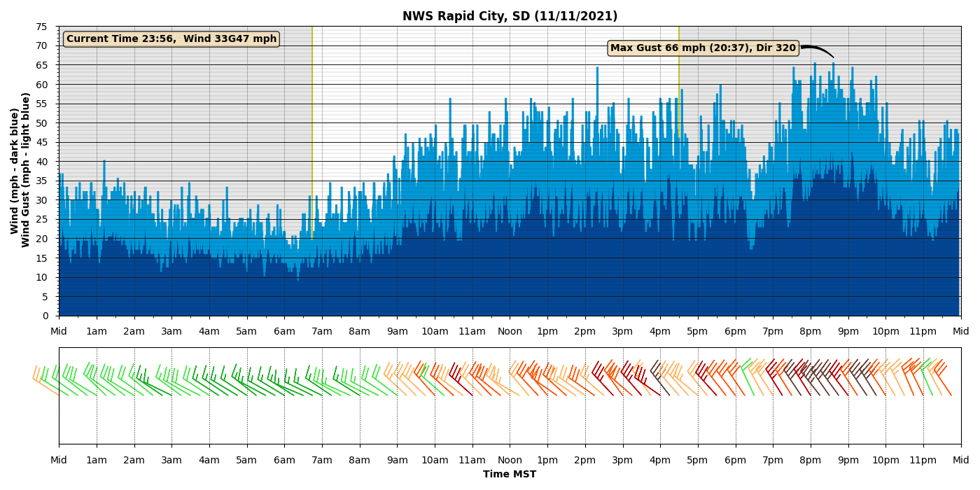 Wind observations from NWS Rapid City office |
Wind Reports:
Public Information Statement
National Weather Service Rapid City SD
1010 PM MST Thu Nov 11 2021

The following are unofficial observations taken during the past 21
hours

...MAXIMUM OBSERVED WINDS SORTED BY MAGNITUDE...

LOCATION                      MAX WIND    COMMENTS
                               MPH

1 NE Midland SD                  82       1132 AM 11/11/2021
9 ENE Belvidere SD               78       1038 AM 11/11/2021
4 E Cactus Flat SD               78       1253 PM 11/11/2021
1 N Buffalo SD                   78       1240 PM 11/11/2021
15 SSE Mission SD                76        134 PM 11/11/2021
11 SW Parmelee SD                76       1233 PM 11/11/2021
3 NW Wasta SD                    75        109 PM 11/11/2021
7 E Wanblee SD                   74        104 PM 11/11/2021
1 ENE Mud Butte SD               71       1107 AM 11/11/2021
3 E Philip SD                    71       1252 PM 11/11/2021
1 NE Winner SD                   70       1151 AM 11/11/2021
6 W Parmelee SD                  70        128 PM 11/11/2021
8 S Wall SD                      70        220 PM 11/11/2021
3 W Union Center SD              70       1236 PM 11/11/2021
4 SSE Witten SD                  69       1039 AM 11/11/2021
5 WNW New Underwood SD           68        410 PM 11/11/2021
Rapid City Arpt SD               68        719 PM 11/11/2021
13 SSW Reva SD                   67       1107 AM 11/11/2021
12 WSW Castle Rock SD            67       1207 PM 11/11/2021
Wewela SD                        67       1109 AM 11/11/2021
1 E Dwtn Rapid City SD           66        837 PM 11/11/2021
1 NNE Faith SD                   66        924 AM 11/11/2021
3 NNW Scenic SD                  66        122 PM 11/11/2021
7 ESE Rosebud SD                 66       1210 PM 11/11/2021
7 S Shadehill SD                 65        808 AM 11/11/2021
7 NNE Ralph SD                   65        209 PM 11/11/2021
2 SW Bridger SD                  65       1219 PM 11/11/2021
8 N Redig SD                     65       1228 PM 11/11/2021
7 WSW Hoover SD                  64        134 PM 11/11/2021
1 WSW Red Elm SD                 63        815 PM 11/11/2021
4 S Dwtn Rapid City SD           62        810 PM 11/11/2021
1 W Box Elder SD                 62        417 PM 11/11/2021
Wasta SD                         62       1115 AM 11/11/2021
7 SSE Meadow SD                  61        902 AM 11/11/2021
Ellsworth AFB SD                 61        330 PM 11/11/2021
4 N Ludlow SD                    61        738 AM 11/11/2021
3 W Lemmon SD                    59       1202 PM 11/11/2021
Pringle SD                       58        955 PM 11/11/2021
2 E Cottonwood SD                58        145 PM 11/11/2021
7 E Sturgis SD                   58        315 PM 11/11/2021
4 E Dwtn Spearfish SD            58       1255 PM 11/11/2021
2 NNW Pactola Res SD             55        339 PM 11/11/2021
6 WSW Opal SD                    55        216 PM 11/11/2021
Four Corners WY                  55        242 PM 11/11/2021
13 NW Belle Fourche SD           54        219 PM 11/11/2021
8 SSW Folsom SD                  54        328 PM 11/11/2021
3 WSW Fairburn SD                54        808 PM 11/11/2021
2 SSW Custer SD                  54        558 PM 11/11/2021
8 WNW Fairburn SD                53        918 PM 11/11/2021
1 ESE Martin SD                  53        415 PM 11/11/2021
10 W Edgemont SD                 53        246 PM 11/11/2021
1 E Lead SD                      53        830 PM 11/11/2021
2 W Hamill SD                    52        345 PM 11/11/2021
1 NNW Nisland SD                 51        205 PM 11/11/2021
8 W Jewel Cave SD                51        253 PM 11/11/2021
6 W Rochford SD                  50        808 PM 11/11/2021
Photos
It’s windy out there! âš ï¸ðŸ’¨âš ï¸
— South Dakota Highway Patrol (@SDHighwayPatrol) November 11, 2021
We’ve seen over 10 semi‘s tipped over on South Dakota roadways today.
Be advised: 👇
High wind warnings are in effect for all of South Dakota through Friday, creating hazardous driving for trucks and other high profile vehicles. pic.twitter.com/ExVJokFAFu
High winds have caused major damage over the last 24 hours. We are glad to report that there have been no fatalities connected to the weather! Stay alert and help #KeepSDsafe.
— SDPublicSafety (@SDPublicSafety) November 12, 2021
✅Buckle up
✅Slow down
✅ Stay alert pic.twitter.com/p7uC3jUFOf
 |
Media use of NWS Web News Stories is encouraged! Please acknowledge the NWS as the source of any news information accessed from this site. |
|

