
Tropical Depression Two is expected to gradually strengthen and could bring tropical storm conditions to the Florida Panhandle beginning late Monday. Areas of flash flooding will be possible through Thursday along the eastern and central Gulf Coast. Severe thunderstorms will develop and move along a cold front crossing the Upper Midwest Monday, and through the Ohio Valley/Mid-Atlantic on Tuesday. Read More >
Overview
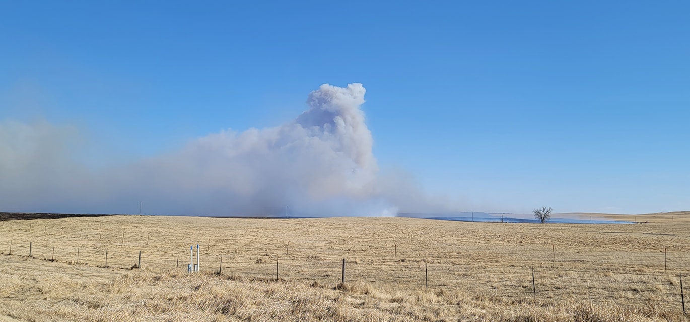
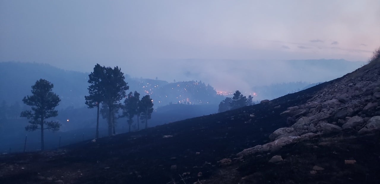
| A strong low pressure system moved across the Northern Plains on Monday, March 29th, 2021, and brought a period of very strong winds to the region. Strong west to southwest winds developed Sunday night, then shifted to the northwest on Monday as a vigorous cold front swept through. The strongest wind gust of 81 mph was measured Monday morning on the south side of Rapid City. In addition, very dry air combined with the strong winds and dry vegetation led to multiple fires in the Black Hills and prairies, with the Schroeder Fire infringing on the western edge of Rapid City and the Divide Fire in Perkins County. The image to the right shows the wind observations at the NWS office near downtown Rapid City for March 29th. |
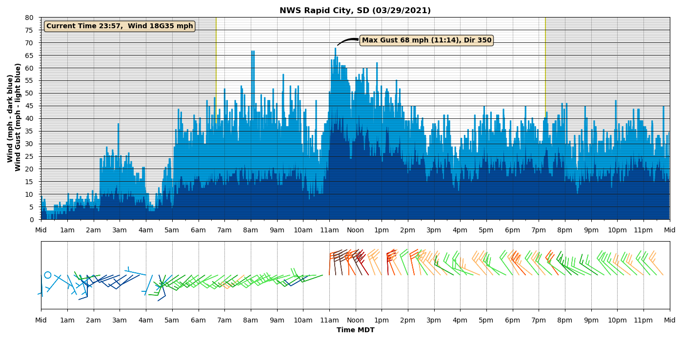 |
| NWS Rapid City Wind Observations |
Photos
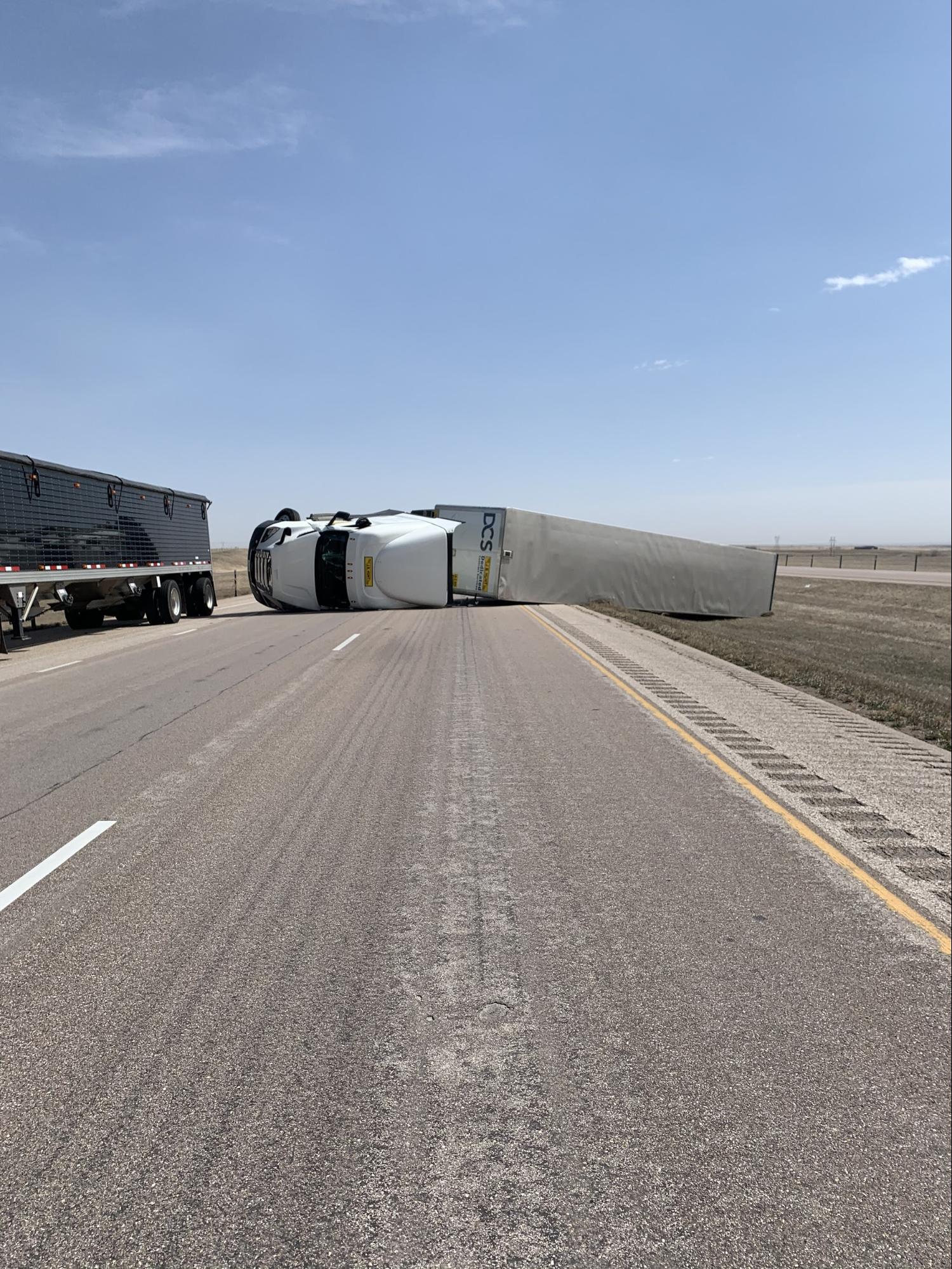 |
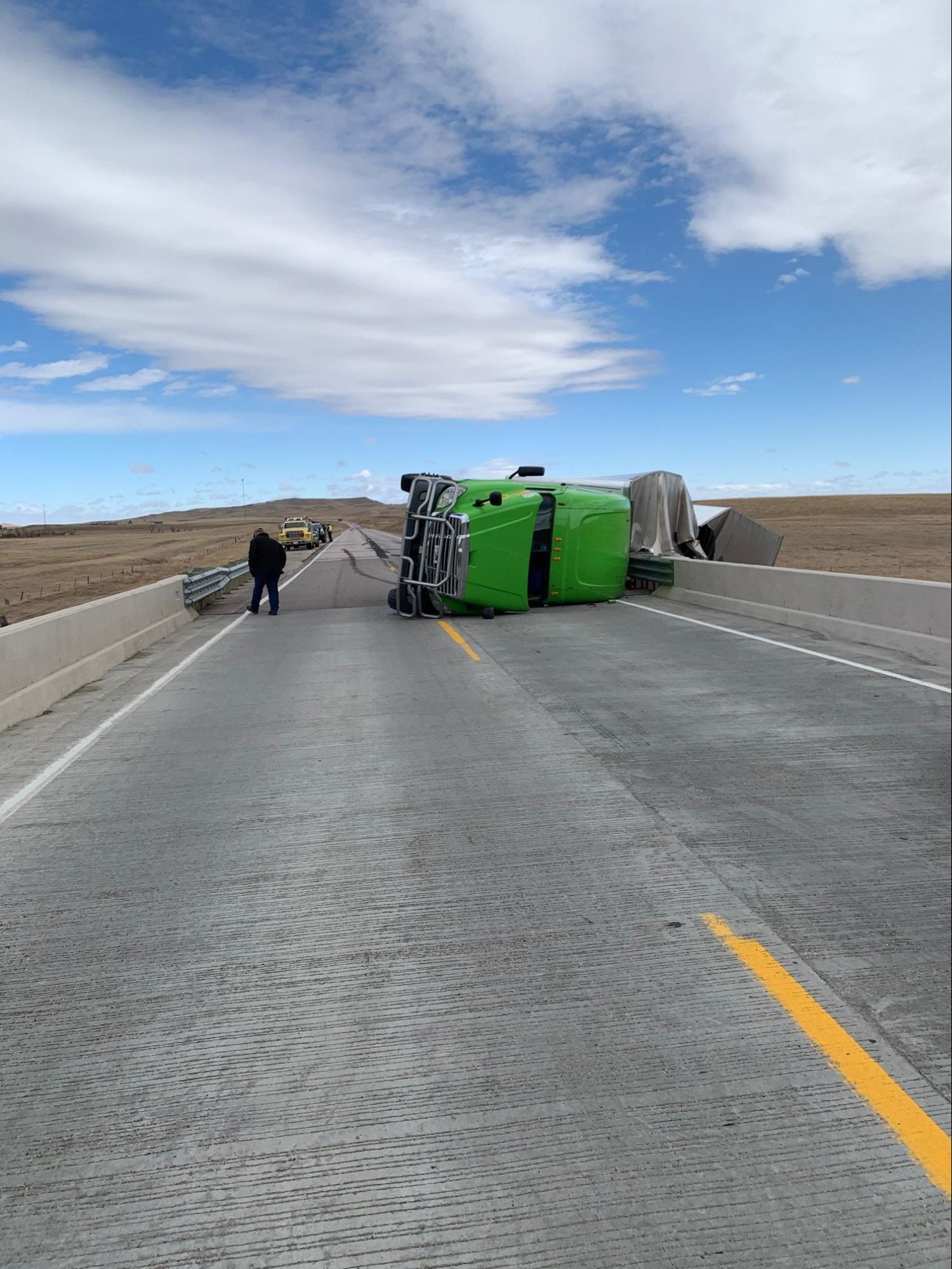 |
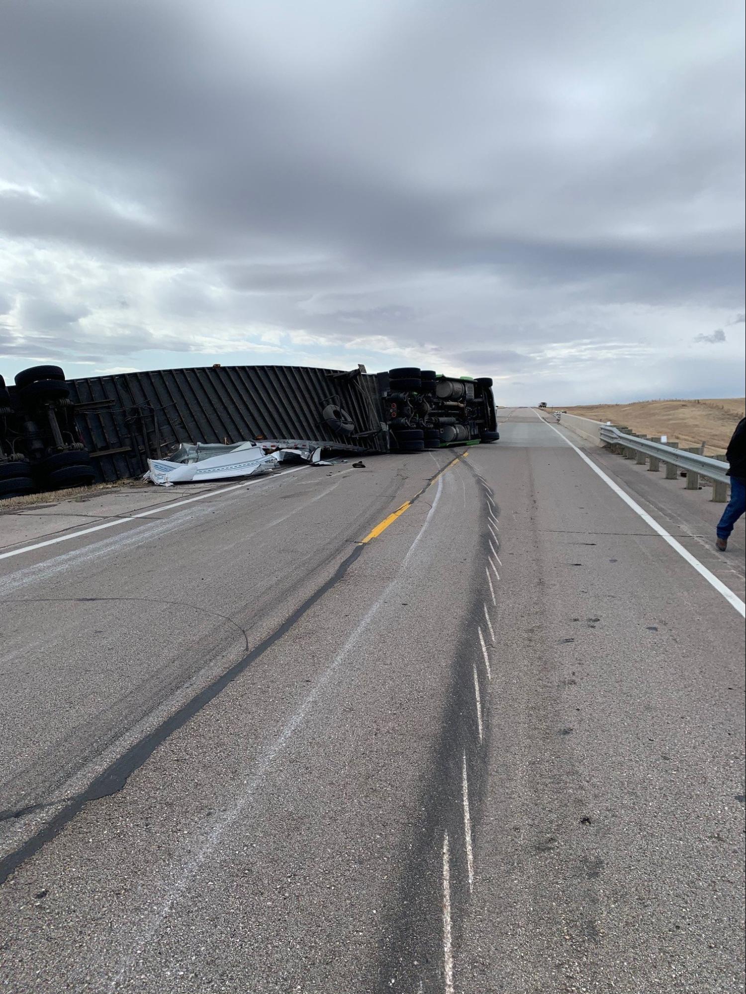 |
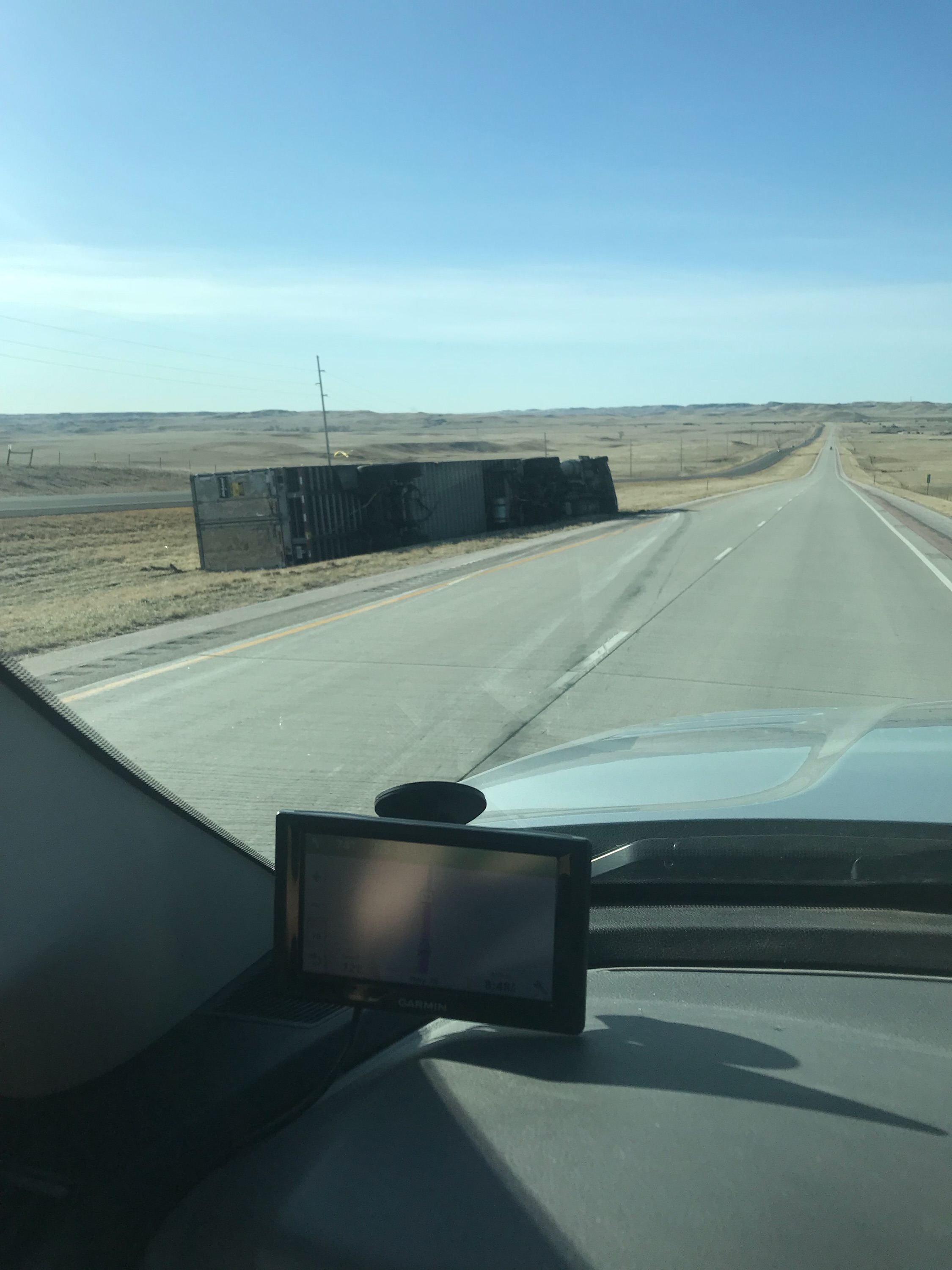 |
| I-90 near New Underwood (SD Highway Patrol) |
US 85 near Ludlow (SD Highway Patrol) |
US 85 near Ludlow (SD Highway Patrol) |
US 79 near Hermosa (J. King) |
 |
 |
 |
| Divide Fire near Bison (Bison Fire Dept) |
Schroeder Fire (Schroeder Fire Facebook Page) |
Schroeder Fire Satellite Image (Sentinel-2) |
Storm Reports
Public Information Statement
National Weather Service Rapid City SD
543 PM MDT Mon Mar 29 2021

...Highest winds in the past 18 hours

***********************PEAK WIND GUST***********************

LOCATION             MAX WIND      TIME/DATE  COMMENTS
                         GUST       MEASURED
                        (mph)

SOUTH DAKOTA

...Bennett County...
  1 ESE Martin             59  1035 AM  3/29  AWOS

...Butte County...
  12 WSW Castle Rock       77   934 AM  3/29  SDDOT
  13 NW Belle Fourche      66  1009 AM  3/29  SDDOT
  1 NNW Nisland            60   955 AM  3/29  SDSU
  1 SW Newell              53  1015 AM  3/29  CWOP

...Custer County...
  3 WSW Fairburn           64  1054 AM  3/29  SDDOT
  8 W Jewel Cave           62  1029 AM  3/29  SDDOT
  8 WNW Fairburn           60  1118 AM  3/29  RAWS
  2 SSW Custer             56  1034 AM  3/29  ASOS
  Pringle                  54  1034 AM  3/29  SDDOT

...Fall River County...
  10 W Edgemont            75  1029 AM  3/29  SDDOT
  12 E Oelrichs            71  1208 PM  3/29  SDDOT
  4 NNE Angostura Res      59  1136 AM  3/29  AWOS

...Haakon County...
  1 NE Midland             72  1218 PM  3/29  SDDOT
  3 E Philip               64   143 PM  3/29  ASOS

...Harding County...
  1 N Buffalo              74  1008 AM  3/29  ASOS
  7 NNE Ralph              70   203 PM  3/29  SDDOT
  8 N Redig                70   353 PM  3/29  SDDOT
  4 N Ludlow               70  1034 AM  3/29  SDDOT
  13 SSW Reva              64  1152 AM  3/29  SDDOT
  10 W Reva                54  1040 AM  3/29  SDSU

...Jackson County...
  7 E Wanblee              67  1139 AM  3/29  SDDOT
  9 ENE Belvidere          65  1223 PM  3/29  SDDOT
  4 E Cactus Flat          63  1213 PM  3/29  SDDOT
  2 E Cottonwood           50  1055 AM  3/29  SDSU

...Lawrence County...
  3 SE Dwtn Spearfish      62   511 AM  3/29  RAWS
  4 N Silver City          60   810 AM  3/29  SDDOT
  1 E Lead                 60   420 AM  3/29  CWOP
  4 E Dwtn Spearfish       56  1035 AM  3/29  AWOS
  2 ESE Dwtn Spearfish     54   431 AM  3/29  CWOP

...Meade County...
  1 ENE Mud Butte          74   436 PM  3/29  SDDOT
  7 NNE Ellsworth AFB      72  1042 AM  3/29  NWS Employee
  1 NNE Faith              70  1029 AM  3/29  ASOS
  3 W Union Center         68   204 PM  3/29  SDDOT
  Ellsworth AFB            66  1213 PM  3/29  Other Federal
  7 E Sturgis              58   215 PM  3/29  AWOS
  6 WSW Opal               55  1015 AM  3/29  CWOP

...Oglala Lakota County...
  3 ESE Pine Ridge         70  1213 PM  3/29  ASOS
  5 NE Porcupine           67  1241 PM  3/29  RAWS
  9 SW Batesland           63  1220 PM  3/29  SDDOT

...Pennington County...
  4 S Dwtn Rapid City      81   704 AM  3/29  NWS Employee
  9 ENE Hayward            76   705 AM  3/29  Mesonet
  Rapid City Arpt          75   152 PM  3/29  ASOS
  3 NW Wasta               75  1109 AM  3/29  SDDOT
  3 NNW Scenic             72  1223 PM  3/29  SDDOT
  5 WNW New Underwood      71   139 PM  3/29  SDDOT
  1 E Dwtn Rapid City      68  1114 AM  3/29  Official NWS Obs
  1 W Box Elder            68   139 PM  3/29  SDDOT
  2 NNW Pactola Res        60   444 PM  3/29  SDDOT
  8 S Wall                 59   320 PM  3/29  RAWS
  Mount Rushmore           54   713 AM  3/29  RAWS

...Perkins County...
  3 W Lemmon               67  1139 AM  3/29  SDDOT
  7 SSE Meadow             66  1124 AM  3/29  SDDOT
  7 S Shadehill            63  1208 PM  3/29  RAWS
  3 ESE Lemmon             56  1125 AM  3/29  SDSU
  Bison                    53   435 PM  3/29  SDSU

...Todd County...
  11 SW Parmelee           69  1119 AM  3/29  SDDOT
  6 W Parmelee             59  1228 PM  3/29  RAWS
  15 SSE Mission           58  1235 PM  3/29  SDDOT
  7 ESE Rosebud            55  1120 AM  3/29  SDSU

...Tripp County...
  1 NE Winner              58   240 PM  3/29  ASOS
  4 SSE Witten             58   203 PM  3/29  SDDOT
  Wewela                   51   309 PM  3/29  SDDOT
  2 W Hamill               50  1245 PM  3/29  SDSU

...Ziebach County...
  1 WSW Red Elm            74  1039 AM  3/29  SDDOT
  2 SW Bridger             60   114 PM  3/29  SDDOT

WYOMING

...Campbell County...
  5 NNW Dwtn Gillette      71   912 AM  3/29  ASOS
  25 ESE Wright            68  1005 AM  3/29  RAWS
  1 NE Echeta              68   951 AM  3/29  RAWS
  10 SW Dwtn Gillette      59  1240 AM  3/29  Public
  7 NW Rockypoint          56   833 AM  3/29  CWOP
  13 NNE Wright            53   942 AM  3/29  WYDOT
  Wright                   53   945 AM  3/29  Mesonet
  16 WSW Dwtn Gillette     50   906 AM  3/29  WYDOT

...Crook County...
  Pine Haven               54  1029 AM  3/29  CWOP
  10 ESE Pine Haven        53   946 AM  3/29  WYDOT
  Beulah                   52   956 AM  3/29  WYDOT

...Weston County...
  6 WNW Newcastle          54   115 PM  3/29  AWOS
  Four Corners             53  1252 PM  3/29  WYDOT


***********************SUSTAINED WIND***********************

LOCATION                 WIND      TIME/DATE  COMMENTS
                        SPEED       MEASURED
                        (mph)

SOUTH DAKOTA

...Butte County...
  12 WSW Castle Rock       56  1019 AM  3/29  SDDOT
  13 NW Belle Fourche      50  1054 AM  3/29  SDDOT

...Custer County...
  3 WSW Fairburn           45  1054 AM  3/29  SDDOT
  8 W Jewel Cave           41  1029 AM  3/29  SDDOT

...Fall River County...
  10 W Edgemont            57  1029 AM  3/29  SDDOT
  12 E Oelrichs            53  1208 PM  3/29  SDDOT

...Haakon County...
  1 NE Midland             54   124 PM  3/29  SDDOT
  3 E Philip               43  1203 PM  3/29  ASOS

...Harding County...
  4 N Ludlow               54   304 PM  3/29  SDDOT
  7 NNE Ralph              53  1034 AM  3/29  SDDOT
  1 N Buffalo              53   156 PM  3/29  ASOS
  8 N Redig                51   353 PM  3/29  SDDOT
  13 SSW Reva              42  1139 AM  3/29  SDDOT

...Jackson County...
  7 E Wanblee              54  1139 AM  3/29  SDDOT
  4 E Cactus Flat          49  1213 PM  3/29  SDDOT
  9 ENE Belvidere          47  1044 AM  3/29  SDDOT
  2 E Cottonwood           40  1215 PM  3/29  SDSU

...Lawrence County...
  4 E Dwtn Spearfish       45   435 AM  3/29  AWOS

...Meade County...
  1 ENE Mud Butte          51  1019 AM  3/29  SDDOT
  Ellsworth AFB            51  1222 PM  3/29  Other Federal
  3 W Union Center         50   204 PM  3/29  SDDOT
  1 NNE Faith              46  1256 PM  3/29  ASOS
  7 E Sturgis              45   215 PM  3/29  AWOS

...Oglala Lakota County...
  9 SW Batesland           48  1225 PM  3/29  SDDOT
  5 NE Porcupine           45  1041 AM  3/29  RAWS

...Pennington County...
  Rapid City Arpt          58   152 PM  3/29  ASOS
  3 NNW Scenic             56  1223 PM  3/29  SDDOT
  3 NW Wasta               56   319 PM  3/29  SDDOT
  4 S Dwtn Rapid City      52   659 AM  3/29  NWS Employee
  1 W Box Elder            51  1124 AM  3/29  SDDOT
  5 WNW New Underwood      50   139 PM  3/29  SDDOT
  1 E Dwtn Rapid City      47  1114 AM  3/29  Official NWS Obs
  8 S Wall                 46   120 PM  3/29  RAWS

...Perkins County...
  3 W Lemmon               48  1139 AM  3/29  SDDOT
  7 SSE Meadow             46  1119 AM  3/29  SDDOT
  3 ESE Lemmon             42  1125 AM  3/29  SDSU
  Bison                    41  1115 AM  3/29  AWOS
  7 S Shadehill            40  1108 AM  3/29  RAWS

...Todd County...
  11 SW Parmelee           49  1119 AM  3/29  SDDOT
  6 W Parmelee             45  1128 AM  3/29  RAWS
  15 SSE Mission           44  1235 PM  3/29  SDDOT
  7 ESE Rosebud            43  1205 PM  3/29  SDSU

...Tripp County...
  1 NE Winner              41   219 PM  3/29  ASOS
  4 SSE Witten             41   233 PM  3/29  SDDOT

...Ziebach County...
  1 WSW Red Elm            52   223 PM  3/29  SDDOT

WYOMING

...Campbell County...
  25 ESE Wright            49  1005 AM  3/29  RAWS
  5 NNW Dwtn Gillette      48   920 AM  3/29  ASOS
  7 NW Rockypoint          45   329 PM  3/29  CWOP
  13 NNE Wright            43   922 AM  3/29  WYDOT

...Crook County...
  10 ESE Pine Haven        42   946 AM  3/29  WYDOT

...Weston County...
  6 WNW Newcastle          40   115 PM  3/29  AWOS
  Four Corners             40   106 PM  3/29  WYDOT


...MAXIMUM OBSERVED WINDS SORTED BY MAGNITUDE...

LOCATION                      MAX WIND    COMMENTS
                               MPH

4 S Dwtn Rapid City SD           81        704 AM 3/29/2021
12 WSW Castle Rock SD            77        934 AM 3/29/2021
9 ENE Hayward SD                 76        705 AM 3/29/2021
10 W Edgemont SD                 75       1029 AM 3/29/2021
Rapid City Arpt SD               75        152 PM 3/29/2021
3 NW Wasta SD                    75       1109 AM 3/29/2021
1 WSW Red Elm SD                 74       1039 AM 3/29/2021
1 ENE Mud Butte SD               74        436 PM 3/29/2021
1 N Buffalo SD                   74       1008 AM 3/29/2021
1 NE Midland SD                  72       1218 PM 3/29/2021
3 NNW Scenic SD                  72       1223 PM 3/29/2021
7 NNE Ellsworth AFB SD           72       1042 AM 3/29/2021
5 WNW New Underwood SD           71        139 PM 3/29/2021
12 E Oelrichs SD                 71       1208 PM 3/29/2021
5 NNW Dwtn Gillette WY           71        912 AM 3/29/2021
3 ESE Pine Ridge SD              70       1213 PM 3/29/2021
7 NNE Ralph SD                   70        203 PM 3/29/2021
1 NNE Faith SD                   70       1029 AM 3/29/2021
8 N Redig SD                     70        353 PM 3/29/2021
4 N Ludlow SD                    70       1034 AM 3/29/2021
11 SW Parmelee SD                69       1119 AM 3/29/2021
25 ESE Wright WY                 68       1005 AM 3/29/2021
1 E Dwtn Rapid City SD           68       1114 AM 3/29/2021
1 NE Echeta WY                   68        951 AM 3/29/2021
1 W Box Elder SD                 68        139 PM 3/29/2021
3 W Union Center SD              68        204 PM 3/29/2021
5 NE Porcupine SD                67       1241 PM 3/29/2021
3 W Lemmon SD                    67       1139 AM 3/29/2021
7 E Wanblee SD                   67       1139 AM 3/29/2021
13 NW Belle Fourche SD           66       1009 AM 3/29/2021
7 SSE Meadow SD                  66       1124 AM 3/29/2021
Ellsworth AFB SD                 66       1213 PM 3/29/2021
9 ENE Belvidere SD               65       1223 PM 3/29/2021
13 SSW Reva SD                   64       1152 AM 3/29/2021
3 WSW Fairburn SD                64       1054 AM 3/29/2021
3 E Philip SD                    64        143 PM 3/29/2021
7 S Shadehill SD                 63       1208 PM 3/29/2021
9 SW Batesland SD                63       1220 PM 3/29/2021
4 E Cactus Flat SD               63       1213 PM 3/29/2021
3 SE Dwtn Spearfish SD           62        511 AM 3/29/2021
8 W Jewel Cave SD                62       1029 AM 3/29/2021
8 WNW Fairburn SD                60       1118 AM 3/29/2021
2 NNW Pactola Res SD             60        444 PM 3/29/2021
2 SW Bridger SD                  60        114 PM 3/29/2021
4 N Silver City SD               60        810 AM 3/29/2021
1 NNW Nisland SD                 60        955 AM 3/29/2021
1 E Lead SD                      60        420 AM 3/29/2021
10 SW Dwtn Gillette WY           59       1240 AM 3/29/2021
6 W Parmelee SD                  59       1228 PM 3/29/2021
1 ESE Martin SD                  59       1035 AM 3/29/2021
4 NNE Angostura Res SD           59       1136 AM 3/29/2021
8 S Wall SD                      59        320 PM 3/29/2021
1 NE Winner SD                   58        240 PM 3/29/2021
15 SSE Mission SD                58       1235 PM 3/29/2021
4 SSE Witten SD                  58        203 PM 3/29/2021
7 E Sturgis SD                   58        215 PM 3/29/2021
3 ESE Lemmon SD                  56       1125 AM 3/29/2021
2 SSW Custer SD                  56       1034 AM 3/29/2021
7 NW Rockypoint WY               56        833 AM 3/29/2021
4 E Dwtn Spearfish SD            56       1035 AM 3/29/2021
6 WSW Opal SD                    55       1015 AM 3/29/2021
7 ESE Rosebud SD                 55       1120 AM 3/29/2021
10 W Reva SD                     54       1040 AM 3/29/2021
2 ESE Dwtn Spearfish SD          54        431 AM 3/29/2021
Mount Rushmore SD                54        713 AM 3/29/2021
Pringle SD                       54       1034 AM 3/29/2021
Pine Haven WY                    54       1029 AM 3/29/2021
6 WNW Newcastle WY               54        115 PM 3/29/2021
13 NNE Wright WY                 53        942 AM 3/29/2021
Wright WY                        53        945 AM 3/29/2021
Bison SD                         53        435 PM 3/29/2021
1 SW Newell SD                   53       1015 AM 3/29/2021
10 ESE Pine Haven WY             53        946 AM 3/29/2021
Four Corners WY                  53       1252 PM 3/29/2021
Beulah WY                        52        956 AM 3/29/2021
Wewela SD                        51        309 PM 3/29/2021
16 WSW Dwtn Gillette WY          50        906 AM 3/29/2021
2 E Cottonwood SD                50       1055 AM 3/29/2021
2 W Hamill SD                    50       1245 PM 3/29/2021
 |
Media use of NWS Web News Stories is encouraged! Please acknowledge the NWS as the source of any news information accessed from this site. |
|

