
Tropical Depression Two is expected to gradually strengthen and could bring tropical storm conditions to the Florida Panhandle beginning late Monday. Areas of flash flooding will be possible through Thursday along the eastern and central Gulf Coast. Severe thunderstorms will develop and move along a cold front crossing the Upper Midwest Monday, and through the Ohio Valley/Mid-Atlantic on Tuesday. Read More >
Overview
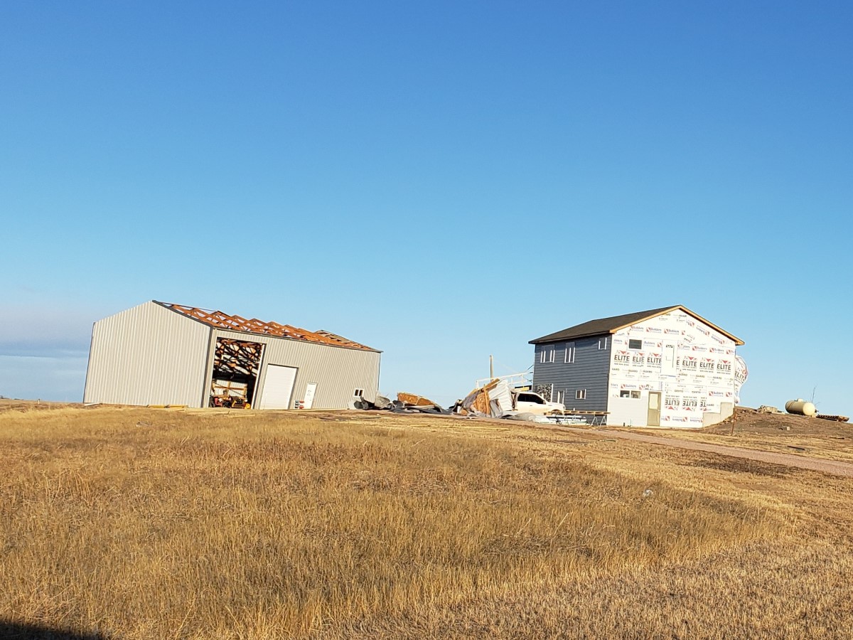
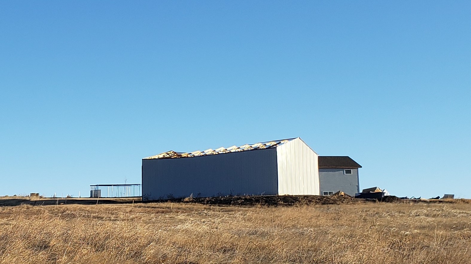
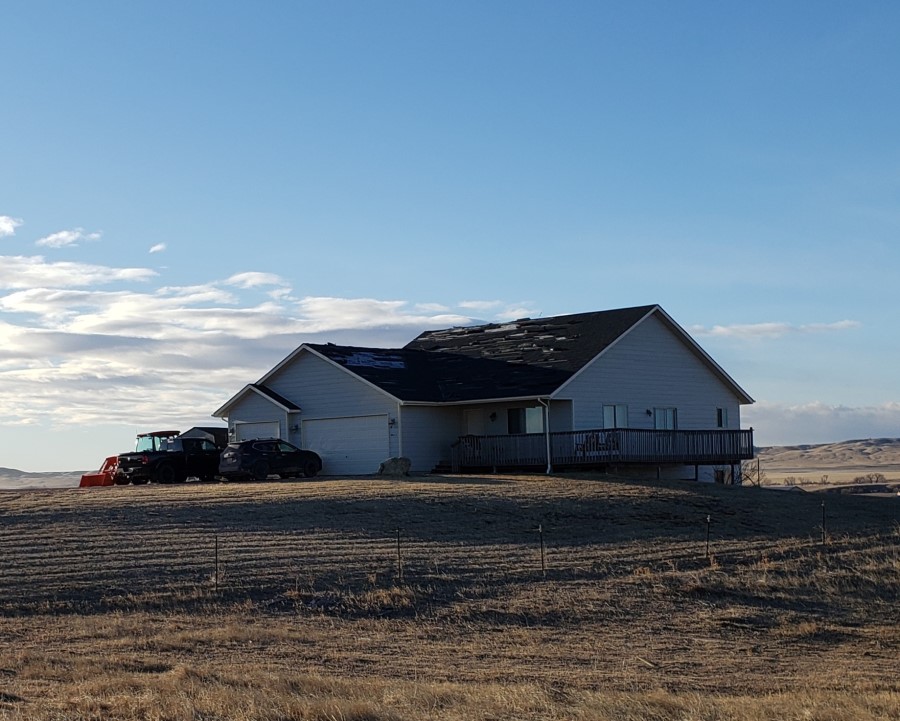
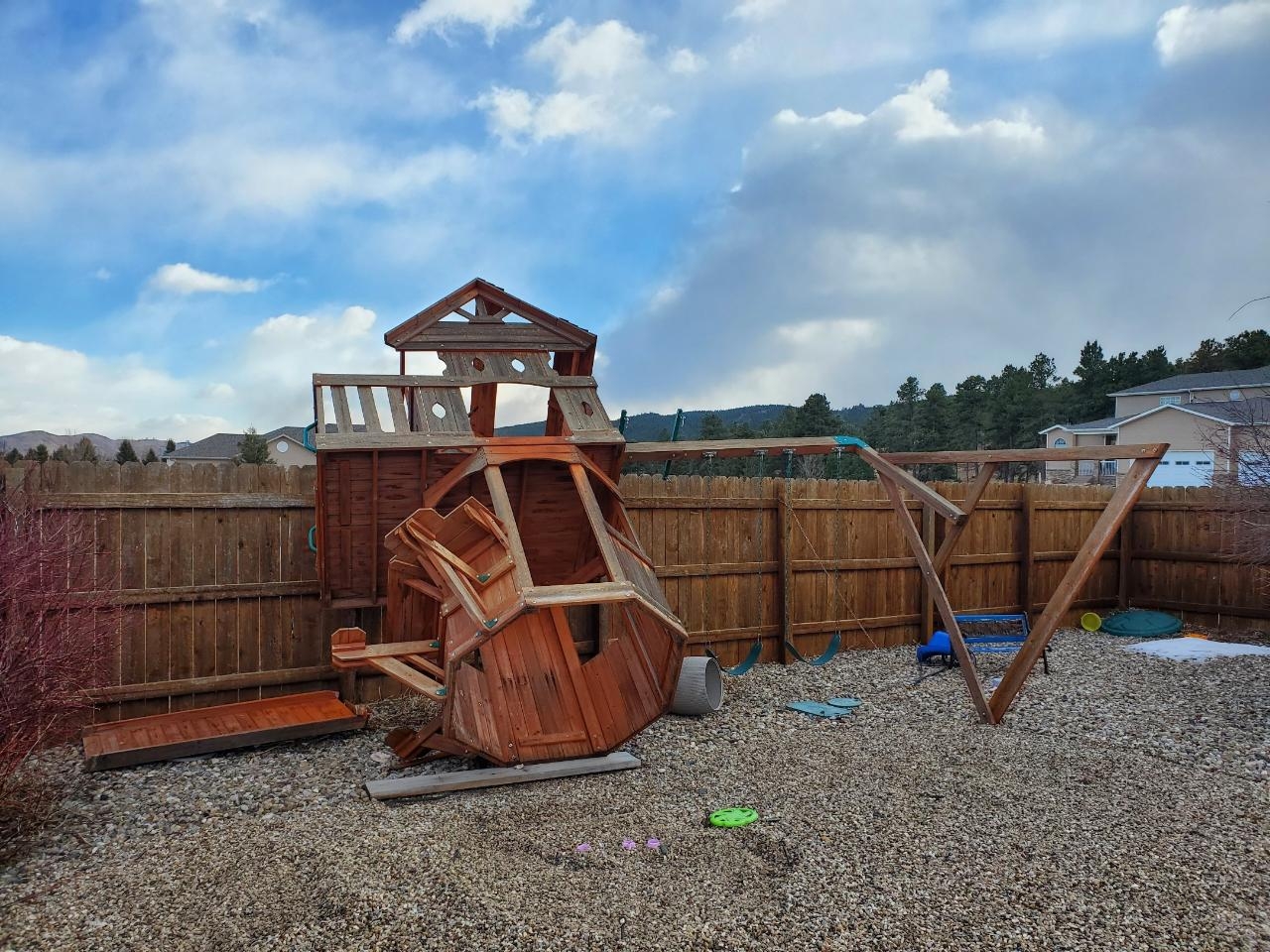
| A potent cold front swept through the region on the late afternoon and evening of Wednesday, January 13th, 2021. Behind the front, northwesterly winds became very strong. Wednesday night through Thursday night, winds across the area were sustained at 35 to 50 mph, with gusts of 60 to more than 80 mph. In Harding County, a gust of 93 mph was measured with the frontal passage! Winds finally diminished Friday morning. Numerous rollovers were reported during this long duration high wind event, especially along I-90 across western South Dakota. Many homes and businesses sustained property damage, and several wind driven grass fires produced additional damage. The image to the right shows the wind observations at the NWS office near downtown Rapid City for the duration of the high wind event. |
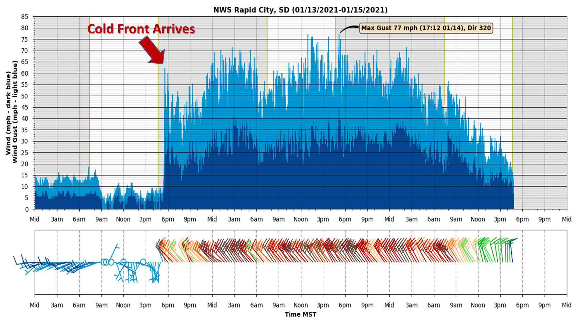 |
| NWS Rapid City Wind Observations |
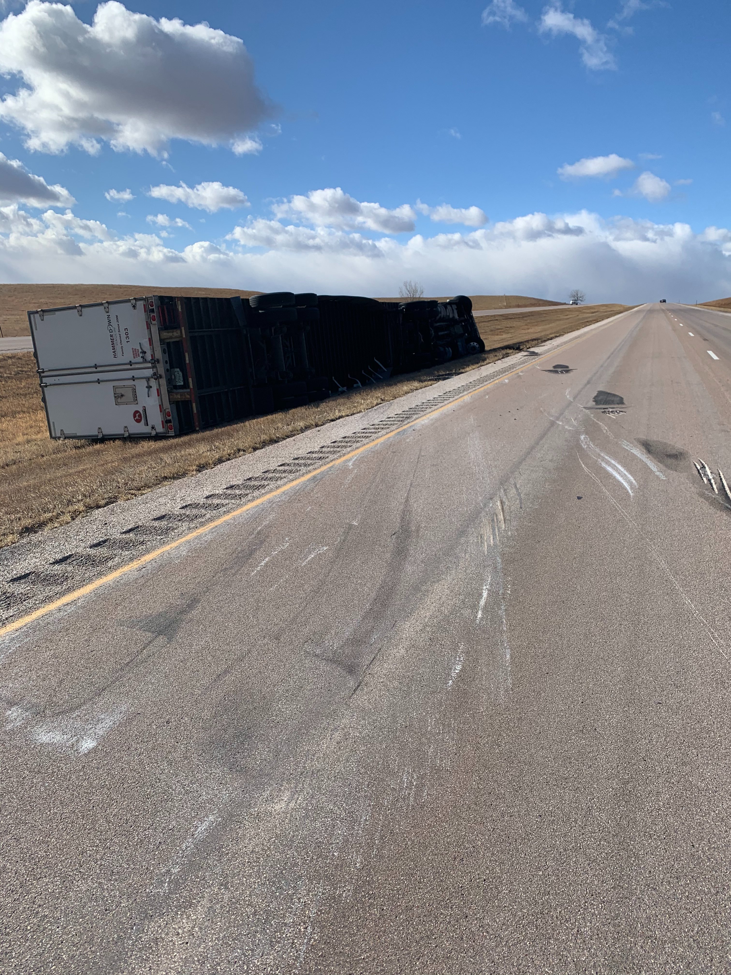
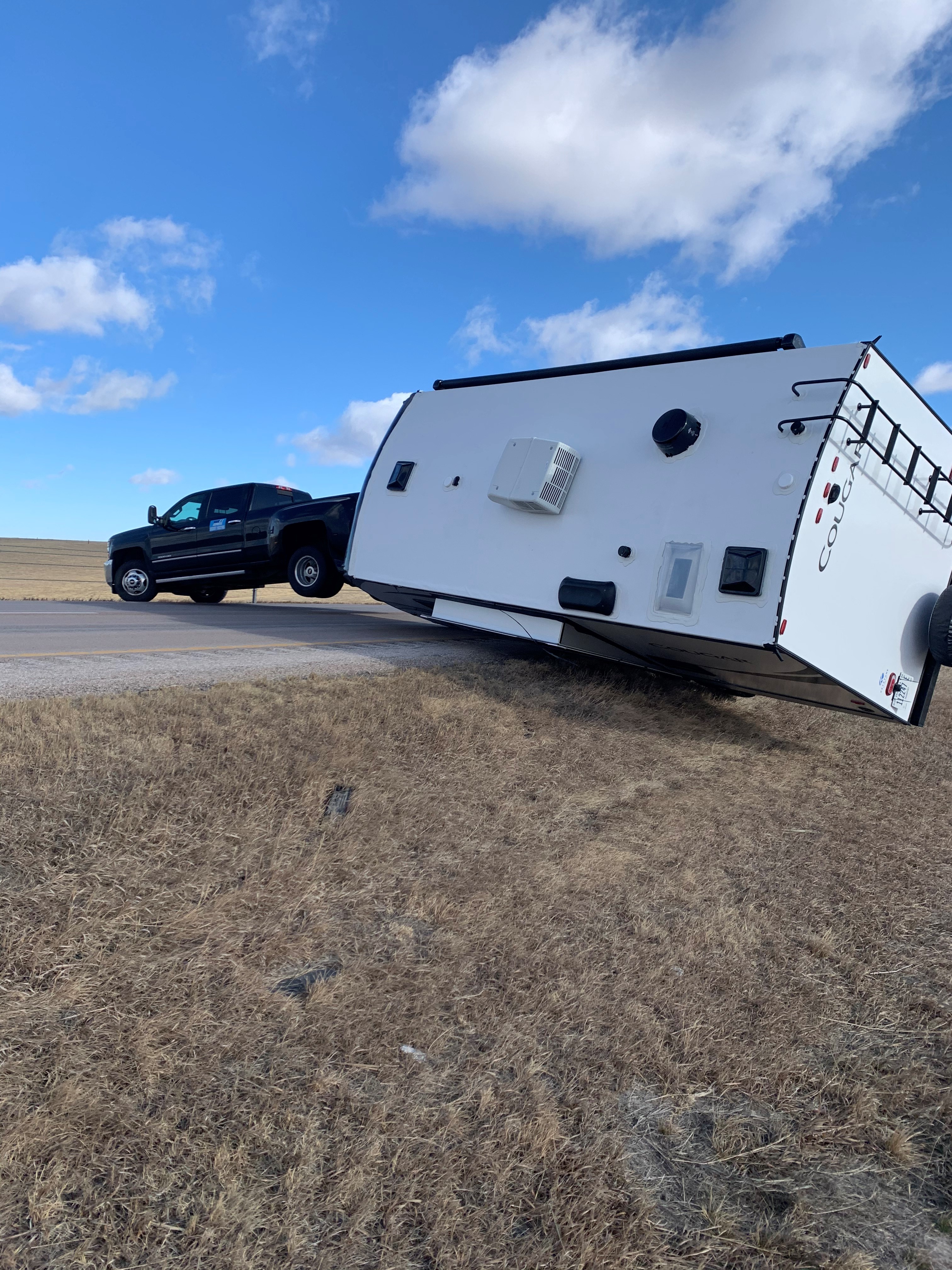
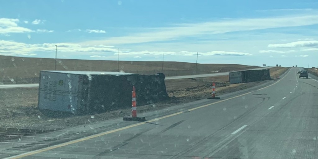
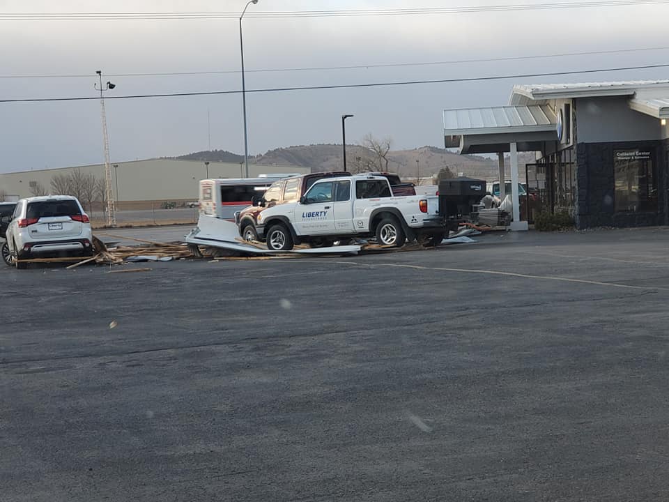
Photos
 |
 |
 |
 |
| I-90 (SD Highway Patrol) |
I-90 (SD Highway Patrol) |
I-90 (Pennington County Sheriff) |
I-90 (Pennington County Sheriff) |
 |
 |
 |
 |
| North of Box Elder (M. Smith) |
North of Box Elder (M. Smith) |
North of Box Elder (M. Smith) |
Piedmont (C. Pajorlie) |
 |
 |
| Rapid City (M. Colgan) |
Rapid City (M. Colgan) |
Storm Reports
PUBLIC INFORMATION STATEMENT
NATIONAL WEATHER SERVICE RAPID CITY SD
611 AM MST FRI JAN 15 2021

THE FOLLOWING ARE MEASURED PEAK WINDS FROM THE RECENT WIND STORM.

***********************PEAK WIND GUST***********************

LOCATION             MAX WIND      TIME/DATE  COMMENTS
                         GUST       MEASURED
                        (MPH)

SOUTH DAKOTA

...BUTTE COUNTY...
  12 WSW CASTLE ROCK       73  1239 AM  1/14  SDDOT
  13 NW BELLE FOURCHE      70   623 PM  1/13  SDDOT
  27 WNW CASTLE ROCK       65   156 AM  1/14  RAWS
  1 NNW NISLAND            57  1035 PM  1/13  SDSU
  1 SW NEWELL              54  1235 PM  1/14  CWOP

...CUSTER COUNTY...
  3 WSW FAIRBURN           69   104 AM  1/14  SDDOT
  2 SSW CUSTER             66  1152 PM  1/13  ASOS
  8 W JEWEL CAVE           62   214 PM  1/14  SDDOT
  PRINGLE                  61  1234 AM  1/14  SDDOT
  8 WNW FAIRBURN           60   118 AM  1/14  RAWS
  1 E CUSTER               58   150 AM  1/15  PUBLIC
  1 W WIND CAVE VISITO     56   813 PM  1/13  RAWS
  JEWEL CAVE               53   155 PM  1/14  RAWS

...FALL RIVER COUNTY...
  10 W EDGEMONT            71   643 PM  1/13  SDDOT
  12 E OELRICHS            58   233 PM  1/14  SDDOT
  2 SSW ORAL               50   130 PM  1/14  SDSU

...HAAKON COUNTY...
  1 NE MIDLAND             81   156 PM  1/14  SDDOT
  3 E PHILIP               74  1153 PM  1/13  ASOS

...HARDING COUNTY...
  1 N BUFFALO              93   556 PM  1/13  ASOS
  8 N REDIG                81   531 PM  1/13  SDDOT
  7 NNE RALPH              77   430 PM  1/13  SDDOT
  13 SSW REVA              75   934 AM  1/14  SDDOT
  4 N LUDLOW               68   239 PM  1/14  SDDOT
  10 W REVA                57  1145 AM  1/14  SDSU

...JACKSON COUNTY...
  4 E CACTUS FLAT          78   230 AM  1/14  SDDOT
  9 ENE BELVIDERE          71   309 PM  1/14  SDDOT
  7 E WANBLEE              70   151 PM  1/14  SDDOT
  2 E COTTONWOOD           63   225 AM  1/14  SDSU

...LAWRENCE COUNTY...
  1 E LEAD                 66   135 PM  1/14  CWOP
  4 N SILVER CITY          62   309 PM  1/14  SDDOT
  4 E DWTN SPEARFISH       58   535 AM  1/14  AWOS
  3 SE DWTN SPEARFISH      57   211 PM  1/14  RAWS
  4 NW CHEYENNE CROSSI     57   136 PM  1/14  SDDOT
  2 WSW O'NEIL PASS        53   220 AM  1/14  SDDOT

...MEADE COUNTY...
  1 ENE MUD BUTTE          82   718 PM  1/13  SDDOT
  ELLSWORTH AFB            74   101 AM  1/14  OTHER FEDERAL
  1 NNE FAITH              74   559 PM  1/14  ASOS
  1 SE STURGIS             73   216 AM  1/14  PUBLIC
  3 W UNION CENTER         69  1113 PM  1/13  SDDOT
  2 WNW STURGIS            68   102 PM  1/14  MESONET
  7 E STURGIS              64  1215 PM  1/14  SDSU
  1 NNW PIEDMONT           62   130 AM  1/14  NWS EMPLOYEE
  6 WSW OPAL               55   246 AM  1/15  CWOP

...OGLALA LAKOTA COUNTY...
  5 NE PORCUPINE           78   141 PM  1/14  RAWS
  9 SW BATESLAND           66   247 AM  1/15  SDDOT
  3 ESE PINE RIDGE         60   107 PM  1/14  ASOS

...PENNINGTON COUNTY...
  3 NNW SCENIC             82   208 PM  1/14  SDDOT
  3 NW WASTA               82   210 AM  1/14  SDDOT
  RAPID CITY ARPT          81   129 PM  1/14  ASOS
  8 S WALL                 79   220 AM  1/14  RAWS
  1 E DWTN RAPID CITY      77   512 PM  1/14  OFFICIAL NWS OBS
  5 WNW NEW UNDERWOOD      77   109 AM  1/14  SDDOT
  4 S DWTN RAPID CITY      73   249 AM  1/14  NWS EMPLOYEE
  1 W BOX ELDER            72   430 PM  1/14  SDDOT
  2 NNW PACTOLA RES        63   104 AM  1/14  SDDOT
  6 W ROCHFORD             62   608 AM  1/14  RAWS

...PERKINS COUNTY...
  7 SSE MEADOW             68  1225 PM  1/14  SDDOT
  3 W LEMMON               67   530 PM  1/14  SDDOT
  7 S SHADEHILL            64   108 PM  1/14  RAWS
  BISON                    58  1235 PM  1/14  SDSU
  3 ESE LEMMON             56  1205 PM  1/14  SDSU

...TODD COUNTY...
  15 SSE MISSION           79   309 PM  1/14  SDDOT
  11 SW PARMELEE           73   104 AM  1/14  SDDOT
  6 W PARMELEE             70   928 AM  1/14  RAWS
  7 ESE ROSEBUD            66   300 PM  1/14  SDSU

...TRIPP COUNTY...
  1 NE WINNER              74   204 PM  1/14  ASOS
  WEWELA                   71   314 PM  1/14  SDDOT
  4 SSE WITTEN             68   254 PM  1/14  SDDOT
  2 W HAMILL               56   335 PM  1/14  SDSU

...ZIEBACH COUNTY...
  2 SW BRIDGER             65   414 PM  1/14  SDDOT
  1 WSW RED ELM            58   439 AM  1/15  SDDOT

WYOMING

...CAMPBELL COUNTY...
  5 NNW DWTN GILLETTE      79   544 PM  1/13  ASOS
  1 NE ECHETA              76   451 PM  1/13  RAWS
  25 ESE WRIGHT            60  1105 AM  1/14  RAWS
  13 NNE WRIGHT            53   518 PM  1/13  WYDOT
  16 WSW DWTN GILLETTE     53   826 PM  1/13  WYDOT

...CROOK COUNTY...
  7 NW ROCKYPOINT          70   449 PM  1/13  CWOP
  BEULAH                   63  1236 AM  1/14  WYDOT
  10 ESE PINE HAVEN        60   602 PM  1/13  WYDOT
  SUNDANCE                 50  1201 AM  1/14  PUBLIC
  PINE HAVEN               50   548 PM  1/13  CWOP

...WESTON COUNTY...
  FOUR CORNERS             66   336 PM  1/14  WYDOT
  6 WNW NEWCASTLE          58   710 PM  1/13  AWOS


...MAXIMUM OBSERVED WINDS SORTED BY MAGNITUDE...

LOCATION                      MAX WIND    COMMENTS
                               MPH

1 N BUFFALO SD                   93        556 PM 1/13/2021
1 ENE MUD BUTTE SD               82        718 PM 1/13/2021
3 NNW SCENIC SD                  82        208 PM 1/14/2021
3 NW WASTA SD                    82        210 AM 1/14/2021
1 NE MIDLAND SD                  81        156 PM 1/14/2021
RAPID CITY ARPT SD               81        129 PM 1/14/2021
8 N REDIG SD                     81        531 PM 1/13/2021
15 SSE MISSION SD                79        309 PM 1/14/2021
8 S WALL SD                      79        220 AM 1/14/2021
5 NNW DWTN GILLETTE WY           79        544 PM 1/13/2021
4 E CACTUS FLAT SD               78        230 AM 1/14/2021
5 NE PORCUPINE SD                78        141 PM 1/14/2021
7 NNE RALPH SD                   77        430 PM 1/13/2021
1 E DWTN RAPID CITY SD           77        512 PM 1/14/2021
5 WNW NEW UNDERWOOD SD           77        109 AM 1/14/2021
1 NE ECHETA WY                   76        451 PM 1/13/2021
13 SSW REVA SD                   75        934 AM 1/14/2021
1 NE WINNER SD                   74        204 PM 1/14/2021
ELLSWORTH AFB SD                 74        101 AM 1/14/2021
1 NNE FAITH SD                   74        559 PM 1/14/2021
3 E PHILIP SD                    74       1153 PM 1/13/2021
4 S DWTN RAPID CITY SD           73        249 AM 1/14/2021
12 WSW CASTLE ROCK SD            73       1239 AM 1/14/2021
1 SE STURGIS SD                  73        216 AM 1/14/2021
11 SW PARMELEE SD                73        104 AM 1/14/2021
1 W BOX ELDER SD                 72        430 PM 1/14/2021
9 ENE BELVIDERE SD               71        309 PM 1/14/2021
10 W EDGEMONT SD                 71        643 PM 1/13/2021
WEWELA SD                        71        314 PM 1/14/2021
13 NW BELLE FOURCHE SD           70        623 PM 1/13/2021
6 W PARMELEE SD                  70        928 AM 1/14/2021
7 NW ROCKYPOINT WY               70        449 PM 1/13/2021
7 E WANBLEE SD                   70        151 PM 1/14/2021
3 WSW FAIRBURN SD                69        104 AM 1/14/2021
3 W UNION CENTER SD              69       1113 PM 1/13/2021
2 WNW STURGIS SD                 68        102 PM 1/14/2021
7 SSE MEADOW SD                  68       1225 PM 1/14/2021
4 SSE WITTEN SD                  68        254 PM 1/14/2021
4 N LUDLOW SD                    68        239 PM 1/14/2021
3 W LEMMON SD                    67        530 PM 1/14/2021
9 SW BATESLAND SD                66        247 AM 1/15/2021
2 SSW CUSTER SD                  66       1152 PM 1/13/2021
1 E LEAD SD                      66        135 PM 1/14/2021
FOUR CORNERS WY                  66        336 PM 1/14/2021
7 ESE ROSEBUD SD                 66        300 PM 1/14/2021
2 SW BRIDGER SD                  65        414 PM 1/14/2021
27 WNW CASTLE ROCK SD            65        156 AM 1/14/2021
7 S SHADEHILL SD                 64        108 PM 1/14/2021
7 E STURGIS SD                   64       1215 PM 1/14/2021
2 NNW PACTOLA RES SD             63        104 AM 1/14/2021
2 E COTTONWOOD SD                63        225 AM 1/14/2021
BEULAH WY                        63       1236 AM 1/14/2021
1 NNW PIEDMONT SD                62        130 AM 1/14/2021
6 W ROCHFORD SD                  62        608 AM 1/14/2021
4 N SILVER CITY SD               62        309 PM 1/14/2021
8 W JEWEL CAVE SD                62        214 PM 1/14/2021
PRINGLE SD                       61       1234 AM 1/14/2021
25 ESE WRIGHT WY                 60       1105 AM 1/14/2021
3 ESE PINE RIDGE SD              60        107 PM 1/14/2021
8 WNW FAIRBURN SD                60        118 AM 1/14/2021
10 ESE PINE HAVEN WY             60        602 PM 1/13/2021
1 WSW RED ELM SD                 58        439 AM 1/15/2021
1 E CUSTER SD                    58        150 AM 1/15/2021
BISON SD                         58       1235 PM 1/14/2021
12 E OELRICHS SD                 58        233 PM 1/14/2021
4 E DWTN SPEARFISH SD            58        535 AM 1/14/2021
6 WNW NEWCASTLE WY               58        710 PM 1/13/2021
10 W REVA SD                     57       1145 AM 1/14/2021
3 SE DWTN SPEARFISH SD           57        211 PM 1/14/2021
4 NW CHEYENNE CROSSING SD        57        136 PM 1/14/2021
1 NNW NISLAND SD                 57       1035 PM 1/13/2021
3 ESE LEMMON SD                  56       1205 PM 1/14/2021
1 W WIND CAVE VISITORS CENTER    56        813 PM 1/13/2021
2 W HAMILL SD                    56        335 PM 1/14/2021
6 WSW OPAL SD                    55        246 AM 1/15/2021
1 SW NEWELL SD                   54       1235 PM 1/14/2021
13 NNE WRIGHT WY                 53        518 PM 1/13/2021
16 WSW DWTN GILLETTE WY          53        826 PM 1/13/2021
2 WSW O'NEIL PASS SD             53        220 AM 1/14/2021
JEWEL CAVE SD                    53        155 PM 1/14/2021
2 SSW ORAL SD                    50        130 PM 1/14/2021
SUNDANCE WY                      50       1201 AM 1/14/2021
PINE HAVEN WY                    50        548 PM 1/13/2021
 |
Media use of NWS Web News Stories is encouraged! Please acknowledge the NWS as the source of any news information accessed from this site. |
|

