
Tropical Depression Two is expected to gradually strengthen and could bring tropical storm conditions to the Florida Panhandle beginning late Monday. Areas of flash flooding will be possible through Thursday along the eastern and central Gulf Coast. Severe thunderstorms will develop and move along a cold front crossing the Upper Midwest Monday, and through the Ohio Valley/Mid-Atlantic on Tuesday. Read More >
Overview
|
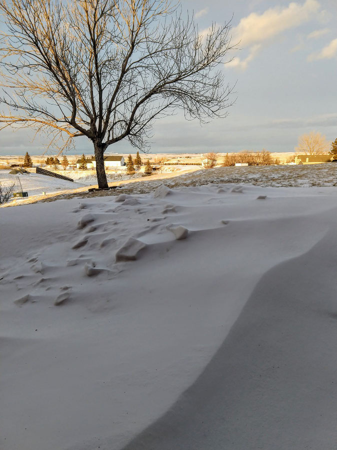
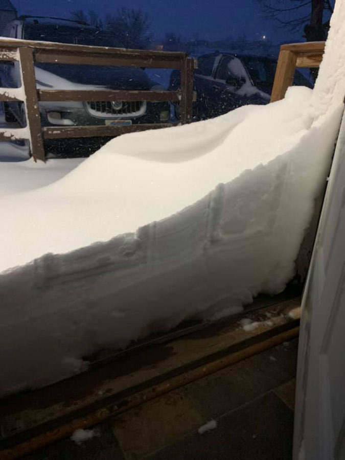
On February 24th through 25th, 2020, an elongated area of low pressure moved slowly from eastern Montana through South Dakota. Significant moisture was ingested into the system, resulting in moderate to heavy snow across northeastern Wyoming into western South Dakota. Upslope-enhanced snow developed over the northern and northeastern Black Hills and foothills, where up to 31" of snow fell over two days. Several inches of snow fell on the surrounding plains. Thankfully, strong winds weren't much of an issue with this storm, although some breezy northerly winds created some patchy blowing snow and reduced visibility at times. |
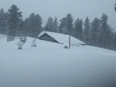
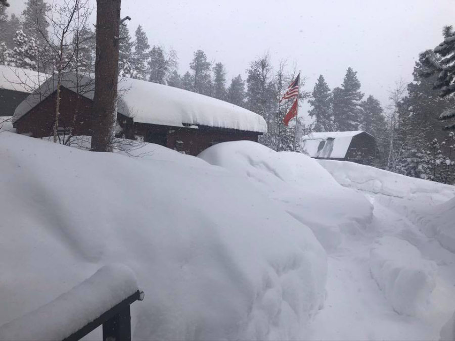 Deer Mountain Courtesy Cathy E. |
Snow
Storm total snowfall from February 24-25, 2020. The snowfall map is preliminary and may change as all information becomes available.
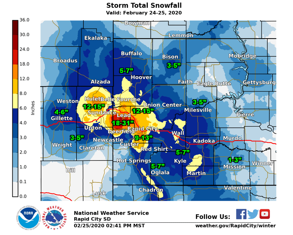 February 24-25, 2020 Preliminary Snowfall Map
The storm reports listed below are in descending order and may not
necessarily be the final storm reports.

Snow reports listed by amount

 INCHES  LOCATION                 ST  COUNTY           TIME
 ------  -----------------------  --  --------------   -------
 31.00   2 ESE LEAD               SD  LAWRENCE         1125 AM
 30.00   5 SE CHEYENNE CROSSING   SD  LAWRENCE         1230 PM
 30.00   2 S TERRY PEAK           SD  LAWRENCE         1020 AM
 27.50   3 SSE LEAD               SD  LAWRENCE         1017 AM
 20.00   11 SW CHEYENNE CROSSING  SD  LAWRENCE         1105 AM
 20.00   10 S DEADWOOD            SD  LAWRENCE         1014 AM
 20.00   6 SSW LEAD               SD  LAWRENCE         0700 AM
 18.00   DEADWOOD                 SD  LAWRENCE         0935 AM
 17.00   3 ENE DEADWOOD           SD  LAWRENCE         1151 AM
 17.00   LEAD                     SD  LAWRENCE         0900 AM
 15.80   1 NNW PIEDMONT           SD  MEADE            1227 PM
 15.00   HULETT                   WY  CROOK            0650 AM
 14.00   2 NNW SAINT ONGE         SD  LAWRENCE         1220 PM
 14.00   1 SW ROCKERVILLE         SD  PENNINGTON       1034 AM
 14.00   DWTN SPEARFISH           SD  LAWRENCE         0839 AM
 13.00   1 W WHITEWOOD            SD  LAWRENCE         1146 AM
 13.00   2 S DWTN RAPID CITY      SD  PENNINGTON       1029 AM
 12.00   SUMMERSET                SD  MEADE            1036 AM
 12.00   NNW DWTN SPEARFISH       SD  LAWRENCE         0830 AM
 12.00   SPEARFISH                SD  LAWRENCE         0800 AM
 11.50   SUMMERSET                SD  MEADE            0930 AM
 11.50   1 NNW PIEDMONT           SD  MEADE            0631 AM
 11.00   2 SW DWTN RAPID CITY     SD  PENNINGTON       0915 AM
 10.60   1 E DWTN RAPID CITY      SD  PENNINGTON       1057 AM
 10.00   1 SSE BELLE FOURCHE      SD  BUTTE            1237 PM
 10.00   4 S DEVILS TOWER         WY  CROOK            1233 PM
 10.00   3 SW DWTN RAPID CITY     SD  PENNINGTON       1043 AM
 10.00   1 E DWTN RAPID CITY      SD  PENNINGTON       1040 AM
 10.00   PINE HAVEN               WY  CROOK            1036 AM
 10.00   4 W HERMOSA              SD  CUSTER           1035 AM
 10.00   5 WNW HERMOSA            SD  CUSTER           1027 AM
 10.00   1 SE BUCKHORN            WY  WESTON           0854 AM
 10.00   4 S DWTN RAPID CITY      SD  PENNINGTON       0808 AM
  9.50   STURGIS                  SD  MEADE            1033 AM
  9.50   3 WNW DWTN RAPID CITY    SD  PENNINGTON       0700 AM
  9.50   ROCKERVILLE              SD  PENNINGTON       0530 AM
  9.10   DUPREE                   SD  LAWRENCE         0900 AM
  9.00   2 S DWTN RAPID CITY      SD  PENNINGTON       1147 AM
  9.00   7 W HERMOSA              SD  CUSTER           0610 AM
  8.70   1 WSW DWTN RAPID CITY    SD  PENNINGTON       0659 AM
  8.50   5 E PIEDMONT             SD  MEADE            0700 AM
  8.50   5 E PIEDMONT             SD  MEADE            0700 AM
  8.00   3 ENE PINE HAVEN         WY  CROOK            0932 AM
  8.00   6 NNE DWTN RAPID CITY    SD  MEADE            0830 AM
  8.00   1 SW HERMOSA             SD  CUSTER           0742 AM
  8.00   2 NW DWTN RAPID CITY     SD  PENNINGTON       0700 AM
  8.00   5 SW DWTN RAPID CITY     SD  PENNINGTON       0700 AM
  8.00   7 NNW DWTN SPEARFISH     SD  LAWRENCE         0700 AM
  8.00   2 ESE DEVILS TOWER       WY  CROOK            0600 AM
  8.00   SUNDANCE                 WY  CROOK            0600 AM
  8.00   HERMOSA                  SD  CUSTER           0500 AM
  7.00   2 W DWTN SPEARFISH       SD  LAWRENCE         0726 AM
  7.00   3 WNW DWTN SPEARFISH     SD  LAWRENCE         0700 AM
  6.50   1 SSE BELLE FOURCHE      SD  BUTTE            0700 AM
  6.50   1 SSE BELLE FOURCHE      SD  BUTTE            0700 AM
  6.00   WALL                     SD  PENNINGTON       1222 PM
  6.00   3 NNE CREIGHTON          SD  PENNINGTON       1221 PM
  6.00   5 ENE CUSTER             SD  CUSTER           1219 PM
  6.00   COLONY                   WY  CROOK            0934 AM
  6.00   UPTON                    WY  WESTON           0931 AM
  6.00   10 N DWTN GILLETTE       WY  CAMPBELL         0917 AM
  6.00   6 SW BEULAH              WY  CROOK            0800 AM
  6.00   8 NNE BOX ELDER          SD  MEADE            0700 AM
  6.00   4 NW DWTN RAPID CITY     SD  PENNINGTON       0600 AM
  6.00   4 NE DWTN RAPID CITY     SD  PENNINGTON       0600 AM
  5.90   4 NNW WHITEWOOD          SD  LAWRENCE         0530 AM
  5.50   DWTN GILLETTE            WY  CAMPBELL         1032 AM
  5.50   1 W NEWELL               SD  BUTTE            0800 AM
  5.50   1 SSW RAPID VALLEY       SD  PENNINGTON       0600 AM
  5.00   7 SSW CREIGHTON          SD  PENNINGTON       1221 PM
  5.00   5 ESE ELM SPRINGS        SD  MEADE            1221 PM
  5.00   CAMP CROOK               SD  HARDING          1004 AM
  5.00   MOORCROFT                WY  CROOK            0932 AM
  5.00   8 NW ROCKYPOINT          WY  CAMPBELL         0916 AM
  5.00   3 SE HARDING             SD  HARDING          0800 AM
  5.00   PACTOLA RES              SD  PENNINGTON       0800 AM
  5.00   KADOKA                   SD  JACKSON          0700 AM
  5.00   ORAL                     SD  FALL RIVER       0700 AM
  5.00   HEREFORD                 SD  MEADE            0611 AM
  5.00   HERMOSA                  SD  CUSTER           0600 AM
  5.00   4 SE DEERFIELD           SD  PENNINGTON       0333 AM
  4.00   8 WSW SWETT              SD  BENNETT          1224 PM
  4.00   6 NNW KYLE               SD  OGLALA LAKOTA    1223 PM
  4.00   PORCUPINE                SD  OGLALA LAKOTA    1223 PM
  4.00   19 S QUINN               SD  PENNINGTON       1222 PM
  4.00   6 N SCENIC               SD  PENNINGTON       1031 AM
  4.00   BISON                    SD  PERKINS          1005 AM
  4.00   BUFFALO                  SD  HARDING          1003 AM
  4.00   DWTN GILLETTE            WY  CAMPBELL         0918 AM
  4.00   RED OWL                  SD  MEADE            0705 AM
  4.00   2 SSW NORRIS             SD  MELLETTE         0700 AM
  4.00   21 NW FAITH              SD  PERKINS          0700 AM
  4.00   8 E MARTIN               SD  BENNETT          0600 AM
  3.70   3 WNW KADOKA             SD  JACKSON          0700 AM
  3.50   14 SSE ROZET             WY  CAMPBELL         0918 AM
  3.50   HOT SPRINGS              SD  FALL RIVER       0700 AM
  3.50   OPAL                     SD  MEADE            0700 AM
  3.50   17 NW WHITE RIVER        SD  MELLETTE         0600 AM
  3.20   HILL CITY                SD  PENNINGTON       0700 AM
  3.00   1 WNW OGLALA             SD  OGLALA LAKOTA    1224 PM
  3.00   13 S RED SHIRT           SD  OGLALA LAKOTA    1223 PM
  3.00   REVA                     SD  HARDING          1003 AM
  3.00   8 NE RENO JUNCTION       WY  CAMPBELL         0918 AM
  3.00   2 ENE WESTON             WY  CAMPBELL         0916 AM
  3.00   10 SE MEADOW             SD  PERKINS          0700 AM
  3.00   8 WNW USTA               SD  PERKINS          0632 AM
  3.00   10 ESE HERMOSA           SD  CUSTER           0630 AM
  3.00   4 SSW HILL CITY          SD  PENNINGTON       0556 AM
  2.50   11 NW UNION CENTER       SD  MEADE            0700 AM
  2.50   1 W NEWCASTLE            WY  WESTON           0700 AM
  2.50   ARGYLE                   SD  CUSTER           0655 AM
  2.50   13 ENE WHITE RIVER       SD  MELLETTE         0600 AM
  2.30   LEMMON                   SD  PERKINS          1005 AM
  2.00   3 SSE SORUM              SD  PERKINS          1004 AM
  2.00   4 N ROCHELLE             WY  WESTON           0930 AM
  2.00   1 SSW RENO JUNCTION      WY  CAMPBELL         0919 AM
  2.00   24 SW BISON              SD  PERKINS          0700 AM
  2.00   9 WSW RED ELM            SD  ZIEBACH          0642 AM
  1.90   1 W DOWNTOWN NEWCASTLE   WY  WESTON           0900 AM
  1.90   1 ESE NEWCASTLE          WY  WESTON           0800 AM
  1.50   1 E CLARETON             WY  WESTON           0931 AM
  1.30   5 SE OLSONVILLE          SD  TODD             0600 AM
  1.10   5 SW LODGEPOLE           SD  PERKINS          0735 AM
  1.00   1 NNE EDGEMONT           SD  FALL RIVER       0728 AM
  1.00   14 S MISSION             SD  TODD             0700 AM
  1.00   EDGEMONT                 SD  FALL RIVER       0700 AM
Photos
 |
 |
 |
 |
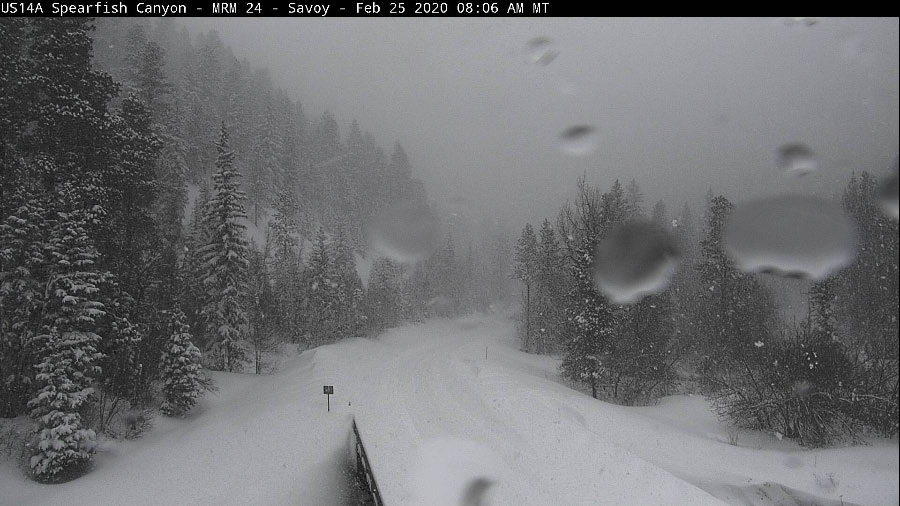
| US14A near Savoy, SD Courtesy SDDOT Webcams |
4S Devil's Tower Courtesy Heike B. |
4S Gillette, WY Courtesy Pat S. |
6N Scenic, SD Courtesy Heather M. |
 |
 |
 |
 |
| 8SW Rapid City, SD Courtesy Ben N. |
Black Hawk, SD Courtesy Paula R. |
Gillette, WY Courtesy Jill O. |
Highway 85 near Terry Peak Courtesy Amanda P. |
 |
 |
 |
 |
| Lead, SD Courtesy Shane M. |
Rapid City, SD Courtesy Trevor B. |
Goat in the Snow, SD Courtesy Holly D. |
Spearfish, SD Courtesy Alex E. |
Radar
Radar animation from early February 24 to midday February 25, 2020.
 |
Media use of NWS Web News Stories is encouraged! Please acknowledge the NWS as the source of any news information accessed from this site. |
|

