
Tropical Depression Two is expected to gradually strengthen and could bring tropical storm conditions to the Florida Panhandle beginning late Monday. Areas of flash flooding will be possible through Thursday along the eastern and central Gulf Coast. Severe thunderstorms will develop and move along a cold front crossing the Upper Midwest Monday, and through the Ohio Valley/Mid-Atlantic on Tuesday. Read More >
Overview
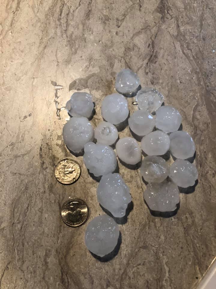
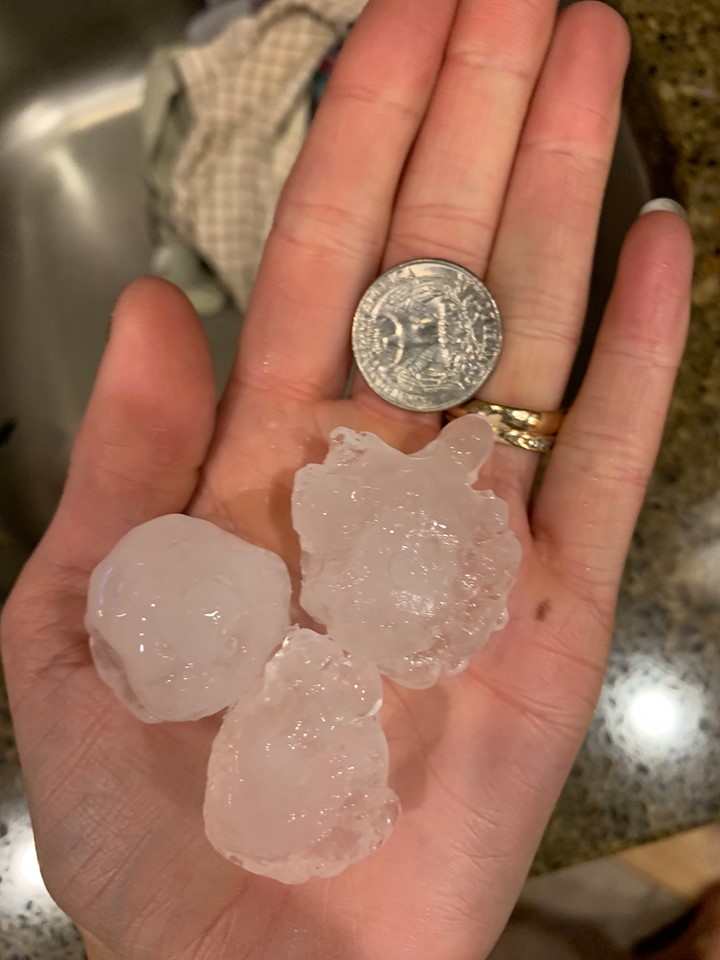
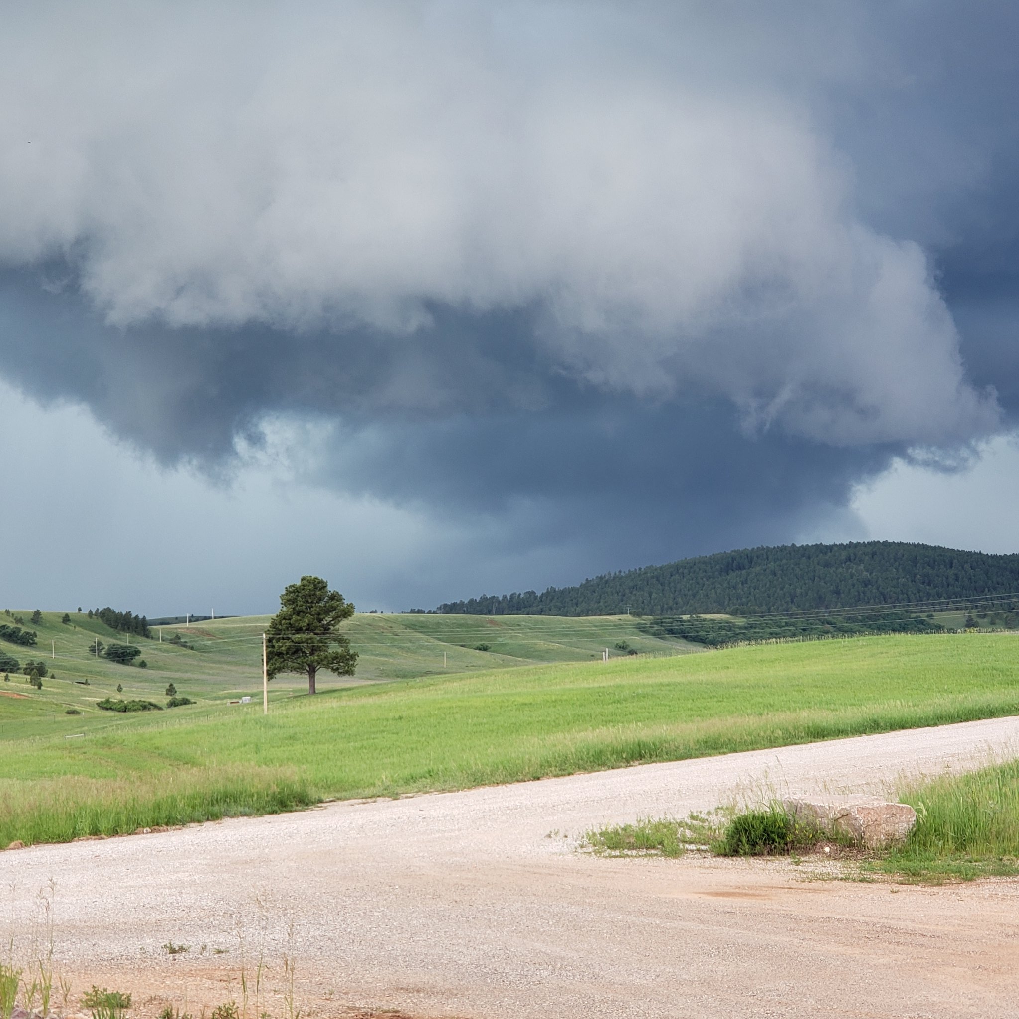
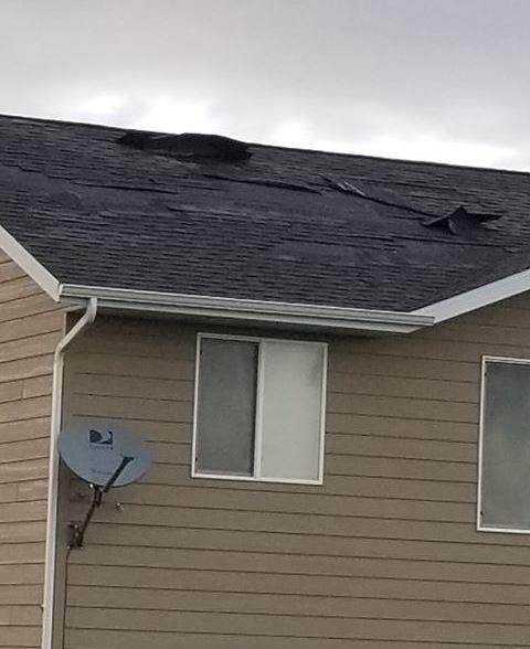
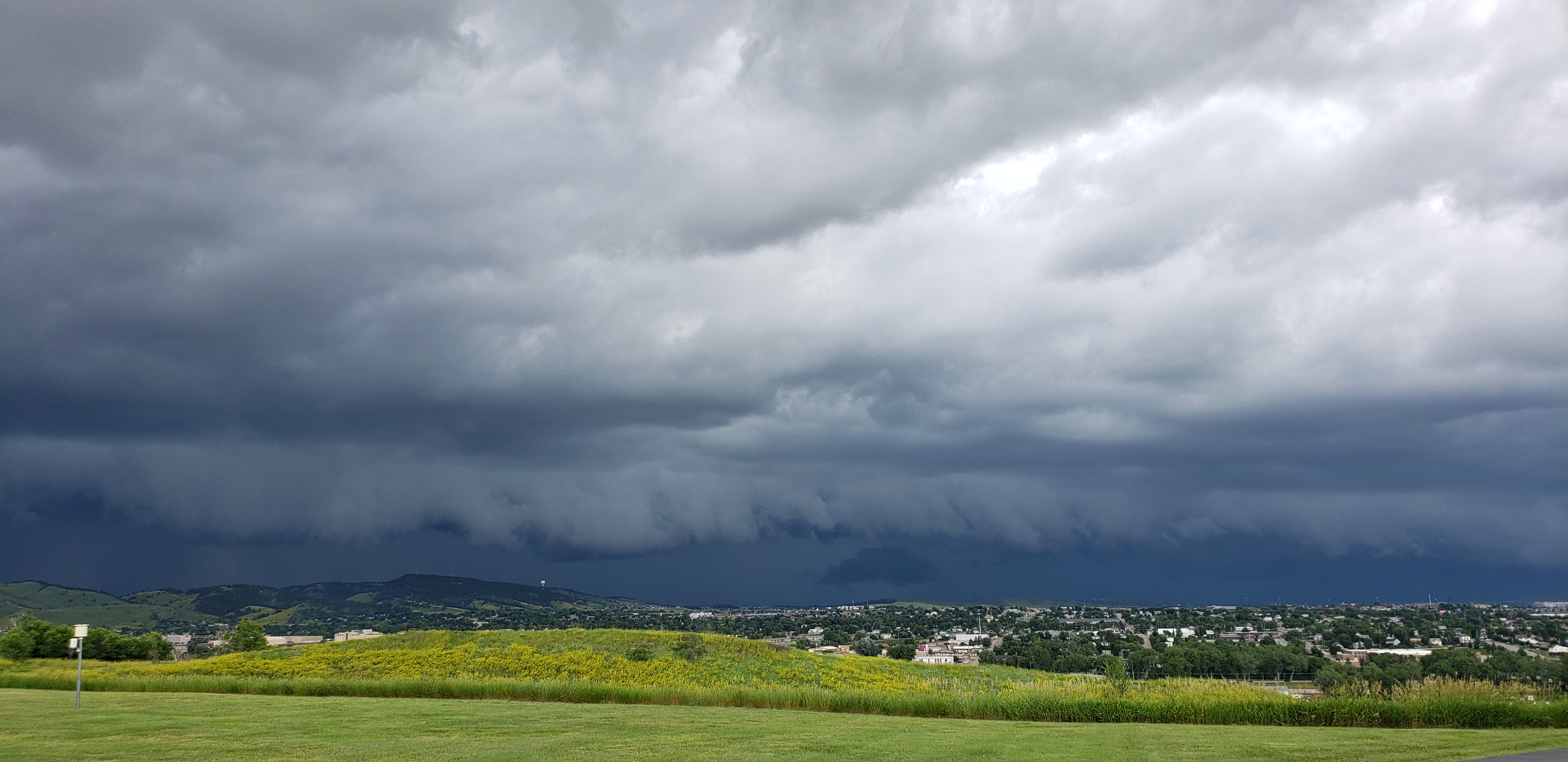
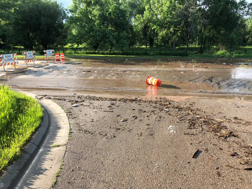
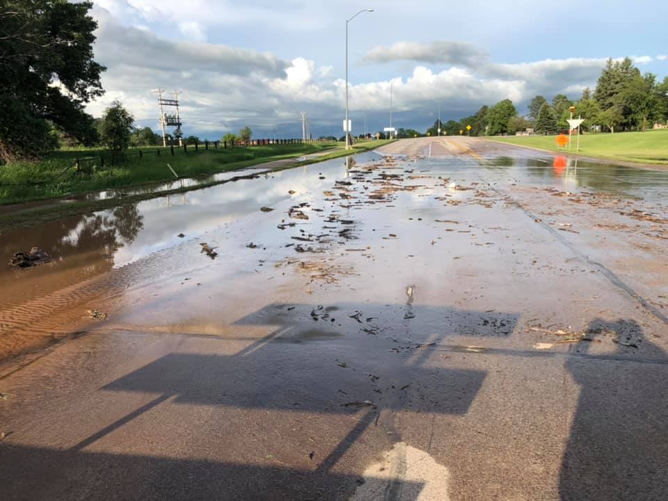
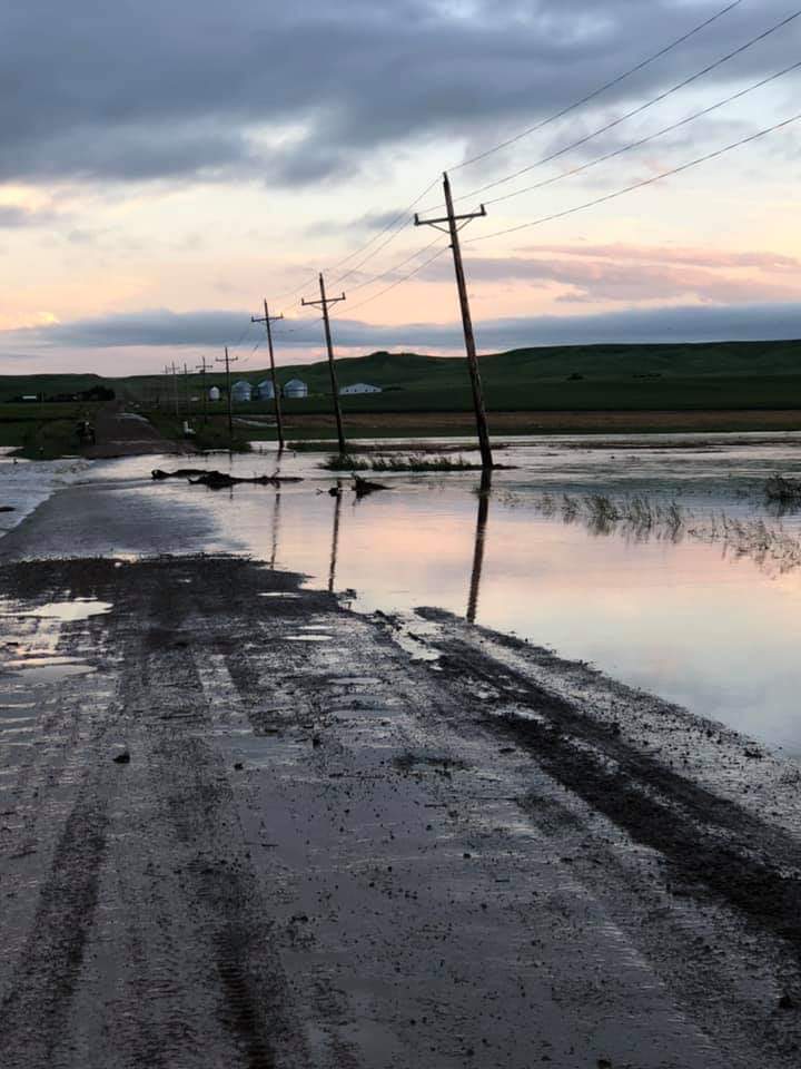
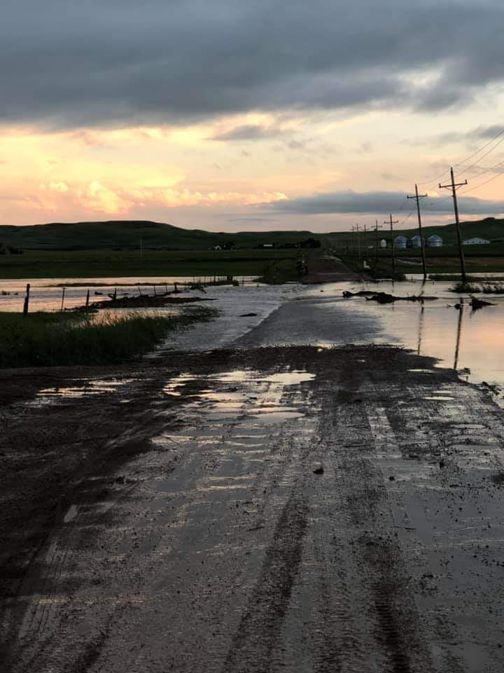
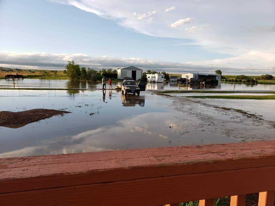
More severe thunderstorms moved through northeastern Wyoming and western South Dakota during the afternoon and evening of July 5, 2019. Flash flooding once again impacted the City of Sturgis along Bear Butte Creek, with additional flooding along Elk Creek in southern Meade County, northeast of Rapid City. Golf ball sized hail was reported around Spearfish, with hail to the size of a half dollar around Weston and Aladdin in Wyoming and Tilford and Zeona in South Dakota. Strong winds were reported north of Ellsworth Air Force Base and west of Faith in South Dakota and around Hulett in Wyoming.Photos & Video
Header
 |
 |
 |
 |
| Hail in Spearfish (Amanda Breann) |
Hail in Spearfish (Michelle Kvislen Keil) |
Storm west of Sundance (Katie Allen) |
Storm Damage north of Ellsworth (Carissa Williams) |
 |
|||
| View of the Storm from the National Weather Service in Rapid City | |||
 |
 |
||
| Flooding in Sturgis (Meade County EM) |
Flooding in Sturgis (Meade County EM) |
||
 |
 |
 |
| Elk Creek covering Antelope Creek Road north of Ellsworth AFB (Susan Cole) |
Elk Creek over Royal Run Road near 220th St and Antelope Creek Road north of Box Elder (Tinka Duran) |
|
Storm Reports
..TIME... ...EVENT... ...CITY LOCATION... ...LAT.LON...
..DATE... ....MAG.... ..COUNTY LOCATION..ST.. ...SOURCE....
..REMARKS..
0515 AM HEAVY RAIN 7 WSW FOLSOM 43.80N 102.99W
07/05/2019 M1.33 INCH CUSTER SD COCORAHS
RAINFALL LAST 24 HOURS.
0549 AM FLOOD 1 ENE STURGIS 44.42N 103.50W
07/05/2019 MEADE SD SOCIAL MEDIA
WATER INNUNDATED CITY PARK IN STURGIS
0610 AM HEAVY RAIN 1 ESE DWTN RAPID CITY 44.08N 103.21W
07/05/2019 M2.03 INCH PENNINGTON SD OFFICIAL NWS OBS
RAINFALL TOTAL YESTERDAY
0613 AM HEAVY RAIN 3 WNW KADOKA 43.85N 101.56W
07/05/2019 M1.00 INCH JACKSON SD COCORAHS
RAINFALL LAST 24 HOURS.
0630 AM HEAVY RAIN 4 NE ROCKERVILLE 44.00N 103.31W
07/05/2019 M1.74 INCH PENNINGTON SD COCORAHS
RAINFALL LAST 24 HOURS.
0630 AM HEAVY RAIN 1 NE DWTN RAPID CITY 44.10N 103.21W
07/05/2019 M2.32 INCH PENNINGTON SD COCORAHS
RAINFALL LAST 24 HOURS.
0645 AM HEAVY RAIN 7 NE SMITHWICK 43.37N 103.14W
07/05/2019 M1.45 INCH FALL RIVER SD COCORAHS
RAINFALL LAST 24 HOURS.
0645 AM HEAVY RAIN 6 SSW MYSTIC 44.00N 103.71W
07/05/2019 M1.18 INCH PENNINGTON SD COCORAHS
RAINFALL LAST 24 HOURS.
0700 AM HEAVY RAIN 5 ESE DWTN RAPID CITY 44.05N 103.13W
07/05/2019 M2.68 INCH PENNINGTON SD COCORAHS
0700 AM HEAVY RAIN 5 ESE PIEDMONT 44.21N 103.30W
07/05/2019 M2.79 INCH MEADE SD COCORAHS
0700 AM HEAVY RAIN 4 NE DWTN RAPID CITY 44.12N 103.18W
07/05/2019 M2.32 INCH PENNINGTON SD COCORAHS
0700 AM HEAVY RAIN 3 WNW DWTN RAPID CITY 44.10N 103.29W
07/05/2019 M2.20 INCH PENNINGTON SD COCORAHS
0700 AM HEAVY RAIN 2 SSE DWTN RAPID CITY 44.05N 103.21W
07/05/2019 M2.12 INCH PENNINGTON SD COCORAHS
0700 AM HEAVY RAIN 3 WNW DWTN RAPID CITY 44.09N 103.27W
07/05/2019 M1.99 INCH PENNINGTON SD COCORAHS
0700 AM HEAVY RAIN 5 SW DWTN RAPID CITY 44.03N 103.30W
07/05/2019 M1.91 INCH PENNINGTON SD COCORAHS
0700 AM HEAVY RAIN 6 ESE BOX ELDER 44.09N 102.96W
07/05/2019 M1.75 INCH PENNINGTON SD COCORAHS
0700 AM HEAVY RAIN 6 SW DWTN RAPID CITY 44.02N 103.32W
07/05/2019 M1.74 INCH PENNINGTON SD COCORAHS
0700 AM HEAVY RAIN 7 W DWTN RAPID CITY 44.08N 103.37W
07/05/2019 M1.49 INCH PENNINGTON SD COCORAHS
0700 AM HEAVY RAIN TILFORD 44.30N 103.43W
07/05/2019 M1.50 INCH MEADE SD COCORAHS
0700 AM HEAVY RAIN 12 SE BUFFALO GAP 43.37N 103.14W
07/05/2019 M1.45 INCH FALL RIVER SD COCORAHS
0700 AM HEAVY RAIN 22 SSW WASTA 43.78N 102.61W
07/05/2019 M1.37 INCH PENNINGTON SD COCORAHS
0700 AM HEAVY RAIN 2 ENE MIDLAND 44.08N 101.12W
07/05/2019 M1.35 INCH HAAKON SD COCORAHS
0700 AM HEAVY RAIN 10 ESE HERMOSA 43.78N 103.00W
07/05/2019 M1.33 INCH CUSTER SD COCORAHS
0700 AM HEAVY RAIN HOT SPRINGS 43.43N 103.48W
07/05/2019 M1.30 INCH FALL RIVER SD COCORAHS
0700 AM HEAVY RAIN 6 NNE DWTN RAPID CITY 44.16N 103.18W
07/05/2019 M1.29 INCH MEADE SD COCORAHS
0700 AM HEAVY RAIN 8 WNW HILL CITY 43.98N 103.73W
07/05/2019 M1.18 INCH PENNINGTON SD COCORAHS
0700 AM HEAVY RAIN 1 E WINNER 43.37N 99.83W
07/05/2019 M1.07 INCH TRIPP SD COCORAHS
0700 AM HEAVY RAIN 10 WNW DWTN RAPID CITY 44.13N 103.40W
07/05/2019 M1.06 INCH PENNINGTON SD COCORAHS
0700 AM HEAVY RAIN 3 NNW LEAD 44.39N 103.79W
07/05/2019 M1.04 INCH LAWRENCE SD COCORAHS
0700 AM HEAVY RAIN 3 WNW KADOKA 43.85N 101.56W
07/05/2019 M1.00 INCH JACKSON SD COCORAHS
0700 AM HEAVY RAIN 4 W HOT SPRINGS 43.43N 103.56W
07/05/2019 M0.96 INCH FALL RIVER SD COCORAHS
0700 AM HEAVY RAIN 3 SE PHILIP 44.02N 101.63W
07/05/2019 M0.93 INCH HAAKON SD COCORAHS
0700 AM HEAVY RAIN 7 ENE NEWELL 44.75N 103.29W
07/05/2019 M0.88 INCH BUTTE SD COCORAHS
0700 AM HEAVY RAIN 7 NNE BATESLAND 43.23N 102.05W
07/05/2019 M0.84 INCH BENNETT SD COCORAHS
0700 AM HEAVY RAIN 14 ENE MARTIN 43.25N 101.47W
07/05/2019 M0.83 INCH BENNETT SD COCORAHS
0700 AM HEAVY RAIN 2 SSW NORRIS 43.44N 101.22W
07/05/2019 M0.83 INCH MELLETTE SD COCORAHS
0700 AM HEAVY RAIN HERMOSA 43.84N 103.19W
07/05/2019 M0.81 INCH CUSTER SD COCORAHS
0700 AM HEAVY RAIN 4 SSW HILL CITY 43.87N 103.61W
07/05/2019 M0.70 INCH PENNINGTON SD COCORAHS
0700 AM HEAVY RAIN VALE 44.62N 103.40W
07/05/2019 M0.66 INCH BUTTE SD COCORAHS
0700 AM HEAVY RAIN 4 NNW WHITEWOOD 44.52N 103.67W
07/05/2019 M0.51 INCH LAWRENCE SD COCORAHS
0700 AM HEAVY RAIN 1 SSE BELLE FOURCHE 44.66N 103.84W
07/05/2019 M0.66 INCH BUTTE SD COCORAHS
0700 AM HEAVY RAIN 20 SSE BISON 45.25N 102.31W
07/05/2019 M0.51 INCH PERKINS SD COCORAHS
0700 AM HEAVY RAIN 10 NNW WINNER 43.51N 99.94W
07/05/2019 M0.66 INCH TRIPP SD COCORAHS
0700 AM HEAVY RAIN 15 SSE BELVIDERE 43.63N 101.16W
07/05/2019 M0.64 INCH MELLETTE SD COCORAHS
0700 AM HEAVY RAIN 14 SSE MISSION 43.12N 100.55W
07/05/2019 M0.64 INCH TODD SD COCORAHS
0700 AM HEAVY RAIN 17 NW WHITE RIVER 43.74N 100.99W
07/05/2019 M0.59 INCH MELLETTE SD COCORAHS
0700 AM HEAVY RAIN 24 SW BISON 45.28N 102.81W
07/05/2019 M0.56 INCH PERKINS SD COCORAHS
0700 AM HEAVY RAIN 7 NNW DWTN SPEARFISH 44.59N 103.91W
07/05/2019 M0.55 INCH LAWRENCE SD COCORAHS
0700 AM HEAVY RAIN 36 W FAITH 45.01N 102.77W
07/05/2019 M0.55 INCH MEADE SD COCORAHS
0700 AM HEAVY RAIN 13 ENE WHITE RIVER 43.64N 100.51W
07/05/2019 M0.53 INCH MELLETTE SD COCORAHS
0700 AM HEAVY RAIN 4 NNW TILFORD 44.35N 103.46W
07/05/2019 M3.60 INCH MEADE SD TRAINED SPOTTER
3.6 INCHES OF RAIN OVER THE NIGHT OF JULY 4TH.
0753 AM HEAVY RAIN HILL CITY 43.93N 103.58W
07/05/2019 M0.84 INCH PENNINGTON SD NWS EMPLOYEE
0800 AM FLOOD 2 N ARDMORE 43.05N 103.66W
07/05/2019 FALL RIVER SD LAW ENFORCEMENT
HWY 71 CLOSED NEAR 471 WATER RUNNING OVER THE ROADWAY
0800 AM HEAVY RAIN 2 E PIEDMONT 44.23N 103.35W
07/05/2019 M2.77 INCH MEADE SD PUBLIC
0836 AM HEAVY RAIN 2 E COTTONWOOD 43.96N 101.86W
07/05/2019 M1.23 INCH JACKSON SD CO-OP OBSERVER
0836 AM HEAVY RAIN 5 E ELM SPRINGS 44.32N 102.42W
07/05/2019 M1.07 INCH MEADE SD CO-OP OBSERVER
0837 AM HEAVY RAIN HILL CITY 43.94N 103.57W
07/05/2019 M1.09 INCH PENNINGTON SD CO-OP OBSERVER
0838 AM HEAVY RAIN 3 ENE KYLE 43.44N 102.14W
07/05/2019 M0.96 INCH OGLALA LAKOTA SD CO-OP OBSERVER
0838 AM HEAVY RAIN 2 W OPAL 44.89N 102.49W
07/05/2019 M0.50 INCH MEADE SD CO-OP OBSERVER
0839 AM HEAVY RAIN 7 E LAKEVIEW 43.11N 100.61W
07/05/2019 M1.06 INCH TODD SD CO-OP OBSERVER
0839 AM HEAVY RAIN MOUNT RUSHMORE 43.88N 103.46W
07/05/2019 M1.31 INCH PENNINGTON SD CO-OP OBSERVER
0840 AM HEAVY RAIN ORAL 43.40N 103.27W
07/05/2019 M1.36 INCH FALL RIVER SD CO-OP OBSERVER
0841 AM HEAVY RAIN 1 ESE PACTOLA RESERVOIR 44.06N 103.48W
07/05/2019 M0.88 INCH PENNINGTON SD CO-OP OBSERVER
0841 AM HEAVY RAIN 4 NW DOWNTOWN RAPID CIT 44.11N 103.28W
07/05/2019 M1.91 INCH PENNINGTON SD CO-OP OBSERVER
0843 AM HEAVY RAIN RED OWL 44.70N 102.55W
07/05/2019 M0.90 INCH MEADE SD CO-OP OBSERVER
0945 AM FLOOD 1 E STURGIS 44.41N 103.49W
07/05/2019 MEADE SD EMERGENCY MNGR
WATER AND DEBRIS OVER HIGHWAY 34.
1010 AM HEAVY RAIN STURGIS 44.41N 103.51W
07/05/2019 M5.25 INCH MEADE SD BROADCAST MEDIA
1047 AM FLOOD 5 SE DWTN RAPID CITY 44.03N 103.15W
07/05/2019 PENNINGTON SD PUBLIC
RAPID CREEK OUT OF ITS BANKS NEAR THE WATER TREATMENT
PLANT
1227 PM HEAVY RAIN SMITHWICK 43.30N 103.22W
07/05/2019 M5.00 INCH FALL RIVER SD PUBLIC
0120 PM HAIL 9 SSE WESTON 44.51N 105.26W
07/05/2019 E1.25 INCH CAMPBELL WY PUBLIC
BRANCHES BROKEN OFF TREES.
0228 PM TSTM WND GST HULETT 44.68N 104.60W
07/05/2019 E60 MPH CROOK WY TRAINED SPOTTER
0233 PM FLOOD 3 S LEAD 44.31N 103.77W
07/05/2019 LAWRENCE SD EMERGENCY MNGR
WATER IS STILL OVER THE ROAD AT RUBY FLATS AND
ENGLEWOOD RD
0233 PM FLOOD 5 NE GALENA 44.39N 103.59W
07/05/2019 LAWRENCE SD EMERGENCY MNGR
BEAR BUTTE CREEK IS STILL OVER ROAD IN BOULDER CANYON
NEAR THE GOLF COURSE
0300 PM HAIL 19 S REVA 45.27N 103.05W
07/05/2019 E1.00 INCH HARDING SD TRAINED SPOTTER
0311 PM HAIL 10 W HARDING 45.41N 104.03W
07/05/2019 E1.00 INCH HARDING SD TRAINED SPOTTER
0315 PM HAIL ALADDIN 44.64N 104.18W
07/05/2019 E1.25 INCH CROOK WY TRAINED SPOTTER
0323 PM HAIL 2 NE SUNDANCE 44.42N 104.35W
07/05/2019 E1.00 INCH CROOK WY TRAINED SPOTTER
0324 PM HEAVY RAIN SUNDANCE 44.41N 104.37W
07/05/2019 M0.54 INCH CROOK WY TRAINED SPOTTER
THIS WAS MEASURED FROM THE RAIN THEY RECIEVED IN THE
LAST 20 MINUTES. IT WAS STILL RAINING AFTER THE CALL.
0330 PM HAIL 10 WNW DWTN SPEARFISH 44.55N 104.04W
07/05/2019 E1.00 INCH LAWRENCE SD STORM CHASER
0341 PM HAIL DWTN SPEARFISH 44.50N 103.86W
07/05/2019 E1.25 INCH LAWRENCE SD LAW ENFORCEMENT
0345 PM HAIL 2 ESE ZEONA 45.18N 102.89W
07/05/2019 E1.25 INCH PERKINS SD PUBLIC
0345 PM HAIL DWTN SPEARFISH 44.50N 103.86W
07/05/2019 E1.50 INCH LAWRENCE SD PUBLIC
0347 PM HAIL 2 WNW DWTN SPEARFISH 44.51N 103.89W
07/05/2019 E1.75 INCH LAWRENCE SD TRAINED SPOTTER
0359 PM HAIL 3 ESE DWTN SPEARFISH 44.48N 103.81W
07/05/2019 E1.25 INCH LAWRENCE SD PUBLIC
0400 PM HAIL 2 SSW SAINT ONGE 44.53N 103.73W
07/05/2019 E0.88 INCH LAWRENCE SD TRAINED SPOTTER
0402 PM HEAVY RAIN 2 WNW DWTN SPEARFISH 44.51N 103.89W
07/05/2019 M0.67 INCH LAWRENCE SD TRAINED SPOTTER
FELL IN 20 MINUTES
0415 PM HEAVY RAIN 9 WSW RED ELM 44.99N 101.96W
07/05/2019 M0.80 INCH ZIEBACH SD TRAINED SPOTTER
0.80 IN JUST UNDER AN HOUR
0424 PM HAIL 5 SE WHITEWOOD 44.40N 103.57W
07/05/2019 E1.50 INCH LAWRENCE SD PUBLIC
0425 PM HAIL 2 NNE BROWNSVILLE 44.30N 103.68W
07/05/2019 E0.70 INCH LAWRENCE SD TRAINED SPOTTER
0430 PM HAIL 1 SW STURGIS 44.40N 103.53W
07/05/2019 E1.00 INCH MEADE SD TRAINED SPOTTER
0430 PM TSTM WND GST 1 SW STURGIS 44.40N 103.53W
07/05/2019 E50 MPH MEADE SD TRAINED SPOTTER
0440 PM HAIL 4 NNW TILFORD 44.35N 103.46W
07/05/2019 E1.25 INCH MEADE SD TRAINED SPOTTER
0440 PM TSTM WND GST 4 NNW TILFORD 44.35N 103.46W
07/05/2019 E50 MPH MEADE SD TRAINED SPOTTER
0539 PM TSTM WND GST 7 NNE ELLSWORTH AFB 44.23N 103.04W
07/05/2019 M60 MPH MEADE SD NWS EMPLOYEE
0540 PM TSTM WND GST 5 NNE ELLSWORTH AFB 44.22N 103.05W
07/05/2019 E65 MPH MEADE SD PUBLIC
0600 PM HAIL ROCKERVILLE 43.96N 103.36W
07/05/2019 E1.00 INCH PENNINGTON SD PUBLIC
0600 PM HAIL 3 NNW KEYSTONE 43.92N 103.44W
07/05/2019 E0.75 INCH PENNINGTON SD PUBLIC
0600 PM HEAVY RAIN 14 SSE HEREFORD 44.19N 102.83W
07/05/2019 M0.61 INCH MEADE SD TRAINED SPOTTER
RAINFALL IN THE LAST HOUR.
0615 PM FLOOD 2 E BLACK HAWK 44.15N 103.28W
07/05/2019 MEADE SD FIRE DEPT/RESCUE
WATER OVER PEACEFUL PINES ROAD
0632 PM HEAVY RAIN 9 WSW RED ELM 44.99N 101.96W
07/05/2019 M0.55 INCH ZIEBACH SD TRAINED SPOTTER
FELL IN 20 MINUTES
0645 PM TSTM WND GST WASTA 44.07N 102.45W
07/05/2019 E60 MPH PENNINGTON SD CO-OP OBSERVER
DELAYED REPORT. TIME ESTIMATED FROM RADAR.
0645 PM HAIL WASTA 44.07N 102.45W
07/05/2019 E0.88 INCH PENNINGTON SD CO-OP OBSERVER
DELAYED REPORT. TIME ESTIMATED FROM RADAR.
0650 PM HEAVY RAIN 5 NE ELLSWORTH AFB 44.20N 103.03W
07/05/2019 M1.40 INCH MEADE SD PUBLIC
1.4" OF RAIN IN 20 MINUTES. WATER OVER ANTELOPE CREEK
ROAD IN SEVERAL PLACES.
0650 PM FLOOD 5 NE ELLSWORTH AFB 44.20N 103.03W
07/05/2019 MEADE SD PUBLIC
1.4" OF RAIN IN 20 MINUTES. WATER OVER ANTELOPE CREEK
ROAD IN SEVERAL PLACES.
&&
THE STORM REPORTS LISTED BELOW ARE IN DESCENDING ORDER AND MAY NOT
NECESSARILY BE THE FINAL STORM REPORTS.
HAIL REPORTS LISTED BY SIZE (INCHES)
SIZE LOCATION ST COUNTY TIME
------ ----------------------- -- -------------- -------
1.75 2 WNW DWTN SPEARFISH SD LAWRENCE 0347 PM
1.50 5 SE WHITEWOOD SD LAWRENCE 0424 PM
1.50 DWTN SPEARFISH SD LAWRENCE 0345 PM
1.25 4 NNW TILFORD SD MEADE 0440 PM
1.25 3 ESE DWTN SPEARFISH SD LAWRENCE 0359 PM
1.25 2 ESE ZEONA SD PERKINS 0345 PM
1.25 DWTN SPEARFISH SD LAWRENCE 0341 PM
1.25 ALADDIN WY CROOK 0315 PM
1.25 9 SSE WESTON WY CAMPBELL 0120 PM
1.00 ROCKERVILLE SD PENNINGTON 0600 PM
1.00 1 SW STURGIS SD MEADE 0430 PM
1.00 10 WNW DWTN SPEARFISH SD LAWRENCE 0330 PM
1.00 2 NE SUNDANCE WY CROOK 0323 PM
1.00 10 W HARDING SD HARDING 0311 PM
1.00 19 S REVA SD HARDING 0300 PM
0.88 WASTA SD PENNINGTON 0645 PM
0.88 2 SSW SAINT ONGE SD LAWRENCE 0400 PM
0.75 3 NNW KEYSTONE SD PENNINGTON 0600 PM
0.70 2 NNE BROWNSVILLE SD LAWRENCE 0425 PM
TSTM WIND REPORTS LISTED BY SPEED (MPH)
SPEED LOCATION ST COUNTY TIME
------ ----------------------- -- -------------- -------
65.00 5 NNE ELLSWORTH AFB SD MEADE 0540 PM
60.00 WASTA SD PENNINGTON 0645 PM
60.00 7 NNE ELLSWORTH AFB SD MEADE 0539 PM
60.00 HULETT WY CROOK 0228 PM
50.00 4 NNW TILFORD SD MEADE 0440 PM
50.00 1 SW STURGIS SD MEADE 0430 PM
RAIN AMOUNTS (INCHES)
AMOUNT LOCATION ST COUNTY TIME
------ ----------------------- -- -------------- -------
5.25 STURGIS SD MEADE 1010 AM
5.00 SMITHWICK SD FALL RIVER 1227 PM
3.60 4 NNW TILFORD SD MEADE 0700 AM
2.79 5 ESE PIEDMONT SD MEADE 0700 AM
2.77 2 E PIEDMONT SD MEADE 0800 AM
2.68 5 ESE DWTN RAPID CITY SD PENNINGTON 0700 AM
2.32 4 NE DWTN RAPID CITY SD PENNINGTON 0700 AM
2.32 1 NE DWTN RAPID CITY SD PENNINGTON 0630 AM
2.20 3 WNW DWTN RAPID CITY SD PENNINGTON 0700 AM
2.12 2 SSE DWTN RAPID CITY SD PENNINGTON 0700 AM
2.03 1 ESE DWTN RAPID CITY SD PENNINGTON 0610 AM
1.99 3 WNW DWTN RAPID CITY SD PENNINGTON 0700 AM
1.91 4 NW DOWNTOWN RAPID CIT SD PENNINGTON 0841 AM
1.91 5 SW DWTN RAPID CITY SD PENNINGTON 0700 AM
1.75 6 ESE BOX ELDER SD PENNINGTON 0700 AM
1.74 6 SW DWTN RAPID CITY SD PENNINGTON 0700 AM
1.74 4 NE ROCKERVILLE SD PENNINGTON 0630 AM
1.50 TILFORD SD MEADE 0700 AM
1.49 7 W DWTN RAPID CITY SD PENNINGTON 0700 AM
1.45 12 SE BUFFALO GAP SD FALL RIVER 0700 AM
1.45 7 NE SMITHWICK SD FALL RIVER 0645 AM
1.40 5 NE ELLSWORTH AFB SD MEADE 0650 PM
1.37 22 SSW WASTA SD PENNINGTON 0700 AM
1.36 ORAL SD FALL RIVER 0840 AM
1.35 2 ENE MIDLAND SD HAAKON 0700 AM
1.33 10 ESE HERMOSA SD CUSTER 0700 AM
1.33 7 WSW FOLSOM SD CUSTER 0515 AM
1.31 MOUNT RUSHMORE SD PENNINGTON 0839 AM
1.30 HOT SPRINGS SD FALL RIVER 0700 AM
1.29 6 NNE DWTN RAPID CITY SD MEADE 0700 AM
1.23 2 E COTTONWOOD SD JACKSON 0836 AM
1.18 8 WNW HILL CITY SD PENNINGTON 0700 AM
1.18 6 SSW MYSTIC SD PENNINGTON 0645 AM
1.09 HILL CITY SD PENNINGTON 0837 AM
1.07 5 E ELM SPRINGS SD MEADE 0836 AM
1.07 1 E WINNER SD TRIPP 0700 AM
1.06 7 E LAKEVIEW SD TODD 0839 AM
1.06 10 WNW DWTN RAPID CITY SD PENNINGTON 0700 AM
1.04 3 NNW LEAD SD LAWRENCE 0700 AM
1.00 3 WNW KADOKA SD JACKSON 0700 AM
1.00 3 WNW KADOKA SD JACKSON 0613 AM
0.96 3 ENE KYLE SD OGLALA LAKOTA 0838 AM
0.96 4 W HOT SPRINGS SD FALL RIVER 0700 AM
0.93 3 SE PHILIP SD HAAKON 0700 AM
0.90 RED OWL SD MEADE 0843 AM
0.88 1 ESE PACTOLA RESERVOIR SD PENNINGTON 0841 AM
0.88 7 ENE NEWELL SD BUTTE 0700 AM
0.84 HILL CITY SD PENNINGTON 0753 AM
0.84 7 NNE BATESLAND SD BENNETT 0700 AM
0.83 2 SSW NORRIS SD MELLETTE 0700 AM
0.83 14 ENE MARTIN SD BENNETT 0700 AM
0.81 HERMOSA SD CUSTER 0700 AM
0.80 9 WSW RED ELM SD ZIEBACH 0415 PM
0.70 4 SSW HILL CITY SD PENNINGTON 0700 AM
0.67 2 WNW DWTN SPEARFISH SD LAWRENCE 0402 PM
0.66 10 NNW WINNER SD TRIPP 0700 AM
0.66 1 SSE BELLE FOURCHE SD BUTTE 0700 AM
0.66 VALE SD BUTTE 0700 AM
0.64 14 SSE MISSION SD TODD 0700 AM
0.64 15 SSE BELVIDERE SD MELLETTE 0700 AM
0.61 14 SSE HEREFORD SD MEADE 0600 PM
0.59 17 NW WHITE RIVER SD MELLETTE 0700 AM
0.56 24 SW BISON SD PERKINS 0700 AM
0.55 9 WSW RED ELM SD ZIEBACH 0632 PM
0.55 36 W FAITH SD MEADE 0700 AM
0.55 7 NNW DWTN SPEARFISH SD LAWRENCE 0700 AM
0.54 SUNDANCE WY CROOK 0324 PM
0.53 13 ENE WHITE RIVER SD MELLETTE 0700 AM
0.51 20 SSE BISON SD PERKINS 0700 AM
0.51 4 NNW WHITEWOOD SD LAWRENCE 0700 AM
0.50 2 W OPAL SD MEADE 0838 AM
Environment and Radar
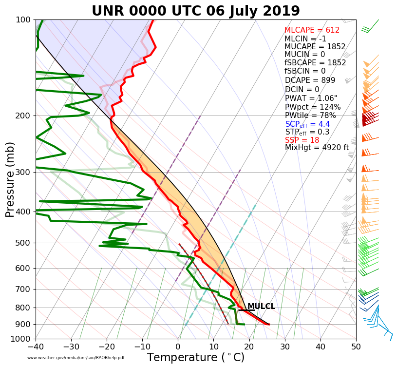
The weather balloon released from the NWS Office at 6 pm MDT on Friday, July 5th, 2019 continued to show an unstable atmosphere over the Black Hills area. The vertical wind shear (right image) was rather strong, which favored severe storms and damaging winds. Several strong to severe thunderstorms occurred across northeastern Wyoming and western South Dakota, as shown in the radar loop below.
 |
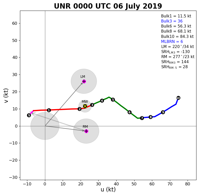 |
| July 5, 2019, 6 pm upper-air sounding for Rapid City (00z on the 6th) | July 5, 2019, 6 pm upper-air hodograph for Rapid City (00z on the 6th) |
| Radar loop during the afternoon of July 5, 2019 |
 |
Media use of NWS Web News Stories is encouraged! Please acknowledge the NWS as the source of any news information accessed from this site. |
|

