
Tropical Depression Two is expected to gradually strengthen and could bring tropical storm conditions to the Florida Panhandle beginning late Monday. Areas of flash flooding will be possible through Thursday along the eastern and central Gulf Coast. Severe thunderstorms will develop and move along a cold front crossing the Upper Midwest Monday, and through the Ohio Valley/Mid-Atlantic on Tuesday. Read More >
Overview
Thunderstorms developed quickly during the morning of June 2, 2019. A supercell thunderstorm formed near Tilford, South Dakota and moved through Rapid City, Hermosa, and Fairburn before dissipating by late afternoon. This storm produced large hail, which damaged homes, vehicles, and crops.Hail:
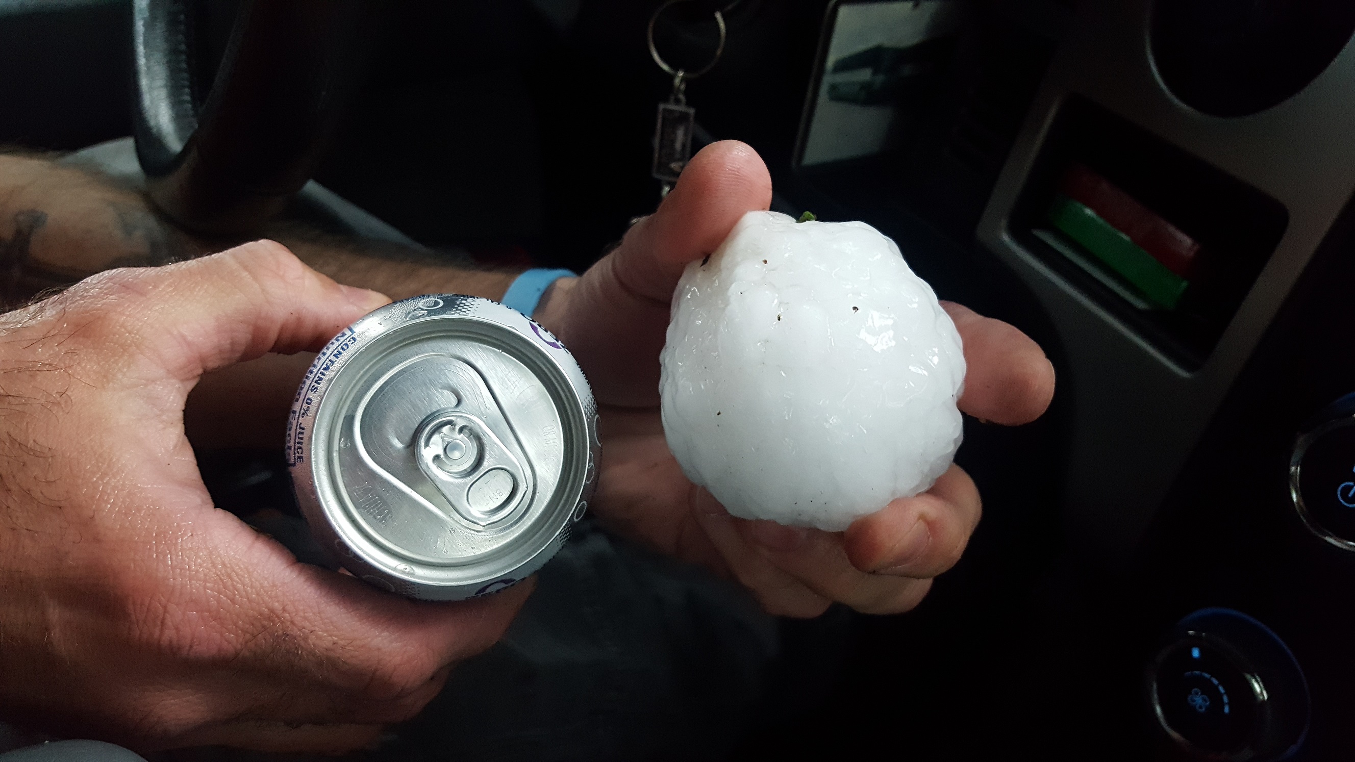 |
| Tennis ball sized hail near Fairburn, SD (Photo courtesy of Mikkel Skaare) |
View of the severe thunderstorm from along the Wildlife Loop plus ~2” diameter hailstones.
— Scott Larson KCAU June 2, 2019
2 inch hail at Hermosa SD this afternoon in Custer County SD. East side of Black Hills. Photo credit, Mark Neugebauer, area farmer.
— Jim Strain June 2, 2019
North of Buffalo Gap
— Tom A. Warner June 2, 2019
Holy cow folks. Just Southwest of Rapid City off of Neck Yoke road. Those are some MONSTERS even by South Dakota standards!
— Brant Beckman June 2, 2019
— Dave Hintz June 2, 2019
Just over 1 inch diameter hail 2 SSE downtown Rapid City at 12:31 p.m. 6/2/19
— Matthew Bunkers June 2, 2019
Meadowbrook area hail stones. My garden is ... not happy
— Stephany Chalberg June 2, 2019
Golf ball size hail. RIP car.
— David Stradling June 2, 2019
Hail!!!
— Arielle Zionts June 2, 2019
Radar
| Radar loop beginning at 854 am MDT and ending 424 pm MDT |
Storm Reports
THE STORM REPORTS LISTED BELOW ARE IN DESCENDING ORDER AND MAY NOT
NECESSARILY BE THE FINAL STORM REPORTS.
Hail reports listed by size (inches)
 SIZE    LOCATION                 ST  COUNTY           TIME
 ------  -----------------------  --  --------------   -------
  2.50   3 WNW FAIRBURN           SD  CUSTER           0238 PM
                 DELAYED REPORT; TIME ESTIMATED FROM RADAR
  2.50   1 SSW HERMOSA            SD  CUSTER           0200 PM
  2.25   9 WSW HERMOSA            SD  CUSTER           0206 PM
                 TIME ESTIMATED FROM RADAR
  2.25   4 SSW DOWNTOWN RAPID CI  SD  PENNINGTON       1240 PM
  2.00   1 W HERMOSA              SD  CUSTER           0148 PM
  2.00   5 SW DOWNTOWN RAPID CIT  SD  PENNINGTON       1224 PM
  2.00   5 SW DOWNTOWN RAPID CIT  SD  PENNINGTON       1220 PM
                 GOLF BALL TO EGG SIZED HAIL LASTED FOR 15
                 MINUTES
  1.75   7 WNW FAIRBURN           SD  CUSTER           0230 PM
  1.75   7 WNW FAIRBURN           SD  CUSTER           0230 PM
  1.75   2 WSW DOWNTOWN RAPID CI  SD  PENNINGTON       1230 PM
                 QUARTER TO GOLF BALL SIZED HAIL
  1.75   4 NE ROCKERVILLE         SD  PENNINGTON       1224 PM
  1.75   5 SW DOWNTOWN RAPID CIT  SD  PENNINGTON       1222 PM
  1.75   4 SSW DOWNTOWN RAPID CI  SD  PENNINGTON       1220 PM
  1.50   4 NNW FAIRBURN           SD  CUSTER           0220 PM
  1.50   5 NNW FAIRBURN           SD  CUSTER           0203 PM
                 PING PONG BALL SIZE HAIL FELL FOR 32 MINUTES.
  1.50   5 SW DOWNTOWN RAPID CIT  SD  PENNINGTON       1222 PM
  1.50   4 SW DOWNTOWN RAPID CIT  SD  PENNINGTON       1215 PM
  1.25   6 W HERMOSA              SD  CUSTER           0140 PM
                 THE LARGEST HAIL WAS HALF DOLLAR SIZE. THE
                 AVERAGE HAIL SIZE WAS PEA TO MARBLE.
  1.25   7 SW RAPID CITY AIRPORT  SD  PENNINGTON       0100 PM
  1.00   13 NW VETAL              SD  BENNETT          0525 PM
  1.00   12 ENE BUFFALO GAP       SD  CUSTER           0342 PM
  1.00   3 SE FAIRBURN            SD  CUSTER           0255 PM
  1.00   4 SSW DOWNTOWN RAPID CI  SD  PENNINGTON       1240 PM
  1.00   2 SSE DOWNTOWN RAPID CI  SD  PENNINGTON       1231 PM
  1.00   2 SW DOWNTOWN RAPID CIT  SD  PENNINGTON       1225 PM
  1.00   2 SW DOWNTOWN RAPID CIT  SD  PENNINGTON       1225 PM
  1.00   5 WSW DOWNTOWN RAPID CI  SD  PENNINGTON       1218 PM
  0.88   1 ESE DOWNTOWN RAPID CI  SD  PENNINGTON       1230 PM
  0.70   BLACK HAWK               SD  MEADE            1137 AM
                 HEAVY AMOUNT OF HAIL FALLING.
  0.70   1 NNW NEMO               SD  LAWRENCE         1114 AM
 |
Media use of NWS Web News Stories is encouraged! Please acknowledge the NWS as the source of any news information accessed from this site. |
|

