
Tropical Depression Two is expected to gradually strengthen and could bring tropical storm conditions to the Florida Panhandle beginning late Monday. Areas of flash flooding will be possible through Thursday along the eastern and central Gulf Coast. Severe thunderstorms will develop and move along a cold front crossing the Upper Midwest Monday, and through the Ohio Valley/Mid-Atlantic on Tuesday. Read More >
Overview
A cold front blasted across the area Sunday morning, with wind gusts around 50 mph. Once the snow started, visibility dropped to a quarter mile at times, creating hazardous travel conditions. Various bands of snow swept across the area through Tuesday morning, bringing several inches of accumulation. See below for snow reports and pictures.
Photos:
Snow around the area
 |
 |
 |
 |
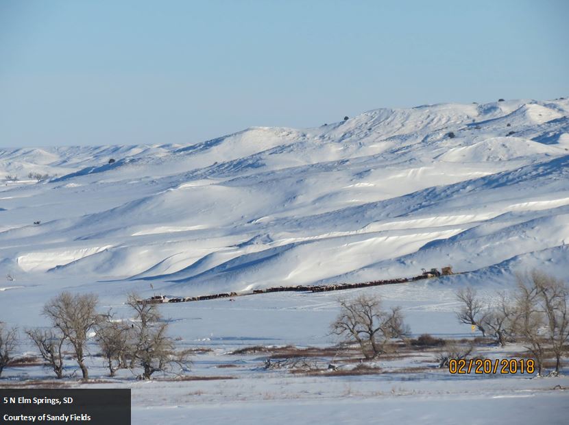
| 5 N Elm Springs, SD (Sandy Fields) |
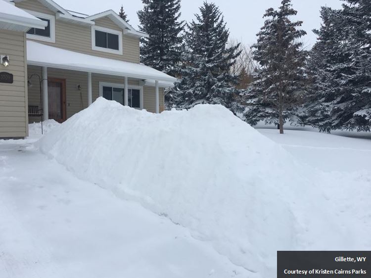
Gillette, WY (Kristen Cairns Parks) |
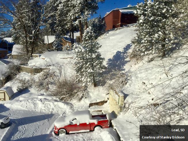
Lead, SD (Stanley Erickson) |
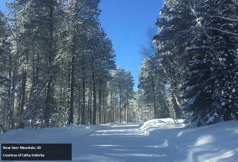
Near Deer Mountain, SD (Cathy Enderby) |
 |
 |
 |
 |
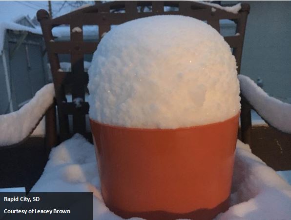
| Rapid City, SD (Leacey Brown) |
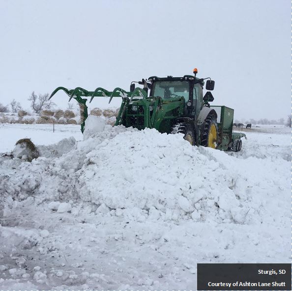
Sturgis, SD (Ashton Lane Shutt) |
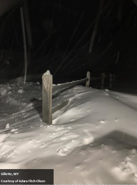
Gillette, WY (Adara Fitch-Olson) |
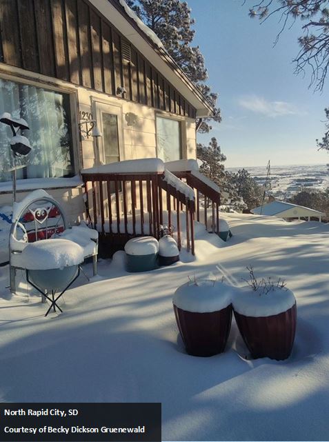
Rapid City, SD (Becky Dickson Gruenewald) |
 |
 |
 |
 |
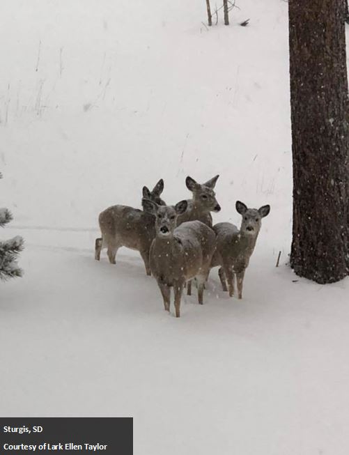
| Sturgis, SD (Lark Ellen Taylor) |
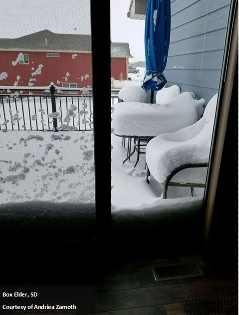
Box Elder, SD (Andriea Zarnoth) |
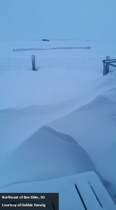
Northeast of Box Elder, SD (Debbie Harwig) |
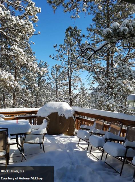
Black Hawk, SD (Aubrey McElroy) |
Storm Reports
Snow reports listed by amount

 INCHES  LOCATION                 ST  COUNTY           TIME
 ------  -----------------------  --  --------------   -------
 14.00   5 SW LEAD                SD  LAWRENCE         0900 AM
 13.00   2 ESE DOWNTOWN SPEARFISH SD  LAWRENCE         0705 PM
 12.50   LEAD                     SD  LAWRENCE         0200 PM
 12.00   10 S FOLSOM              SD  CUSTER           0900 AM
 12.00   6 WNW DOWNTOWN CUSTER    SD  CUSTER           0900 AM
 12.00   5 N ELM SPRINGS          SD  MEADE            0900 AM
 12.00   LEAD                     SD  LAWRENCE         0900 AM
 12.00   1 SSW HOT SPRINGS        SD  FALL RIVER       0700 AM
 12.00   4 NW DOWNTOWN RAPID CITY SD  PENNINGTON       0600 AM
 12.00   WHITEWOOD                SD  LAWRENCE         0715 PM
 12.00   BEULAH                   WY  CROOK            0547 PM
 12.00   PINE HAVEN               WY  CROOK            0546 PM
 12.00   8 N WALL                 SD  PENNINGTON       0545 PM
 11.50   6 NNE DOWNTOWN RAPID CITYSD  MEADE            0700 AM
 11.50   4 SSW HILL CITY          SD  PENNINGTON       0545 AM
 11.50   PACTOLA RESERVOIR        SD  PENNINGTON       0458 PM
 11.00   7 WNW NEWELL             SD  BUTTE            1034 AM
 11.00   6 NNW KIRLEY             SD  HAAKON           0900 AM
 11.00   2 NW BUFFALO GAP         SD  CUSTER           0900 AM
                 1/2 MILE VISIBILITY AT TIMES ON MONDAY.
 11.00   16 SSW ROZET             WY  CAMPBELL         0900 AM
 11.00   5 ESE ELM SPRINGS        SD  MEADE            0851 PM
 11.00   DOWNTOWN HOT SPRINGS     SD  FALL RIVER       0717 PM
 11.00   1 SSW RAPID VALLEY       SD  PENNINGTON       0408 PM
 10.80   1 E DOWNTOWN RAPID CITY  SD  PENNINGTON       0913 PM
 10.50   2 W HAYWARD              SD  PENNINGTON       0900 AM
 10.10   4 NNW WHITEWOOD          SD  LAWRENCE         0500 AM
 10.00   CEDAR PASS               SD  JACKSON          0900 AM
 10.00   12 NNW ALVA              WY  CROOK            0900 AM
 10.00   15 NNW ALVA              WY  CROOK            0900 AM
 10.00   1 WSW PRAIRIE CITY       SD  PERKINS          0900 AM
                 TOTAL SNOWFALL 8 TO 12 INCHES. AMOUNT
                 ESTIMATED DUE TO BLOWING AND DRIFTING.
 10.00   8 SW HOT SPRINGS         SD  FALL RIVER       0900 AM
 10.00   10 WNW PHILIP            SD  HAAKON           0900 AM
 10.00   1 NE BOX ELDER           SD  PENNINGTON       0900 AM
 10.00   DOWNTOWN SPEARFISH       SD  LAWRENCE         0800 AM
 10.00   1 W DOWNTOWN NEWCASTLE   WY  WESTON           0700 AM
 10.00   ORAL                     SD  FALL RIVER       0700 AM
 10.00   1 SSW BELLE FOURCHE      SD  BUTTE            1043 PM
 10.00   4 NE ROCKERVILLE         SD  PENNINGTON       0621 PM
 10.00   2 SE DOWNTOWN RAPID CITY SD  PENNINGTON       0439 PM
 10.00   8 WNW USTA               SD  PERKINS          0308 PM
  9.80   RAPID CITY AIRPORT       SD  PENNINGTON       0500 AM
  9.80   1 E DOWNTOWN RAPID CITY  SD  PENNINGTON       0454 PM
  9.60   RAPID CITY AIRPORT       SD  PENNINGTON       0504 PM
  9.50   5 E PIEDMONT             SD  MEADE            0700 AM
  9.50   3 WNW KADOKA             SD  JACKSON          0515 AM
  9.20   7 W DOWNTOWN RAPID CITY  SD  PENNINGTON       0730 AM
  9.20   14 NNW DOWNTOWN GILLETTE WY  CAMPBELL         0700 AM
  9.20   2 E DOWNTOWN STURGIS     SD  MEADE            0649 PM
  9.00   WHITEWOOD                SD  LAWRENCE         0900 AM
                 TOTAL SNOWFALL
  9.00   6 NNE ALADDIN            WY  CROOK            0900 AM
                 TOTAL SNOWFALL
  9.00   8 WNW USTA               SD  PERKINS          0900 AM
  9.00   8 N WALL                 SD  PENNINGTON       0900 AM
  9.00   3 ENE KYLE               SD  OGLALA LAKOTA    0900 AM
                 BELOW 1/4 MILE VISIBILITY ALL DAY MONDAY.
  9.00   3 E DOWNTOWN RAPID CITY  SD  PENNINGTON       0900 AM
  9.00   10 WSW DOWNTOWN GILLETTE WY  CAMPBELL         0900 AM
  9.00   WRIGHT                   WY  CAMPBELL         0900 AM
  9.00   14 SSW PROVO             SD  FALL RIVER       0900 AM
  9.00   6 SW BEULAH              WY  CROOK            0800 AM
  9.00   1 NNW PIEDMONT           SD  MEADE            0730 AM
  9.00   3 ENE KYLE               SD  OGLALA LAKOTA    0700 AM
  9.00   RED OWL                  SD  MEADE            0645 AM
  9.00   6 NNW EDGEMONT           SD  FALL RIVER       0630 AM
  9.00   DOWNTOWN SPEARFISH       SD  LAWRENCE         0712 PM
  9.00   1 WNW DOWNTOWN SPEARFISH SD  LAWRENCE         0707 PM
  8.70   1 ESE PACTOLA RESERVOIR  SD  PENNINGTON       0700 AM
  8.70   2 NW DOWNTOWN RAPID CITY SD  PENNINGTON       0700 AM
  8.50   3 SW DOWNTOWN GILLETTE   WY  CAMPBELL         0800 AM
  8.50   19 SW UPTON              WY  WESTON           0700 AM
  8.50   1 NNW PIEDMONT           SD  MEADE            0735 PM
  8.40   MOUNT RUSHMORE           SD  PENNINGTON       1159 PM
  8.00   HOWES                    SD  MEADE            1059 AM
  8.00   7 SE MUD BUTTE           SD  MEADE            1056 AM
  8.00   1 E BRIDGER              SD  ZIEBACH          1050 AM
  8.00   9 WSW RED ELM            SD  ZIEBACH          0929 AM
  8.00   DOWNTOWN BELLE FOURCHE   SD  BUTTE            0900 AM
  8.00   8 SE HOOVER              SD  BUTTE            0900 AM
  8.00   MIDLAND                  SD  HAAKON           0900 AM
  8.00   BLACK HAWK               SD  MEADE            0900 AM
  8.00   1 SE DOWNTOWN GILLETTE   WY  CAMPBELL         0900 AM
  8.00   8 S SAVAGETON            WY  CAMPBELL         0900 AM
  8.00   PHILIP                   SD  HAAKON           0900 AM
  8.00   1 WNW DOWNTOWN NEWCASTLE WY  WESTON           0900 AM
  8.00   4 E DOWNTOWN NEWCASTLE   WY  WESTON           0600 AM
  8.00   4 W NEW HAVEN            WY  CROOK            0546 PM
  8.00   COLONY                   WY  CROOK            0545 PM
  8.00   DOWNTOWN CUSTER          SD  CUSTER           0458 PM
  8.00   DOWNTOWN GILLETTE        WY  CAMPBELL         0435 PM
  8.00   2 SW DOWNTOWN RAPID CITY SD  PENNINGTON       0138 PM
  8.00   2 SSE DOWNTOWN RAPID CITYSD  PENNINGTON       0134 PM
  7.90   HILL CITY                SD  PENNINGTON       0700 AM
  7.70   KADOKA                   SD  JACKSON          0700 AM
  7.60   3 ENE NEWELL             SD  BUTTE            0645 AM
  7.50   DOWNTOWN SPEARFISH       SD  LAWRENCE         0900 AM
  7.50   13 SSE WALL              SD  PENNINGTON       0800 AM
  7.00   2 WSW SWETT              SD  BENNETT          0900 AM
  7.00   1 W ALLEN                SD  BENNETT          0900 AM
  7.00   2 N FOUR CORNERS         WY  WESTON           0900 AM
  7.00   8 SSW FOLSOM             SD  CUSTER           0900 AM
  7.00   WHITE RIVER              SD  MELLETTE         0900 AM
                 TOTAL SNOWFALL, 1/4 MI VISIBILITY AT TIMES,
                 ESPECIALLY MONDAY NIGHT
  7.00   7 SSE ROCHELLE           WY  WESTON           0900 AM
  7.00   19 SE WRIGHT             WY  CAMPBELL         0900 AM
  7.00   WASTA                    SD  PENNINGTON       0800 AM
  7.00   14 NNE MARTIN            SD  BENNETT          0700 AM
  7.00   4 NE DOWNTOWN RAPID CITY SD  PENNINGTON       0600 AM
  7.00   1 W DOWNTOWN CUSTER      SD  CUSTER           0520 PM
  7.00   15 NW EDGEMONT           SD  FALL RIVER       0435 PM
  7.00   8 NW HILL CITY           SD  PENNINGTON       0300 PM
  7.00   SUNDANCE                 WY  CROOK            0236 PM
  6.50   4 SE DOWNTOWN GILLETTE   WY  CAMPBELL         0438 PM
  6.00   5 SE SOUTH EAGLE BUTTE   SD  ZIEBACH          1053 AM
  6.00   PARMELEE                 SD  TODD             0900 AM
  6.00   6 WSW LONG VALLEY        SD  JACKSON          0900 AM
                 TOTAL SNOWFALL; VISIBILITY BELOW 1/4 MILE
                 DURING HEAVIEST SNOW
  6.00   6 ESE CLARETON           WY  WESTON           0900 AM
                 TOTAL SNOWFALL; AT LEAST 6 INCHES WITH 2 FEET
                 DRIFTS
  6.00   8 NW ROCKYPOINT          WY  CAMPBELL         0900 AM
                 TOTAL SNOWFALL; NEAR ZERO VISIBILITY FRIDAY
                 AFTERNOON
  6.00   WINNER                   SD  TRIPP            0900 AM
  6.00   1 E WRIGHT               WY  CAMPBELL         0900 AM
  6.00   2 SSW NORRIS             SD  MELLETTE         0800 AM
  6.00   15 SSE BELVIDERE         SD  MELLETTE         0700 AM
  6.00   WALL                     SD  PENNINGTON       0737 PM
  6.00   1 E WRIGHT               WY  CAMPBELL         0555 PM
  6.00   DOWNTOWN HOT SPRINGS     SD  FALL RIVER       0412 PM
  5.70   1 SSE BELLE FOURCHE      SD  BUTTE            0700 AM
  5.00   5 NE OPAL                SD  MEADE            1104 AM
  5.00   1 ESE MISSION            SD  TODD             0900 AM
  5.00   6 NNE ROSEBUD            SD  TODD             0900 AM
  5.00   4 NW PARMELEE            SD  TODD             0900 AM
  5.00   WOOD                     SD  MELLETTE         0900 AM
                 TOTAL SNOWFALL, 1/4 MI VISIBILITY MONDAY
                 NIGHT
  5.00   6 S LODGEPOLE            SD  PERKINS          0900 AM
  5.00   5 N HAMILL               SD  TRIPP            0900 AM
                 TOTAL SNOWFALL, 1/2 MI VISIBILITY
  5.00   5 SW TUTHILL             SD  BENNETT          0900 AM
  5.00   DUPREE                   SD  ZIEBACH          0438 PM
  4.00   7 ESE GLAD VALLEY        SD  ZIEBACH          1048 AM
  4.00   9 N CEDAR BUTTE          SD  MELLETTE         0900 AM
  4.00   15 ENE REDIG             SD  HARDING          0900 AM
                 LESS THAN 1/4 MILE VISIBILITY ON SATURDAY,
                 TOTAL SNOWFALL
  4.00   COLOME                   SD  TRIPP            0900 AM
  4.00   10 NE VETAL              SD  BENNETT          0900 AM
  3.00   6 ENE LODGEPOLE          SD  PERKINS          0900 AM
  3.00   LEMMON                   SD  PERKINS          0520 PM
 |
Media use of NWS Web News Stories is encouraged! Please acknowledge the NWS as the source of any news information accessed from this site. |
|

