
Tropical Depression Two is expected to gradually strengthen and could bring tropical storm conditions to the Florida Panhandle beginning late Monday. Areas of flash flooding will be possible through Thursday along the eastern and central Gulf Coast. Severe thunderstorms will develop and move along a cold front crossing the Upper Midwest Monday, and through the Ohio Valley/Mid-Atlantic on Tuesday. Read More >
Overview
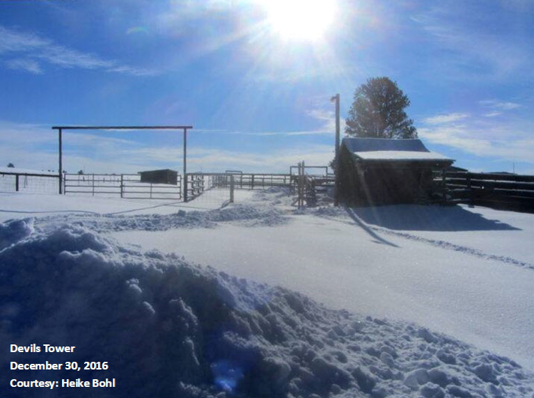
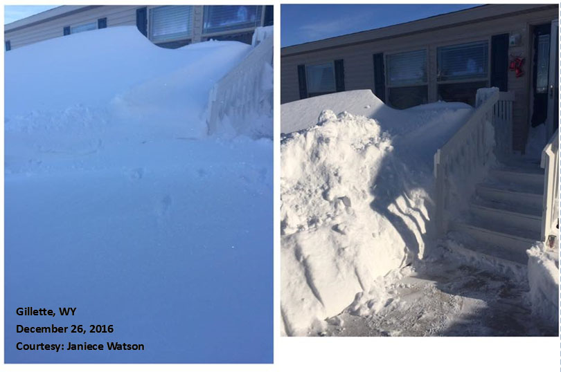
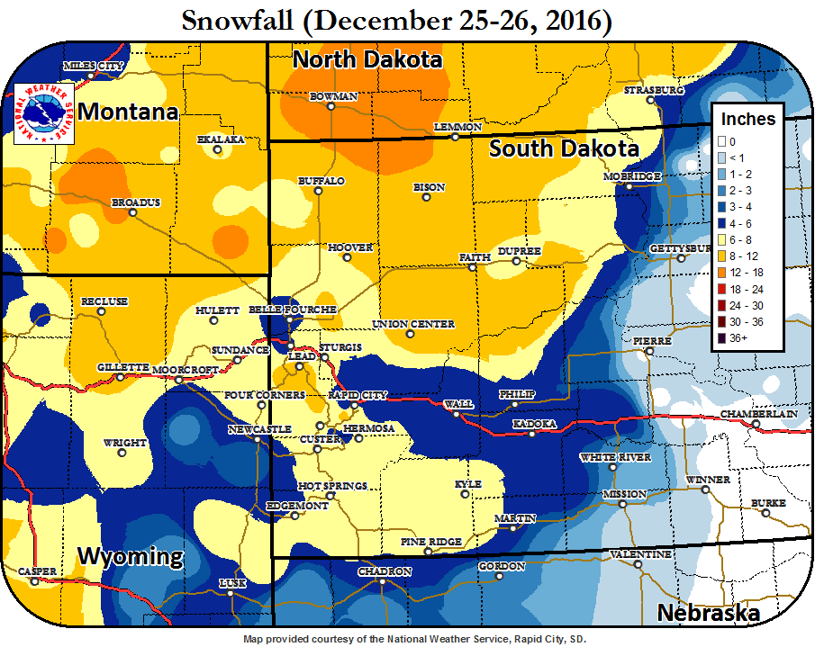
A strong low-pressure system brought heavy snow and very gusty winds to northeastern Wyoming and western South Dakota Christmas Day of 2016. Before the snow, some areas experienced freezing rain and sleet, creating a layer of icing. Generally, 4 to 12 inches of snow fell across the forecast area, with the highest amounts across northwestern SD, northeastern WY, and the Black Hills. Strong winds up to 72 mph created blowing snow, resulting in blizzard conditions across much of the area, even after the snow stopped falling. Many places had drifts several feet high.
 |
 |
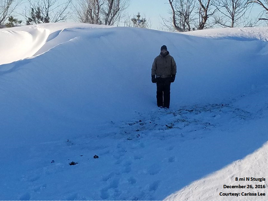 |
| Devils Tower | Gillette | 8 mi N Sturgis |
Snowfall Map
Storm Reports
THE STORM REPORTS LISTED BELOW ARE IN DESCENDING ORDER AND MAY NOT NECESSARILY
BE THE FINAL STORM REPORTS.


SNOW REPORTS LISTED BY AMOUNT

 INCHES  LOCATION                 ST  COUNTY           TIME
 ------  -----------------------  --  --------------   -------
 12.00   1 W GLAD VALLEY          SD  ZIEBACH          1200 PM
                 SOME DRIFTS 12-14 FEET HIGH
 11.00   LEMMON                   SD  PERKINS          0500 PM
 11.00   4 NNE ROCKERVILLE        SD  PENNINGTON       1212 PM
                 SNOW DRIFTS 6-12 INCHES HIGHER THAN SNOWFALL
                 AMOUNT.
 10.00   6 SSW LEAD               SD  LAWRENCE         0700 AM
  8.00   8 W OPAL                 SD  MEADE            1056 AM
  8.00   JOHNSON SIDING           SD  PENNINGTON       1006 AM
  8.00   DOWNTOWN HOT SPRINGS     SD  FALL RIVER       0907 AM
                 ESTIMATED 8 INCHES IN HOT SPRINGS MINNEKAHTA
                 VALLEY.
  8.00   OELRICHS                 SD  FALL RIVER       0902 AM
                 RAIN AT THE START OF IT THEN TURNING INTO
                 SNOW WITH THUNDERSNOW LATER IN THE MORNING.
  8.00   4 SE DOWNTOWN SPEARFISH  SD  LAWRENCE         0853 AM
                 ESTIMATED 8 INCHES NEAR MOUNTAIN SHADOWS
                 MOBILE HOME ESTATES IN SPEARFISH.
  8.00   SW HERMOSA               SD  CUSTER           0850 AM
                 7-8 INCHES OF SNOW SW OF HERMOSA. LIMITED
                 DRIFTING DUE TO INDIVIDUAL LIVING IN A
                 CANYON. NOT A LOT OF WIND WITH STORM.
  8.00   2 NNW SAINT ONGE         SD  LAWRENCE         0800 AM
                 DRIFTS UP TO 4-5 FEET DEEP.
  8.00   1 SSW DOWNTOWN HOT SPRI  SD  FALL RIVER       0700 AM
  7.50   5 E PORCUPINE            SD  OGLALA LAKOTA    0954 AM
                 ESTIMATED 7.5 INCHES OF NEW SNOW WITH DRIFTS
                 KNEE TO CHEST DEEP
  7.20   1 ESE PACTOLA RESERVOIR  SD  PENNINGTON       0846 AM
  6.80   5 SW DOWNTOWN RAPID CIT  SD  PENNINGTON       0700 AM
  6.00   2 N FOUR CORNERS         WY  WESTON           1002 AM
                 LIGHT SNOW STILL OCCURRING.
  6.00   DOWNTOWN CUSTER          SD  CUSTER           0930 AM
                 UP TO 24 INCHES DRIFTS
  6.00   SUNDANCE                 WY  CROOK            0908 AM
                 DRIFTS UP TO 2 FEET HIGH. HIGHEST WIND GUST
                 FOR STORM 42.5 MPH
  6.00   3 ENE KYLE               SD  OGLALA LAKOTA    0844 AM
  6.00   5 E PIEDMONT             SD  MEADE            0700 AM
  6.00   2 SSE DOWNTOWN RAPID CI  SD  PENNINGTON       0900 PM
  5.20   DOWNTOWN SPEARFISH       SD  LAWRENCE         0700 AM
  4.40   EDGEMONT                 SD  FALL RIVER       0845 AM


WIND GUST REPORTS LISTED BY SPEED (MPH)

 SPEED   LOCATION                 ST  COUNTY           TIME
 ------  -----------------------  --  --------------   -------
 72.00   3 E WICKSVILLE           SD  PENNINGTON       0510 PM
 67.00   1 NE WINNER              SD  TRIPP            0952 PM
 65.00   6 W PARMELEE             SD  TODD             0728 PM
 63.00   11 SW PARMELEE           SD  TODD             0710 PM
 63.00   6 WNW DOWNTOWN NEWCASTLE WY  WESTON           0215 PM
 61.00   1 N BUFFALO              SD  HARDING          1028 AM
 58.00   WEWELA                   SD  TRIPP            0750 PM
 58.00   4 SSE WITTEN             SD  TRIPP            0740 PM
 58.00   15 SSE MISSION           SD  TODD             0630 PM
 58.00   ELLSWORTH AFB            SD  MEADE            0417 PM
              VISIBILITY LESS THAN 1/4 MILE
 58.00   RAPID CITY AIRPORT       SD  PENNINGTON       0344 PM
              SUSTAINED WIND 44 MPH...VIS LESS THAN 1/4 MILE
 55.00   9 SW BATESLAND           SD  OGLALA LAKOTA    0610 PM
 |
Media use of NWS Web News Stories is encouraged! Please acknowledge the NWS as the source of any news information accessed from this site. |
|

