
Catastrophic Super Typhoon Bavi's eyewall has reached Rota and is expected to bring dangerous winds, heavy rainfall and storm surge to Guam, Rota, Tinian and Saipan. A Typhoon Warning remains in effect. Heavy to excessive rainfall will continue to bring a flooding threat from coastal Mid-Atlantic to southern New England through Monday. Read More >
Overview
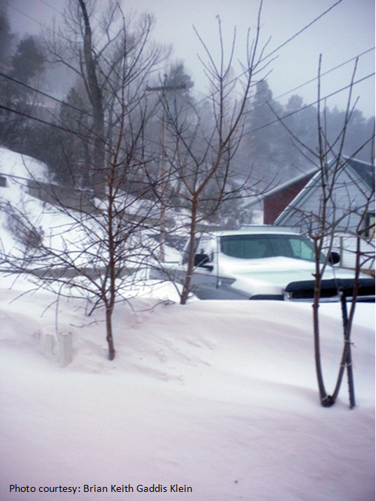
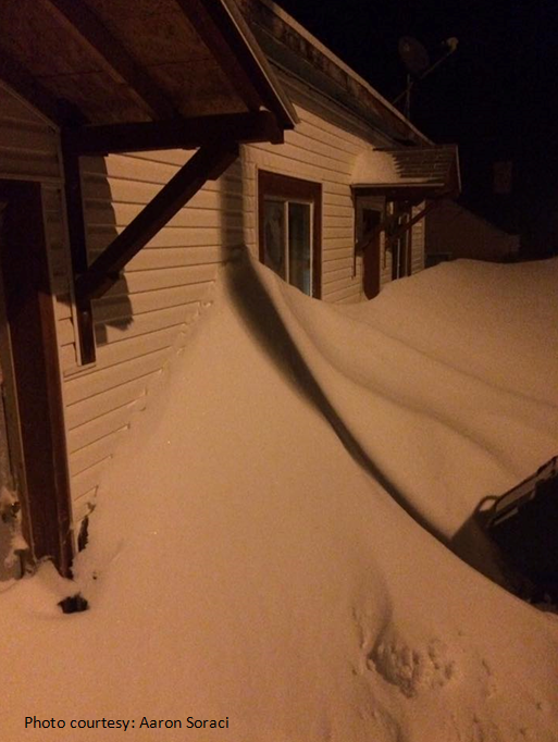
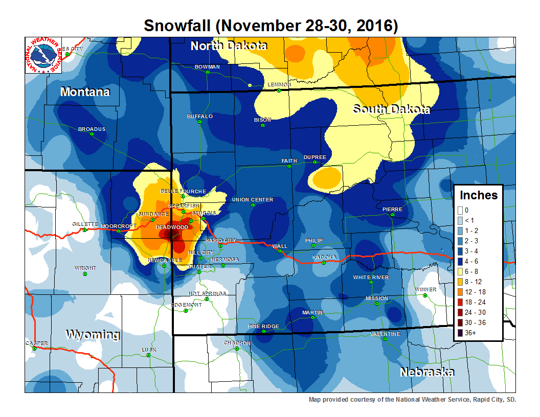
A strong low pressure system moved into the northern plains and stalled over the eastern Dakotas for a couple days, bringing a long duration of heavy snow and gusty winds to portions of northeastern WY and western SD. The heaviest snow fell over the upslope area of the northern Black Hills, where snowfall amounts of 2 to 3 feet were reported. Portions of northwestern and central SD received up to a foot of snow, while the downslope areas of southwestern SD and around the Rapid City area had little to no snow. Strong winds of at least 60 mph were reported on the plains just east of the Hills. On the afternoon the 30th snow and winds finally diminished across the area. The map below shows our snowfall reports. There are also a few pictures from the Lead area, along with a listing of some of the reports we received.
 |
 |
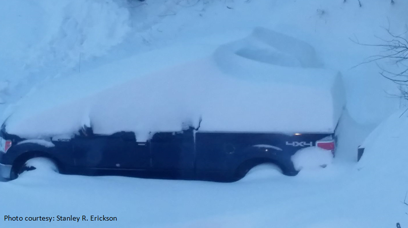 |
| Snow near Lead, SD | Snow near Lead, SD | Snow near Lead, SD |
Snow
Storm Reports
THE STORM REPORTS LISTED BELOW ARE IN DESCENDING ORDER AND MAY NOT NECESSARILY
BE THE FINAL STORM REPORTS.

SNOW REPORTS LISTED BY AMOUNT

 INCHES  LOCATION                 ST  COUNTY           TIME
 ------  -----------------------  --  --------------   -------
 36.00   11 SW CHEYENNE CROSSING  SD  LAWRENCE         0952 AM
 24.00   LEAD                     SD  LAWRENCE         0942 AM
                 AT LEAST 24 INCHES... MANY DEEPER DRIFTS
 14.00   LEAD                     SD  LAWRENCE         0700 AM
 14.00   1 NNE SUNDANCE           WY  CROOK            1159 PM
 10.00   FOUR CORNERS             WY  WESTON           1014 AM
  9.00   14 SSE DUPREE            SD  ZIEBACH          0800 AM
  6.00   1 NW PIEDMONT            SD  MEADE            0914 AM
  6.00   2 WSW SWETT              SD  BENNETT          0840 AM
  6.00   5 ESE ELM SPRINGS        SD  MEADE            0730 AM
  6.00   2 SSW NORRIS             SD  MELLETTE         0700 AM
  5.00   REVA                     SD  HARDING          0222 PM
  5.00   KEYHOLE RESERVOIR        WY  CROOK            0944 AM
                 SNOW DRIFTS UP TO 4 FT
  4.00   WALL                     SD  PENNINGTON       0803 AM
  4.00   3 ENE KYLE               SD  OGLALA LAKOTA    0700 AM
  3.00   2 E COTTONWOOD           SD  JACKSON          0700 AM
  3.00   PINE HAVEN               WY  CROOK            1005 AM
  3.00   2 E RALPH                SD  HARDING          0822 AM
  3.00   5 NNE BELLE FOURCHE RES  SD  BUTTE            0745 AM
  3.00   16 SE MISSION            SD  TODD             0700 AM
  3.00   9 WSW RED ELM            SD  ZIEBACH          0655 AM
  2.00   3 ESE PINE HAVEN         WY  CROOK            1000 AM
  2.00   1 ESE PACTOLA RESERVOIR  SD  PENNINGTON       0700 AM
  2.00   7 E LAKEVIEW             SD  TODD             0700 AM
  1.10   1 SW OGLALA              SD  OGLALA LAKOTA    0800 AM
  1.00   2 W OPAL                 SD  MEADE            0700 AM


WIND GUST REPORTS LISTED BY SPEED (MPH)

 SPEED   LOCATION                 ST  COUNTY           DATE/TIME
 -----   ------------------------ --  ---------------  -------------
 63.00   RAPID CITY AIRPORT       SD  PENNINGTON       11/29 1012 AM
 60.00   RAPID CITY AIRPORT       SD  PENNINGTON       11/29 0232 AM
 60.00   7 SW RAPID CITY AIRPORT  SD  PENNINGTON       11/29 0340 PM
 60.00   HERMOSA                  SD  PENNINGTON       11/29 0345 PM
 58.00   ELLSWORTH AFB            SD  MEADE            11/29 1213 PM
 |
Media use of NWS Web News Stories is encouraged! Please acknowledge the NWS as the source of any news information accessed from this site. |
|

